 Review by Duncan Hill Review by Duncan Hill
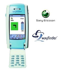
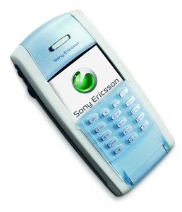
Wayfinder is a new product by Wayfinder. It's a GPS navigation system for Symbian based mobile phones, and Nokia have very recently started shipping Wayfinder and an Emtac GPS Receiver.
Wayfinder is an ideal solution for those who have the latest Symbian mobile phones, because it allows you to find a street, company, restaurant, in-fact any type of Point Of Interest (POI) quickly when you're in a foreign town. Wayfinder also allows you to save your destinations you enter, or use a call center to receive personal or automatic help.
The main features of Wayfinder are:-
- The map is always up-to-date.
- The solution gives access to personalised databases such as favourite destinations and points of interests.
- The solution also gives access to company information such as yellow pages and other types of points of interests.
- The solution provides the widest map coverage.
- You can enter the destination in many ways, both inside and outside the car and through a call-center.
- Traffic information is taken into consideration when routes are calculated (not available in the UK yet).
- The route is calculated and downloaded extremely fast compared to traditional systems.
- The solution is completely portable and versatile and can be used inside the vehicle as well as while walking or biking.
- The solution can easily be integrated with other existing business systems for professional users.
- The service is operator independent.
- The solution can use GSM, GPRS as well as future 3G networks.
- The product can easily be upgraded for additional functionality such as a drivers journal in the future.
- The solution has substantially lower cost of ownership than traditional navigation systems.
When you purchase Wayfinder, you receive 12 months of unlimited navigation in the country you have purchased it. You can purchase additional navigation direct on the Wayfinder navigation page.
All maps are stored on a central Wayfinder server on the internet which covers Western Europe and are updated several times a year with map corrections and Points Of Interest (POI).
Wayfinder connects to a Bluetooth enabled GPS Receiver via a Bluetooth connected Symbian mobile phone. The GPS Receiver that ships with Wayfinder is an Emtac BT GPS which we have reviewed previously at Pocket GPS World here. When you initiate Wayfinder, it will use a GPRS connection (or GSM if not available) and connect you to the Wayfinder internet server where you can then enter search and navigation requests. In a future release, you will be able to associate maps with traffic information for European countries that support TMC.
Re-Routing
If you are driving or walking and you go off your route, you will be asked to re-route by pressing a button to accept, or you can configure Wayfinder to automatically re-route you. When you are asked to re-route, you will be connected to the server again to download additional maps.
What is included ?
There are two packages available, the first comes without a GPS Receiver at 249 Euro's, and the second comes with a Wayfinder (re-badged Emtac) Bluetooth GPS Receiver at 499 Euro's. The second package comes with Bluetooth Receiver, Charger cable and 12 months Navigation Service.
Isn't GPRS expensive ?
Not really, Wayfinder suggest that an hours worth of driving should take around 5Kb of data download over GPRS, but it obviously does depend on the GPRS tariff and mobile operator you are with.
What happens after 12 months ?
As Wayfinder is a subscription service, your service will lapse after 12 months of use after activation. To continue the service, you will have to pay a further annual activation fee of 99 euro's for one region, or 149 euro's for unlimited navigation across Western Europe.
Which Version did we test ?
Even thought WayFinder has been available for the Nokia phones for some months now, the P800 version has just hit V1.1 (Pre Release), and this was the version we tested in this review. Hopefully a final release is imminent, current features list by version numbers whilst we were compiling this review were:-
 Version 1.11 Version 1.11
- Maps
- The maps are not downloaded to the phone until the Map View is selected. This means that if the map never is displayed, it is never downloaded!
- Small changes
- A lot of small improvements have been introduced in version 1.11, e.g.:
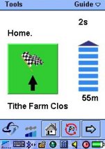
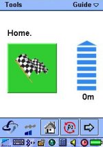
- Estimated time to goal is presented as hours and minutes.
- All strings are translated into Germany and Swedish (a few were unfortunately missing in 1.10).
- The search history is blank by default
- Search details are improved to increase readability
- The street name is only printed once for each search match
Version 1.10
- Maps
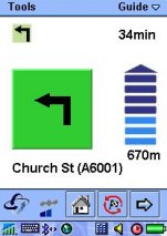
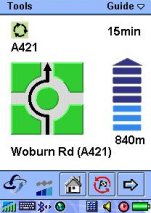
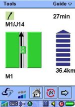
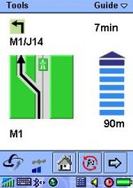
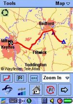
- Possible to navigate in the maps by zooming in/out and re-center the shown map. Short-cuts to show the entire route, the destination and the current position. The map on the Map View is increased so all available space is used. Top-left in the map is a small symbol with the next action to take, e.g. "Turn Left".
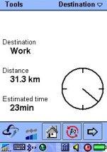
- Improved New destination
- The design of the New destination views is improved -- easier to understand and improved presentation of the information.
- Improved user interface
- Communication with the server is indicated by a rotating Wayfinder logo. The quality of the information from the GPS is indicated with an icon on the bottom toolbar, three bars is maximum quality and no bars indicate no information from the GPS. Text in many buttons in the application have been exchanged with symbols to increase the clearness. The size of a lot of the buttons has been increased as well.
 Version 1.09 Version 1.09
- English, German and Swedish versions
- Wayfinder for P800 is available in English, German and Swedish.
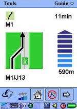
- Improved Guide-view
- Cleaned up the guide view. Increased the fonts and added information about estimated time to goal.
- Maps (still beta version)
- More stable functionality and a bit faster map display.
- Small errors removed
- A few small errors regarding negative coordinates and some problems when searching have been removed.
Version 1.08
- Maps (beta version)
- It is possible to show search matches and favorites in the map. During navigation the route will be shown together with the current position.
- Navigation between views
- It is possible to select the view to show by selecting in a drop-down box in the main menu. This is also used to show the name of the current view.
Version 1.07
- Settings option
- In the settings option, that is available under the Tools menu, the behavior of the application can be adjusted. This includes volume, back light, type vehicle (e.g. passenger car or pedestrian). It is also possible to request auto re-route when off-track.
- My Destinations
- Possible to add the current position to My Destinations and to edit all the information. The fields showing the details about the My Destinations are larger. The My Destinations are selectable by clicking on the jog-wheel on the phone.
- New Destination
- A spinning Wayfinder-logo indicates communication with the navigation server. The distance to the search matches is clearly shown.
- Guide view
- Small modifications to improve the readability, includes larger pictograms and removed headline.
- Map view
- Unfortunately this View is just a dummy view. The real map-functionality will be available in the middle of September (no matter what is said in the view).
A few points to bear in mind...
- Current UK version only support Km not miles, this will be added in future.
- If you are in an area with poor GPRS coverage routing is not possible, this could potentially cause problems.
- There will be a legal question relating to mobile phone usage after December this year in-car where usage of mobile phones are prohibited (most of this is down to picking the phone up and cradling it to your ear, but still using the phone in-car could look as though you are about to dial somebody)
- GPRS costs are very low, each route is downloaded at the start of a journey, further downloads are required for each reroute. Even then usage was acceptable.
- Upon registration you are issued with a User ID& password which gives access to a WEB based WayFinder Portal. This allows you to set preferences, create destinations & routes. Very useful as all planned routing can be managed using a standard PC. The destinations are then downloaded to the phone. Screenshot can be provided.
- Routing is similar to applications that use NavTech maps with the routes almost identical, there is no option to alter road speeds.
- Wayfinder is a very usable product, and considering it is using mobile phone technology I'm extremely impressed, it does what it say's well without all the fancy 3D views & POI
Summary
If you are in a foreign town on business, and need to know how to get to a specific location quickly, then Wayfinder is a very good service to use. However, it really can't replace a full navigation system due to the size of the screen and limited map detail. If you want a full-on navigation system, then our recommendation wouldn't be Wayfinder. However, if you are very rarely going to need routing in-car, and just want to know how to get to a location when you're lost and can't use a map, then Wayfinder is a very good backup service.
Purchase from

|


