Hi! We see you’re using an ad-blocker. We’re fine with that and won’t stop you visiting the site.
But as we’re losing ad-revenue from this then why not make a donation towards website running costs?. Or you could disable your ad-blocker for this site. We think you’ll find our adverts are not overbearing!
Joined: 11/07/2002 14:36:40 Posts: 23848 Location: Hampshire, UK
Posted: Sat Mar 15, 2008 4:56 pm Post subject: Satmap Walks
This is a new thread for walks in .map format for Satmap's Active 10 device. Using Satsync software available from Satmap's website (download here) you can easily export and import routes in .map format.
Initially users are requested to submit the files to me darrenATpocketgpsworld.com for inclusion in this thread which will be locked. We will gauge interest in this facility and if it proves popular we can look at better options for sharing the walks.
Please include a summary of the walk using the below walk as a guide, the .map file and if possible a screenshot of the route. I can always grab a screen-shot if you'd prefer so long as I have the .map file though.
Note
The .map files available here are a collection of waypoints only. They Do Not contain the map itself which you will need in order to take full advantage of the data. _________________ Darren Griffin
Last edited by Darren on Mon Apr 13, 2009 10:30 pm; edited 2 times in total
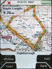
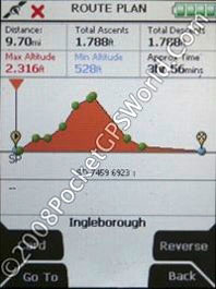
From the car park exit, turn right and cross the river Wenning via one of the bridges, continue to WP01 which is the true start. At first the walk uses part of a maintained pathway, access is granted via tickets (50p) from an automated machine in the farm yard. A gentle climb ensues to WP02 where you can visit Ingleborough cave or press on. The cave is well worth a visit if you have never tried it, allow an extra hour though in your planning for this. Heading to WP03 the steepness of the path increases considerably for a short ascent adjacent to Trow Gill.
On reaching WP03 use the stile to go over the dry stone wall and continue to WP04 Gapping Gill This is the largest underground chamber pot hole within the UK, whilst it is fenced off dont let kids or pets stray too close to this, tragedy has struck here before.
The path incline increases substantially on the way to the cairn at WP05, I generally shelter here for a quick snack and drink, there is a cairn at the summit but it gets too busy at times. From the cairn to WP06 is steep in places, other parts are flat but involve traversing a large boulder field, if its icy take extra care on this part. Once on the top its very flat, head for the summit at WP07. If the weather is good take in the spectacular views from the top, if, however you are in the cloud take care with next part of the walk. Aiming for WP08 you start with a very steep decent before the path flattens out to a gentle downward slope. Make sure you pick the path out before descending from the top, in bad weather this can be quite a challenge (I was glad of the 1:25K scale maps for this part). At WP08 there is a stile to cross the dry stone wall, take in the Ease Gill Force waterfall if you fancy a slight diversion off the route. A few more stiles while crossing grassy farm land and you will arrive at WP09 Slatenber Follow the road back to Clapham and the car park (This is the part of this walk I hate, 3 miles of undulating tarmac, it seems to take an age).
Joined: 11/07/2002 14:36:40 Posts: 23848 Location: Hampshire, UK
Posted: Tue Apr 22, 2008 9:33 am Post subject:
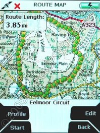
Eelmoor Circuit
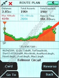
Distance: 3.8 miles
Time: 1 hr 30 minutes
A gentle 4 mile walk across an MoD Training Area and SSI. Expansive heath-land populated with deer and wild cattle. Since 1995, a group of bachelor stallions has also grazed Eelmoor Marsh.
From the car park the route follows the muddy track near to the entrance heading clockwise. To the left you will see Tweseldown Race Course and in the distance to the right is Farnborough Airfield. The frequently intersecting sandy tracks are occasionally used by the MoD for driver training but this expanse of heath and sand is otherwise untouched and a marvellous haven for birds and animals. Rare Dragonflies are frequently spotted in this area.
As you leave the boundary of the race course the heath ahead is good deer spotting territory, keep your eyes peeled for them crossing the tracks ahead. As you approach the tree line ahead the track bears right towards the airfield and then turns right again at the boundary near to the A323. The track gently rises and falls here as you follow the driving tracks with great views of the runway and approaches, a popular spot when the airshow is in progress!
Continuing on the route heads back into the wooded area and continued across the heath following a broad circuit around the extents of Eeelmoor. You can choose to lengthen the route or curtail it by dead heading back to the start following one of the many tracks and paths that criss cross the area. _________________ Darren Griffin
Last edited by Darren on Wed Apr 23, 2008 11:37 am; edited 1 time in total
Joined: 11/07/2002 14:36:40 Posts: 23848 Location: Hampshire, UK
Posted: Wed Apr 23, 2008 10:56 am Post subject:
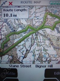
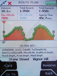
Stane Street Bignor Hill, West Sussex
Submitted by Frequent Flyer
Distance: 10 miles
Time: 4 Hours minimum
Note. This is a figure of eight walk, and the walk could be shortened accordingly.
Start Point. Eartham Wood Car Park OS SU 9384 1066
Stane Street Start* OS SU 9407 1060
*Driving into the car park (free of charges), Stane Street, starts at the far right hand side of the car park at the above grid reference, although it is very likely that you will be able to ask somebody if confused, as these woods are very popular with families, dog walkers and horse riders.
Recommended Map. OS Explorer 121
SatMap. South Downs/New Forest Premium or
West Sussex County Premium, both 1:25K.
Eartham Wood is situated off of the main A285, (Chichester A27 to Petworth road.)
Facilities. There are no facilities in either the car park or at the top of Bignor Hill. For those continuing the walk, both the villages of Bignor and Sutton have food, drink and toilets available, as well as Bignor Roman Villa museum.
Overview. This splendid walk starts by following the track of the original road completed by the Romans some 2000 years ago, linking Chichester, (Novomagus) with London, (Londinium.) Earthworks and drainage ditches can still be clearly seen. It is also part of the long distance Monarchs Way path, the route allegedly used by King Charles II in 1651, to escape the wrath of Oliver Cromwell !
Bignor Hill is on the top of the South Downs and the views have to be seen to be appreciated, the English Channel, Isle of Wight, both the South and North Downs. It also takes in a taster of the long distance path, the South Downs Way, which crosses at the top and is used for part of the walk. Whilst this walk will certainly stretch the legs it is a figure of eight deliberately, in order that those with children or the less able, can return the same way or via the returning loop having reached the top.
A word of advice. West Sussex is blessed with numerous, well signed footpaths/bridle paths and it is very easy to divert at many points on this walk should you wish but, do make sure you consult a map first. (While this is not the Lake District, there is much open space which can become confusing without a map.)
We start this walk on the long and steady climb up to Bignor, following in the footsteps of the Romans. The road was built using local flints, chalk and stones/pebbles, brought here by the Romans from local beaches around four miles away. Leaving the woods we are soon in National Trust land, passing Gumber Bothy Farm and Bothy (NT) on the right hand side. This is a useful stop for those on the South Downs Way or lightweight campers as an overnight stop, or picnic shelter if the weather is poor. Note the numerous Badger sets dug out of the flint and chalk downland. Bignor Hill car park is soon reached with its fantastic views. Note the four way footpath sign inscribed in Latin. Here, you need to decide whether to carry on or return by the return loop in which case bear West on the SDW and follow the route shown back down through the woods to the car park.
If you are very quiet and careful, you can easily see the wildlife, particularly the shy Deer and Skylarks which both breed and winter here. For those continuing, follow the SDW which you can see climbing away in front of you. Bignor Hill is actually the hill you pass by on your left. Pass the memorial to Tobys Stone, Here he lies where he wanted to be... a local Hounds Master. Continue to follow the route down to Bignor and, if time, visit the Bignor Roman Villa. A short, additional walk to Sutton, to The White Horse pub, (Tel 01798 869221) should be done, for a decent pint before the climb back up to Bignor. Back at the top, follow the path passing the pylons on your left, before shortly bearing left and making your way back down through the woods and back to your transport.
This is an easy 5.5 mile walk that is one of my all season favourites. I do
it with the dog but with a family, however you like to walk would seem to be fine. I believe it is also a cycle track but I have never seen a bike on
it. Normally quiet in the week you may meet a few people at the weekend.
A choice of parking places the main ones are either at SN 820271 (the one on the .map file) or SN 833286.
The walk runs through woods, open land where they have been felled, beside the reservoir and across the young river Usk. Views of both the Black Mountain and Pen-y-fan from one point. Also options to extend in various directions if you wish.
The .map file is pretty much as walked by myself in April 2008 but be warned my car was broken into in the quiet and otherwise deserted car park despite being in full view of the one road. I had foolishly left an old jacket on view. Make sure you leave nothing that may tempt anyone.
Have a great walk. _________________ Darren Griffin
Starts off from the village of Horton in Ribblesdale. Firstly there is a pay and display car park available, but this gets filled up very quickly at weekends. Fortunately a local farmer has opened a field for parking adjacent to the road bridge over the river, this is right on the edge of the village. £2 for the day and the car is pretty secure with other walkers constantly arriving/ departing.
Follow the river Ribble to WP03, do not cross under the railway line at this point, instead proceed to WP04 where you pass under the railway and cross the road to continue walking on grass rather than the narrow road surface.
Helwith Bridge Pub WP05 doesnt open until mid afternoon during the week, so if you fancy a pint try this walk in reverse. WP06 is a small distance away, cross the river by walking over the road bridge. Between WP06 and WP09 has recently been reclassified so dont be too surprised to see the odd four wheel drive vehicle or even motocross style bikes on this section.
WP08 is a quick route down should the weather be particularly poor, turning left at this point takes you straight back down to the village of Horton in Ribblesdale, should you need to.
Churn Milk Hole WP09, I always like to go and have a look at natural features that are named on a map, for no other reason than satisfying my inbuilt curiosity, this is yet another boring non descript hole in the ground, but knowing this I wont go to look at it a second time.
Fawcett Moor WP10, this again is a quick route down and the last one before heading for the summit, I usually pause around here for a bite to eat, as the next part is very steep indeed.
Pen-y-ghent summit WP11 on a clear day there are some fantastic views from the top which more than makes up for the hard effort getting up the accent, at times you need to use hands and feet while climbing the rock steps. This is not a walk I would take my children on, and when the conditions are wet the rocks can get slippery so take care.
Descending via WP12 and 13 the path is steep in places but not as bad as the accent, prior to WP14 is Hunt Pot, a slight detour off the footpath is required to see this natural feature. This one is a little more interesting that the previous, but again it is a hole in the ground.
From WP14 the path is more akin to a farm access track, made from hardcore and railway ballast it is not too kind on the feet, WP15 has you back in the village where you started out from, a short trip across the pedestrian only bridge will take you back to the alternate car park.
Posted: Today Post subject: Pocket GPS Advertising
We see you’re using an ad-blocker. We’re fine with that and won’t stop you visiting the site.
Have you considered making a donation towards website running costs?. Or you could disable your ad-blocker for this site. We think you’ll find our adverts are not overbearing!
You cannot post new topics in this forum You cannot reply to topics in this forum You cannot edit your posts in this forum You cannot delete your posts in this forum You cannot vote in polls in this forum
Or you could disable your ad-blocker for this site. We think you’ll find our adverts are not overbearing!
Hi! We see you’re using an ad-blocker. We’re fine with that and won’t stop you visiting the site.
But as we’re losing ad-revenue from this then why not make a donation towards website running costs?. Or you could disable your ad-blocker for this site. We think you’ll find our adverts are not overbearing!


 This is a new thread for walks in .map format for Satmap's Active 10 device. Using Satsync software available from Satmap's website (download