Hi! We see you’re using an ad-blocker. We’re fine with that and won’t stop you visiting the site.
But as we’re losing ad-revenue from this then why not make a donation towards website running costs?. Or you could disable your ad-blocker for this site. We think you’ll find our adverts are not overbearing!
And I wonder if this will be a Windows based application, thereby instantly knackering the product for those that don't use windows.
I thought there was a Microsoft connection with the Active 10, if so i wonder how Apple and Linux users will be handled.
Quote:
1) the joystick is sensitive, this seems to be calming down now, I don't know if I've gotten used to it or if it's getting used to me
The sensitivity needs to be adjustable as in a PC mouse, different people require different speeds.
Quote:
3) The options screen could be better laid out, and it should be easier to clear the 'snail-trail'.
I agree.
Quote:
4) Why does the device default to showing a specific location when a map card is inserted (North Britain defaults to Glasgow and apparently South Britain defaults to Leicester)?
And South East England points to Wimbledon in London. _________________ TomTom Go 60
Garmin Nüvi 660, Firmware v4.90
Drive-Smart GPS with Loader v1.4.16
HTC Advantage X7500 MS 6.1 Tchart Speed Sentry
Satmap Active 10, Software v1.16
Fuzion 32 HUD Bluetooth GPS receiver
well i have just been on the Satmap web site and there appears to have been some alterations. I now can't find any reference to 1:25 maps ;all
the 1:50 seem to have a coverage area shown (well i only sampled a couple).
I just wish the company would engage brain and get things sorted
The shop is closed, but the site speciifically refers to the 1:25 still.
http://www.satmap.com/about.php
Over 150 map titles will be available at launch, covering the whole of Great Britain at 1:25,000 and 1:50,000 scales. The country has been divided up into logical regions, so you no longer have to worry about what map number you live on: simply buy the map of your area.
* National Parks (1:25k AND 1:50k)
* National Trails (1:25k AND 1:50k)
* Regions (1:50k)
* Counties (1:25k or 1:50k)
Joined: 30/06/2003 08:05:15 Posts: 3 Location: United Kingdom
Posted: Mon Oct 29, 2007 5:16 pm Post subject:
robs1972 wrote:
I have been practicing by taking a screen cap of Memory Map and then in Paint Shop Pro using the cropping tool with a selector set at 320x240 and scrolling round the sreencap.....it appears to be fine for my intended use.
Interesting approach - I'll try it right now. But at what zoom level did you capture your MM image? Probably best way to specify that unambiguously is by the distance in km across screen.
Just found this thread, via uk.rec.walking, where I'd been getting helpful advice on upgrading my aging Garmin GPS 12. I was minutes away from ordering a Garmin 60CSX, probably with UK TOPO map. Plainly I now need to seriously consider the Active 10.
But it's also prompted me to think about yet another option. I have an (oldish) iPAQ 2210 Pocket PC, so I could get a much smaller GPS unit, i.e. a receiver only, such as Holux etc, with the latest sensitive circuitry, plus appropriate cable and case. My main motive for considering that approach is that I really baulk at paying so much over and over again for OS maps! Leaving aside all the paper maps I've bought, I now have a raft of digital OS 25k and 50k maps which I use with Memory-Map. I have not of course had any mapping on my venerable GPS 12. But with my PPC loaded with a map extracted from MM, showing my planned walk, supplemented by a paper map and possibly even an A4 colour print-out of my planned walk in a waterproof map-holder, I've usually been happy enough. And of course my PPC also has 2GB of music, all my contacts, task list, frequently-used text files, calendar, etc.
BTW, cost of Active 10 'South East' map 50k set covering Hampshire, Sussex, Kent, etc, would be £50. Individual 25k for say Surrey would be £80. (source: Richard at SatMap, an hour ago.)
Yet another factor occurs to me. My car still has no sat-nav. Maybe I should include that in the equation in pursuit of an integrated solution? Decisions, decisions...
Joined: Mar 19, 2007 Posts: 310 Location: Plymouth
Posted: Mon Oct 29, 2007 7:08 pm Post subject:
terrypin wrote:
robs1972 wrote:
I have been practicing by taking a screen cap of Memory Map and then in Paint Shop Pro using the cropping tool with a selector set at 320x240 and scrolling round the sreencap.....it appears to be fine for my intended use.
Interesting approach - I'll try it right now. But at what zoom level did you capture your MM image? Probably best way to specify that unambiguously is by the distance in km across screen.
This is the kind of zoom level I had....it was just a way of seeing what looking at a map through a very small screen was going to feel like. Opacity of the border of the crop tool was 100
_________________ I like mapping, I like mapping, I like mapping and I like to map!
The thing is I am able to zoom in quite a considerable distance on a 1:50000 scale map. The writing on the map becomes a little diffuse as the software smoothing kicks in but it all quite readable. It really isn't an issue.
The map goes down to ~1:7000 which means that the screen displays about 750 feet across and ~1600 feet up and down... all quite clearly.
A handy feature I used today was walking a hill walk I've taken a few times and then converting the snail trail into a route. I got profile infomation for it including height gain, loss, avg speed, etc all without additional software... ace. I imagine editing it by hand on the unit will be a pig..but thats what the online tool will be for.
Talking of which, I still hope really hope it won't be windows only. The unit is WindowsCE based, but it may as well run by magic. There's no splash screen or markings advertising the fact... which is a good thing.
Joined: Mar 19, 2007 Posts: 310 Location: Plymouth
Posted: Mon Oct 29, 2007 9:50 pm Post subject:
I should point out that exercise was before I bought the unit and was inspired by a comment on the walking forum mentioned earlier that said it would be crap or annoying trying to navigate by such a small sample of map at any one time....and in a way it is slightly if you are using it to plan a route in an area you don't know but when following a route you have created elsewhere it appears to be fine for my needs.
I don't think I was ever worried about zooming in enough, someone on the walking forum scoffed at the 1:7000 or whatever that was claimed it could zoom in to as just a marketing gimmick....probably said by the kind of person that uses a map magnifier but can't make the link between the two things...magnifiers can't add detail either!! _________________ I like mapping, I like mapping, I like mapping and I like to map!
Joined: Jan 14, 2005 Posts: 19638 Location: Blackpool , Lancs
Posted: Mon Oct 29, 2007 10:36 pm Post subject:
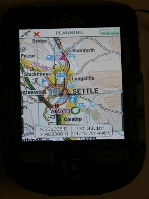
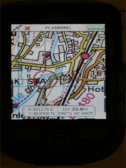
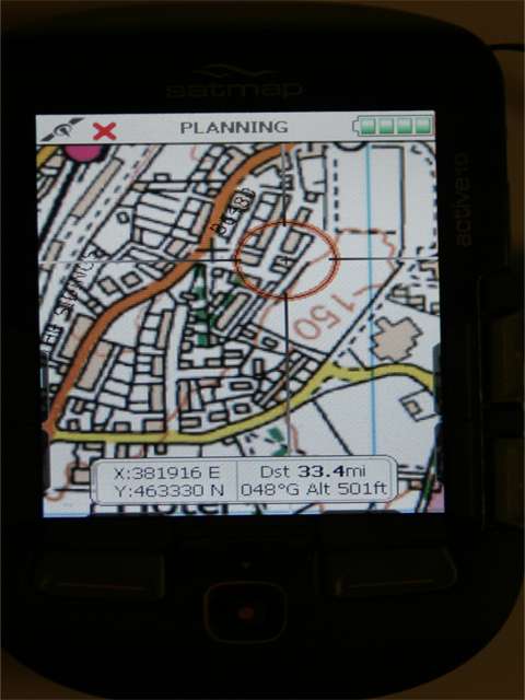
I am not going to post up many pictures of the unit for a while, but in answer to the screen and mapping res I have just taken these pictures of my unit, they are not good pictures as its dark in the PC room, but rather than mess around with windows on existing maps these are from the device:
The map information screen:
The as supplied "Road Map":
Zoomed in to display the 50K scale coverage
When you zoom in to close detail the unit switches to 25K scale:
Oh and the reason the images look slightly out of ratio is due to me hand holding the camera, must get the tripod out for this sort of work in future! - Mike
true... but maps don't show your current location. At this magnification, if you choose to show road names, they will be shown too. Not all roads are named, and obviously if you're in the middle of a bog on the north yorkshire moors it's of very little help, but its there if you need it.
I've only used this unit in anger once and it was still all new to me. I think I'm going to enjoy using this device a lot. It all depends on the software yet to be released and the web site being fully released (including on-line planning tool). That would make this a truely great product.
Joined: 30/06/2003 08:05:15 Posts: 3 Location: United Kingdom
Posted: Tue Oct 30, 2007 12:40 pm Post subject:
finkployd wrote:
[snip]
I got profile infomation for it including height gain, loss, avg speed, etc all without additional software... ace. I imagine editing it by hand on the unit will be a pig..but thats what the online tool will be for.
Is 'height gain' what I call cumulative ascent? On a walk I would want to know that, and the cumulative descent (identical for a circular walk of course).
Yes... I don't know the exact wording the thing uses, but thats what I thought it to be.
Some way of saving this infomation on a trip by trip basis would be useful too.
The manual is not the most detailed document I've ever seen, but it gets you started.
Oh.. and I've lost my first gromet cover thing that covers the USB port. Why couldn't they mould it into the unit like thay have the SD cover?
Oh.. and I've lost my first gromet cover thing that covers the USB port. Why couldn't they mould it into the unit like thay have the SD cover?
The quality of the unit is great until they got to this gromit cap, then it looks as if they run out of ideas or time.
When the unit gets dropped, this end will hit the ground first due to the batteries position, how will we get the mud out of the USB port? _________________ TomTom Go 60
Garmin Nüvi 660, Firmware v4.90
Drive-Smart GPS with Loader v1.4.16
HTC Advantage X7500 MS 6.1 Tchart Speed Sentry
Satmap Active 10, Software v1.16
Fuzion 32 HUD Bluetooth GPS receiver
Joined: Mar 19, 2007 Posts: 310 Location: Plymouth
Posted: Tue Oct 30, 2007 6:47 pm Post subject:
GJF wrote:
finkployd wrote:
Oh.. and I've lost my first gromet cover thing that covers the USB port. Why couldn't they mould it into the unit like thay have the SD cover?
When the unit gets dropped, this end will hit the ground first due to the batteries position, how will we get the mud out of the USB port?
Well currently the USB port serves no purpose whatsoever....it might as well store soil samples!! _________________ I like mapping, I like mapping, I like mapping and I like to map!
Joined: Mar 19, 2007 Posts: 310 Location: Plymouth
Posted: Wed Oct 31, 2007 7:01 pm Post subject:
Baptised it today with an 80 miles ride and the review will follow soon. There were a couple of issues but nothing to stop me being very pleased with it. _________________ I like mapping, I like mapping, I like mapping and I like to map!
Posted: Today Post subject: Pocket GPS Advertising
We see you’re using an ad-blocker. We’re fine with that and won’t stop you visiting the site.
Have you considered making a donation towards website running costs?. Or you could disable your ad-blocker for this site. We think you’ll find our adverts are not overbearing!
You cannot post new topics in this forum You cannot reply to topics in this forum You cannot edit your posts in this forum You cannot delete your posts in this forum You cannot vote in polls in this forum
Or you could disable your ad-blocker for this site. We think you’ll find our adverts are not overbearing!
Hi! We see you’re using an ad-blocker. We’re fine with that and won’t stop you visiting the site.
But as we’re losing ad-revenue from this then why not make a donation towards website running costs?. Or you could disable your ad-blocker for this site. We think you’ll find our adverts are not overbearing!