 Review by Dave Burrows Review by Dave Burrows
Over a year ago Mike reviewed the Garmin GPSMap76. A little after which I purchased a GPSMap76S, but as with all things when you have a receiver for a long time at your beck and call, a review seems to just not appear and we have been extremely busy with some of the newer GPS products hitting the market, but I have finally found the time to write a GPSMap76S Review.
I would like to say that there are only a few differences between the GPSMap76 and GPSMap76S, but we will go back over the main features of the Garmin GPSMap76S.
For anyone that hasn't seen one and would like to read a full review, and we will also highlight the main differences between the two products.
If you would like to just see the main differences, please jump down to the Differences section of this review.
In The Box
The Garmin GPSMap76S receiver is priced at around £305 including VAT at the time of writing this review compared with the Garmin GPSMap76 at £245 including VAT.
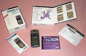 The GPSMap76S comes complete with a quick reference guide, a full manual, and an interface cable to a PC. The GPSMap76S comes complete with a quick reference guide, a full manual, and an interface cable to a PC.
The Garmin comes with a base map but has been designed to work with a number of additional downloadable maps. The one we reviewed was the MetroGuide Europe CD which on a double CD provides management software and map data for the Garmin courtesy of NAVTEQ Maps.
The cable set we used was provided by PC-Mobile is a number of modular pluggable cables which can be set into a number of configurations or you can by a new adapter for another Pocket PC without having to by a complete lead set.
Garmin GPSMAP 76S Specification
The manufacturer's specification are quoted here.
Navigation Features
Waypoints/icons: 500 with name and graphic symbol, 10 nearest (automatic), 10 proximity
Routes: 50 reversible routes with up to 125 points each, plus MOB and TracBack® modes
Tracks: Automatic track log; 10 saved tracks let you retrace your path in both directions
Trip computer: Current speed, average speed, resettable max. speed, trip timer and trip distance
Alarms: Anchor drag, approach and arrival, off-course, proximity waypoint, shallow water and deep water
Tables: Built-in celestial tables for best times to fish and hunt, sun and moon rise, set and location
Map datums: More than 100 plus user datum
Position format: Lat/Lon, UTM/UPS, Maidenhead, MGRS, Loran TDs and other grids, including user grid
|
GPS Performance
Receiver: WAAS-enabled, 12 parallel channel GPS receiver continuously tracks and uses up to 12 satellites to compute and update your position
Acquisition times:
Warm: Approximately 15 seconds
Cold: Approximately 45 seconds
AutoLocate™ Approximately 2 minutes
Update rate: 1/second, continuous
Antenna:
Built-in quadrifilar, with external antenna connection (MCX)
|
GPS accuracy:
Position: < 15 meters, 95% typical*
Velocity: 0.05 meter/sec steady state
DGPS (USCG) accuracy:
Position: 3-5 meters, 95% typical*
Velocity: 0.05 meter/sec steady state
DGPS (WAAS) accuracy:
Position: < 3 meters, 95% typical*
Velocity: 0.05 meter/sec steady state
Dynamics: 6 g's
Interfaces:
RS232 with NMEA 0183, RTCM 104 DGPS data format and proprietary GARMIN
Differential:
DGPS (USCG and WAAS capable) |
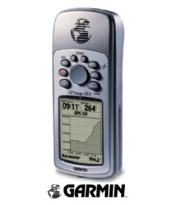
The Garmin GPSMap76S Receiver
The Garmin GPSMAP76S receiver fits quite nicely into the palm of your hand. It is controlled by a small 4 way rocker pad surrounded by eight function buttons.
The unit is reportedly completely waterproof and will even float if dropped overboard from a boat. Needless to say as this was a loan unit we did not verify that. One nice feature is that the base of the receiver is rubberised so will stay pretty much where you place it and will not slip out of your hand easily.
The display is a four shade FSTN screen with backlight. It has a high resolution screen of 180 by 240 pixels.
On the back of the receiver there is the quarter turn battery locking mechanism hiding the two AA sized batteries. It is possible to use rechargeable cells, but you must bear in mind that they supply 2.4 volts as opposed to 3 volts.
The operational life of a pair of AA batteries is such that it does not break the bank using non-rechargeable alkaline batteries.
Also on the back located behind a rubber gasket is the Garmin proprietary interface connector. It is this connector that allows the Garmin to be interfaced to either a PC or more importantly your PDA.
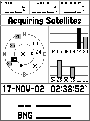
GPS Satellite Fixing
 Well the first thing to do was get a satellite fix. Having been used to other units I put some fresh batteries in the receiver placed it on the windowsill and went to make a cup of coffee. Imagine my surprise to return after a minute to find that the receiver had managed to perform a factory fix in that time. Partly due to the superb Quad Helix antenna that the GPSMap76S has. Well the first thing to do was get a satellite fix. Having been used to other units I put some fresh batteries in the receiver placed it on the windowsill and went to make a cup of coffee. Imagine my surprise to return after a minute to find that the receiver had managed to perform a factory fix in that time. Partly due to the superb Quad Helix antenna that the GPSMap76S has.
This became a common theme throughout my experience with the Garmin. Holding a fix is just as important as getting the first fix, and here the Garmin excelled.
During my testing in the car the Garmin managed to lock onto at least 2 and sometimes more than my other GPS Receivers.
Even with the receiver deep in the car between the seats it still managed to hold onto as many satellites as my other unit in prime position on the windscreen. Amazingly the GPS receiver even managed to hold a lock when in my pocket whilst walking in the woods. It did occasionally loose a fix in these conditions but almost as soon as I pulled it out of my pocket it re-acquired the lock.
WAAS
 WAAS what is it? WAAS stands for Wide Area Augmentation System. It's a system of satellites and ground stations that provide GPS signal corrections, giving you even better position accuracy. How much better? Try an average of up to five times better. A WAAS-capable receiver can give you a position accuracy of better than three meters, 95 percent of the time, and you don't have to purchase additional receiving equipment or pay service fees to utilize WAAS. You can find out more about WAAS at http://www.garmin.com/aboutGPS/waas.html WAAS what is it? WAAS stands for Wide Area Augmentation System. It's a system of satellites and ground stations that provide GPS signal corrections, giving you even better position accuracy. How much better? Try an average of up to five times better. A WAAS-capable receiver can give you a position accuracy of better than three meters, 95 percent of the time, and you don't have to purchase additional receiving equipment or pay service fees to utilize WAAS. You can find out more about WAAS at http://www.garmin.com/aboutGPS/waas.html
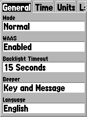
OK so WAAS is good, but it does not come configured as standard. You need to go into the Setup Menu and enable WAAS as shown on the left. Once enabled you need to initialise the receiver with a good view of the sky and you should see your GPS fixes change into Differential fixes.
How can you tell if you are getting WAAS fixes? First of all on the sky page you will see differential fix messages and in the satellite strength bars a 'D' will appear indicating that the satellite is being used in the WAAS fix. The image below shows a 3D Differential fix which was obtained on my office windowsill.
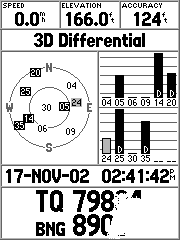
The sequence and messages displayed are as follows:
- Acquiring Satellites is displayed when the receiver is first switched on, or if you have lost your fix for some reason. This means that the unit is attempting to get a fix.
- 2D GPS Location is shown when the GPS receiver has a fix on 3 satellites. When you get a 2D fix the receiver can display your position but not your altitude.
- 3D GPS Location is displayed when there is a fix on 4 or more satellites. In this mode the GPS unit can display both position and altitude.
- 2D Differential Location indicates that the receiver is using either DGPS or WAAS differential data on 3 satellites
- 3D Differential Location shows that the GPS unit is receiving differential data on 4 or more satellites. This is the most accurate fix you get with this receiver.
In Use
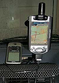
The first time I used this at home was connected to my iPAQ 3870.
Configuring the GPSMap76S to use the interface as NMEA will allow you to output the data to a Pocket PC, or PC and use any NMEA compliant GPS application on these devices to use the GPS data feed from the Garmin handheld. 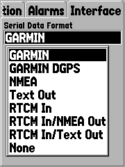
The baud rate is automatically set to 4800 and cannot be changed but this really isn't a limitation as most GPS Receivers that work in NMEA mode default to 4800 or prefer to work at 4800 baud.
I also used the unit with just the base map installed around my local area. This was somewhat disappointing as the roads did not line up with with the GPS location very well, being over 1/2 a mile out in some cases. This I knew was the base map at fault and not the receiver as it provided accurate positioning when connected to my PC software. The base map contained only the major roads in my area, suitable for locating your position, subject to the noted error above.
I loaded the Map Source MetroGuide Europe software, downloaded the maps to the GPSMap76S and went out again. This time the maps were spot on. They located me exactly where I was. The roads are sources from the NAVTEQ database.
The maps were also useful when out walking, though not showing footpaths, you could see when you were near roads. Setting waypoints and routes was reasonably easy and you can use PC based applications like OziExplorer and Fugawi to transfer the data to the Garmin.
The Garmin has sets of displays named pages. These are the Satellite Page, the Map Page, the Compass page, the Highway page, the Route page.
 The satellite page has been discussed above and provides basic information about the satellite positions and strengths. It also shows details such as your position in selected co-ordinates, speed, height and accuracy. The satellite page has been discussed above and provides basic information about the satellite positions and strengths. It also shows details such as your position in selected co-ordinates, speed, height and accuracy.
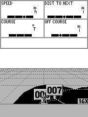
The map page shows the available map data, superimposed with you route, waypoints, tracks etc.
You can either have a full screen map or you can show some information at the top of the screen. By default the fields are your speed, and the distance to the next waypoint on your route.
By pressing the menu button you can set up the fields displayed on the screen, and other options for the map display.
In general this applies to all pages. Pressing the menu button displays context sensitive options for the page as shown on the right. Pressing the menu button again will display the main setup menu.
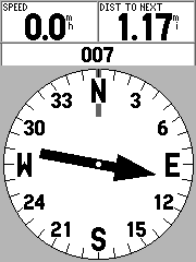
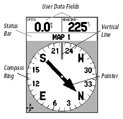
The other pages are displayed here. To the left is the highway page whilst to the right is the compass page.
The highway page shows a 3D representation of the current map. Placed on the display are the waypoint labels and also the track where visible. The large black line shows the path to the next waypoint on the route.
 Connecting it up Connecting it up
One of the beauties of this system is the ability of the Garmin to connect to just about anything with a serial port. This means that you can connect to your PDA, laptop, or even PC.
Why I hear you ask, would you want to connect it to a PC ? The answer is simple, you can upload the Map Source maps, routes, and waypoints from the computer to the Garmin. You can also download your routes, tracks, and waypoints from the receiver to the computer.
Of course if you have a laptop computer you can actually connect the Garmin to it and use GPS aware applications, like Autoroute, Fugawi, or OziExplorer, and plot your position.
 When conneceting the cables from PC-Mobile I found the cables all fitted perfectly. When conneceting the cables from PC-Mobile I found the cables all fitted perfectly.
When in use the Garmin had a fix even before I had connected the system up let alone started the car. Having got a fix it was able to retain the fix better than the other iPAQ GPS hardware systems I used. The downside was that there are more cables to try and tidy away from view and the Garmin was running on battery power though it did last over 16 hours on one set of batteries.
Strengths and Weaknesses
The unit tested is one of the top of the range of handheld GPS systems available. For my purposes it had too many features on it as I really only wanted a GPS receiver with a serial link to the iPAQ, so this was a very expensive solution. Garmin and others do produce cheaper units for just over £100 which compare favourably in price to sleeve and Compact Flash GPS devices.
The flexibility of the system is good, this is the first GPS receiver that I had which could be used on it's own, with a Laptop, or with a PDA. This allowed me to do just about anything I wanted to with GPS applications. The only drawback in this configuration was the cable link between the GPSMAP 76 and the PDA. This was more of a problem when cycling as I needed to mount both devices. In the end I just used the Garmin and connected it to the iPAQ when I wanted to check the map on Fugawi or OziExplorerCE.
The biggest plus has to be the TTFF and the units ability to retain the fix even in adverse and unsuitable conditions. Fixing took slightly longer when travelling but on the occasions that I tried it whilst moving between 40 and 50MPH the system fixed in under 40 seconds.
 Electronic Compass Electronic Compass
The GPSMap76S comes built-in with an Electronic Compass. This was one of the main features that I was looking for when I purchased the Garmin GPSMap76S as I wanted a built-in Electronic Compass, and the GPSMap76S was one of few GPS Receivers that offered a true electronic compass.
The compass is best used for navigation when a straight line course cannot be followed. The compass page has several user selectable fields. There are two options on the GPSMap76S that the compass page can use. Firstly it can navigate using the electronic compass, or it can navigate using the GPS Receiver. When travelling at 10mph or less for more than 90 seconds, the GPSMap76S is programmed out of the factory to use the Electronic Compass. When travelling over 10mph the GPSMap76S will switch back to using the GPS Receiver for navigation. These settings can be changed if you want.
When you are travelling directly toward the waypoint, the pointer will line up with the vertical line in the compass ring.
Electronic Barometer 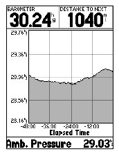 The GPSMap76S has a built-in Electronic Barometer. A barometer isn't a first on a Garmin product, the Garmin eTrex Vista has a barometer, but the barometer on the Vista will show you a change in pressure when you travel up and down. The GPSMap76S has a built-in Electronic Barometer. A barometer isn't a first on a Garmin product, the Garmin eTrex Vista has a barometer, but the barometer on the Vista will show you a change in pressure when you travel up and down.
With a proper barometer you should not see this increase or decrease when moving up or down except for when the atmospheric pressure changes. This is where the Garmin GPSMap76S's Electronic Barometer comes in handy as it operates as you would expect an Electronic Barometer would operate. You will have to calibrate the GPS Receiver which can take up to an hour for the calibration of the barometer.
The Barometric altitude is displayed on all the screens except for the satellite page where only the altitude appears.
The ambient pressure is what you would read from say a mercury barometer. As you increase altitude the ambient pressure goes down and likewise, if you decrease in altitude, the ambient pressure goes up, so if you are plotting the change in ambient pressure and altitude, you will see that these closely conform to each other, but are the inverse of each other.
 Differences Differences
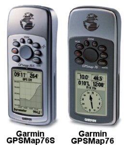
There are a few noticeable differences between the GPSMap76S and the GPSMap76, apart from the price which is one, check out the following feature differences.
- The first major difference between the GPSMap76 and GPSMap76S is the amount of memory available for loading MapSource maps into. The GPSMap76 currently only has 8mb RAM where the GPSMap76S has 24mb which allows for loading of larger map segments.
- The second major difference is that the GPSMap76S has a built-in Electronic compass which allows you to hold the GPS at any angle and still get a proper reading from it.
- The third major difference is that the GPSMap has a built-in barometric altimeter.
- The case colour on the GPSMap76S is a lot nicer in a more metallic look
- One of the downsides to the GPSMap76S is it only has around 10 hours battery runtime compared with the GPSMap76 which has a runtime of around 16 hours.
Garmin Maps / Cartography
If you are looking to load maps onto the Garmin GPSMap76S, then you do need to use Garmin Maps, but check out our other article on what sort of maps are available.
Click above to visit the Garmin Maps Article
Conclusion
The GPSMap76S is a great handheld, it's waterproof has an electronic compass and barometer, and is probably one of the better Garmin handheld's for hiking, mountaineering and fell walking.
|


