|
|
 |
 |
 |
 |
Uber Using 3D Modelling to Improve Urban GPS Accuracy
Article by: Darren Griffin
Date: 20 Apr 2018
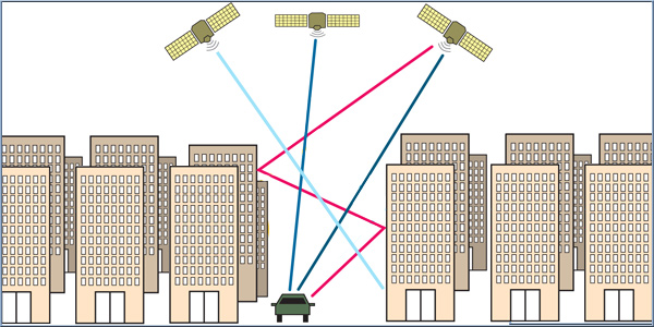
An interesting article comes courtesy of The Verge. Whilst GPS location accuracy has improved in leaps and bounds one problem still remains, the so-called urban canyon where GPS signals are often blocked by high-rise buildings and there are not enough available satellite signals to provide an accurate location due to the signal 'shadows' these buildings create.
For most of us this won't cause a huge issue, if our satnav can get us to the right street then we're happy, but for Uber this inaccuracy can be a big issue, they need both their drivers and their customers to receive accurate location information. If an Uber is parked waiting on one corner but the Uber app shows him on another then there is a risk that a ride might be cancelled if the customers struggles to locate their driver using the Uber app.
Two Uber engineers, Andrew Irish and Danny Iland, both former PhD students at UC Santa Barbara, came up with a solution for this issue and their startup business, Shadow Maps was acquired by Uber in 2016.
In essence they use 3D models of a city combined with the limited satellite signal to calculate the true position of a vehicle and then adjust the location in the app in real-time.
Source: theverge.com
|
|
 |
 |
 |
 |
|
|


