|
|
 |
 |
 |
 |
Residents on LAs steepest street call for satnav to avoid it
Article by: Darren Griffin
Date: 6 Apr 2018
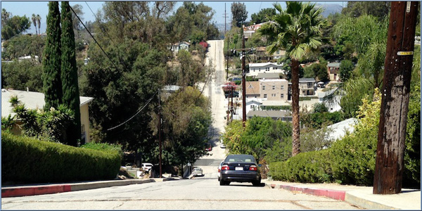
Whilst most of us think the plethora of traffic-aware GPS apps make our lives easier, the residents of Baxter Street in Los Angeles are not so joyous.
Located in a previously quiet neighbourhood, Baxter Street, famous for being one of the steepest streets in the US with a 32% grade and built long before cars were omnipresent, has become a busy rat run as drivers, following navigation apps, are directed along it to bypass congestion on the nearby Glendale Boulevard.
And this increase in traffic is causing problems. Drivers, unfamiliar with the Himalayan incline (so steep that drivers see only sky ahead of them as they climb) get stuck or their vehicles lose grip in wet or cold weather and slide backwards. Residents have had gardens demolished, walls and fences smashed, trucks and buses get grounded on the crest and now they've had enough.
Residents have asked their local Transportation Department for assistance in getting the street flagged on satnav as unsuitable or dangerous.
Source: LA Times.com
| Comments
|
 Posted by ds47uk on Fri Apr 06, 2018 7:42 am Posted by ds47uk on Fri Apr 06, 2018 7:42 am |
 |
So now everyone in LA who wasn't aware of this will think "Oh! I must have a go on that street! Sounds fun"
|
|
|
|
 |
|
|
 |
 |
 |
 |
|
|


