|
|
 |
 |
 |
 |
Mystery island on Google Maps isnt actually real
Article by: Darren Griffin
Date: 22 Nov 2012
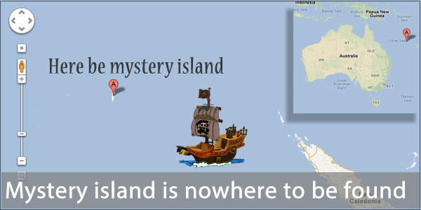
Here's an interesting story. Researchers spotted an oddity on Google Maps. An island was shown in the middle of the Coral See off the Eastern coast of Australia.
But what most attracted interest was that the marine charts for that area showed depths in excess of 1,400 metres, which would be highly unusual so close to a land mass. So they set sail for the island to investigate. And what they found, or more accurately what they didn't find, was any island whatsoever.
Despite being shown on maps from Google (look at -19.225583, 159.938759), Yahoo and Bing, there is no island at those coordinates. How it came to appear in these maps is a mystery, perhaps it was inserted by a map maker and used as a watermark to identify the originator?
Source:
| | |  |
| Comments
|
 Posted by M8TJT on Thu Nov 22, 2012 2:00 pm Posted by M8TJT on Thu Nov 22, 2012 2:00 pm |
 |
| News Team Wrote: | | <perhaps it was inserted by a map maker and used as a watermark to identify the originator? |
And his name was Sandy  It's fresh out of roads and speed cams though. It's fresh out of roads and speed cams though.
|
|
| Posted by GerryC on Thu Nov 22, 2012 2:31 pm |
|
Looking at both satellite view and Earth it does appear to be on top of a large peak. Maybe it seemed to rise above sea level or the top has eroded away.
In any case, it appears someone has taken a black marker pen to both current and historic images (was it like this before the news broke.  ). ).
According to the BBC, copyright traps are not made on this type of map.
Gerry
Gerry
TomTom730T
Cameralert for Android
Brodit ProClip mount |
|
| Posted by Darren on Thu Nov 22, 2012 4:44 pm |
|
| GerryC Wrote: | | According to the BBC, copyright traps are not made on this type of map |
That comment relates to nautical maps though. No-one has said it appears on nautical charts.
Darren Griffin |
|
| Posted by M8TJT on Sun Dec 02, 2012 9:40 am |
|
The island seems to have been covered by sea on the map now. It is visible for a fraction of a second before it now becomes sea. The black blob on the sat view is still there though.
|
|
| Posted by Andy_P on Sun Dec 02, 2012 5:43 pm |
|
I hadn't twigged the bit about the satellite images...
I was assuming the news was that a non-existent island had been added to the maps due to an error or mischief
But if the island (or something else?) WAS on a photograph, that's a much bigger mystery isn't it?
"Settling in nicely" ;-) |
|
| Posted by M8TJT on Sun Dec 02, 2012 10:49 pm |
|
No, it's not actually shown as an island on sat view, just looks like someone has been let loose with a black marker pen.
|
|
| Posted by Andy_P on Sun Dec 02, 2012 11:33 pm |
|
I know it looks like that now, but there's definitely something under the black blob.
The coastline looks similar in colour and texture to the other nearby islands.
And SOMEONE gave it a name too.
"Settling in nicely" ;-) |
|
|
|
 |
|
|
 |
 |
 |
 |
|
|


