|
|
 |
 |
 |
 |
Marvel at this preGPS 1980s navigation protoype
Article by: Darren Griffin
Date: 7 Apr 2016
Many of us have grown up with GPS, some of us were early adopters and survived the early versions which had laughable requirements such as having to plan a long distance journey in segments with each county being a separate map that you loaded and a journey from Hampshire to Cornwall treated like a pan-European jaunt complete with border crossings!
But that sounds positively joyous when compared to this early Mercedes nav prototype created before GPS satellites were available for use, by civilians at least.
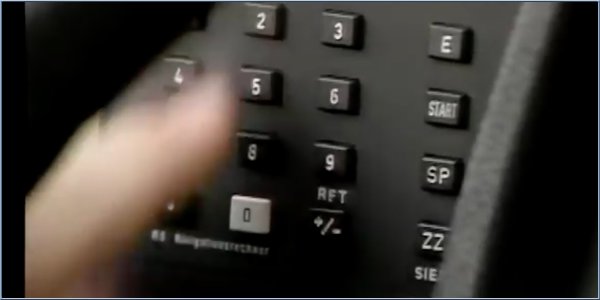
Using it was simplicity itself, all you needed was a special paper map, divided into grids, from which you get code for your start addresses is in, the code for the address of your destination and codes from the reference book for your start and end addresses, that you find in the map codes booklet. Armed with all that you could input the data into the cars nav system and be guided to your destination. Easy peasy.
The system used magnets to sense the earths magnetic fields and guide you, the instrument panel had a simple arrow display, it had no concept of roads so it was 'as the crow flies' with the actual route decided by you.
Now go and thank the inventors of GPS for the system that prevailed or this might have been the solution we ended up with! The full video is available via the link below, FFWD to 21:48 for the nav segment.
Source: YouTube
| | |  |
| Comments
|
 Posted by rkm_hm on Thu Apr 07, 2016 12:45 pm Posted by rkm_hm on Thu Apr 07, 2016 12:45 pm |
 |
The video didn't actually say how it worked - apart from using the earth's magnetic field and magnetic sensors.
My hunch is that it just used a compass to determine the direction of travel, and combined that with a speed reading to work out where you were at any given time.
I don't think it knew where you were in absolute terms because you had to tell it the coordinates of the starting point before it could point you at your destination.
Seems pretty archaic compared with modern GPS-based systems, although it was doubtless better than nothing. Having said that, aircraft had been using inertial navigation systems for a long time prior to that - but this system doesn't claim to be one of those.
Roger
TomTom via135
Satmap Active 10+ v1.50 with full UK 1:50k map and 1:25k/1:10k County maps of Hampshire & Warwickshire |
|
| Posted by Darren on Thu Apr 07, 2016 1:11 pm |
|
Indeed that's the point, it is just an inertial system hence the need to manually enter your starting point. I did try and look up further info, apart from a mention that it required a number of magnetic sensors there was precious little detail sadly 
Darren Griffin |
|
| Posted by rkm_hm on Thu Apr 07, 2016 1:49 pm |
|
| Darren Wrote: | | Indeed that's the point, it is just an inertial system hence the need to manually enter your starting point. I did try and look up further info, apart from a mention that it required a number of magnetic sensors there was precious little detail sadly |
But I don't think it WAS an inertial system - I think it was cruder than that. Aircraft inertial systems used a gyro-stabilised platform with accelerometers on each of the 3 axes - whose output was double-integrated in order to calculate position. I'm not aware that they used magnetic sensors.
I suspect that the system in the video just used direction - from a compass - and speed - from the vehicle system. I can't quite work out why it would need multiple magnetic sensors. As far as I'm aware, you can't work out absolute position from the earth's magnetic field - just which way North is. But I might be missing something!
Roger
TomTom via135
Satmap Active 10+ v1.50 with full UK 1:50k map and 1:25k/1:10k County maps of Hampshire & Warwickshire |
|
| Posted by moonseeker on Fri Apr 08, 2016 8:36 am |
|
And there were those of us 'early adopters' who used in-car navigation with a handheld (Garmin) GPS before in-car GPS was available.
This involved loading up OS maps on a laptop, finding the destination, downloading this to the Garmin, and then fixing the Garmin to the dashboard with velcro.
It would give you two things:
(a) A count-down to your destination in miles,
(b) A pointer which pointed in the direction of your destination.
You then set off in the direction the indicator was pointing, and keeping an eye on the 'miles-to-go' count
If:
(a) The count kept going down -- you were going the right way
(b) The count increased -- you were moving away from your destination
(c) The count remained constant -- you were going in a big circle.
In practice it is was surprisingly accurate, and at the same time amazed your passengers with your obvious brilliance!
|
|
| Posted by rkm_hm on Fri Apr 08, 2016 9:30 am |
|
| moonseeker Wrote: | And there were those of us 'early adopters' who used in-car navigation with a handheld (Garmin) GPS before in-car GPS was available.
This involved loading up OS maps on a laptop, finding the destination, downloading this to the Garmin, and then fixing the Garmin to the dashboard with velcro.
|
I did something akin to that - but it was just displaying my current position on a map on a laptop - not actually providing guidance. So I had to plan my own route, and the laptop plus GPS provided reassurance that I was going the right way. Or if I was just driving around, sightseeing, it would show me where I had ended up, on the map.
It was in the days when the US military still introduced systematic errors into the GPS signal, and the system was dumb and had no 'snap to road' facility - or even any knowledge of where roads were - so I often appeared to be driving through a field in a direction parallel to the road I was actually on!
Roger
TomTom via135
Satmap Active 10+ v1.50 with full UK 1:50k map and 1:25k/1:10k County maps of Hampshire & Warwickshire |
|
|
|
 |
|
|
 |
 |
 |
 |
|
|


