|
|
 |
 |
 |
 |
Google Maps gets offline navigation and search
Article by: Darren Griffin
Date: 12 Nov 2015
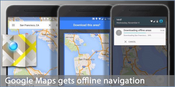
Google has added offline navigation and search to its map app. This much sought after feature means you can now download an area of interest and Google Maps will continue to work regardless of connectivity. Much though we wish it were not true, there are still large areas where data connectivity is patchy or non-existent and this will also benefit those of you wishing to use it whilst abroad and roaming.
Offline map viewing is not new of course, this feature has been available for a long time. But the addition of off-line search and navigation is the game-changer here and that makes offline access a great deal more useful.
Downloading a map area is easy and the app will automatically switch to an offline map if connectivity is lost. Download is enabled for WiFi only by default to avoid any data usage fees or penalties.
The update is rolling out to Android users now and coming to iOS soon.
Source: googleblog
| | |  |
| Comments
|
 Posted by rkm_hm on Thu Nov 12, 2015 10:40 am Posted by rkm_hm on Thu Nov 12, 2015 10:40 am |
 |
Presumably it will be possible to get CamAlert to run Google Maps at the same time as itself - as for other navigation apps?
If so, how about taking the next step and doing a proper integration so that the camera positions can be seen on the map - like they can on dedicated PNDs?
Roger
TomTom via135
Satmap Active 10+ v1.50 with full UK 1:50k map and 1:25k/1:10k County maps of Hampshire & Warwickshire |
|
| Posted by Bunty1948 on Thu Nov 12, 2015 10:59 am |
|
| rkm_hm Wrote: | Presumably it will be possible to get CamAlert to run Google Maps at the same time as itself - as for other navigation apps?
If so, how about taking the next step and doing a proper integration so that the camera positions can be seen on the map - like they can on dedicated PNDs? |
No that would be really good especially for those of us with tablets and the latest TT devices that can't accept the database as POIs.
I'd even pay for that.
|
|
| Posted by rkm_hm on Thu Nov 12, 2015 11:14 am |
|
| Bunty1948 Wrote: | | rkm_hm Wrote: | Presumably it will be possible to get CamAlert to run Google Maps at the same time as itself - as for other navigation apps?
If so, how about taking the next step and doing a proper integration so that the camera positions can be seen on the map - like they can on dedicated PNDs? |
No that would be really good especially for those of us with tablets and the latest TT devices that can't accept the database as POIs.
I'd even pay for that. |
I assume that your first work should be "Now"?
This would indeed be good. With people able to use a wide variety of nav apps with CamAlert, it obviously wouldn't be practical to integrate all of them. But, with a mainstream app like Google Maps, I would like to think that a case could be made for integrating this one.
Roger
TomTom via135
Satmap Active 10+ v1.50 with full UK 1:50k map and 1:25k/1:10k County maps of Hampshire & Warwickshire |
|
| Posted by Calomax on Fri Nov 13, 2015 10:35 pm |
|
In Autumn 2014 while visiting the UK, I tried out navigation on Google Maps and it worked well even though I had data turned off as I was roaming, although the instructions weren't as pleasant as TomTom's Tim.
This year I was visiting again but couldn't get Google Maps at all unless I was in a wifi hotspot. I now know that I can download maps but I'd like to know why I could get the maps without downloading or having data enabled 14 months ago.
TT Go Essential |
|
| Posted by rkm_hm on Fri Nov 13, 2015 11:02 pm |
|
| Calomax Wrote: | In Autumn 2014 while visiting the UK, I tried out navigation on Google Maps and it worked well even though I had data turned off as I was roaming, although the instructions weren't as pleasant as TomTom's Tim.
This year I was visiting again but couldn't get Google Maps at all unless I was in a wifi hotspot. I now know that I can download maps but I'd like to know why I could get the maps without downloading or having data enabled 14 months ago. |
I'm afraid that I can't explain that. In my experience, you've always needed an internet connection to get any real-time map functions - although there has long been the ability to download map segments for off-line use.
I don't know how this new navigation facility (turn by turn voice commands with off-line maps) is being rolled out. I've just updated my Android tablet to the latest version of Google Maps offered to me - and it doesn't have that facility. Also, it seems to me that to make it work decently, the method of downloading maps will need to change. At the moment, you can only download a smallish area at a time - with a span of 20 miles or so. If you try to do more, it says area too large and tells you to zoom in to a smaller area. By contrast, the Here app allows you to download the whole of England in one go.
Roger
TomTom via135
Satmap Active 10+ v1.50 with full UK 1:50k map and 1:25k/1:10k County maps of Hampshire & Warwickshire |
|
| Posted by M8TJT on Fri Nov 13, 2015 11:23 pm |
|
| rkm_hm Wrote: | | I assume that your first work should be "Now"? |
And I assume that you really meant "I assume that your first word should be "Now"?"
|
|
| Posted by rkm_hm on Sat Nov 14, 2015 9:27 am |
|
| M8TJT Wrote: | | rkm_hm Wrote: | | I assume that your first work should be "Now"? |
And I assume that you really meant "I assume that your first word should be "Now"?" |
Indeed. Fair cop, Guv!
Roger
TomTom via135
Satmap Active 10+ v1.50 with full UK 1:50k map and 1:25k/1:10k County maps of Hampshire & Warwickshire |
|
| Posted by M8TJT on Sat Nov 14, 2015 11:24 am |
|
| General Dreedle, Catch 22 Wrote: | | Take him out and shoot him |

|
|
| Posted by IanS100 on Sat Nov 14, 2015 12:14 pm |
|
It seems Google have raised the size of downloadable tiles, rather than having to download a whole raft of little tiles to cover the North West, I've been able to download Stoke to Penrith x Liverpool to Leeds as one huge tile 
Galaxy Note 4 / TomTom GO : CamerAlert : CoPilot |
|
| Posted by rkm_hm on Sat Nov 14, 2015 6:09 pm |
|
| IanS100 Wrote: | | It seems Google have raised the size of downloadable tiles, rather than having to download a whole raft of little tiles to cover the North West, I've been able to download Stoke to Penrith x Liverpool to Leeds as one huge tile |
Interesting! If I tap the Tips & Tricks option in the Google Maps app on my android tablet it opens a browser and takes me to an online document about downloading maps for offline use.
This says "This article applies to iOS devices" and provides a link to the equivalent Android article. Among other things, the iOS article says "The biggest size for an offline map is 50km x 50km"
HOWEVER, when I switch to the Android article, THAT says "The biggest size for an offline area is 120,000 square kilometers" which, if square, would equate to about 350km x 350km - a far cry from the 50km mentioned above.
NEVERTHELESS, when I try to save a map on my Android device, it won't let me save anything that is more than about 30 miles in scope.
I suppose that the on-line article might be referring to a different version of the app from the one I'm using - but I updated mine only yesterday and thus assume it to be the latest version.
Anyone got any comments?
Roger
TomTom via135
Satmap Active 10+ v1.50 with full UK 1:50k map and 1:25k/1:10k County maps of Hampshire & Warwickshire |
|
| Posted by JockTamsonsBairn on Sat Nov 14, 2015 7:01 pm |
|
| rkm_hm Wrote: | | Anyone got any comments? |
Nexus 6
Maps v9.17.1 Updated 13 Nov 2015
I don't see a download option.
Jock
TomTom Go 940 LIVE (9.510, Europe v915.5074 on SD & 8.371, WCE v875.3613 on board) |
|
|
| Click here to view more comments... |
|
 |
|
|
 |
 |
 |
 |
|
|


