Hi! We see you’re using an ad-blocker. We’re fine with that and won’t stop you visiting the site.
But as we’re losing ad-revenue from this then why not make a donation towards website running costs?. Or you could disable your ad-blocker for this site. We think you’ll find our adverts are not overbearing!
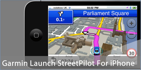
Most SatNav companies have some form of SmartPhone solution with the exception of Garmin. Well earlier this year Garmin introduced StreetPilot for iPhone and iPad in the US Apple AppStore, and now a newer and better UK version of the app is soon to be released in Apple's UK AppStore.
Historically Garmin have had a number of forays into the SmartPhone market, but either the market was not ready or Garmin's products did not meet the market requirements of the time. Whilst the Garmin PNDs thrived the mobile side of the business struggled. This seems about to change as Garmin now have a mobile app running on the Apple iPhone/iPad platform that takes their PND application functionality into the SmartPhone arena.
We spent the morning with Clive Taylor Garmin's Director of Product Development, who showed us the new StreetPilot software for Apple iPhone in action and explained a little about Garmin's policy in the SmartPhone market. Read on to find out about Garmin's entry in to the UK iPhone market, and to watch our 'first look' video…
Garmin have tried to enter the mobile market in a number of different ways with Android, Microsoft and Blackberry devices. The Android attempt was effectively an effort to produce a customised Android Phone based around Garmin Navigation as part of the early Android Alliance in conjunction with Asus. The Asus alliance also produced two Windows Mobile devices, but these initiatives were both late to market and never really caught on.
The Blackberry attempt saw Garmin introduce off-board navigation. This trend is quite big in the USA, but it is carrier led and as far as I am aware no navigation company has been successful introducing off-board navigation in its own right. Whilst the application worked OK it really was not up to the normal Garmin standard (different User Interface) and was also hampered by the hardware. Although Blackberry has a large installed base the application was not compatible with the more popular Windows Mobile, Apple, Android or Nokia devices.
Last year Garmin once again tried to bring an off-board mapping solution to the SmartPhone market in the USA, and is now having some success with the iPhone application currently sitting at 11th in the Navigation category. However things are different in Europe! Having learnt the lesson that users do not like relying on a data connection for map data Garmin has now evolved it's StreetPilot software and produced an application with integral on-board mapping.
Not only do we have onboard maps, but the application has a similar user interface to the Garmin PNDs. Garmin have invested a great deal of time and effort perfecting the user interface so it makes sense that the new StreetPilot app should adopt this. In fact the User Interface is so similar to the current range of PNDs that anyone who has used a Garmin PND will feel right at home with the new iPhone App. There are a few tweaks which make access to some functions a bit easier, but on the whole it is a normal Garmin experience.
The application has all the features that we have come to expect with SatNav but as it is on an iPhone there is an option to navigate to a contact from the iPhone's contact database. One neat feature that is very subtle is the PhotoReal Junction View. This is an actual picture of the junction with the lane assistance indicators drawn on top. I looked at all the junctions that I passed and indeed they do actually show the real images of the intersections.
Last week we met with Anthony Chmarny from Garmin's PR department who was telling us about the importance of the connected devices in the PND market. Obviously a SmartPhone has a data connection and thus is connected and able to access data over the Internet. This is one of the strong points of the iPhone application and allows Garmin to provide traffic and other dynamic content to the user. This makes a lot of sense and fits in nicely with the European modus operandi of onboard data and connected additional services.
Garmin's Traffic data is currently provided TrafficMaster and will be available as an in-app purchase either on a monthly or annual recurring basis. Garmin are continually seeking to improve the traffic data provided to the application. When and if this does transpire it will take place transparently on the Traffic data feed and all subscribed users will gain access to the enhanced data.
One key feature of the traffic information is access to various traffic cameras operated by the Highways Agency. One of the main criticisms of traffic data is the reality of the reports. There is often little confidence that the reported traffic issues are actually there. Well with live traffic cameras you can actually see if there are the reported jams on your route.
Another Garmin iPhone application is the Garmin Tracker. This allows authorised users to find out where you are. In fact Garmin Tracker integrates a number of different connected Garmin devices allowing anyone with the Garmin Tracker iPhone app, or access to a web browser, the ability to determine where these devices are. Devices supported are nuLink PNDs, the Garmin GTU 10 personal tracking device but not currently the new iPhone StreetPilot App...
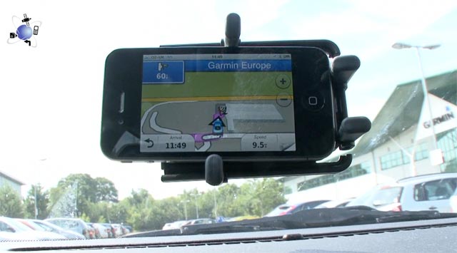
Our video shows the iPhone application in action on a short trip near Garmin's UK headquarters in Southampton. We will be producing a full review of the app when it becomes available in the Apple AppStore later.
As some of you may be aware Garmin recently purchased the rival navigation company Navigon. With the Garmin StreetPilot entry into the market there are obviously questions about what will happen with the two applications. From what I understand nothing has been decided yet, but it does make sense to have a single development team with a single application leveraging the best functionality of both systems. It would also make sense for Garmin to see how well the StreetPilot application fares before determining the fate of the competing applications. It really will be a case of watch this space to see how things pan out in the next few months.
Comments
Posted by MikeB on Tue Aug 02, 2011 9:19 am
The StreetPilot app should be in the Apple App store in the next few hours.
Mike Barrett
Posted by Darren on Tue Aug 02, 2011 10:11 am
This has been a long time coming but good to see that Garmin have finally given up on the fools errand that was their nüvifone and concentrate on offering their software as an app for everyone instead.
Surprised that we haven't seen any news of an Android version yet, especially as it seems reasonable to assume that much of the code is already available because of the nüvifone project?
Darren Griffin
Posted by geraint on Tue Aug 02, 2011 11:03 am
I already have TomTom on my iPhone which works really well. It's major downsides (in my opinion) are its out-of-date maps and the fact that I can't use the PocketGPSWorld safety camera database with it.
For me to pay Ł44.99 for StreetPilot (listed as "Garmin UK & Ireland" in the iTunes AppStore), I'd like to see a full review of it so that I can determine if it's worth the money.
How up-to-date are the maps?
How frequently do maps get updated?
Will I have to pay for map updates?
Will I have to pay for app updates when they're available?
How long will Garmin support this app for? Your article hints at a history of moving on to new projects...
Does it support UK 7-character postcodes?
How well does the "navigate to contact" work?
Can I create my own POIs?
Can I use the PocketGPSWorld safety camera database with it?
Geraint
TomTom for iPhone v1.9
App version: 8.300 (777309)
Map: Western Europe v875.3668
Posted by Darren on Tue Aug 02, 2011 11:10 am
We will of course be reviewing it in due course but I can answer the PGPS Database issue, that'd be a yes, just use CamerAlert
Darren Griffin
Posted by Andy_P on Tue Aug 02, 2011 11:25 am
News Team Wrote:
One key feature of the traffic information is access to various traffic cameras operated by the Highways Agency.
So the UK Highways Agency now have cameras on the US Interstate I-35 into Kansas???? Big Brother really *is* watching!
"Settling in nicely" ;-)
Posted by Darren on Tue Aug 02, 2011 11:35 am
That screenshot demonstrates Tracking, not traffic cameras Andy.
Darren Griffin
Posted by mikealder on Tue Aug 02, 2011 2:07 pm
Anyone know what range the Traffic data is displayed and acted upon by the software? - Mike
Posted by zebsogo on Tue Aug 02, 2011 3:27 pm
I was shocked, surprised and fearful when i heard that Garmin had purchased Navigon. I have a Navigon app for the iPhone and an 8450 standalone. I bought a Standalone Nuvi 1690 a few months ago mainly out of curiosity and for the live traffic. I sold it quite quickly as i found the routing to be woefully poor. I for one will not be buying this app for my phone I do not want to assist or have a hand in the demise of the navigon app
--
Navigon 92 Premium Live,TomTom Go 6000,Garmin 2699 LTM-D and a TomTom Go 1005 Live ( For the wife )
Posted by mikealder on Tue Aug 02, 2011 3:47 pm
Ł44:99 for UK&ROI but it takes up 804MB of storage space which seems a huge amount for what is a regional only map.
Ł2:99 for the "in app" purchase of Traffic - Mike
Posted by MaFt on Tue Aug 02, 2011 4:16 pm
mikealder Wrote:
Ł44:99 for UK&ROI but it takes up 804MB of storage space which seems a huge amount for what is a regional only map.
Ł2:99 for the "in app" purchase of Traffic - Mike
it seems to have a full world base-map. the default favourites include eifel tower and statue of liberty - if you view those you get all the base maps around them too... that could be the reason for some of the space?
Ł2.99 is per month or Ł21.99 per year for traffic.
they also do a yearly sub for traffic too.
not played with it much but the look and ease of use are very good. the TTS voice sounds a bit poor though
MaFt
Posted by MikeB on Wed Aug 03, 2011 9:26 am
mikealder Wrote:
Ł44:99 for UK&ROI but it takes up 804MB of storage space which seems a huge amount for what is a regional only map.
Ł2:99 for the "in app" purchase of Traffic - Mike
A lot of the space is for the 3D features of the POIs and also the PhotoRealistic junctions.
Hi! We see you’re using an ad-blocker. We’re fine with that and won’t stop you visiting the site.
But as we’re losing ad-revenue from this then why not make a donation towards website running costs?. Or you could disable your ad-blocker for this site. We think you’ll find our adverts are not overbearing!