|
|
 |
 |
 |
 |
First Demonstration Of A Galileo Enabled Autonomous Vehicle
Article by: Darren Griffin
Date: 29 Nov 2019
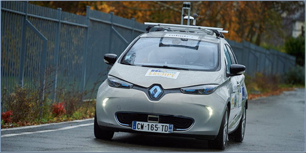
A French University has demonstrated the first autonomous vehicle powered by Galileo.
In a world first, the Renault ZOE electric car can autonomously drive along public roads using Galileo signals and the ESCAPE GNSS engine (EGE), funded by the European GNSS Agency.
The EGE prototype design includes several major components, including a novel multi-frequency, multi-constellation automotive-grade GNSS receiver. The main distinguishing feature of the ESCAPE receiver is its ability to precisely and simultaneously process signals from two different GNSS bands and from different satellite constellations.
The receiver is also a first-of-a-kind device in its segment to support the new Navigation Message Authentication (NMA) service of Galileo - the open E1 signal.
Source: gas.europa.eu
| |  |
| Comments
|
 Posted by boltysan on Fri Nov 29, 2019 9:10 am Posted by boltysan on Fri Nov 29, 2019 9:10 am |
 |
Just curious, what is an “automotive-grade GNSS receiver.” Is this different to one that is built into a phone or is it simply one that isn’t as accurate as what the military might have?
|
|
| Posted by Gurubarry on Fri Nov 29, 2019 10:24 am |
|
I live in the mountains near Carcassonne , and the GPS signals and phone relays are always dropping out ...hope the car is supplied with good air bags if it goes into the deserted areas of France .
Don't Take Life too Seriously-You'll Never Get Out Alive |
|
| Posted by M8TJT on Fri Nov 29, 2019 2:46 pm |
|
@boltysan.
| Quote: | GNSS
GNSS stands for Global Navigation Satellite System, and is the standard generic term for satellite navigation systems that provide autonomous geo-spatial positioning with global coverage. This term includes e.g. the GPS, GLONASS, Galileo, Beidou and other regional systems. GNSS is a term used worldwide The advantage to having access to multiple satellites is accuracy, redundancy and availability at all times. Though satellite systems don't often fail, if one fails GNSS receivers can pick up signals from other systems. Also if line of sight is obstructed, having access to multiple satellites is also a benefit. Common GNSS Systems are GPS, GLONASS, Galileo, Beidou and other regional systems.
GPS
The United States' Global Positioning System (GPS) consists of up to 32 medium Earth orbit satellites in six different orbital planes, with the exact number of satellites varying as older satellites are retired and replaced. Operational since 1978 and globally available since 1994, GPS is currently the world's most utilized satellite navigation system.
GNSS/GPS applications include:
Tracking/Mapping Devices
Industrial Machinery
Sea vessels
Air Navigation
Automobiles |
From HERE But you are probably referring to the Automotive grade bit, and who knows?
|
|
| Posted by Kremmen on Fri Nov 29, 2019 2:49 pm |
|
I do hope all those visible scanners on that car stay clean.
Lets be careful out there ! |
|
| Posted by Tangsoodogb on Fri Nov 29, 2019 2:53 pm |
|
What happens when the car goes into a tunnel, or multi-storey car park, and loses all gps signals???
Satnavs:Tomtom Go1005 Live.
Ancient Go700. |
|
| Posted by M8TJT on Fri Nov 29, 2019 4:05 pm |
|
Or when everyone plugs their electric cars ion at the same time and the lights go out.
|
|
| Posted by Fellwalker on Fri Nov 29, 2019 5:16 pm |
|
| M8TJT Wrote: | | Or when everyone plugs their electric cars ion at the same time and the lights go out. |
Hopefully not while they are driving 
Samsung Galaxy Note 9, Nexus 5, Galaxy tab S3. Also use OSMAnd+, Sygic Mobile Maps, and OS maps app. Also "Great Britain Topo Maps" and "Old Maps". Don't use speed camera database as sticking to the limit is safer. |
|
|
|
 |
|
|
 |
 |
 |
 |
|
|


