|
|
 |
 |
 |
 |
Blue Motorways Return Sort Of
Article by: maft
Date: 19 Feb 2014
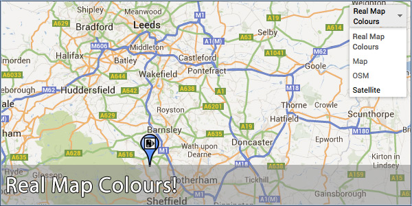
Back in August last year I had a bit of a moan about Google changing their mapping colour scheme to predominantly orange. It still annoys me to this day when I'm managing the speed camera submissions; a submission on an orange road means I have to zoom out and see if it's an A road or a motorway to validate the speed - it was so much easier when motorways were blue and A roads were green.
If, like me, you still long for the days when the submission maps used nationally recognised colours for their roads then rejoice with me for your days of longing are over! Sadly, Google have not officially returned the proper colours but, with a bit of jiggery-pokery (and the great idea of Optimap by Mark Groodge) we now have real map colours back on the POI and Speed Camera submission maps! Real colours are selected by default but you can easily change to the Google-Orange scheme by selecting 'Map' in the top right.
| | |  |
| Comments
|
 Posted by M8TJT on Wed Feb 19, 2014 11:15 pm Posted by M8TJT on Wed Feb 19, 2014 11:15 pm |
 |
TFFT. It's great to see the 'proper' colours back. What on earth were Google thinking about when they changed the colours. Shame that you can't do it on the Google maps ordinaire.
|
|
| Posted by K13ehr on Fri Feb 21, 2014 8:52 am |
|
Nice to have a local map for a change when illustrating a map.
Not that there London area one :D :D
Thanks Maft
|
|
| Posted by K13ehr on Fri Feb 21, 2014 8:55 am |
|
| M8TJT Wrote: | | TFFT. It's great to see the 'proper' colours back. What on earth were Google thinking about when they changed the colours. Shame that you can't do it on the Google maps ordinaire. |
The new Google maps is awful, it was just about perfick before, so some overpaid swine with nothing better to do, messes it all up, not all progress is good, I still haven't figured out how to get rid of all the on screen junk top left so you can see all of the map like wot we used to be able to do like.
|
|
| Posted by Anita on Fri Feb 21, 2014 9:24 am |
|
Absolutely agree, Kev. Hate the rubbish that now obscures parts of the map.
I can't find a way to drop a lat/long marker either. It was so easy before - right click where you wanted it and select 'Drop lat/long marker'. 
Anita
TomTom VIA 135 - App 12.075
UK map 1130.12368
Samsung Galaxy S21 |
|
| Posted by MaFt on Fri Feb 21, 2014 9:47 am |
|
| K13ehr Wrote: | Nice to have a local map for a change when illustrating a map.
Not that there London area one :D :D
Thanks MaFt |
I always use local areas when I post news about mapping :D Just need to fit Heckmondwike in one day - I just love the name of that town :D
MaFt
|
|
| Posted by K13ehr on Fri Feb 21, 2014 12:34 pm |
|
I always liked CleckHuddersFax :D :D
|
|
| Posted by Fellwalker on Fri Feb 21, 2014 12:39 pm |
|
Proper colours include Blue for Motorways, Green for Primary routes (formerly known as Trunk Roads), RED for A roads, Yellow for B roads, and white for others. That is what my Ordnance Survey road atlas uses (even more colours in 1:50,000 but that might be too difficult).
To me, that means the so-called proper colours are still wrong. Perhaps Google does not differentiate trunk and A so they are all green. Personally, I'd prefer red for all A roads if they all have to be the same.
OpenStreetMap for me then. At least it shows PROPER colours.
Samsung Galaxy Note 9, Nexus 5, Galaxy tab S3. Also use OSMAnd+, Sygic Mobile Maps, and OS maps app. Also "Great Britain Topo Maps" and "Old Maps". Don't use speed camera database as sticking to the limit is safer. |
|
| Posted by MaFt on Fri Feb 21, 2014 1:19 pm |
|
| Fellwalker Wrote: | | OpenStreetMap for me then. At least it shows PROPER colours. |
Hugely tempted now to change our OSM source tiles to something completely garish ;) 
|
|
| Posted by Wazza_G on Sat Feb 22, 2014 1:26 pm |
|
Fellwalker has it spot on and Optimap has it wrong as well.
Best solution is use Bing maps & select OS. 
Be alert.. This country needs more lerts. |
|
|
| Click here to view more comments... |
|
 |
|
|
 |
 |
 |
 |
|
|


