|
Sygic Mobile 2009 Review |
1st April 2009 |
|
Review by Matthew Morley (MaFt)
Shortcuts: Introduction | In The Box | Installation | Main Menu | Choosing a Destination | Navigation |
Speed Cameras & POIs | Itinerary | Screen Orientation & Standby | Extras | Round Up | Conclusion | Links

Introduction
With more and more people getting fed up with the lack of updates (both software and maps) for TomTom Navigator we thought it was about time we reviewed another option available to you the customer! So here we have the PocketGPSWorld.com review of Sygic Mobile 2009 – the company behind TeleAtlas' (TomTom's) McGuider software.
In the Box
Sygic Mobile 2009 comes on a pre-installed micro-SD (transflash) card with adaptors for both mini and full-size SD included and also comes with Windows software for adding/removing voices and map regions. The pre-installed mapping covers Western and Eastern Europe but if you need more space on the memory card then map regions can easily be removed.
Installation
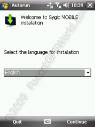
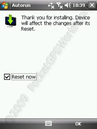 Sygic Mobile 2009 is compatible with a range of Smart Phones (touchscreen and non-touchscreen )and PDAs but not Blackberry. This review is based on my experience using a T-Mobile MDA Compact III – not the fastest phone but, as you will see, perfectly adequate for the software! Installation was quick and easy but did require a reboot of the PDA which, to be honest, wasn't a major deal!
On the first run you are taken through the standard set up screens of choosing your language, region, unit preferences etc and then you get to the main screen...
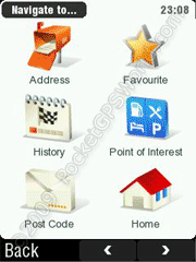
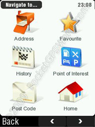
 Main Menu
Menu navigation is either by touchscreen (simply press what you want) or by using your device's hardware buttons. As soon as you press any directional hardware button then numbers are shown on the menu as shown to the left. You could then press '4' on a non-touchscreen smart phone to jump to option 4.
To get to the main menu from the map screen simply touch the map area on the screen (or press the left hardware button). The menu options should be instantly recognisable as the majority match a certain red-handed company's software...! The icons are descriptive in themselves and the menu structure is easy to follow.
Choosing a Destination
Pressing 'Navigate to' gives you the options of Address, Favourite, History, Point of Interest, Post Code, Home, Point on Map, Enter GPS Position and Last Valid Position. As with the majority of Sygic's user interface, the options are self-explanatory. After selecting 'Address' it's a long way to scroll down to get to United Kingdom or you can select 'Show' to display the keyboard and start typing the country. Thankfully Sygic remembers your last selected country and has this selected as the default. For city and street selection the most recent selections are shown initially but when you start typing these are replaced with cities that match your input. Finally you can input a house number, junction or choose 'Any' which simply navigates you to the nearest part of the road you requested.
 When searching by 'Point of Interest' you can choose where to search: Near my position, Near address, Near destination or POI in City. The built in POIs are the standard TeleAtlas ones which, in all honesty, aren't that great. However, you can add your own POIs by using a downloadable program to convert OV2 files to Sygic's UPI format.
If you choose to navigate directly to a postcode then there is no option for choosing the house number afterwards. This is a fairly annoying limitation especially when the address you want is in a rural area!
The other 'Navigate to' options are self-explanatory so I won't go into any detail on those. Once your destination is set you are shown the destination (address or co-ordinates etc) as confirmation along with six options: Call (if it is a POI with a phone number you can call them directly from within Sygic), On Map (view destination on the map), Parking (find parking POIs nearby and subsequently navigate to that instead), Add to favourites, Cancel and Route Me!
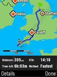
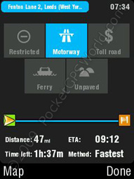 Route calculation is adequate on the test device – which to be honest isn't the fastest out there! It took about 6 minutes to calculate the 395 miles from Bradford to Lands' End but obviously this is an extreme case! The 56 mile route from Bradford to Manchester Airport took about 1 minute but these times aren't be helped by a low-spec device!* You are warned about toll roads, ferry crossings etc on the route and asked to confirm whether you want to accept or ignore those routes – the actual warnings can be changed in the settings.
*UPDATE: Clearing some junk from the phone and freeing up some memory made the Bradford to Lands' End route calculation a more respectable 3m45s and the Bradford-Manchester Airport took 30s. I can well imagine these times would be further decreased on a more modern / higher spec device.
Navigation
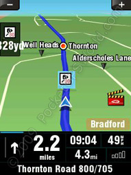
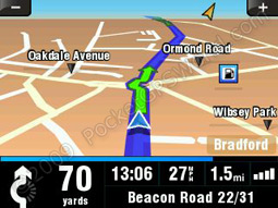
The map screen is clear and contains a lot of information although you cannot change the colours used - a yellow motorway just doesn't seem right! The bottom right panel is customisable and you can select items such as current time, time to destination, GPS signal strength, current speed, average speed etc. Sygic Mobile 2009 utilises a very good auto-zoom – at higher speeds it zooms out to allow you to see further ahead. You can also press and hold the +/- buttons on the touchscreen or use hardware buttons (up/down or left/right) to zoom in or out.
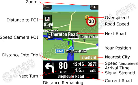
The routes picked by Sygic Mobile 2009 seem sensible and I'm yet to be guided down a regular fly-tipping haunt (as with some very early versions of Sygic Drive!). Lane assistance is a handy feature with the required lane being highlighted in green. Sygic Mobile 2009 also shows sign posts on motorways and some A-roads as a quick confirmation you are on the right track and allowing you to get into the correct lane easier. Driving along the M62 from Leeds to Bradford the signs are very accurate.
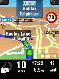
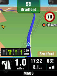
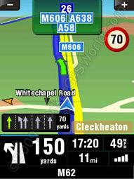
The next turn indicator on the bottom left of the screen is very easy to read at a quick glance and the name of the next road you turn onto is shown on the actual map, highlighted in a grey box (Rooley Lane in the example above).
The current road, along with approximate house numbers, is shown at the base of the screen and the current road speed is shown on the map itself. Should you stray over the speed limit a yellow exclamation mark will be shown along with a warning sound (if set up).
Voice directions are clear but there is only one voice per language which is male for English. Whilst you can add or remove voices via the bundled software there are no extra voices beyond what comes pre-installed on the memory card. Perhaps this is something they will be adding to the software in future versions? It is worth pointing out that there is no Text-to-Speech available although it does say the road numbers. This can be quite annoying though, particularly with longer road numbers when you end up with a command of "Turn right onto B six thousand one hundred and forty five" and there is no way to disable this feature. 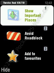 The commands themselves are given in good time and, coupled with the next turn icon (arrows) and lane guidance makes it quite difficult to miss a turn. If you do, however, manage to stuff things up then route recalculation is nice and speedy although there is no audible notification that the software is recalculating the route (some people like this, some people don't!). If, like me, you occasionally know a better route, or just fancy a change, then you can go off route and it will attempt to get you back on the original route three times before giving you the alternative route.
During navigation you can also request an alternative route (or revert back to the original route) as well as redirect for a certain distance to get around road blocks or traffic jams. Pressing the turn arrow during navigation repeats the next instruction and pressing anywhere else on the bottom panel takes you to a screen where you can 'Show Important Places', 'Avoid Roadbloack' or 'Add to favourites'. 'Show Important Places' lists POIs (the actual categories shown are user configurable) in your vicinity along with the option for Sygic to route you to them.
Speed Camera / POI Warnings
 Sygic comes with with some speed camera data preinstalled but this is not particularly accurate and does not use directional data. You can disable the alerts for these cameras via the 'Radar Warnings' under advanced settings. Thankfully you can add 3rd party speed camera data! As per TomTom there is an option for 'Warn When Near POI' which you set up in a surprisingly similar way. After using Sygic's conversion software to convert Tab-delimited Speed Camera files to UPI files you simply copy them to the memory card then select the appropriate sound for each camera type/speed. Even better is the fact that Sygic Mobile 2009 supports ogg sound files so you can even use the PocketGPSWorld.com voice warning files! Sadly, Sygic Mobile 2009 does not support directional warnings and also treats SPECS (average speed) cameras as individual cameras rather than a 'zone'.
Icons are shown on the map along with a countdown in yards although there appears to be a slight bug in that anything over 99 yards (i.e. 3 digits) doesn't quite fit in the space allocated!
Itinerary
Itineraries are easy to set up. Simply choose your points, set the appropriate ones as start or end and away you go. The software has an option for optimising the route but this is poorly implemented. Optimising a route with various points between Bradford and Leeds took a split-second. My initial thoughts were “Wow! IGO 8 takes far longer!” but I soon realised why... The screen shots below show the 'optimised' route on the left and the route I would have expected (edited manually) on the right.
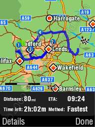
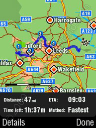
The Sygic 'optimised' route (left) and the MaFt optimised route (right). There's quite a difference...!
 Another flaw in the route optimisation is if you have a circular route (i.e. same place for start and end) it places them both at the beginning of the itinerary – defeating the object of setting one of them as an end point! For further testing I tried moving the end point a few hundred yards (rather than exactly the same as the start point) but it still moved it further up the itinerary. In this case it seems as though the software simply picks the next closest point in the list rather than actually choosing the optimal route between all the points but in the screenshots above you can see that it isn't always the case!
A feature I liked about Sygic Mobile 2009 was the ability to add waypoints to your current route rather than having to initially create the route as an itinerary. Simply go to the itinerary option in the menu while you have a route set and you can then select '[current route]' to add your new waypoints.
 Screen Orientation & Standby
More and more phones are making use of accelerometers and Sygic takes advantage of this. If you have a compatible phone then the display will switch automatically from portrait to landscape as it detects the orientation of the phone. For those with older devices lacking such features it is very quick and easy to change orientation via the settings menu and you don't even need to restart the software. It should also be pointed out that putting the test device into standby also causes no issues (unlike iGO 8 and CoPilot 7).
 Extras
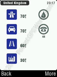
Sygic Mobile 2009 features a handful of extra features such as unit convertor, world clock and calculator. Whilst there is nothing particularly unique with those, the 'extra' that stands out as quite novel is the 'Country info' – simply select any country from the list to find out various bits of information such as road speed limits, country dialling code, currency, population, what side of road to drive on etc. OK, I admit, it's not that useful but still, it's something novel that I'm sure someone, somewhere will use!
Also, within the Settings are 'Quick Guides' which, as the name suggests, are a series of guides that go through the basics of operating the software. Their contents are a bit sparse for more advanced options but would suffice to get you going if you were new to the software.
Round Up
Pros
- Easy to use
- Friendly UI
- Very good map coverage
- Sensible routing
- Clear & timely instructions
Cons
- Itinerary optimisation is poor
- Lack of house number for postcode entry
- No ability to change map colours
- Only one voice per language
Conclusion
Overall I would highly recommend Sygic Mobile 2009; it is nice and responsive, easy to get to grips with (even more so if you are a TomTom user), has a lot of nice features (lane guidance, street signs, proximity alerts) and comes bundled with enough maps to shake a proverbial stick at. The interface is easy to navigate using your fingers (no stylus needed!) and for those without touchscreen devices you can use numbers as shortcuts or simply use the cursor keys.
References & Links:
| Comments
|
 Posted by marc_holmes on Wed Apr 01, 2009 7:15 pm Posted by marc_holmes on Wed Apr 01, 2009 7:15 pm |
 |
What's the difference between
- Sygic Mobile for mobile phones
and
- Sygic Drive for PDA/Pocket PCs
I'm thinking from the point of view of a HTC TyTnII owner.
Marc.
|
|
| Posted by Darren on Wed Apr 01, 2009 7:19 pm |
|
I think Sygic Mobile is designed for handsets that do not have a Touch screen interface. Drive is for devices that do. So a WM PocketPC Phone such as the TyTnII would use Sygic Mobile.
Darren Griffin |
|
| Posted by mikealder on Wed Apr 01, 2009 7:24 pm |
|
Sygic Drive is the touch screen application Tytn-II is touch screen - Mike
|
|
| Posted by marc_holmes on Wed Apr 01, 2009 7:31 pm |
|
OK, so Drive it is.
Next question - how uptodate are the maps?
(so far this is ticking all the boxes to replace the old Tomtom).
|
|
| Posted by MaFt on Thu Apr 02, 2009 8:37 am |
|
sygic drive is the old software.
sygic mobile 2009 is their newest software - the website is quite misleading on this!
sygic mobile 2009, as mentioned in the review, is for windows mobile (touch and non-touch screen), and symbian.
not sure about the map dates - it says 'sygic mobile maps 7.71' but no actual date info. if you give me a road i could check fr you? majority of the maps are teleatlas but they do use other providers mainly for eastern europe.
MaFt
|
|
| Posted by scarymonkey on Thu Apr 02, 2009 11:48 am |
|
The only immediately obvious change from the 7.70 version of Drive supplied with McGuider 2009 is the ability to set a start destination in the itinerary planner (unless I have missed how to do this in MG).
Interesting you list the map version as 7.71 as this seems to be an older version to that supplied with MG as the latest map for that is 7.80 (file creation date 28/1/2009). Of couse the 7.71 could well be the program version. The map version can be found in Settings/About.
I have been asking Sygic for information on where to get the latest version from but unfortunately my requests have fallen on deaf ears.
Vince Marsters |
|
| Posted by scarymonkey on Thu Apr 02, 2009 11:55 am |
|
MaFt,
Forgot to ask. Does the voice alert at roundabouts generally make sense in this version? In MG there is a tendancy for it to miss the minor exits on roundabouts, so a major road being crossed by a minor road will give a voice prompt to take the first exit when going straight on instead of the correct second exit (hope that makes sense).
Vince
Vince Marsters |
|
| Posted by MaFt on Thu Apr 02, 2009 2:35 pm |
|
i don't seem to recall any minor roads being missed at roundabouts but then again i don't remember definately seeing them being in the turn count!!
also, re maps - sorry, it IS 7.80!! 7.71 was program version...
however, if i go to settings / switch map the option is sygic mobile 7.71 (which, looking at it now, is the software version number!)
when the map loads t says "Multimap Sygic 7 loaded"
MaFt
|
|
| Posted by scarymonkey on Thu Apr 02, 2009 2:41 pm |
|
Cheers
I am guessing it is just a program update from McGuider 2009 then and looks like it uses the same map source (hence the same version number). In MG it says Multimap McGuider 2009 loaded and McGuider 2009 for the map description.
Vince Marsters |
|
| Posted by MikeS48 on Thu Apr 02, 2009 5:38 pm |
|
Quote - "This review is based on my experience using a T-Mobile MDA Compact III – not the fastest phone but, as you will see, perfectly adequate for the software!"
This could be good news for me - I have an O2 Orbit which is virtually the same phone as yours - same processor and ROM/RAM...and certainly not fast!
I run MN4 on it, mainly to have the PocketGPS cameras with me at all times, and it's perfectly adequate for that. (I use a Navigon 2150 Max for navigating).
The O2 Orbit isn't on the compatibility list so I emailed Sygic to see if this was because it really wouldn't work, or whether it was just because it's an old phone, and they replied that if it's not on their list, it's not supported. Fair enough, I suppose, but bad news for me as I really like the look of the software.
So if it works on yours, it should work on mine, and I may just buy it.
One thing though MaFt, are route calculations really as slow as you say? I did a quick Bradford to Land's End on my O2 with MN4 and it took 48 seconds, and the M/c Airport trip took 17 seconds. (on the 2150 Max these times were 4 seconds and 3 seconds respectively - which I call fast!).
|
|
| Posted by MaFt on Thu Apr 02, 2009 6:23 pm |
|
| MikeS48 Wrote: | | One thing though MaFt, are route calculations really as slow as you say? I did a quick Bradford to Land's End on my O2 with MN4 and it took 48 seconds, and the M/c Airport trip took 17 seconds. (on the 2150 Max these times were 4 seconds and 3 seconds respectively - which I call fast!). |
route calculations do seem quite slow BUT i'm also short on both program memory and storage memory which probably don't help much... other than the slowish route calculations the software itself is quite nippy - unlike garmin mobile xt which i find unusable at times on this phone...
if i get chance i might clear a load of junk from the phone and try some routes again.
MaFt
|
|
|
| Click here to view more comments... |
|