|
|
 |
 |
 |
 |
|
NAVMAN
SmartPath Trips (TomTom Route Planner) |
22nd December
2001 |
|
Reviewed by Dave Burrows |
|
|
With SmartPath there are two
kinds of software. To try and stay close to the paper maps and to
keep disk usage to a minimum, two mapping programs were created. One
that gives you an atlas style maps
where you might want to go the length or breadth of the country, and one
that gives you A-Z style street maps for a specific city. The two
mapping programs are called Trips (Atlast) and City (A-Z).
Having the two
types of maps split out, sometimes is quite nice, but does hinder you.
Why does it hinder you ? Okay, let me try to explain. SmartPath Trips is one complete map of the whole of the UK, so you can
load the whole map onto your CF card and you've got the whole country in
Atlas form. If you are travelling from the south to the
north, then in most cases you would want an atlas style map, which Trips
gives you. However, if you
are also travelling through town centres then you will also want a street
atlas. Unfortunately the way SmartPath City is configured is that
you load the maps for a particular town or city and cannot plot journeys
between maps. If you were travelling from south
to north and you wanted to jump to a higher zoom level so you see more
than A or B roads on the City software, then you would have to turn off
the GPS Receiver, close Trips, load City, power on the GPS Receiver, and
then load the city map you are at, find your position and continue on your
way. As you can probably understand, this is a nightmare to navigate
through! Other GPS software are now coming with a single map, but
again because of the detail level.
Due to there being two
applications, we've split the review up into two, so you can see what each application
offers from the feature set.
|
|
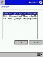
SmartPath Trips gives you
a great feature called Overlays. This is not a new feature to GPS
products, but allows you to overlay particular objects to a map.
For instance, you could overlay airports, parks, stations, even
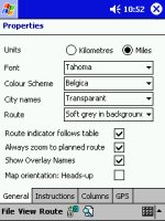
something like speed cameras if you can get your hands on an overlay! You can also see from the Properties
screen that units can be specified in miles or kilometres, fonts and
colour schemes can be changed, how you highlight a route. You can
also change if the GPS pointer follows the map by using Route Indicator,
always zoom to planned route, show overlay names and change the map
orientation depending on whether you want the map to be pointing north. |
  |
|

 |
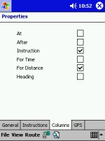
With SmartPath Trips you can change the
level of instructions that you would like to receive.
You can set Trips to tell you after a junction, and tell you to stay on road for 2 miles before
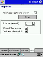
turning right. You can also see the GPS setup screen allowing you
to change the update interval in seconds, and various other GPS settings.
|
|
|
Right you will see the GPS Status screens.
These are the first screens you will need to
go to, to enable you to switch on the GPS Receiver. You have the green
power button, the GPS device name and what COM port it is using,
changing of the format of degrees you want reported and speed settings.
You also have a slider that will stop the Pocket PC going into
snooze/power off mode if it isn't supplied with AC/DC power.
The GPS status screen also shows you your
latitude and longitude in degrees, a car symbol for the speed you are
travelling, and also how many satellites you have a fix on. |

 |
|
  |
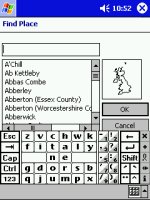
SmartPath Trips will allow you to select
various zoom levels on the map screens, and it also allows you to select which
level of detail you would like to see for Roads, Cities and Districts,
allowing you to tailor the map to your preference.
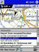
You can also plot routes
from A to B quite effortlessly by selecting A or B roads (some of which
may be listed as Unnamed Small Road), but that doesn't really matter too
much.
If you find you're receiving too much
detail, or the map's looking cluttered or your Pocket PC is running
quite slow when updating the screen, you can always turn the detail level
down.
|
|
Once you have plotted your
chosen map, you can then view it as a map, or directions, or both.
This is a good feature that all mapping software must have, and gives
you total freedom of not only checking where you are, and where the next
turning is on the map, but also verifying this by the instructions it is
giving you.
Some GPS software will also
give you voice navigational aid and journey re-routing, sadly SmartPath Trips and City does not
offer this, but will do shortly in an upgrade destined for August 2002.
|
  |
|
Highs and Low’s
Finally, what is the
software really like to use ? Well it's pretty good. The
worst fact being you have to plan your journey by using either the Trips
or City Maps. Don't think you can
keep both applications open as they will both fight for supremacy over
the GPS receiver, and if you're lucky the one you don't want to use at
that moment in time will be left and the one you wanted will be closed.
In most instances, both applications will be closed.
Apart from this, the only
other downsides is failing to include any voice navigation, map
stitching between city maps. On the other hand, if you haven't
experienced these features in another product, then you won't miss them!
SmartPath Trips and City are very good applications to use, and will
most certainly get you from A to B with the least amount of hassle. |
|
|
 |
 |
 |
 |
|
|


