Review by Peter Bailey
 Introduction Introduction
Pocket FMS is a freeware package available to aviation users for both the PC and Pocket PC.
What a pleasant surprise to find a competent and comprehensive Aviation Navigation System still available as a SHAREWARE download package (a small donation will be appreciated). The development team will stay with the Beta until they are completely happy but expect version 1.0 early 2004.
A visit to PocketFMS.com will quickly introduce you to the scope and content of the software with an excellent demo. which clearly shows how a course is planned together with the major navigation aids and features.
Downloading of the basic program provides a PC planning and mapping system and allows the selection of maps and aeronautical data, downloaded by a further internet visit.
First select required regions (FIR"s) and click on the map section in the internet tab and download. (Data updated every 28 days)
The program and maps can then be transferred to most Pocket PC"s and are compatible with most types of GPS receiver. The planning functions can then be practiced on the PC.

As a prime purpose of the package is to allow for comprehensive, in flight navigation the PDA screens and functions are now illustrated.
When clicking on the Pocket FMS logo the program and data will load and the introductory screen will appear. It is now necessary to click a button or scroll with the center button to view the other screens and to get into action.


To start planning either click the center button to the "flight planning" page or press button 1.
Type in the airport code of your starting point (EGKH, Headcorn), tap "insert leg" and add your destination code (EGSQ, Clacton ). Go to the mapping page, button 3, and your route will be displayed.
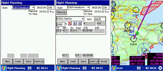
Unfortunately this route passes through a restricted area to the East of Southend (EGMC); not a problem for Pocket FMS.
Simply touch the "avoid" button on the planning screen and a further screen allows you the choice of areas to avoid. Click OK and hey presto an automatic re-route both on the map and in the plan, with additional waypoints, ETE etc. The plan can be saved for future use.

A most impressive, instinctive and practical start with a new piece of software and comforting to find a complete and up to date database of airports, including specific runways and VOR"s .
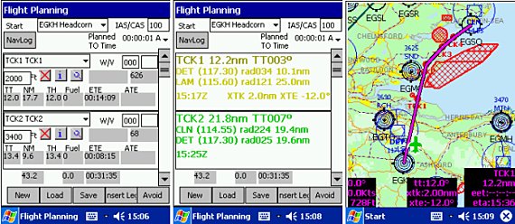
Another useful device is the ability to include "reporting points" i.e. points on the scheduled route when radio calls or other action needs to be reminded. Simply touching and "stretching" the purple plan line will allow another waypoint to be inserted and custom marked as required.
In this case TCK1 (crossing the coast off the Isle of Sheppey) and TCK4 (Advising Clacton of landing intentions) are added to augment TCK3 and TCK3 which were automatically inserted to avid the red restricted area.
These show up on the plan with all the usual references as well as on the map.
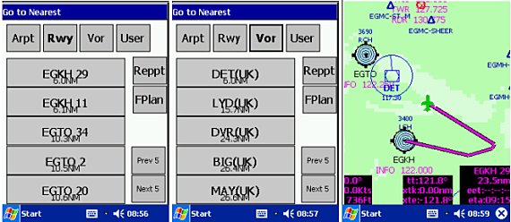
The "nearest runway" feature is always available, button 2, and lists the nearest navigational feature (VOR"s or user made) as well as guiding you into a landing on a specified runway.
 For a great feeling of a professional, integrated approach there are two other pieces of information which would normally be introduced before flying:- For a great feeling of a professional, integrated approach there are two other pieces of information which would normally be introduced before flying:-
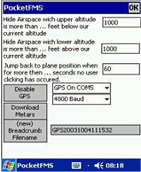
1) Meteorological data.
This can be downloaded directly to the PDA, when docked via Active Sync to obtain interned access via a PC modem link. (Any other internet link, e.g. Via BT and a GMS mobile phone would work)
Simply tap the "Download Metars" button on the "properties window" and wait as the METAR (METeorological Aerodrome report) and TAFS ( Terminal area forecast) data is automatically downloaded for the selected areas of operation.
The Flight planning screen will flag a question as to the inclusion of this data in the plan. The actual flight time scheduled will trigger the appropriate report and adjust for wind vectors.
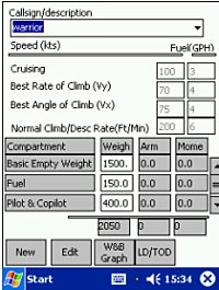
2) Aircraft Information
Aircraft information should be completed for the specific flight together with weights and speeds.
This can be saved to provide a library of planes normally used.
The "planning window" will then automatically include the relevant speeds in the flight plan.
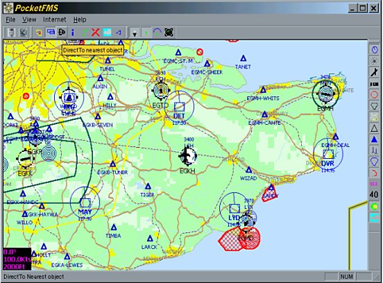
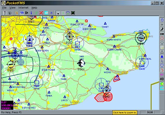
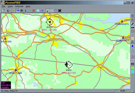
The PC and PDA mapping is clear and bright but quite limited when compared with CAA paper maps. The two magnifications of the PC map are illustrated below and have to be downloaded separately if the coast and road outlines are to be available at both levels of zoom. The detail is the same in both zoom levels.
On the PDA the zoom levels are controlled by tapping the top part of the screen to zoom out and at the bottom to zoom in. Moving the map position is achieved by holding the stylus on the map and moving in the required direction .
Data on direction to next waypoint, distance, ETA etc. is displayed. (This is a static screenshot)
Ideally I would like to be able to zoom out for general data and an un-cluttered screen but be able to zoom in to reveal much more topographical detail and place names. Further aeronautical information, e.g. gliding airfields would also be of benefit.
A scale bar on both PC and PDA would also help.
(I understand from the development team that improved mapping will shortly be available)
Test Flight
On a dull November morning I started by downloading the Metar information via Active Sync and then proceeded to Headcorn airport. The previous flight plan to Clacton was set with current data and avoids.
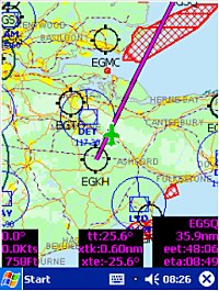
The map page was opened and we proceeded on our flight as illustrated by the following in flight screen shots. (Unfortunately the zoom level auto selected did not show topographical detail and I forgot to adjust it.)

 After takeoff we set a course to pass to the east of Southend airport and advised them of our intentions. After takeoff we set a course to pass to the east of Southend airport and advised them of our intentions.
At TCK2 we altered course towards Clacton and nicely avoided the danger areas. As we approached Clacton a single screen tap increased the zoom level and we made a visual approach to this very short runway. (2000ft).
Pocket FMS was very effective in the general navigation and hazard avoidance, although we did also set our VOR frequencies. The detail of the mapping was the only criticism and we still had to use a 1/500k CAA paper map to verify visual landmarks.
Summary
Pocket FMS in its Beta stage is an exciting piece of navigation software including a variety of features to enhance the safety and enjoyment of private flying. The mapping is uncluttered and quite adequate for normal trips but more detail at the higher zoom levels would be a benefit.
This Shareware system is recommended for testing to all pilots interested in GPS and stands up quite well to some expensive competition.
|


