|
Article by
Dave Burrows
TomTom Navigator has now been
around for a few months, Navman Smart ST Pro has also been around for nearly a
month now, so we thought it about time to bring a head to head comparison
between the two products.
What will we be covering in this head to head
comparison ?
Maps and Impurities
Maps are really the first most important item in
any GPS software. Even more so when you're looking at A-Z street maps and
routing. For Europe, there are two major mapping companies that supply
digital maps to companies. The first is Navtech and the second is
TeleAtlas. It's not surprising that both Navman and TomTom have decided to
pick one of each of the top mapping companies maps. TomTom chose TeleAtlas,
and Navman chose Navtech.
You might think a map is just a map ? It's
far from it. If you were looking at a map of the world, or a country small
scale, then there's probably not going to be a lot of difference in the
plotting, however if you are looking at road maps, not only do they have to be
spot on, but you need to make sure that every motorway, road, lane, close and
roundabout is shown, otherwise people will complain. It's physically not
possible to make sure the maps are 100% accurate. We would all like it
this way, but it's just not possible. Each country is constantly updated
with engineers going out mapping new roads, roundabouts and road layouts that
have changed. The best you can probably expect would be nearer the 80%
mark of accuracy. The first thing everyone does is complain about map inaccuracies and
impurities. Providing these are reported to the relevant mapping
companies, these should hopefully be fixed in newer versions of the maps the GPS
software companies get sent.
Re-Routing
When you're looking to get from A to B, re-routing
will help if you leave the chosen route. Re-Routing is something that's
fairly new to GPS Street mapping software on the Pocket PC. When you leave
the chosen route, the aim of the re-routing is to look at the destination
location, and where you currently are, and depending on the various re-routing
options selected it should re-route you to your destination. TomTom's
re-routing is very good, and very rarely does it have a problem. TomTom
have since updated Navigator to 1.40 and 1.41. In Release 1.40, TomTom
added the ability to change the way the re-routing mechanism works and now gives
you the options of Fast, Normal and Strict re-routing calculations. In
most cases leaving it on the default Fast setting will give optimal routing.
Navman's re-routing isn't quite as spot on as TomTom's and does sometimes
propose some strange routes. Navman gives the ability of selecting
Quickest Time and Shortest Distance. Most of the time the Quickest Time
option will give you the correct routes, sticking mainly to A roads and
Motorways, but will produce some strange routes as discussed in the
Navman GPS 3400 review
and could be fine tuned slightly.
Voice Navigation
Routing by voice is another fairly new addition to
the feature list of GPS Mapping Street mapping software which has been known to
be found on some of the more expensive in-car navigation systems. In most
cases Voice directions will be recorded in maybe a dozen or two sound files,
which can then be joined together to make a sentence. The software knows
which turn you need to take, and can then correlate the relevant voice words to
make up the sentence. This then allows most of the GPS software companies
to create audio files from a human rather than a synthesised voice, and sounds
more natural. Pocket CoPilot was one of the first to introduce voice
navigation, TomTom then adopted it, followed by Navman.
Ease of Use
One of the main features of any GPS software on a
Pocket PC has to be ease of use. You don't want to find yourself driving
along, having to make a slight alteration and find you can't get an option to
set. You need nice large buttons you can press with a finger or a thumb,
rather than having to be precise with the stylus.
Manual Map Matching / Correcting GPS Position
There comes a time in every application where the
maps may not match up completely with the co-ordinates you are at. This
can happen when travelling fast along motorways and then hit several S bends.
You can then find yourself jumping onto a nearby local road, and then suddenly
the Re-Route software thinks you're now on a different road, so it starts to
re-plan your journey. This can be infuriating, and when it does happen,
you should be able to overwrite this using manual map matching technology which will allow you to say
that you are actually where you should be on the map, and allow this to overlay
and move the map and bring you back on track. The only problem with Map
Matching is sometimes you have to then counter this when you're on a section of
road that re-displays okay.
Usability without GPS Receiver
One thing you need to be able to do is to use the
software as is and not always when you have a GPS signal. Sometimes
you need to plot a route, and sometimes you won't always have the full address,
or the address you want to locate won't be in the database. This is when
you need to use the map manually, zoom into a city, then into the local area and
find the rough location and then plot a route to here.
Points of Interest
As mapping software gets better, so does Points of
Interest (POI). Anything from Car Parks to Hotels, from Restaurants to
Bars. An ideal POI database would include not only the name of the Point
of Interest, but also the ful address and telephone number.
Navigation Safety Screens
A comparison review wouldn't be the same if we
didn't include some screenshots to compare the two products
|
Navman SmartST Pro |
TomTom Navigator |
|
|
|
|
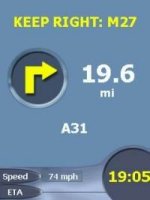
TomTom Navigator
 
TomTom Navigator gives you all the features you need on the Navigator
screen. Not only direction, distance, current and next road, but
also a compass, ETA, speed and satellite status signal.
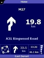
Navman SmartST Pro
Navman although is let down a little by the content on the Navigation
screen, it does still include the essentials like direction, distance,
current and next road, speed, eta but it is missing two major options
which is compass and status signal. However the Navigation screen
does look very snazzy, so it makes up for these loss of features! |
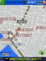
GPS Status Screens
One thing you may not see much of in your
journey, but you do when you commence your journey is the GPS Status screens.
These for most are the essentials, you really do need to make sure you have a
full 3D acquisition before commencing your journey, otherwise the acquisition
time will be severely extended.
|
Navman SmartST Pro |
TomTom Navigator |
|

|

|
|
TomTom Navigator
TomTom are always increasing the use of the status screens, and as in
previous CityMaps and RoutePlanner, the status screen looks similar but
has been built upon over time. It includes all of the information
you need like longitude and latitude, speed, compass direction, GPS
satellite signal strength, satellite lock and an approximation where each
satellite is in the sky. You will also see full UTC time as
retrieved from the satellites atomic clock and a 2D/3D lock designation.
TomTom's latest modification allows you to tap anywhere on the screen to
exit, where as Navman's still requires you to try and press the X button.
Navman SmartST Pro
Navman have tried to keep their status screen as simple as can be, but
giving you the information you need. Again they include longitude
and latitude, speed, compass direction, an overall number of satellite
locks or partial or 2D locks in the sem-circle and also a green large
circle that denotes a full healthy 3D lock. You will also see full
UTC time as retrieved from the satellites atomic clock and a 2D/3D lock
designation. |
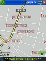
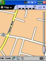
Map Comparisons
A comparison review wouldn't be the same if we
didn't include some screenshots to compare the two products maps side by side.
|
Navman SmartST Pro |
TomTom Navigator |
|
|
|
|
|

|
 |
 |
|
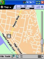
TomTom Navigator
TomTom Navigator maps supplied by TeleAtlas are good, however there are a
lot of inaccuracies or impurities where roads will not be listed
correctly, or are not in the database, or where sea is actually listed as
land. We must say that in the areas we have tested, TomTom maps are
genuinely quite good, however if you feel TomTom Maps may be a problem for
you, see our
TomTom MIA Article
and comments by other Pocket GPS Readers at the bottom of that article.
Navman SmartST Pro
Navman SmartST Pro has used NavTech maps, these maps although they might
not look quite as attractive in colour as the TomTom TeleAtlas maps, you
get more detail of road names using SmartST Pro at the same zoom level
compared to TomTom Navigator. This is achieved by not writing the
road names within the two lines that make up the road, but rather putting
a bullet point on each road, and then hanging a label from this bullet
point. With TomTom Navigator roads, need to be quite large to be
able to put readable text within their lines, and this is where Navman
SmartST Pro and NavTech maps wins. Check out our
Navman Map Errors thread. |
Overall Comparison
TomTom Navigator has been out on the market for
twice as long as Navman's SmartST Pro. Due to this and Pocket GPS users
wanting to have a crack at re-routing, complete single maps rather than
segmented maps, a lot of users have already gone the TomTom Navigator route,
and because of this, there is a much larger following, which in turn means
there's more of a chance to find problems with either the software or the
maps. TomTom have been producing updates to both TomTom Navigator and
it's GPS Support Driver, nearly every 2 to 3 weeks, which has been a welcomed
edition, and we hope this is something that Navman will be doing to fine tune
it's system. We must state though that there have been lots of map
problems found within TomTom, and no matter how many of our contacts at TomTom
we contact, they never return an answer to our question which is a simple one
of "Are you aware of these map problems ? And are you currently working
on these". Most of the Pocket GPS readers would just like to know if
something is being done with the maps, to know that they will not be left high
and dry.
Navman have already said that they will be
certainly looking to create map updates, but as most of these are going to be
of new roads, there may be an upgrade fee for each map update, and Navman are
hoping this will be either once or twice a year for existing users of SmartST
Pro.
As you'll see from the grading percentages
below, there really is not a lot of difference between the two products.
Each product has it's Pro's and Con's.
|
TomTom Navigator
79%
TomTom Navigator maps supplied by TeleAtlas are good, however there are a
lot of inaccuracies or impurities where roads will not be listed
correctly, or are not in the database, or where sea is actually listed as
land. We must say that in the areas we have tested, TomTom maps are
genuinely quite good, however if you feel TomTom Maps may be a problem for
you, see our
TomTom MIA Article
and comments by other Pocket GPS Readers at the bottom of that article.
Navman SmartST Pro
74%
Navman SmartST Pro has used NavTech maps, these maps although they might
not look quite as attractive in colour as the TomTom TeleAtlas maps, you
get more detail of road names using SmartST Pro at the same zoom level
compared to TomTom Navigator. This is achieved by not writing the
road names within the two lines that make up the road, but rather putting
a bullet point on each road, and then hanging a label from this bullet
point. With TomTom Navigator roads, need to be quite large to be
able to put readable text within their lines, and this is where Navman
SmartST Pro and NavTech maps wins. |
|


