| View previous topic :: View next topic |
| Author |
Message |
BigJohnD
Frequent Visitor

Joined: Aug 26, 2007
Posts: 398
Location: Glannau Mersi, Lloegr
|
 Posted: Sat Dec 02, 2017 2:59 pm Post subject: Map display problem Posted: Sat Dec 02, 2017 2:59 pm Post subject: Map display problem |
 |
|
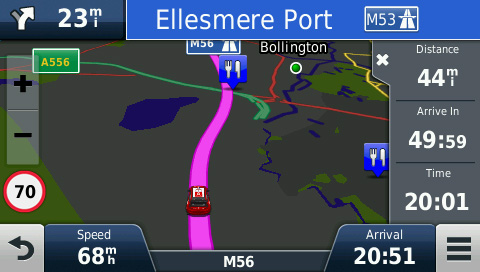
A major junction is missing from the displayed map.
It's a bit hard to describe as it's not there, but it's the junction between the M56 south of Manchester and the A556 to and from the M6. The slip roads etc, were absent when travelling the other way along the M56 later on. So it's unlikely to be a one-off.
Towards Manchester north bound. (Part slip road, green, bottom left)
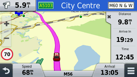
Away from Manchester south bound.
I later re-installed the maps using GE but the fault remains.
Is there a way to completely delete the map file(s) off the SatNav and re-install a fresh downloaded copy?
As an aside, BaseCamp shows everything.
Last edited by BigJohnD on Sun Dec 03, 2017 8:38 pm; edited 1 time in total |
|
| Back to top |
|
 |
M8TJT
The Other Tired Old Man


Joined: Apr 04, 2006
Posts: 10118
Location: Bexhill, South Sussex, UK
|
| Posted: Sat Dec 02, 2017 3:09 pm Post subject: |
|
|
| Strange. My DS61 shows the M56 slip roads, but they are in grey and only show when you are zoomed in. Haven't tried a sim 'dri ve through' though. My maps are 2028.20 |
|
| Back to top |
|
|
Kremmen
Pocket GPS Verifier

Joined: Mar 03, 2006
Posts: 7101
Location: Reading
|
| Posted: Sat Dec 02, 2017 4:13 pm Post subject: |
|
|
With Basecamp, is that using it via the PND device maps or via an older set installed directly into BC ?
I'm no BC expert but when I had it installed it seemed to have various map versions.
Suss will know better.
_________________
DashCam:
Viofo A119 V3
Car Average MPG :
 |
|
| Back to top |
|
|
dales
Frequent Visitor

Joined: May 04, 2008
Posts: 754
Location: Knaresborough, North Yorkshire.
|
| Posted: Sat Dec 02, 2017 4:57 pm Post subject: |
|
|
I'm on 2018.20 maps, and my 2599 unit shows the slip roads and will happily navigate along them in the GPS simulator mode (and shows a nice junction view to prove that it's not missing !)
I think you need to be more zoomed in.
Dales.
_________________
nuvi 2599LMT-D, oregon 700, basecamp, memory-map. |
|
| Back to top |
|
|
sussamb
Pocket GPS Verifier
![]()
Joined: Mar 18, 2011
Posts: 4460
Location: West Sussex
|
| Posted: Sat Dec 02, 2017 6:15 pm Post subject: |
|
|
Have you also set Map detail to More?
You could also confirm the map on your device is okay by plugging in your device and viewing the device's map in BaseCamp.
_________________
Where there's a will ... there's a way. |
|
| Back to top |
|
|
BigJohnD
Frequent Visitor
Joined: Aug 26, 2007
Posts: 398
Location: Glannau Mersi, Lloegr
|
| Posted: Sat Dec 02, 2017 6:41 pm Post subject: |
|
|
Thanks everyone for your input.
| sussamb wrote: | Have you also set Map detail to More?
You could also confirm the map on your device is okay by plugging in your device and viewing the device's map in BaseCamp. |
Maps are NTU 2018.2. Base Camp reads from the device correctly.
Map detail is normal.
Seems to be showing now.
Very confusing.
Last edited by BigJohnD on Sun Dec 03, 2017 8:45 pm; edited 1 time in total |
|
| Back to top |
|
|
M8TJT
The Other Tired Old Man
Joined: Apr 04, 2006
Posts: 10118
Location: Bexhill, South Sussex, UK
|
| Posted: Sun Dec 03, 2017 12:00 am Post subject: |
|
|
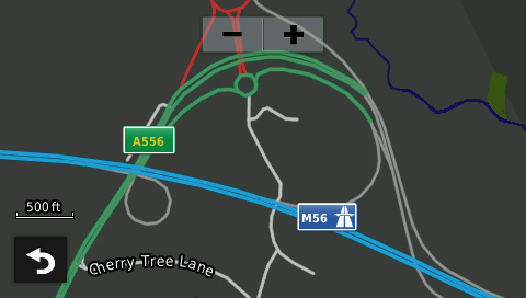
| On mine, it shows the tracks that are in green on your display at any sensible zoom, nut only the slip roads (grey on your display) when zoomed in a bit. It's obviously a mapping error (unless slip roads are always shown grey and I haven't noticed) |
|
| Back to top |
|
|
dales
Frequent Visitor
Joined: May 04, 2008
Posts: 754
Location: Knaresborough, North Yorkshire.
|
| Posted: Sun Dec 03, 2017 12:52 am Post subject: |
|
|
On my 2599, latest maps, map detail set to normal, on a simulation run it drives past the junction and shows all slip roads in grey just fine.
Dales
_________________
nuvi 2599LMT-D, oregon 700, basecamp, memory-map. |
|
| Back to top |
|
|
sussamb
Pocket GPS Verifier
![]()
Joined: Mar 18, 2011
Posts: 4460
Location: West Sussex
|
| Posted: Sun Dec 03, 2017 9:03 am Post subject: |
|
|
The dark display with grey roads is just the night time display though?
_________________
Where there's a will ... there's a way. |
|
| Back to top |
|
|
M8TJT
The Other Tired Old Man
Joined: Apr 04, 2006
Posts: 10118
Location: Bexhill, South Sussex, UK
|
| Posted: Sun Dec 03, 2017 10:06 am Post subject: |
|
|
Yes, but if you look at BigJohn's first daylight pic, you can see the end of the A556 in the bottom left in green bot with no slip roads on to the M56.
It's a map error, categorising the slips lower than the A road, thus they go first as you zoom out. |
|
| Back to top |
|
|
sussamb
Pocket GPS Verifier
![]()
Joined: Mar 18, 2011
Posts: 4460
Location: West Sussex
|
| Posted: Sun Dec 03, 2017 10:34 am Post subject: |
|
|
Sounds right, setting the map detail to More might resolve that though, although if it's just that one junction it's not been coded in the same way as others. I run my devices always on highest detail settings so don't spot those sorts of issues.
_________________
Where there's a will ... there's a way. |
|
| Back to top |
|
|
M8TJT
The Other Tired Old Man
Joined: Apr 04, 2006
Posts: 10118
Location: Bexhill, South Sussex, UK
|
| Posted: Sun Dec 03, 2017 10:56 am Post subject: |
|
|
| I've got mine set to highest but the sliproads go as I zoom out. |
|
| Back to top |
|
|
sussamb
Pocket GPS Verifier
![]()
Joined: Mar 18, 2011
Posts: 4460
Location: West Sussex
|
| Posted: Sun Dec 03, 2017 12:51 pm Post subject: |
|
|
All or just those?
_________________
Where there's a will ... there's a way. |
|
| Back to top |
|
|
M8TJT
The Other Tired Old Man
Joined: Apr 04, 2006
Posts: 10118
Location: Bexhill, South Sussex, UK
|
| Posted: Sun Dec 03, 2017 1:05 pm Post subject: |
|
|
Dunnow. I'll give it a try later.
Later:
A lot. Another example is M23/A23 junction. The joining roads are in black. Same on junction of M25/M23 some slip roads are black. |
|
| Back to top |
|
|
BigJohnD
Frequent Visitor
Joined: Aug 26, 2007
Posts: 398
Location: Glannau Mersi, Lloegr
|
| Posted: Sun Dec 03, 2017 1:15 pm Post subject: |
|
|
The last screen capture was indeed night mode.
I'll check the zoom level but I'd have thought even at the widest zoom the motorway access roads would be displayed.
I'm driving along the M56 past J7 tomorrow so I'll see if all is well.
Thanks for your comments and ideas. |
|
| Back to top |
|
|
|
![]() Posted: Today Post subject: Pocket GPS Advertising Posted: Today Post subject: Pocket GPS Advertising |
|
|
We see you’re using an ad-blocker. We’re fine with that and won’t stop you visiting the site.
Have you considered making a donation towards website running costs?. Or you could disable your ad-blocker for this site. We think you’ll find our adverts are not overbearing!
|
|
| Back to top |
|
|
|


