Hi! We see you’re using an ad-blocker. We’re fine with that and won’t stop you visiting the site.
But as we’re losing ad-revenue from this then why not make a donation towards website running costs?. Or you could disable your ad-blocker for this site. We think you’ll find our adverts are not overbearing!
Posted: Wed Jan 02, 2008 5:45 pm Post subject: Experienced fell walker, novice at GPS
I'm very happy with Ordnance Survey 1:25000 (Explorer) maps and can navigate with this and a compass, so why do I need a GPS?
I guess because I like the idea of being sure where I am and to give a little more confidence in poorer conditions.
I need a hand-held device with OS datum and maps of say 1:25000 resolution. I like the idea of having a graphical presentation, I'd also like to be able to programme in way points from a PC (preferably from an OS map) before I set out, but also to update the route with new points if we change our minds mid-trek. For example to stop and set a way point / reference point for where we are "now".
Battery life should be 6 - 8 hours which may rule out a PDA?
Most of our walking is in the UK, but not necessarily in the National Parks.
Joined: Jan 14, 2005 Posts: 19638 Location: Blackpool , Lancs
Posted: Wed Jan 02, 2008 6:08 pm Post subject:
You can take a look at the established products such as Memory Map which will run on the PC and a PDA, the downside is the PDA it is vulnerable to damage from the elements, to house it you need something like an Otter box to afford it some protection.
As for battery life it is possible to get 8 hours from a PDA running Memory Map, but only if you take precautions to save power, minimal backlight etc.
An alternative is the SatMap active10 which does offer ten hours from a single set of 3 AA batteries (and you can swap them if need be for a replacement set) - mapping is available at 50K and 25K, as yet we are still waiting for the PC planning software to show up, so this is a bit of an unknown at the moment - Mike
Joined: Jan 14, 2005 Posts: 19638 Location: Blackpool , Lancs
Posted: Wed Jan 02, 2008 8:14 pm Post subject:
As it stands I don't think there is anything that can met your full needs, OS maps on a device are rather limited, there are a couple of suppliers for the maps/ application but you are stuck with the PDA to run it effectively, I have tried OS maps on a Smart Phone, but the screen is very small and the application is somewhat lacking in terms of capability.
As I said in the last post take a look at the SatMap device, see This forum section for some additional information, but as yet this cannot do PC based route planning - Mike
Joined: Aug 30, 2007 Posts: 51 Location: Preston, Lancashire, UK
Posted: Wed Jan 02, 2008 10:01 pm Post subject:
Hi,
I have used an extended battery with an HP iPAQ and Memory Map. This will give the battery usage required, but makes the package a lot more bulky. As Mike stated, the unit is extremely vulnerable to the elements and also knocks. I tried a Proporta PDA Crystal Case (which I had to modify for the larger battery) to give a measure of splash protection. Additionally, I found that the screen was not properly daylight readable, even at full brightness. After persevering for a number of walks, I gave up and went for a Garmin Etrex Summit, which I have found to be quite adequate. However, I do miss the graphical route display with your track superimposed!
_________________ Chris B
Joined: Jan 14, 2005 Posts: 19638 Location: Blackpool , Lancs
Posted: Wed Jan 02, 2008 10:14 pm Post subject:
Well I did used to have a custom battery pack built into my Otter box, until I stupidly charged it up using the wrong charger, the net result was battery parts all over the kitchen the following morning! - I have since built another one though I find the active 10 is a better device out on the fells - even more so now its getting cold
Here is some information from a previous post:
mikealder wrote:
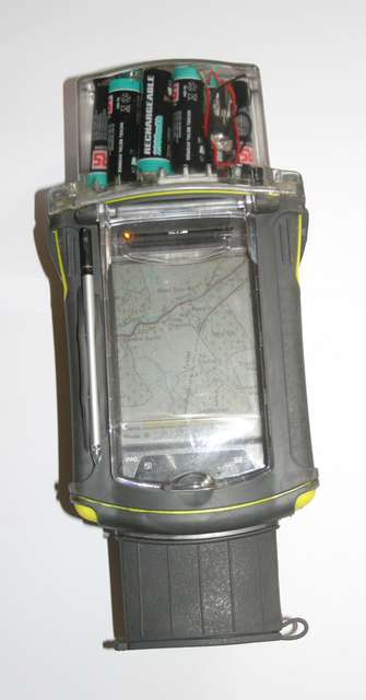
If you want to extend the battery duration for your P550 why not consider one of These They are available in smaller capacities, such as the one I use - lightweight and can recharge the device on the fly - the one I linked to should easily outlast the 76 unit when connected to the P550. You don't need a full time connection, just plug it in when you stop for lunch, tea or overnight.
Note the link is for an external rechargable battery pod not the contraption shown below.
If you want the waterproof aspect for your P550 consider an Otter Box this also offers "alternate" homemade "power pods" to be constructed such as this:
I get around 14 Hours from the ipaq using this method with the display on all the time, you can further extend battery duration by dimming the display or turning the back light off, but 14 Hours should suffice for a long days walk - Mike
Joined: Aug 30, 2007 Posts: 51 Location: Preston, Lancashire, UK
Posted: Wed Jan 02, 2008 10:55 pm Post subject:
Nice photo Mike, but does look a bit of a Heath Robinson to be taking out on the fells!!! I suppose one currently available alternative (at some cost) is the Garmin etrex Vista Cx or similar. I've only seen one in a shop, unpowered and my opinion was that the screen seemed extremely small and looked like it would only cover a small map area at a readable zoom setting.
Chris B _________________ Chris B
Joined: Aug 21, 2005 Posts: 617 Location: Gloucester UK
Posted: Thu Jan 03, 2008 2:21 am Post subject:
I was going to say, Is something like THIS
What you are looking for. Its a bit like my e-trek, but it has maps. _________________ Audi A3 Sline sat nav
Joined: Dec 28, 2005 Posts: 2003 Location: Antrobus, Cheshire
Posted: Thu Jan 03, 2008 11:58 am Post subject:
If you are used to using 1:25000 OSGB maps then nothing else will do for walking. Nothing else has the level of detail that is required for navigation. Things like wall boundaries are often the only detail visible to you. (But you aren't meant to use electricity pylons for navigation - their positions are not correctly surveyed in many instances.)
So it's down to 'Heath Robinson' solutions with boxes and batteries. I've tried Proporta power pack and a Pelibox (waterproof box with foam padding) but it gets too bulky. As I have mentioned elsewhere I prefer to use Anquet/Memory Map to plan a route and use a non-mapping GPS to hold the route(s) and waypoints (including some contingency waypoints). Then you can print off a specific map(s) with routes and waypoints marked on them. These can be used instead of the regular OS maps on the walk. With the paper map it is possible to manually enter 'emergency' waypoints for escape (or resort to good old compass bearings).
Devices like the SATMAP, hopefully, will develop into reliable solutions for rugged UK mapping - it's just the cost of "re-buying" the maps that is annoying at this point in time. _________________ Phil
Joined: Aug 30, 2007 Posts: 51 Location: Preston, Lancashire, UK
Posted: Thu Jan 03, 2008 5:24 pm Post subject:
philpugh wrote:
Quote:
If you are used to using 1:25000 OSGB maps then nothing else will do for walking. Nothing else has the level of detail that is required for navigation. Things like wall boundaries are often the only detail visible to you. (But you aren't meant to use electricity pylons for navigation - their positions are not correctly surveyed in many instances.)
I agree totally with philpugh as regards 1:25000 mapping for fell / off road walking. In my view, the 1:50000 maps are quite inadequate in some areas for detailed navigation and can be vey confusing.
As phil said, the section of map you require can be printed form Memory Map or similar, then all the waypoints can be marked on. I have found that waterproof inkjet paper is excellent for this job. It is available on the Memory Map website. It isn't cheap, but can be printed on both sides. It can be used in a mapcase and will survive the elements, wheras a map on normal paper ends up as a pscychedelic mess. Been there, done that.
Hopefully, one day, a ruggedised, weatherproof PDA screen sized GPS with a daylight readable screen and a 10 hour battery duration will be produced.
Joined: Dec 28, 2005 Posts: 2003 Location: Antrobus, Cheshire
Posted: Thu Jan 03, 2008 5:48 pm Post subject:
bradders2 wrote:
I have found that waterproof inkjet paper is excellent for this job. It is available on the Memory Map website. It isn't cheap, but can be printed on both sides. It can be used in a mapcase and will survive the elements, wheras a map on normal paper ends up as a pscychedelic mess. Been there, done that.
I find that standard paper used in conjuntion with a good map case survives quite well. I use a Canon ip2000 with Canon original inks - nothing fancy. No probs on a walk on 29/12/07 at the Cat and Fiddle with 40mph winds and rain - map was certainly useable at end of 10 mile/3.5 hour walk. It may have been different for a whole day walk and I have used a laminator and then map case as belt-and-braces. I throw them away afterwards anyway as I have the original data to re-create if needed. _________________ Phil
Remembering I'm a novice at GPS! If I get say, a Garmin® etrex GPS Vista® Cx for example, can I plot the route using Memory Map on a PC and download the waypoints (Hope I'm getting this terminology right) onto the Garmin? What sort of image do I then get on the Garmin?
I would like to exploit the accuracy of the GPS device without the weak link being my +/- 100m precision in quoting a 6 figure OS reference, so loading waypoints digitally would be helpful.
I'm more than happy to take a paper map in any form. I very likely already have the 1:25000 sheet and usually laminate anything which won't be in the map case.
Joined: Aug 30, 2007 Posts: 51 Location: Preston, Lancashire, UK
Posted: Thu Jan 03, 2008 10:11 pm Post subject:
iamian16 wrote:
Quote:
Remembering I'm a novice at GPS! If I get say, a Garmin® etrex GPS Vista® Cx for example, can I plot the route using Memory Map on a PC and download the waypoints (Hope I'm getting this terminology right) onto the Garmin? What sort of image do I then get on the Garmin?
I would like to exploit the accuracy of the GPS device without the weak link being my +/- 100m precision in quoting a 6 figure OS reference, so loading waypoints digitally would be helpful.
You can download a route to a Garmin etrex using Memory Map. You plot your route with waypoints on Memory Map which uses 10 figure OS Grid Refs, so they are pretty accurate. On completion of your walk, you can upload your actual track back into Memory Map superimposed on your original route. I have found that using an etrex Summit (with no graphical map display) that my waypoints are usually within 8 metres of the intended position, which is quite acceptable (to me).
My etrex Summit and the basic etrex show a bearing and a distance to go with respect to the next waypoint. On arrival, it switches to the next waypoint. As has been said earlier, if the waypoints have been marked on a map, then navigation can progress along the route.
The Garmin etrex Venture, Legend??? and Vista have a map display with the route superimposed (I think). I have not seen one of these in action, but the screen area is quite small, so I would imagine they would be quite difficult to read unless you are displaying only a small map area.
Joined: Dec 28, 2005 Posts: 2003 Location: Antrobus, Cheshire
Posted: Fri Jan 04, 2008 10:42 am Post subject:
[quote="bradders2]
The Garmin etrex Venture, Legend??? and Vista have a map display with the route superimposed (I think). I have not seen one of these in action, but the screen area is quite small, so I would imagine they would be quite difficult to read unless you are displaying only a small map area.
[/quote]
This is the usual problem with these devices - you don't get enough of a view on the small screen. The device you mention will only come with a base map - marking centres of large towns and some major roads. This is of zero use to an experienced walker. I'm with ChrisB here - use the basic function of the GPS device alongside familiar maps. _________________ Phil
You can take a look at the established products such as
An alternative is the SatMap active10 which does offer ten hours from a single set of 3 AA batteries - mapping is available at 50K and 25K, as yet we are still waiting for the PC planning software to show up, so this is a bit of an unknown at the moment - Mike
I called in the local outdoors shop this afternoon and they were keen to sell the Satmap Active 10. It looks good, I like the idea of it taking "normal" batteries but it seems devilishly expensive at £289 and the maps are £99 each, that's nearly £400 to get started!
What I don't understand from Mike's message is that about PC planning. Are the £99 SD card maps for the SatMap readable through a PC card reader?
Posted: Today Post subject: Pocket GPS Advertising
We see you’re using an ad-blocker. We’re fine with that and won’t stop you visiting the site.
Have you considered making a donation towards website running costs?. Or you could disable your ad-blocker for this site. We think you’ll find our adverts are not overbearing!
You cannot post new topics in this forum You cannot reply to topics in this forum You cannot edit your posts in this forum You cannot delete your posts in this forum You cannot vote in polls in this forum
Or you could disable your ad-blocker for this site. We think you’ll find our adverts are not overbearing!
Hi! We see you’re using an ad-blocker. We’re fine with that and won’t stop you visiting the site.
But as we’re losing ad-revenue from this then why not make a donation towards website running costs?. Or you could disable your ad-blocker for this site. We think you’ll find our adverts are not overbearing!