| View previous topic :: View next topic |
| Author |
Message |
Andy_P
Pocket GPS Moderator


Joined: Jun 04, 2005
Posts: 19991
Location: West and Southwest London
|
 Posted: Fri Jan 13, 2012 4:11 pm Post subject: Posted: Fri Jan 13, 2012 4:11 pm Post subject: |
 |
|
| Calomax wrote: | | AirJing2010 wrote: |
Does this still happen when you take up the TomTom regular update subscription? |
Not if you copy in your Mapsettings file from your previous backup. |
It shouldn't happen on recent models anyway. That bug has been pretty much squished on the NAV3 TomToms (software v10 or 11) but there are a lot of v8 and 9 models still out there which still usually (but not always) need the workround Calomax mentions.
_________________
"Settling in nicely" ;-) |
|
| Back to top |
|
 |
oldfogy
Frequent Visitor

Joined: May 08, 2006
Posts: 252
Location: West Midlands. UK
|
 Posted: Fri Jan 13, 2012 6:15 pm Post subject: Posted: Fri Jan 13, 2012 6:15 pm Post subject: |
 |
|
Obviously I would not like it to happen too often, but maybe something similar to the truck map where you can pre-select your type of vehicle would be one step in the right direction.
Except maybe if the information was required to be input possibly every so many journeys or just asked automatically on startup again after so many start-ups.
At least that way, if a mistake has been input a reminder is going to give you the chance of correcting it every so often.
Obviously to some people it will be like water of a ducks back, but will stop some of the silly problems from happening.
_________________
(If it ain't broke, I can soon fix it) |
|
| Back to top |
|
 |
oldfogy
Frequent Visitor

Joined: May 08, 2006
Posts: 252
Location: West Midlands. UK
|
 Posted: Fri Jan 13, 2012 6:32 pm Post subject: Posted: Fri Jan 13, 2012 6:32 pm Post subject: |
 |
|
| exportman wrote: | I wonder how the software works the route out.
I have a tomtom and Navigon on a android phone up until the latest tomtom update the tomtom always chose a to me strange way to route me for the last couple of miles home ( I never followed it but ..) where are the Navigon used the route I would naturally go. Now the tomtom shows the same route nothing has changed on these roads for 30 years.
Also tomtom still shows side streets that have been a large supermarket carpark since 1999 |
Would that have anything to do with the 'Self learning software' that I have heard about, whereas the Tomtom recognises the route you ignored and then offers the route that you took instead the next time the same situation crops up?
_________________
(If it ain't broke, I can soon fix it) |
|
| Back to top |
|
 |
aj2052
Frequent Visitor

Joined: Jul 03, 2005
Posts: 1431
Location: Leics,UK
|
 Posted: Sat Jan 14, 2012 2:06 am Post subject: Posted: Sat Jan 14, 2012 2:06 am Post subject: |
 |
|
Im with Dennisn on this one,
Check this one out using Hybrid map on this site:Centre Latitude: 52.77374125018259 Longitude: -1.2070342898368835 (shakespeare street,Loughborough) shows shakespeare street going straight thru centre of Marks and Spencers store to tee junction and then left thru more buildings, secondly junction of Biggin street/Swan street pedistrian kerbed area with no vehicle access, but not with current teleatlas on Sygic Android or tomtom.
This massive rebuild was done i believe about 2003 and i have personally reported at least 6 times plus a incorrect named road near me named in 1999 still not corrected, needless to say why bother reporting.
incidently the mapping and sat maps onsite do not seem as clear as they used to be and prevously shakespear street tee junction used to go thru M&S Store seems a little offset now.
_________________
Moto G5s Plus, Sygic 17.4.8 |
|
| Back to top |
|
 |
oldfogy
Frequent Visitor

Joined: May 08, 2006
Posts: 252
Location: West Midlands. UK
|
 Posted: Sat Jan 14, 2012 2:23 am Post subject: Posted: Sat Jan 14, 2012 2:23 am Post subject: |
 |
|
I gave up reporting inaccuracies to TomTom ever since they can't be bothered to put my friends half of the road on the map.
According to TomTom the house numbers finish at number 42, whereas they actually finish at approximately 74.
Four years and still waiting...
*****************************
Yesterday my TomTom wanted to take me across a junction down a no entry junction that does not even have a road that you could use to drive down as there is only a road for traffic coming the other way.
_________________
(If it ain't broke, I can soon fix it) |
|
| Back to top |
|
 |
Andy_P
Pocket GPS Moderator


Joined: Jun 04, 2005
Posts: 19991
Location: West and Southwest London
|
 Posted: Sat Jan 14, 2012 2:24 am Post subject: Posted: Sat Jan 14, 2012 2:24 am Post subject: |
 |
|
| oldfogy wrote: | | Would that have anything to do with the 'Self learning software' that I have heard about, whereas the Tomtom recognises the route you ignored and then offers the route that you took instead the next time the same situation crops up? |
Any idea where you read about that?
It's a new one on me!
_________________
"Settling in nicely" ;-) |
|
| Back to top |
|
 |
oldfogy
Frequent Visitor

Joined: May 08, 2006
Posts: 252
Location: West Midlands. UK
|
 Posted: Sat Jan 14, 2012 2:45 am Post subject: Posted: Sat Jan 14, 2012 2:45 am Post subject: |
 |
|
| Andy_P wrote: | | oldfogy wrote: | | Would that have anything to do with the 'Self learning software' that I have heard about, whereas the Tomtom recognises the route you ignored and then offers the route that you took instead the next time the same situation crops up? |
Any idea where you read about that?
It's a new one on me! |
I think it was on the Navitotal forum, which was in reply to a similar comment as the comment I replied to above.
I will see if I can find it again over the week-end and get back to you if I do, but it did not say much more than what I have said above, which I know is very little.
_________________
(If it ain't broke, I can soon fix it) |
|
| Back to top |
|
 |
DennisN
Tired Old Man


Joined: Feb 27, 2006
Posts: 14901
Location: Keynsham
|
 Posted: Sat Jan 14, 2012 9:44 am Post subject: Posted: Sat Jan 14, 2012 9:44 am Post subject: |
 |
|
I'm not embittered, I just don't have time to stop and make notes about map errors.
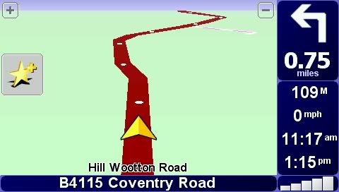
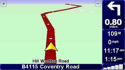
Evidence of reduced map detail as follows - two views of different map versions, second showing less bend details. Maybe I'll see if I can show some differences between old maps and later ones, but it takes some doing.


_________________
Dennis
If it tastes good - it's fattening.
Two of them are obesiting!! |
|
| Back to top |
|
 |
DennisN
Tired Old Man


Joined: Feb 27, 2006
Posts: 14901
Location: Keynsham
|
 Posted: Sat Jan 14, 2012 4:10 pm Post subject: Posted: Sat Jan 14, 2012 4:10 pm Post subject: |
 |
|
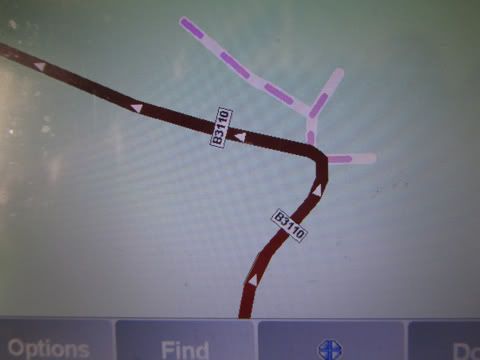
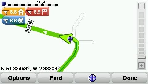
So here we are with evidence of reduced details in TomTom maps. I rather imagine this is due to the introduction of other "detail" for the likes of IQ Routes and MapShare. As both of those features have limited value in my opinion, I'd much prefer road details instead. I wonder how other maps fare on say Garmins?
First picture is map v675...

This picture is the latest map, v880...

This is on my route home from anywhere south east of here. Note that on the second picture, I am instructed to turn left on that bend, whereas on the first picture I am not, because the side roads are marked as non-navigable - the first right is a gated entrance to a cattery, the second is an unsurfaced farm entrance track.
I get this sort of thing regularly for many laybyes - I didn't get it with earlier maps which showed them as "off road". I strongly suspect that many of the routes now taking innocent naive drivers through fords or unsurfaced roads are due to this degradation of map detail.
_________________
Dennis
If it tastes good - it's fattening.
Two of them are obesiting!! |
|
| Back to top |
|
 |
Fellwalker
Lifetime Member

Joined: Apr 18, 2006
Posts: 207
Location: Up North
|
 Posted: Sat Jan 14, 2012 9:10 pm Post subject: Posted: Sat Jan 14, 2012 9:10 pm Post subject: |
 |
|
I see what you mean, Dennis. On my Sygic Mobile maps it looks like your first screen shot. On google satellite view it shows how even that is an approximation of the reality.
I know that i far preferred the maps on my first GPS, which was Copilot, to those on the later TomTom 6 and the Sygic. They seem not quite to reflect the true course of the roads, whereas I would often have the Copilot on to help anticipate the road ahead. However, the Copilot routing was poor, which in the end meant it was consigned to the bin.
_________________
Samsung Galaxy Note 9, Nexus 5, Galaxy tab S3. Also use OSMAnd+, Sygic Mobile Maps, and OS maps app. Also "Great Britain Topo Maps" and "Old Maps". Don't use speed camera database as sticking to the limit is safer. |
|
| Back to top |
|
 |
spook51
Lifetime Member

Joined: Mar 26, 2004
Posts: 548
Location: East Midlands
|
 Posted: Mon Jan 16, 2012 5:04 pm Post subject: Posted: Mon Jan 16, 2012 5:04 pm Post subject: |
 |
|
It's nonsense to suggest that detailed rendering of every twist and turn in a road is essential when navigating from A to B. All that is necessary are start and finish points, turns left or right and distances and sometimes all those aren't necessary either depending on the tye of instruction provided - try navigating using map references, tulip diagrams or herringbones on a night rally in a pre-war car, it only requires a little bit of knowledge and savvy and you can find your way just as well as using a satnav - some would say more easily. Or, if pictorial information is needed, simply follow a map like in the good old days!
As I've stated before, it doesn't matter how good, how cheap or how often maps are updated until and unless drivers use their commonsense (which may be imposed by legislation) vehicles will continue to be driven on inappropriate roads. |
|
| Back to top |
|
 |
M8TJT
The Other Tired Old Man


Joined: Apr 04, 2006
Posts: 10118
Location: Bexhill, South Sussex, UK
|
 Posted: Mon Jan 16, 2012 5:46 pm Post subject: Posted: Mon Jan 16, 2012 5:46 pm Post subject: |
 |
|
| spook51 wrote: | | It's nonsense to suggest that detailed rendering of every twist and turn in a road is essential when navigating from A to B. |
I think that dennis was pointing out that TT maps are getting LESS detailed rather than more as people seem to think is a 'good thing'. Having said that, I'm with you on pretty much all you have said, especially your last paragraph. |
|
| Back to top |
|
 |
Andy_P
Pocket GPS Moderator


Joined: Jun 04, 2005
Posts: 19991
Location: West and Southwest London
|
 Posted: Mon Jan 16, 2012 6:03 pm Post subject: Posted: Mon Jan 16, 2012 6:03 pm Post subject: |
 |
|
| spook51 wrote: | | It's nonsense to suggest that detailed rendering of every twist and turn in a road is essential when navigating from A to B. All that is necessary are start and finish points, turns left or right and distances..... |
You're an experienced enough user to know that the TomTom mapping ISN'T dynamically altered to show less detail if those details aren't needed for your current route.
What you see, is what you get, so Dennis' example is simply showing that various details that used to be on the map aren't there any more.
_________________
"Settling in nicely" ;-) |
|
| Back to top |
|
 |
DennisN
Tired Old Man


Joined: Feb 27, 2006
Posts: 14901
Location: Keynsham
|
 Posted: Tue Jan 17, 2012 1:13 am Post subject: Posted: Tue Jan 17, 2012 1:13 am Post subject: |
 |
|
| spook51 wrote: | | It's nonsense to suggest that detailed rendering of every twist and turn in a road is essential when navigating from A to B. All that is necessary are start and finish points, turns left or right and distances..... |
I was NOT suggesting detailed rendering of every twist and turn - my first pictures merely demonstrated that TomTom are reducing the amount of detail on their maps and they were the only examples readily available at the time of my post.
The second set of pictures show how road classification has been removed from some roads, leaving them showing as "normal" roads, hence navigable. I really can't be bothered trying to find more examples to make the point, but there will be a lot of them. The point is simply that if TomTom cease to map a road as non-navigable, obviously the device will apply its algorythms to decide whether or not to navigate along it. With nothing else to influence the result, the driver may well be directed down a narrow, twisty "normal" road, to get stuck. I'm not concerning myself with the fools who don't look out the windscreen and exercise judgement - some of them will have followed their satnavs to the correct destination without hazards in the past and will be likely to be inclined to believe the satnav is offering them a navigable route. Marry a faulty map with an idiot and you get lorries in narrow lanes and cars in streams. By faulty map, I mean a map which now shows a navigable road where previously it showed it as non-navigable. Hence I get instructed to take the better route by turning right (or keeping right) at many laybyes - if the layby just happened to be cutting off a corner, might the satnav direct me through it? Maybe this is the explanation for some routes being on and off slip roads at some motorway junctions?
As a side effect, how much extra processing power is being used (delaying) calculating all these unnecessary extra instructions?
My case regarding a government summit is that TomTom are reducing the detail of roads to the extent that their devices now show navigable roads which are either not navigable or only navigable under stressed conditions. They are then using those roads to plan routes which get drivers into difficulties - the government holding a summit on the subject will be another sound bites opportunity which would be unnecessary if only satnav maps marked cart tracks as cart tracks, not roads.
_________________
Dennis
If it tastes good - it's fattening.
Two of them are obesiting!! |
|
| Back to top |
|
 |
M8TJT
The Other Tired Old Man


Joined: Apr 04, 2006
Posts: 10118
Location: Bexhill, South Sussex, UK
|
 Posted: Tue Jan 17, 2012 10:07 am Post subject: Posted: Tue Jan 17, 2012 10:07 am Post subject: |
 |
|
| DennisN wrote: | | the government holding a summit on the subject will be another sound bites opportunity which would be unnecessary if only satnav maps marked cart tracks as cart tracks, not roads. |
And a terrible waste of taxpayers' money to prevent just a few mishaps a year due to the idiots who will still continue to be idiots.  |
|
| Back to top |
|
 |
|
![]() Posted: Today Post subject: Pocket GPS Advertising Posted: Today Post subject: Pocket GPS Advertising |
|
|
We see you’re using an ad-blocker. We’re fine with that and won’t stop you visiting the site.
Have you considered making a donation towards website running costs?. Or you could disable your ad-blocker for this site. We think you’ll find our adverts are not overbearing!
|
|
| Back to top |
|
 |
|