Hi! We see you’re using an ad-blocker. We’re fine with that and won’t stop you visiting the site.
But as we’re losing ad-revenue from this then why not make a donation towards website running costs?. Or you could disable your ad-blocker for this site. We think you’ll find our adverts are not overbearing!
You have all forgotten one very important thing. The reason for doing this is so they can sell more at higher value. Unfortunatly most people buy the stuff with "bling" over the stuff that consistently works well . They don't find out it doesn't work well till they have used it for a while. Therefore the manufacturers will product an adaquate product then add 'bling' rather than a great product that works well.
Here how product lifecycles go - first up is 'something that sort of works most of the time' (Early PPC's and the likes of Navman iCN630 V1 software). Then it moves to 'Works well enough, most of the time, for most people' (Nav products circa Q1, 2006). Then they start adding 'bling' - Cameras, Phone connectivity, configurable voices etc.
If you ar lucky, they add reliably but only to the top end products, and in a few products, they take out the 'bling' that made them harder to use and less reliable.
Joined: Jul 21, 2004 Posts: 2718 Location: Chelmsford, UK
Posted: Fri May 11, 2007 9:25 am Post subject:
Yep, eventually this will of course comfortably outsell 2D... not for any technical reasons, but purely on the basis that people will see it, love it and buy it.
Bling for sure, but the marketeers know what they are doing. _________________ Robert Brady
Joined: Aug 31, 2005 Posts: 15152 Location: Bradford, West Yorkshire
Posted: Fri May 11, 2007 2:48 pm Post subject:
mostdom wrote:
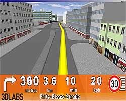
Just looking at the first picture and the junction in the distance. If you take the buildings out and just leave the detailed road layouts it could be quite good. Who knows how many times my gps tells me to turn at complicated junctions when in reality that turn could be one of many, wrong lane, filter lane, etc...
don't forget that this is not an actual device screen shot - simply a demo of what can be achieved. in the same way we can select map detail on 2d maps on current devices, i'm sure on the next generation devices that use these 3d maps there will be an option to turn buildings off.
teleatlas simply provide the data, it's tomtom, garmin, navman et al who decide how they implement it
No. It's much MUCH faster to interpret a basic 2D map than to figure out a 3D one. The less data, the better (I studied HCI and degree-level user interface design). Why do you think many sat nav devices switch to an extremely basic "Safety View" over a certain speed?
What a complete load of rubbish! Don't you realise that there are a lot of people out there who simply can't interpret map data on the spare of the moment (many can't read maps full-stop!). Having a view that is remotely like what you should be seeing out of the windscreen is a huge advantage to most people.
I wouldn't boast about the HCI course too much, I also studied it and I also work in the IT industry where you soon learn how little of it applies in the real world.
Don't you realise that there are a lot of people out there who simply can't interpret map data on the spare of the moment (many can't read maps full-stop!).
I must be the only one here that likes it, I would like the option to have 3D buildings, as long as they look like the real buildings so you can relate to them
Joined: Jan 14, 2005 Posts: 19638 Location: Blackpool , Lancs
Posted: Sun May 13, 2007 9:35 am Post subject:
So, I guess I will not be in the majority when this comes out
Too heavy on storage space
Too heavy on processor power
Will require faster processor
Will require larger battery capacity
I guess they could reduce the cost of the maps though by "selling" map space so the buildings are tagged with names and phone numbers as a form of advertising, some will say this idea of advertising is being silly - It is on the par with the whole idea IMHO - not interested one bit to be honest - Mike
Joined: Jul 21, 2004 Posts: 2718 Location: Chelmsford, UK
Posted: Sun May 13, 2007 10:10 am Post subject:
mikealder wrote:
I guess they could reduce the cost of the maps though by "selling" map space so the buildings are tagged with names and phone numbers as a form of advertising, some will say this idea of advertising is being silly
I ask the guys at Google about their interest in SatNav every time we meet and, although they don't talk specifics, they wag their tails with excitement... and they have been for the last 3 years.
A professor from a well-known UK University (sorry, can't say) came to visit me 2 years ago and whilst demonstrating stunning looking 3D routes, spoke of 'branding' the shops and commercial buildings.
My money is firmly on Google (as well as others of course) making money out of this space.
The 3D images that you'll see in your car of the future will be Google Earth based and the advertising directly linked to millions of POIs. Still a long way to go, but it'll happen. _________________ Robert Brady
Joined: Jan 04, 2007 Posts: 2789 Location: Hampshire, UK
Posted: Sun May 13, 2007 10:49 am Post subject:
The trouble is that if you're looking for a large building or shop and it changes ownership (eg Allders going out of business), you could be more likely to get lost than if you're looking for a road name.
...the longer the comapny name, the more difficult it will be to display it on a sceen - ASDA may fit clearly, whereas Pocket GPS World would have to be so much smaller that it wouldn't be worth including.
Also, the more information you put on a map, the more distracting it will be and the more likely a driver will be to blame sat nav when he/she has an accident. _________________ Andy
PocketGPSWorld.com supports Help for Heroes - Read here
Joined: Jan 04, 2007 Posts: 2789 Location: Hampshire, UK
Posted: Sun May 13, 2007 2:05 pm Post subject:
...on the other hand, I guess it would be no different to advertising on an F1 car which passes so quickly it's all just a blur (except perhaps for the main sponsors on the tail fin or those which determine the colour of the car).
With these new maps, it would be cheaper and easier to drive past a shop or pizza delivery place to see what phone number is displayed than to use one of the many directory enquiry services.
Seriously, though perhaps PGPSW could add to the 'Poll' forum:
1) How many PGPSW members use 2D maps vs 3D maps
2) How many PGPSW members would find the new 3D maps of benefit over the traditional 3D maps
As far as I can see, it's only PGPSW staff who are able to setup new polls _________________ Andy
PocketGPSWorld.com supports Help for Heroes - Read here
Joined: 03/05/2003 14:45:49 Posts: 3999 Location: leyland lancs ENGLAND
Posted: Sun May 13, 2007 4:43 pm Post subject:
i think it would be better to wait untill application start to use the new 3d data and then do a poll as yet know one knows who if anyone will employ it. also it depends on how the data is diplayed one application may display it better than another _________________ currently using aponia truck navigation on windows phone. Good bye IOS don't let the door hit you on the way out .
Oh the joys of being a courier.
device Lumia 950 xl
Reading through the posts so far - I have to disagree with most of them
The only serious complaints I've seen anyone raise wrt the new 3D maps are:
Complaint 1) The time writing the software to implement this would have been better spent correcting the maps.
Isn't this a stupid complaint?
AIUI, the people creating the map data are not the same people as those writing the software. Maps are supplied by one company (teleatlas), software another (igo in this case).
Additionally, the GPS systems which are employed to gather map data do so just as easily as they get GPS coordinates - look at your own GPS unit and you'll probably see it displaying how high you are
Further, in order to get the buildings data; presumably many of the roads would have to have been revisited (I seriously doubt that this information would have been collected in when generating any previous maps). This would have the effect of updating the maps anyway unless satellite photography was being used...
Complaint 2) The addition of buildings on the user's display makes the GPS display more dangerous as it'll take up more of the user's concentration.
This is probably a more valid complaint, though it's inevitable that there's going to be an option to switch buildings off - in much the same way you can switch current "3D" views off to see a 2D view today
Of course, users will probably leave them switched on - but it could be argued that the display of buildings makes the GPS display safer; if the user's on the right road, a quick glance at the display will suffice to compare it with what can be seen on the road - rather than having to interpret a conventional map display
I'd be inclined to reserve judgement on that one; IMHO it's the sort of thing where you need to try it out to see if it has any effect. It's certainly possible that it may well make things more dangerous if the user is off course and what they see out the window doesn't match the display
I'd say that the addition of buildings provides a valuable tool to show the user landmarks. At present, this is typically limited only to streetnames, etc - which can make it difficult to identify which direction you're looking in/where to go at times.
FWIW, looking at the iGO software - it's not just buildings that are going to be rendered, but contours as well - fantastic!
Maybe only now we'll start calling so-called "3D" GPS views by their rightful name - "2.5D", which is what they really are - a 2D map shown on a perspective view! _________________ Sarah Dean
FreeOTFE site: http://www.FreeOTFE.org/
Personal site: http://www.SDean12.org/
For information on SecureTrayUtil and On-The-Fly Encryption (OTFE) systems (including transparent encryption for PDAs), see the URLs above
Joined: Jan 04, 2007 Posts: 2789 Location: Hampshire, UK
Posted: Sun May 13, 2007 7:33 pm Post subject:
SarahDean wrote:
Reading through the posts so far - I have to disagree with most of them
This is your first post - you haven't exactly made it clear what your experience with GPS is, which GPS unit you are using.
If, as many of us complain, the maps are out of date - it's even less likely that buildings will be updated, hence your argument
Quote:
if the user's on the right road, a quick glance at the display will suffice to compare it with what can be seen on the road
falls down.
If people can't interpret map data then they probably can't interpret the highway code either and that's why there are so many bad drivers about!!
Some of us have more than 10 years' experience and have a fairly good idea of what we're talking about.
For all we know, you might be the girl in Wales who tried driving down the railway line and blamed her sat nav. _________________ Andy
PocketGPSWorld.com supports Help for Heroes - Read here
Posted: Today Post subject: Pocket GPS Advertising
We see you’re using an ad-blocker. We’re fine with that and won’t stop you visiting the site.
Have you considered making a donation towards website running costs?. Or you could disable your ad-blocker for this site. We think you’ll find our adverts are not overbearing!
You cannot post new topics in this forum You cannot reply to topics in this forum You cannot edit your posts in this forum You cannot delete your posts in this forum You cannot vote in polls in this forum
Or you could disable your ad-blocker for this site. We think you’ll find our adverts are not overbearing!
Hi! We see you’re using an ad-blocker. We’re fine with that and won’t stop you visiting the site.
But as we’re losing ad-revenue from this then why not make a donation towards website running costs?. Or you could disable your ad-blocker for this site. We think you’ll find our adverts are not overbearing!