SatNav,GPS,Navigation
Free Email Updates
Get speed camera database update alerts, news and reviews. Example

Enter Your Email
(for our eyes only & one click unsubscribe)
No Spam Guaranteed!
Navigate Our Site

MEMBERS AREA
Subscribe Now
Speed Camera Download
Submit Cameras
Free Competition
Member Discounts
Your Account
Member Forums

PUBLIC GPS FORUMS
Register to Post
Log in to Post
Private Messages
Your Account
Public GPS Forums
FORUMS BY BRAND
POINTS OF INTEREST
Free POIs
Submit POIs

REVIEWS & ARTICLES
Full Listing
[+] Anquet
[+] Apple
[+] Article
Viewranger in for review : Nov09

TomTom add support for iPod Touch and iPhone 2G : Nov09

Popular Free iPhone Dating App Adds GPSBased Chat Feature : Nov09

NDrive Dominate GPS Software for Phones Comparison : Nov09

M11 Speed Camera Increases Accidents and Raises 500kYear : Nov09

Nav N Go Powers GPS RearView Mirror : Nov09

iPhone Touch GPS Cradle launched by Dual Electronics : Nov09

TurnbyTurn Nav For The iPod Touch Approved by Apple : Nov09

NDrive London with Aerial Photo View Released iPhone : Nov09

Reviewed Roadhawk RH1 Black Box InCar GPS Camera : Nov09

Smartphone GPS Usage Surges Ahead in China : Nov09

Carcomm TomTom x40x50 Cradle Available : Nov09

Residents take action against satnav map errors : Nov09

RouteBuddy Atlas 150K OS Great Britain Map Available : Oct09

Google unveils free turnbyturn navigation for Android : Oct09

125 Casualties x 5 years 17 Speed Cameras : Oct09

TurnbyTurn Navigation Comes to The iPod Touch : Oct09

New French Speed Cameras Predicted For UK Roads : Oct09

Columbus nGPS geotagging dongle for Nikon cameras review : Oct09

GMap UK Ireland for iPhone Released : Oct09

DIY Speed Camera Slows Traffic : Oct09

Can Speed Save Lives : Oct09

UK Speed Cameras Safety or Votes : Oct09

NDrive iPhone UK and Ireland Now Available : Oct09

Calling All Speed Camera Warning Virgins : Oct09

Navigon win the Stuff Award 2009 for SatNav : Oct09

Build your own GPS Satellite Build Win A Subscription : Oct09

Wales Plans Mobile Average Speed Cameras : Oct09

Gaia GPS iPhone GPS App with Topo Maps : Oct09

NDrive Coming to iPhone and Android Phones : Oct09

There are new waze in town : Sep09

Speed Cameras Cash Machines or Safety Systems : Sep09

RoadTour Announce Britains Finest : Sep09

LBS Start Up Tops Up His Half Million Dollar Prize : Sep09

Directional Warnings for All Well Nearly : Sep09

Does This Signal the End of Mobile GPS : Sep09

Driver slapped with 900 fine for following TomTom : Sep09

Communicating with Subscribers Newsletter Subscriptions : Sep09

Smartphones Integrated into Vehicle Infotainment Systems : Sep09

Geocoded PostCode Database Leaked Online : Sep09

GyPSii launches on Android : Sep09

Traffic4England RealTime Traffic Alerts for Android : Sep09

TomTom Announce New Location Referencing Technology : Sep09

90 Percent of Wakefields Speed Cameras Are Dummies : Sep09

OS Map Ordnance Survey Maps on Android : Sep09

Garmin Announces Edge 500 Cycling GPS Device : Sep09

Augmented Reality Navigation Wikitude Drive : Sep09

Number Plates Unnecessary For Speed Camera Prosecution : Aug09

Only 27 of UK Drivers Believe Speed Cameras Improve Safety : Aug09

We need your help FREE Two Year subscriptions on Offer : Aug09

Bournemouth Speed Cameras Torched : Aug09

Free Priority Delivery for TomTom Refurbs : Aug09

Speed Cameras A Personal View : Aug09

End of an era for GPS as GPS 2RM8 is launched : Aug09

OpenStreetMap Data Now Available on Submission Maps : Aug09

Spanish Tunnel Vision : Aug09

Warning Reindeer Ahead Speed Limit 40 Kilometers per hour : Aug09

NAVTEQ Study Confirms SatNav BoyToy Status : Aug09

Sygic Mobile Maps coming to Android : Aug09

Bournemouth Consider Copying Swindon to Switch off Speed Cams : Aug09

O2 Joins with Telmap to Bring Navigation App to Customers : Aug09

Speed Camera Support Declines : Aug09

Driver issued Redlight Ticket making way for 999 van : Aug09

PocketGPSWorld.com Support Ticketing changes : Aug09

Navteq maps out Jordan : Aug09

iGO My Way 2009 Now Available for iPhone : Aug09

TeleNav Announce Turn-by-Turn Navigation for myTouch 3G : Aug09

Tracking Trips With Trimble AllSport GPS for iPhone : Aug09

Pocket GPS World surpasses 300,000 members : Aug09

Swindon Scraps Fixed Speed Cameras : Jul09

Sales of GPS Smartphones to Reach 77 Million in 2009 : Jul09

CSR announce the SiRFstarIV GPS Chipset : Jul09

Gokivo BlackBerry Support Expanded : Jul09

Garmin-Asus Nuvifione Available NOW! (If you live in Taiwan) : Jul09

TomTom Beats 2nd Quarter Forecasts : Jul09

Richard Solo 1800 Smart Backup Battery for iPhone and iPod : Jul09

Canalys Mobility Forum EMEA London, 17 November 2009 : Jul09

Vodafone signs digital mapping deal with Tele Atlas : Jul09

Speed Cameras Only Catch Good Guys : Jul09

Muttacar Sorry Business : Jul09

PocketGPSWorld support the London Bikeathon 2009 : Jul09

Smartphones Versus SatNav : Jul09

Overboard Waterproof iPhone case reviewed : Jul09

RouteBuddy Announce Atlas for iPhone : Jul09

Sygic Mobile Maps Europe for the iPhone is back in the AppStore : Jul09

Speed cameras are going digital in Victoria Australia : Jul09

iO-BTAPOD iPhone and iPod Stereo Bluetooth Adaptor review : Jul09

iPhone 3GS GPS Spy Software Released : Jul09

iPhone 3GS GPS Spy Software Released : Jul09

TwittARound : Jul09

M25 more SPECs Average Speed Cameras in Essex : Jul09

Michelin Road Atlases Partner With Pocket GPS : Jul09

TruePower iV Battery Extender review : Jul09

Livingston Parish Louisiana fight back against speed cameras : Jul09

BMW motorcycles offer customised Zumo660 : Jul09

TomTom iPhone - Stop Press - No sorry, as you were : Jul09

More Augmented Reality - Nearest Tube for iPhone 3GS : Jul09

CTIA Partner With Pocket GPS for San Diego Wireless Show : Jul09

GatsoGate tape may prove expert witness changed evidence : Jun09

CoPilot Live launches on Android : Jun09

£20m in Essex speeding fines may be refunded due to blunder : Jun09

Nav N Go Announce iGO for iPhone : Jun09

Dorset deploys dual-role speed and red-light cameras : Jun09

AT&T reveal iPhone Turn-by-Turn App : Jun09

Video iPhone launch day in Apple Store UK : Jun09

Tele Atlas to offer HD Traffic Solution to OEMs : Jun09

Cambridgeshire - Safety or Speed Camera Partnership : Jun09

Mio Navman Spirit TV - Satnav and Freeview TV : Jun09

Pocket GPS Partner with Euro Market Leader Inforad : Jun09

£1.5m in speeding fines from Dorset GATSO could be refunded : Jun09

Navigon MobileNavigator for iPhone launches in AppStore : Jun09

Pocket GPS partner with GeoLife : Jun09

Watch out there are thieves about : Jun09

Augmented reality browser - the shape of things to come : Jun09

Navteq announce APAC LBS Challenge Winners : Jun09

Sygic Mobile Maps for iPhone launches in Australia : Jun09

ALK move from Navteq to Teleatlas for mapping data : Jun09

SpeedCam Detector for Android Phones now available : Jun09

Doh - Homer Simpson original voice now available : Jun09

Apple new iPhone 3GS hardware and software roundup : Jun09

Grab free power and keep your gadgets topped up this summer. : Jun09

TomTom shares rise as talk of Apple buy-in spreads : Jun09

Arnie says haste la vista to ban on windscreen mounts : Jun09

PocketGPSWorld has had a makeover : Jun09

Roadhawk in-car camera GPS and black box system : Jun09

Destinator 9 Announced : Jun09

Navigon to release a Turn by Turn iPhone app : Jun09

Apple WWDC - New iPhone Today? : Jun09

Garmin nuvifone - will Asia see a launch next month? : Jun09

WWDC: TomTom show iPhone App - available this Summer : Jun09

RIM acquires Dash Navigation : Jun09

A127 SPECS - 90 percent funded by a private company. : Jun09

Range Rover 2010 - Dual View ICE Satnav : Jun09

Broadcom announce first PND-on-a-chip : Jun09

CompeGPS Aventura now shipping : Jun09

NavNGo Q1 2009 Map Updates now available : Jun09

TomTom goes designer - Meet the White Pearl Special Edition : Jun09

TomTom XL Live SatNav press launch : Jun09

South Wales Police hope beanbag mounts to cut satnav crime : Jun09

TomTom Navigator 7 now on Sale - Warning U-Turn Ahead : May09

Mobile VAS Forum choose Pocket GPS as Media Partners : May09

NAVTEQ chosen by Mio as Australian Map suppliers : May09

New SPECS install on notorious stretch but why no barriers : May09

AA on-line route planner busy this Bank Hol : May09

Cambridgeshire SafetyCam Partnership goes blue : May09

Talex accused of dodgy dealing : May09

Americas Com choose Pocket GPS as Media Partners : May09

TeleAtlas denies talks of TomTom Split : May09

Space Command Expert will discussed report on Twitter : May09

Volkswagen partner with Garmin - Meet Click & Ride : May09

TomTom Announce XL Live : May09

Price reduction on satnav voices : May09

Satmap release SatSYNC Version 1.2 : May09

GPS Constellation, is the service in trouble? : May09

Pocket GPS Interview Tracking Specialists Navman Wireless : May09

Garmin nuvifone - another delay - dead in the water? : May09

Navman Mio launch the Spirit range of SatNavs in the UK : May09

Transport for London trial digital speed limiter : May09

Rumour control: TomTom seeking iPhone developer candidate? : May09

Speed camera nabs 23,500 drivers in 14 days : May09

SPECS3 average speed cameras launched Motorcyclists beware : May09

Mio S401 and S501 Global launch 12 May : May09

RoadTour launch AA Best Drives for Garmin : May09

TomTom release v8.350 for GO x20, GO x30 and GO x40 : May09

Speed Camera Van hidden by advertising board : May09

Gatso UK Boss caught driving at 102mph on a 70mph road : May09

Samsung sign up Navteq to provide mapping for GPS phones : May09

Navigon pulls out of US Market : May09

Couple fighting speed camera fine face £15k bill : May09

Pioneer Navigation Centre coming to VW, Skoda and Seat : Apr09

Ambulance Drivers urged to use AtoZ as Satnav System Fails : Apr09

Garmin announce ultra-slim nuvi 1490T with 5-inch screen : Apr09

William Wales causes panic at White House : Apr09

More Speed Cameras but do the statistic bear scrutiny? : Apr09

Satmap European Mapping goes Live : Apr09

Australia - Speed Camera Operator Attacked : Apr09

Garmin Zumo 660 Coming to The UK Soon : Apr09

TomTom Reports Euro 33m Loss for Q1 2009 : Apr09

Garmin Forerunner 405CX Announced : Apr09

Renault Scenic Launches With In-Dash TomTom Option : Apr09

Garmin Forerunner 310 Gets a Facelift, Meet The 310XT : Apr09

Traffex 2009 Speed Camera and road technology showcase : Apr09

Mobile speed cameras suspended in Arizona after fatality : Apr09

Egypt Removes the Ban on Consumer GPS : Apr09

Nav N Go Announce 6 New Maps for Eastern Europe : Apr09

Industry Events: MetaPlaces 09 Location Business Conference : Apr09

iO Play In-Car Audio Streaming via Bluetooth : Apr09

Garmin Oregon 500 leaked on resellers sites : Apr09

GMP to target motorists with Smart Car CCTV Fleet : Apr09

Mio closes US offices : Apr09

iOSMaps - An OS Map viewer for iPhone - and its free! : Apr09

Self led cycling tours from Velodays : Apr09

Sony launches pocket format HD camcorder with GPS : Apr09

Video : Installing the Speed Camera Database on Garmin SatNavs : Apr09

GPS Tracking of the Florida Panthers is not threatened : Apr09

A Prized Location... and the winner is... : Apr09

TomTom sign TrafficCast to deliver x40 Traffic Data in US : Apr09

TomTom GO 950 with Google Talk - 500 To Give Away : Apr09

Apple Patents In-Car GPS with Safety Features : Mar09

Transport for London Digital Speed Map - TomTom & Garmin : Mar09

Travelodge Launch iBooker - GPS Enabled Room Booking : Mar09

Driver gets ticket for speeding in a parked car : Mar09

Garmin Launch nuvi 465T Truck SatNav in US - EU to follow : Mar09

TomTom Takes Up the Fight And Countersues Microsoft : Mar09

TomTom Launch One and XL IQ-Routes Editions : Mar09

Satmap Launch Active 10 Plus : Mar09

Navigation and Location Europe 2009 Conference : Mar09

GPS 2R-20 Scheduled For Launch Tomorrow : Mar09

Sun Traps Turn Up The Heat In Abu Dhabi : Mar09

Twitter: Follow PocketGPSWorld : Mar09

New Features On SpeedCam Download Page : Mar09

Google StreetView launches in UK : Mar09

Pocket GPS Partners With Where 2.0 Conference : Mar09

Latest (Q4 2008) Maps Now Available for iGO 8 and iGO 2006 : Mar09

iPhone OS 3.0 - Turn-By-Turn Nav Gets The Green Light : Mar09

TomTom GO Celebrates Its 5th Birthday Today : Mar09

Canalys: US overtakes Europe as largest SatNav market : Mar09

Satmap On-Line Route Planner Goes Live : Mar09

SatNav blamed but alcohol the real cause in car on tracks : Mar09

More Cameras for Essex but stats suggest they dont work : Mar09

PocketGPSWorld Red Nose Day TomTom Splash Screens : Mar09

OpenStreetMap - Now YOU can take control of the maps : Mar09

Red Light Programme in the Red : Mar09

HP Bin the iPaq 316 (310) - No More PNDs : Mar09

iTIS Interim Results Published : Mar09

Average Speed Cameras to Police UK Rural Speed Reduction : Mar09

Navman to be axed? : Mar09

FBI Helped Decrypt GPS from Mumbai Terrorist Attack : Mar09

CeBIT Special Published : Mar09

Speed Camera Discount Ends Sunday : Mar09

iGO Pirates Walk The Plank at CeBIT - Agents Seize Software : Mar09

Handheld Europe release Nautiz X5 a rugged PDA with GPS : Mar09

The OS Outdoors Show 2009 Birmingham NEC : Mar09

Speed Camera Shy Colin is Petrified of Points : Mar09

Pocket GPS Announce Partnership with NavNGo : Mar09

Navigon Launch Three New PNDs : Mar09

Getac introduce a rugged PDA with GPS : Mar09

Sygic Announces Sygic Mobile 2009 for iPhone 3G : Feb09

TomTom 8.25 Maps released : Feb09

Microsoft Sues TomTom Over Patent Breaches : Feb09

PocketGPSWorld Newsletter Out Friday : Feb09

MWC 2009 Wrapup: My view of the event and the market : Feb09

MWC 2009 Video summary : Feb09

30 Percent Decrease in US Peak Time Traffic Jams : Feb09

Wokingham May Retire Speed Cameras : Feb09

TomTom HOME 2.6 Beta Now Available : Feb09

TomTom Reports Net Loss of £870m : Feb09

TomTom LIVE - Success or Failure? : Feb09

Philips Net Tcv - TomTom Channel : Feb09

Dodge Charger fails to Dodge Speed Camera Charges : Feb09

GPS Central To New York Babysitter Murder Trial : Feb09

Foreign Drivers Immune to Speed Camera Fines : Feb09

Nokia Launch Ovi Store at MWC in Barcelona : Feb09

Speeding Police Evade Penalties : Feb09

TeleNav Launch Turn By Turn Nav for Android Phones in US : Feb09

Telmap enters MID market with GPS application : Feb09

Qstarz launch the BT-Q1300S GPS based Fitness system : Feb09

CSR and SiRF combine forces for Bluetooth and GPS : Feb09

Review of 2008 from a GPS perspective : Dec08

Top 25 Speed Camera Stories : Dec08

SatNavs and Speed Cameras: Lies, Damn Lies And Statistics? : Dec08

Redlight cameras active in Orlando Florida. : Dec08

Dubai Speed Cameras to Double up as Crook Catchers : Dec08

New SPECs Speed Cameras on the A127 in Essex : Dec08

GPS and SatNav reviews and articles : Aug08

There is No Silver Bullet Accurate Traffic Information Requires Multiple Data Sources : Jul08

PocketGPSWorld.com Active Speed Camera Statistics : Jul08

Pocket GPS Terminology : Dec07

Galileo European GPS Constellation Gets Go Ahead : Nov07

A Day in The Life of a PocketGPSWorld.com Verifier : Nov07

Nikon D300 and D3 GPS enabled cameras : Nov07

The Ordnance Survey have 4 million POIs : Nov07

3,2,1 Liftoff... The latest GPS Satellite is successfully launched into orbit : Oct07

Mike's Muses: Diving with GPS? : Mar07

[+] Binatone
[+] Blaupunkt
[+] Brodit
[+] Carcomm
[+] CoPilot
[+] Destinator
[+] Directions Ltd
[+] Event
[+] Evermore
[+] Fugawi
[+] Garmin
[+] Magellan
[+] Mio
[+] Nav N GO
[+] Navigon
[+] Navman
[+] Navteq
[+] Other
Groundspeak's Geocaching iPhone App Review : Oct09

Exspect Triple USB Travel Charger reviewed : Sep09

Speed Camera Database Installation Guide: ALK CoPilot 8 : Sep09

IMPORTANT Subscription renewals recurring payments : Sep09

Proclip Adjustable iPhone Cradle 915290 : Jun09

PocketGPSWorld at The Gadget Show Live : Apr09

Speed Camera Database Installation Guide: TChart GPS Speed Sentry : Feb09

Tchart GPS Speed Sentry Review : Jan09

OtterBox for iPhone 3G Impact Series review : Dec08

Intrinsyc announce Destinator 9 : Dec08

Nokia Navigator 6110 & ViewRanger : Sep08

ATP Photofinder Review : Sep08

Nextar launch the bilingual M3-MX SatNav : Sep08

AMOD AGL3080 Photo Logger review : Aug08

Letter Logger review : Aug08

ROADTOUR Satnav Tour Guide Review : Jun08

Subaru World Rally Team Points Of Interest POI : May08

Red Hen Blue2CAN for Nikon D3 and D300 GPS cameras review : Mar08

Sygic Drive 7 Review : Feb08

Pocket GPS UK Safety Camera Database - CheckPOInt : Jan08

Pocket GPS UK Safety Camera Database - POI-Warner : Jan08

Speed Camera Database Installation Guide: Kenwood POI Loader Devices : Jan08

Speed Camera Database Installation Guide: ALK CoPilot 7 : Jan08

Speed Camera Database Installation Guide: Nissan Connect : Jan08

World Tracker PLD review : Dec07

The GiSTEQ PhotoTrackr image tagging system review : Dec07

Hama UK Product Roundup : Oct07

WondeX BT-100Y Bluetooth GPS Receiver review : Oct07

WondeX BT-100Y Bluetooth GPS Receiver review : Oct07

HTC Advantage review : Aug07

eBonTek Bluetooth GPS Datalogger review : Aug07

Ultimateaddons Solar Backpack 50 Litre 2200mAh : Aug07

Z1 Solar Bluetooth GPS Data Logger Review : Mar07

Ontrak Position Tracking Device review : Feb07

[+] Otterbox
[+] Qstarz
[+] RouteBuddy
[+] Royaltek
[+] Satmap
[+] Sygic
[+] Tele Atlas
[+] TomTom
TomTom release FREE iPhone navigation update : Nov09

TomTom Announce GO I90 Integrated Navigation : Oct09

TomTom announce the iPhone Car Kit We get our hand on it : Oct09

TomTom Start Launch in London First impressions : Oct09

TomTom START will get UK 7 Digit PostCodes in future update : Oct09

TomTom moves into Mexico : Oct09

TomTom START launched : Oct09

TomTom unveils GO 7000 TRUCK : Oct09

TomTom Investigated for Insider Trading : Oct09

TomToms iPhone Car Kit Does A Vanishing Act Again : Sep09

TomTom Announce new x50 Range 550 750 950 : Sep09

TomTom iPhone Carkit gets FCC Approval : Sep09

TomTom and Fiat Announce Partnership : Sep09

TomToms iPhone App finally breaks cover : Aug09

TomTom XL IQ Routes Edition : May09

TomTom - Andy Siddell : Feb09

Voice Alerts (TomTom Format) for the PocketGPSWorld Speed Camera Database : Feb09

TomTom - Liz Whitaker : Feb09

TomTom - Vicki Archer : Feb09

TomTom - Andrew : Feb09

TomTom - PocketGPSWorld Voice : Feb09

: Feb09

TomTom - Simon : Feb09

TomTom - Crystal : Feb09

TomTom - Kate : Feb09

TomTom - Nick : Feb09

TomTom GO x40 Mount Disassenmbly : Jan09

TomTom Launch On-Line Route Planner : Dec08

TomTom launch the GO940 Live SatNav in the UK : Nov08

TomTom GO 930 SatNav review : Sep08

TomTom Announce GO 940 LIVE Connected PND at IFA Berlin : Aug08

Carcomm x20/x30 Cradle CNM-167 Review : Aug08

TomTom - How to remove cameras Tutorial : Jul08

Speed Camera Voice Alert Downloads for Garmin and TomTom : Jun08

Speed Camera Voice Alerts - Andy Siddell : Jun08

Speed Camera Voice Alerts Install Guide : Jun08

Customise your GPS/SatNav : May08

TomTom Navigator Custom Cursors : Apr08

Speed Camera Icons by GerryC : Feb08

Speed Camera Voice Alert Collections for TomTom and Route66 : Feb08

Speed Camera Voice Alert Collections for TomTom and Route66 : Feb08

TomTom GO 920T In-Depth Review : Jan08

Pocket GPS UK Safety Camera Database - TomTom Go/Rider/One - OV2 : Jan08

PocketGPSWorld Safety Camera Database - TOMTOM GO 910, x20, x30 and x40 : Jan08

Speed Camera Database Installation Guide: TOMTOM Navigator 5 & 6 - Deprecated : Jan08

Speed Camera Database Installation Guide: TOMTOM Navigator 5, 6 & 7 : Jan08

TomTom NavCore 7.2 Device-Dependent Feature List : Oct07

TomTom Version 7 : Mapshare Moving a POI : Jun07

TomTom Version 7 : Map Share blocking/unblocking a road : Jun07

TomTom Bluetooth Remote Control Review : Jun07

TomTom Cannes Announcement report : Jun07

[+] Trimble
[+] ViaMichelin
[+] Wonde Proud

GPS CENTRAL
About Pocket GPS
Contact Pocket GPS
Corporate Enquiries
Free GPS Downloads
GPS Events
GPS Event Blogs
GPS Related FAQs
GPS Reviews
News Archive
Report Piracy
Stolen GPS Register
Submit GPS News
Suggestion Box
Site Map

HELP
Registration Help
Subscription Help
Speed Cameras Help
How GPS Works

SEARCH
Search GPS News
Search the GPS Forums
Google Pocket GPS Search
Pocket GPS
Web

Bookmark & Share!


Mapopolis 4.71 review Date 27th June 2006

Review by Lutz Bendlin  


Mapopolis - What's so special about it?


Mapopolis had painted themselves into the corner by not providing any map updates for Europe since 2003. Fortunately this has changed now, and I have used these good news as a reason (some may say shameless plug) to review Mapopolis again. Those who read my comments on the site's forums may have noticed that ".. or you can use Mapopolis" is a standard part of my daily vocabulary.


Mapopolis was (very deservedly so) shunned by Europeans due to the bad, bad maps but I recommend you take another look at it now that the fresh Navteq maps are available. They are far from perfect (well, they always are, right?) but they have improved substantially.


A lot has changed since the last review of version 4.02 (by the way, that was my first appearance as a PocketGPSworld editor), and many of these changes are interesting not just for the North American users, but for Europeans as well.


Very different from most other vendors, Mapopolis is conducting open beta tests. Everybody who feels like it can download the latest build and try it out on their device. The beta software is available on http://kudzumonthly.com/mapopolis/PPC. At the time of the review this is version 4.71 Release Candidate 4 (a stable release 4.63 is also available from www.mapopolis.comfor the more cautious).


Some of the beta versions come out pretty funny - in version 4.64 for example the Pocket PC suddenly started to vibrate whenever Mapopolis said something. This was caused by an attempt to make one of the Pocket PC LEDs blink during an announcement. Turns out the vibrator appears to the operating system as just another LED, and the Mapopolis Beta didn't handle that properly.


What sets Mapopolis apart from other companies is the speed at which they react to this kind of event. Within hours the issue was acknowledged and within days a corrected version was posted in the discussion forum over at our partner site GpsPasSion.


Mapopolis routinely offer program versions for Pocket PC, Microsoft Smartphone, and Windows CE. The majority of the code is shared between these platforms and thus they have nearly identical functionality. It is worth mentioning the Palm version but that one runs off a different code base. It is currently at 2.35, with slightly less features (but already supporting the Treo 700p).


The application has grown considerably in size (now over 1 MB) and has slowed down compared to previous versions. This is particulary noticeable during initial route calculation. Having said that, Mapopolis is still much faster than any other navigation application I have seen. This is probably due to the fact that the other programs got slower, too :-(

So - what _is_ so special about Mapopolis?

Mapopolis has a range of unique features that differentiate it from the competition (we have that beautiful german word "Alleinstellungsmerkmale" - the english equivalent is probably USP - unique selling points). Here I will list a few of them, in no particular order.

The product can be bought online.

Both the program and the maps can be downloaded from the Mapopolis website. This is a very important factor if you need to get a navigation solution quickly, and it is just hours before you depart for your vacation. It even works after you already started your journey but noticed that you forgot a map or two.


You can download individual county maps, or the complete set for a country or region. For the UK plus Ireland that would be around 166 MB - still manageable, especially since you do that only once. I do very much prefer the individual downloads, but your mileage may vary on this.


The Mapopolis website also has improved slightly since you last looked at it. It is not yet entirely mobile device friendly, but there is hope that this will be coming soon. I could even envision a feature in the program that would automatically load missing detailed maps from the site to the device when you approach an area.


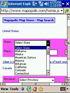
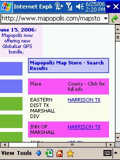
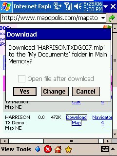
Anyhow, here I am looking for the map that covers the city Marshall in Texas. The search will tell me what county map I need - in this case Harrison county. It is small enough to be downloaded directly to my device.


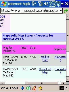
Demo maps can be used for nine days.

Mapopolis is the only provider that actually lets you download demo maps of the USA and Canada for free. Many times that nine day interval covers most if not all of your travel time, either on business or on holiday, and you may end up with a zero cost navigation solution altogether (Right, you still need a PDA and a GPS receiver).


And if you want to verify the map accuracy for your vacation location - easy, just download the map and have a look. What you see is what you will get if you later decide to buy it.


The new maps for Europe are not yet available for download as individual demo maps. However Mapopolis support have agreed to provide individual demo maps on a case-by-case basis. You can request a demo map of your county/shire or city by emailing support@mapopolis.com .

Maps are offered by county and can be stitched together directly on the device.

In fact that process is seemless - you select the maps you want to use, and Mapopolis will be able to route across them.


For general orientation Mapopolis also offer "Major Roads" maps (of US states and European countries) that again can be stitched together for cross country journeys.


In the most extreme version if you want to travel from London to Malaga all you would need for your journey would be the two "county" (shire or province) maps for London and Malaga, and the Major Roads maps for the UK, France and Spain.


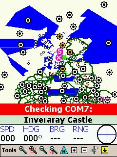
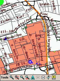
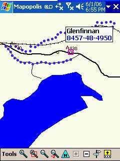
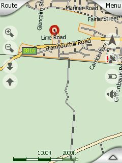
The example here shows some selected counties (mustardy chevrons) along with some mapping issues caused by the county concept. Some bodies of water do not have well defined borders and thus look a bit strange.

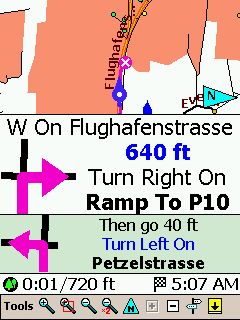
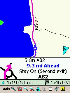
True intersection layout is shown in pictogram.

I don't know why other programs use pictograms that are misleading (for example using a right curve where a sharp right turn should be) . Mapopolis takes the true map data and abstracts it into a pictogram - to me that is brilliant.


Route optimisation - and on the fly, too.

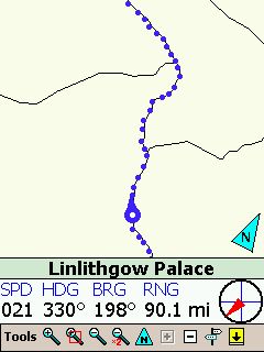
Mapopolis is one of the very few programs offering route optimisation, and it is the only one doing this dynamically, while you select the waypoints on the map. If you do not like a particular road choice, you can select an alternative road on the map and "route through" it. Or - as I did in the example below - enter two castles as stopovers for my trip from Fort William to the Falkirk Wheel.


This way of route planning and optimisation is much, much quicker than the standard practise of other vendors of showing the route instruction list, selecting a route part, and mark it as to be avoided.


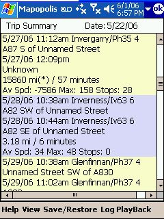
Additionally, Mapopolis allows to save, restore, and revert routes. If you have added waypoints ("Route Throughs") then those will be saved together with start and destination. "null" here is the name of a POI in Fort William, another sign for the sometimes poor quality of the Navteq POI data.


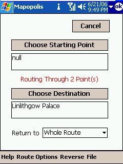
Unfortunately Mapopolis does not know the concept of permanent avoids, so if you have a problem spot in the maps - and you surely will find one - then you will have to do the manual reroute over and over again. Mapopolis actually recommend you start or end the route outside of your local knowledge area. Remember, mobile navigation is helping someone unfamiliar with the area to get from A to B, it is not designed to be challenged by your knowledge about local backroads and secret shortcuts.

Single map and navigation screen

Most applications are offering distinctly different navigation and map screens. There may be good reasons for that. However, Mapopolis chose to use just one combined screen, and it is working very well. By its very nature this approach is less finger/glove friendly, but it also allows to select map features (City and street details, POIs etc) much quicker while you are driving. Time will tell which concept is better.

The screen is redrawn while you move the map

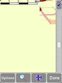
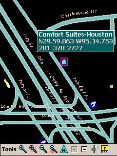
Screen redrawing is also relatively unique with Mapopolis. Try this little routine with whatever navigation program you are using:  switch to Map mode and drag the map across the screen (keep the pressure on the screen). Does it repaint immediately behind the pen ? I betcha it does not, and will only redraw when you release the pen or finger from the screen. An example (on the left) is TomTom.


Not so Mapopolis. It re-renders the map WHILE you are moving it around! To me this is a very important usability factor, and something extremely useful when you compile a route or are trying to find a place on the map.


I had to use that very feature while evacuating from Hurricane Rita, and having it made the difference between our lucky 5 hour escape to a safe location, and other motorists being stuck on the highway for 17 hours and more.


The only other program on the market doing that is iGO who don't officially have North America maps yet.

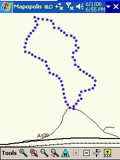
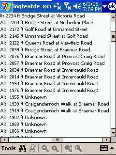
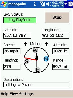
It logs you where you have been - and it shows.

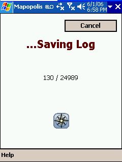
The breadcrumb trail in Mapopolis continues to be a very useful feature, and I find it difficult to understand why others have not implemented this functionality. When you switch on GPS logging a circular buffer of up to 256 kB records the GPS data every few seconds. If configured, this data is also displayed on the map as dots. You can then later play that log back, or simply retrace the dots.


You can also export the log to a text file, and then import it to whatever desktop program you are using for analysis.


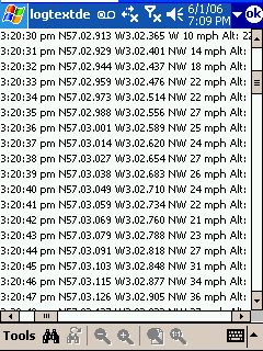
Recording plane trips (An all time favorite on the BIC list) is also possible but this will very quickly fill the data buffer, and Mapopolis also cap the recorded speed at 158 mph - you will have to calculate the true air speed from the coordinates. Altitude is recorded properly though.


Don't know what BIC stands for? "Because I Can". Make sure you obey the instructions of the flight attendants - if they want you to switch the receiver off then do that, don't argue about active and passive etc.

Announcing the side of the road

: Yes, the Text-to-Speech engine of Mapopolis is prehistoric. It only features one male voice (affectionately called "Drill Sergeant Jack") and is at times difficult to understand. However - it is pretty loud, only needs 2 MB of memory (TomTom's Loquendo based version in the newer GO's needs 300 MB for a single voice).


Most importantly, Jack will tell you to look for your destination on the right (or on the left) side of the road. This is extremely valuable for wide roads and for areas where the house numbers are artfully hidden (basically most of the US).

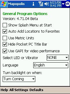
Turn backlight on only when needed

When you are driving at night even the best night color mode tends to be too bright. Mapopolis can take care of this for you. If there is no turn for a longer stretch of route then the backlight will be switched off. It will only be switched back on for an upcoming turn (about 1.5 miles ahead). This way it catches your attention, but only when needed.


It shows direction of search result, not just distance

Imagine you search for an address, but the resulting list contains multiple versions of your address. Most programs will either just list the addresses, or maybe add the distance to that destination.


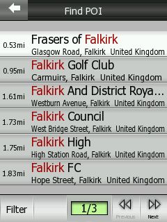
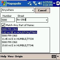
Not so Mapopolis. It is the only program I know that will also add the compass direction (the bearing), the city and the ZIP code to the result. So if you know that you are looking for a place to the south rather than to the east, and in Houston rather than Humble, you can make an educated guess that the first result is the one you wanted - even if that street address is far from unique.


The distance and bearing are calculated from a so called "search origin" - normally this is your current position, but you can also specify any other place on the map to be the search origin.
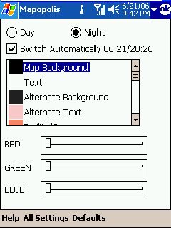
Automatic day/night switching

This seems to be en vogue this year, and Mapopolis have also attempted to implement this. It may sound trivial but is actually a very complicated task - you need to consider both the longitude and the latitude to find the times of sunset and sunrise - in Alaska or Norway there are regions where the sun stays up the whole summer and where it is dark a couple weeks, without any sun.


Add to that personal preference (do you switch your headlights on precisely at sunset, half an hour earlier, or half an hour later?) and it starts to look like something that should rather be left to the user or an ambient light sensor (like on the newer GO devices) to decide.


Anyhow, Mapopolis gives you the choice to do that switching automatically or manually, and it also informs you when it will switch over if you let it. The example here is for Houston, TX (30 degrees North).

Integrated map color editor

On the same screen you can manipulate the color selections for all UI elements, from streets to water bodies to standard and warning text. This will also give you the opportunity to change the horrible default Mapopolis color schemes to something much more ergonomical and - literally - easier to see.


Screen resolution and orientation:since a few versions Mapopolis runs equally well on portrait and landscape screens, and at 240x320, 640x480, and even 240x240 resolution. You can choose between three different font sizes as well as normal or bold text to find the best setup for your taste and eye strength.

It can do offroad navigation, too.

From "ye olden days" Mapopolis also features a "Pilot Data Pane" which shows heading, bearing, and distance to a destination. You can use that feature in a pretty unexpected way. Let's say you are going on a small walk around town or in a park or forest, and specify the location of your car as the destination.


Even when you cancel the routing, Mapopolis will remember that destination and duly show you the direction and distance to your car. Combine this with the breadcrumb trail and you have a "good enough" free solution for offroad navigation without the need to use proper topographic maps.

Mapopolis can also find places by Latitude/Longitude, so this should work for Geocaching too.


Of course this is no feature complete outdoor program (for starters you don't see topo maps) - it is only meant as an orientation help in very easy terrain!

Flexible announcement timing

The timing and frequency of the navigation announcement is always a good discussion starter when it comes to the shortfalls of your favorite navigation solution. Mapopolis have solved that problem uniquely - they let the user decide how much to announce, and when to do it.


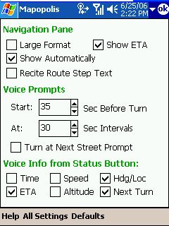
The announcement is not linked to a distance (like most other programs are doing) but rather to the time until the maneuvre. This makes perfect sense - a 200 metre warning may be ok in the city, but is very useless on the motorway. But a 20 second warning will always be a 20 second warning, calculated from your current speed.


What happens when you are sitting at a traffic light? Will it still tell you to turn left every 30 seconds? Of course not. When you are standing still, so is Jack. Brilliant.


Other unrelated remarks

Mapopolis is the only program not trying to take over the PDA - both TomTom and iGO are violating all possible MS guidelines there. In Mapopolis you can map hardware keys, but you can also keep their existing assignments. You can hide the top Pocket PC bar, but you can also keep showing it.


Back in version 4.02 Mapopolis also offered ClearRoute, a subscription based traffic information feed that was directly used to influence route calculation (See the old review). Back then the traffic service proved to be too far ahead of its time and Mapopolis had to cease the service because nobody was willing to pay for it. But with the advent of TMC in the US, and a greater acceptance of pay services overall maybe it is time to re-introduce that service.

The built in POIs are provided by Navteq and Dunn & Bradstreet (the latter for the US only). At best you can call them a mixed bag. While the older and more static stuff is mostly present, anything in the class of restaurant or petrol station is most likely inaccurate or simply missing. POIs are also not displayed very user friendly - they are just little dots on the map if you zoom out too much.


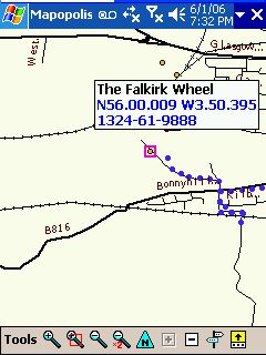
It is worth noting that Mapopolis was the only program to find the Falkirk Wheel. It is beyond me why such an important tourist attraction is not part of the TeleAtlas POI data. Or maybe it is, but neither TomTom nor iGO did include it in their respective POI sets.


Mapopolis then lost all the brownie points again by using a very strange route on the way back to Edinburgh. You see the breadcrumb trail in the picture above? The lower part, just below the railway, is what you see in the photo...


Custom POI integration - finally Mapopolis have understood the importance of that feature, and they do now fully support it - including proximity alerts. We will be offering a proper Mapopolis version of our Speed Camera database shortly.

Conclusion

Mapopolis held the crown as the fastest Pocket PC navigation application until iGO came along. But it is still substantially faster than any other programs.


The Mapopolis User Interface is ugly, no doubt about it. It is not finger friendly, and it is outright dangerous to try and operate Mapopolis while you are driving (so don't!).


But Mapopolis has a large number of unique features that - to me at least - continue to make it the best Pocket PC / Smartphone / Windows CE navigation solution on the market today.


At the end of the day, when the job needs to get done, I close my fancy bloatware programs and fall back to the lean and mean ugly duckling. Maybe this is a geek thing, maybe not.


I'll be interested to hear your opinion on this topic...If you know Mapopolis, look at it again. If you don't know it, have a first look.

References

Supplier Website

http://www.mapopolis.com/

Pocket GPS Contributors

Lutz Bendlin


Comments ?

Have any comments about this review ? Post them here.

GPS Shopping