 Review by Dave Burrows Review by Dave Burrows
The Magellan SporTrak is a well known series of handheld GPS Receivers, but Magellan have started to update their range of handheld's into colour models. First we saw the Meridian Colour, and now Magellan have updated a SporTrak to the SporTrak Color.
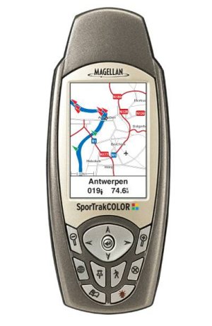
The SporTrak Color provides all of what you would expect from a SporTrak receiver, but with the added ability of having it all in a nice colour screen. The SporTrak Colour supports WAAS giving position accuracy to within 3 meters, caters for heavy foliage and canyoning with a quad helix antenna and gives you the best of both worlds.
Map wise, the SporTrak Color comes with a 10 MB North American or 11 MB European basemap, an additional 22mb for North America or 21mb for Europe allowing you to expand the mapping and upload detailed Magellan MapSend maps to the receiver to enhance the usability.
The colour screen gives a high contrast, full color 240x160 pixel display.
SporTrak Color also offers a built-in barometer, giving you an advance on the weather and a 3-axis compass for navigational accuracy no matter how you hold it. SporTrak's are always built tough, and the SporTrak Color is both rugged and waterproof.
In The Box
Inside the Magellan SporTrak Color box you will find the GPS Receiver, a user manual CD-Rom, a Quick Start Guide in various European Countries, an Accessory List, 2xAA Batteries, a Wrist Strap and PC Data Cable for connecting the SporTrak Color to a PC. The Quick Start Guide takes you through inserting the batteries, powering on the SporTrak Color, and going through the various Config menu's to configure the GPS Receiver.
 So how about the design ? So how about the design ?
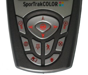
Well I must say I love it, the new slick look SporTrak looks and feels much better in the hand. The gray tones of the unit simply cry out with appeal, and the colour screen makes the unit look awesome. The keypad has been changed, it no longer feels spongy, and has a firm press feel to it, with the keys recessed into the center part of the keypad. The keys also light up which is great if you aim to use the SporTrak Color out in the dark, which when you come to think about it, a lot of fisherman and hunters would do. The only thing I do not like is the brightness of the screen. There is no way of increasing the brightness. Indoors the screen looks real nice, but outdoors I spent half the time looking at the screen thinking (is this a colour screen ?), as the display seemed to wash out quite a bit.
The SporTrak Color comes with support for 20 routes, 500 waypoints, 2000 track points and 12 built in co-ordinate systems and 76 map datum's including Latitude/Longitude, Universal Transverse Mercator, and Military Grid Reference System.
Battery Compartment
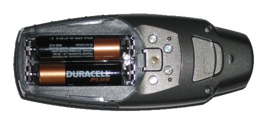
The back of the Magellan SporTrak Color has been redesigned, it's not quite the same as existing SporTrak's, with the PC Data Cable 4 plate connector's being lower down on the receiver, a much better contour to the back, and a much easier accessible battery compartment with a pull click rather than the original screw thread, which I prefer. There's nothing more annoying when having to turn a screw to take a battery compartment off when you need to do it quickly. The old catch was sure not budge which meant the batteries were kept secure, but I haven't seen any movement on the new battery compartment case, so I think it's just as durable as the old one.
Battery Performance
The SporTrak Color comes with advanced power management and the 2 AA batteries it uses Magellan say should power the receiver up to 14 hours of continuous use. Which to be honest, if you think about it, is quite remarkable. 2xAA batteries, color screen and 14 hours of use!
So what are the major differences between the SporTrak Color and the SporTrak Pro ?
 The major differences between the SporTrak Pro and the SporTrak Color is that the Color version now comes with an 11mb basemap as opposed to a 9mb basemap on the SporTrak Pro. The only part the Color drops in specification to the SporTrak Pro is the uploadable memory where the SporTrak Color has 21mb and the SporTrak Pro has 23mb. The major differences between the SporTrak Pro and the SporTrak Color is that the Color version now comes with an 11mb basemap as opposed to a 9mb basemap on the SporTrak Pro. The only part the Color drops in specification to the SporTrak Pro is the uploadable memory where the SporTrak Color has 21mb and the SporTrak Pro has 23mb.
The screen resolution is a lot better at 240x160 pixels on the SporTrak Color compared with the SporTrak Pro at only 160x104 pixels giving much finer map detail. The screen is also quite brighter which makes it easier to use.
The main differences are in the looks, and it's a welcome one, the new look looks more high tech and I hope that Magellan take this new look forward and use this on all future SporTrak's.
The keys are also laid out well and much better when compared to the original SporTrak's, and for people with large fingers, you will find the new keys much easier to press on the SporTrak Color compared to previous SporTrak models.
Which accessories are available for the SporTrak Color ?
| |
Belt Clip Carrying Case - SporTrak: Black
Specially designed for your Magellan® SporTrak® series GPS receiver, this sleek, stylish and rugged black neoprene carrying case features a clear vinyl widow that provides the convenience of using your SporTrak while it’s still in the case.
Bike Mounting Bracket – SporTrak
Conveniently mount your Magellan® SporTrak® series GPS receiver on your bicycle, snowmobile, or motorcycle. This easy-to-install mounting bracket securely holds your receiver for optimal viewing while on the trails, back roads, city streets or anywhere your adventure takes you.
Canvas Carrying Case – SporTrak/GPS 300 Series
This attractive black canvas carrying case is durable and padded to help protect your Magellan® SporTrak® Series or GPS 300 Series GPS receiver during rugged outdoor activities. The canvas carrying case easily attaches to your belt and features a zippered opening, Magellan logo and a special compartment to hold a set of spare batteries.
PC Data Cable – SporTrak/Meridian
Use this PC cable to connect your Magellan® SporTrak® or Meridian® series GPS receiver to your laptop, or desktop computer. The PC cable enables you to download highly detailed maps of streets, topography and more, using Magellan MapSend® software products, or other popular navigation software or points of interest from Magellan DataSend software.
PC Data Cable with/Cigarette Lighter Adapter – SporTrak/Meridian Transfer data from your laptop to your Magellan® SporTrak® or Meridian® series GPS receiver while supplying power to your receiver from your car, truck or boat. The PC data cable with cigarette lighter adapter enables you to download highly detailed maps of streets, topography and more, using Magellan MapSend® software products, or other popular navigation software or points of interest from Magellan DataSend software.
Vehicle Mounting Bracket – SporTrak
Strong suction cups conveniently secure your Magellan® SporTrak® series GPS receiver to the windshield of your car, truck or RV. Full tilt and swivel positioning enables optimal viewing of your receiver wherever your adventure takes you.
MapSend BlueNav Charts
Available on convenient preprogrammed Secure Digital (SD) memory cards and CD-ROM, MapSend® BlueNav charts offer a complete range of detailed marine cartography for your Magellan® Meridian® Gold, Marine, Platinum and Color, Magellan FX324 MAP and FX324 MAP Color, or Magellan SporTrak® Pro (CD-ROM only), SporTrak Pro Marine and SporTrak Color. Derived from Navionics® Gold charts, MapSend BlueNav charts are the most advanced marine cartography available, providing large, highly detailed coverage areas and enhanced marine navigation information, including marine currents, tides, port services and much more.
MapSend Streets Europe / Destinations Canada / US / WorldWide Basemap Detailed street-level maps of Europe make GPS navigation in the region even easier with your Magellan® Meridian® series, SporTrak® Pro, SporTrak Pro Marine, SporTrak Map, SporTrak Color, or MAP 330 handheld receiver. |
Screenshots
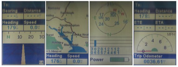
Unfortunately there is no easy way to take screenshots of a Magellan screen, so here goes, these may appear a little blurred and washed out, but are actual photos taken in a controlled environment indoors, hopefully it shows you the depth of colour used so you can see what to expect when you purchase the SporTrak Color.
MapSend - Adding Mapping to your Handheld GPS
Create your own waypoints and routes on your PC, edit and download them to your GPS receiver for use on your adventure. Save thousands of routes on your PC for recording your every journey. Plotting your current position in relation to surrounding landmarks is fun and easy, and your GPS search function will find street addresses and points of interest, quickly and safely guiding you to those locations.
- MapSend is currently available seven different flavours:-
- MapSend BlueNav Charts
- MapSend Streets & Destinations Canada
- MapSend Streets & Destinations in the US
- MapSend Streets Europe
- MapSend Streets in the US
- MapSend Topo in the US
- MapSend WorldWide Basemap
Magellan also offer DataSend and DataSend Europe which allow you to create your own personal charts. The unique DataSend Europe software allows you to download your routes and waypoints from your GPS receiver to your PC, to easily record your journeys and edited them for future use on a new adventure. For use with your Magellan SporTrak, GPS 315, GPS 320 or SP24 receiver.
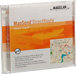
MapSend DirectRoute add automated street routing with turn-by-turn directions to your Magellan ® GPS handheld receiver!
Magellan MapSend ® DirectRoute TM is a major advance in mapping software, guiding you to your destination by adding detailed street maps, automated street routing, turn-by turn visual guidance and audio prompts to the Magellan GPS handheld receiver you currently enjoy for outdoor recreational adventures.
Now you can use automated street routing to navigate to your destination, go exploring, mark waypoints and track points in the outdoors and find your way home all on a single Magellan GPS handheld receiver.
MapSend DirectRoute makes getting where you're going even easier using your Magellan Meridian ® Color, Meridian Platinum, Meridian Gold, or Meridian Marine, SporTrak ® Color, SporTrak Pro, or SporTrak Pro Marine GPS handheld receiver.
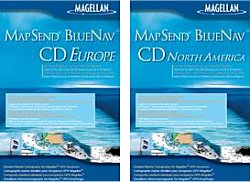
MapSend BlueNav Europe includes 191 local European navigational charts, offering a complete range of detailed marine cartography for your Magellan ® Meridian TM Gold, Marine, Platinum and Color or Magellan SporTrak Pro , SporTrak Pro Marine and SporTrak Color. Derived from Navionics ® Gold TM charts, MapSend BlueNav charts are the most advanced marine cartography available, providing large, highly detailed coverage areas and enhanced marine navigation information, including marine currents, tides, port services and much more. MapSend BlueNav North America includes 83 local North America navigational charts, offering a complete range of detailed marine cartography

MapSend WorldWide Basemap software enables you to create a basemap for any region of the world and upload it to your mapping Magellan ® GPS receiver. Adding WorldWide basemaps to your Magellan GPS receiver does not erase your built-in basemap -- it enables you to add basic reference map coverage for areas not covered by the built-in map. New basemaps can be loaded and saved via a PC to GPS cable from your PC to your Magellan Meridian ® series handheld (requires an optional Secure Digital (SD) memory card), directly to the SD card using a card reader/writer, or directly to the memory of your Magellan SporTrak ® Pro, SporTrak Pro Marine, SporTrak Map, SporTrak Color or MAP 330 GPS receiver.
Each basemap region you define contains the essential basic map features such as cities, highways, waterways, railroads, national boundaries and shorelines. WorldWide Basemap also includes basic topography contours, which can help you stay oriented to your environment and find Points of Interest.

MapSend Streets offers detailed street-level maps of Europe make GPS navigation in the region even easier with your Magellan ® Meridian ® series, SporTrak ® Pro, SporTrak Pro Marine, SporTrak Map, SporTrak Color, or MAP 330 handheld receiver.
MapSend ® Streets Europe contains highly-detailed maps that can be easily downloaded from your PC to your handheld GPS receiver for a fun and simple way to navigate.
Create your own waypoints and routes on your PC, edit and download them to your GPS receiver for use on your adventure. Save thousands of routes on your PC for recording your every journey.
MapSend Streets comes in a variety of formats including a MapSend Streets Europe, MapSend Streets & Destinations Canada, and MapSend Streets & Destinations US.

DataSend Europe - Create your own personal charts. The unique DataSend TM Europe software allows you to download your routes and waypoints from your GPS receiver to your PC, to easily record your journeys and edited them for future use on a new adventure. For use with your Magellan SporTrak, GPS 315, GPS 320 or SP24 receiver.
FREE Nautical Waypoint databases
Take advantage of FREE regional nautical waypoint databases*. Download waypoint coordinates for harbors, lighthouses and more, then edit and add your own waypoints to create personal charts on your PC. Download these .zip files and open and edit the waypoint database files with Personal Mapping System Waypoints & Routes.
DataSend (US) -
contains coordinates for more than 500,000 points of interest, including harbors, lighthouses, wineries, museums, parks, campgrounds, hunting and fishing spots,restaurants and much, much more.

MapSend Topo (US)- The most advanced GPS topographic software available, Magellan ® MapSend ® Topo In the US maximizes the navigation capabilities of your Meridian ® series, SporTrak ® Pro, SporTrak Pro Marine, SporTrak Map, MAP 330 or MAP 330M handheld receiver.
The MapSend Topo in the United States software contains highly-detailed 3D topographic maps that can be easily downloaded from your PC to your handheld GPS receiver for a fun and simple way to navigate.
Map details include streets, lakes, rivers, coastlines, parks, railways and points of interest for the entire United States. You choose the regions and level of detail to download for maximum memory efficiency. The data can then be updated or overwritten with new map regions. Topography derived from the U.S. Government Digital Elevation Model (DEM), provides elevation details for every location on the map.
Connecting the Magellan to a PC or Pocket PC
Magellan ship a PC data cable in all their GPS Receiver boxes so you can connect the Magellan GPS Receiver to a PC which has a DB9 (9 pin Serial) connector. These are pretty much standard on all computers, except some newer computers tend to favour USB or Firewire over Serial.
You can also connect a Magellan GPS Receiver to a PDA like a Pocket PC or Palm PDA. You can do this by purchasing a cable set from PC-Mobile. The cable should comprise of two parts, the first part is the cable that screws onto the back of the Magellan like the one below.
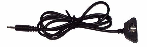
The second part of the cable will have a 3.5mm socket on one end which will connect with the 3.5mm plug (left) and the other end of the cable will have a PDA connector. This then allows you to use your favourite GPS Receiver on your favourite PDA and utilise a whole host of other mapping products anything from Topographical products like Fugawi, OziExplorer, Memory-Map to Street Routing software like TomTom Navigator, PowerLOC Destinator and you don't then need to purchase a second GPS Receiver if you're primary use going forward will be on the Pocket PC!
Summary
The SporTrak range is a good range of GPS Receiver, and the SporTrak Color build upon this with the addition of a new colour screen. The receiver is small, lightweight and has all the standard features that you'd want in a handheld GPS Receiver, the only thing lacking from this receiver is to be able to expand the store space allowing for larger maps to be downloaded with MapSend. If the amount of space for map data is crucial, then you may want to look at the Meridian Color which gives you the ability to add SD card storage to the Receiver. However if you would like a more rugged, stylish GPS then the SporTrak Color will be the one for you. If only the SporTrak Color could take SD cards, then this really would the best looking and feature rich handheld GPS around.

|


