Reviewed By |
Matthew (MaFt) Morley |
 |
| Review Date |
16th September 2011 |
| Manufacturer |
Magellan |
RRP |
€149.99 (£130) inc VAT |
|
 I’ve enjoyed Geocaching for a number of years now; as have my six year old son (although he refers to them as treasure hunts), my four year old daughter (if the terrain is suitable) and my wife (if it’s warm and sunny...!). So, when I was asked to review the Magellan eXplorist GC, a handheld GPS device specifically for Geocaching, I agreed to it without hesitation. I’ve enjoyed Geocaching for a number of years now; as have my six year old son (although he refers to them as treasure hunts), my four year old daughter (if the terrain is suitable) and my wife (if it’s warm and sunny...!). So, when I was asked to review the Magellan eXplorist GC, a handheld GPS device specifically for Geocaching, I agreed to it without hesitation.
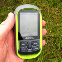
The eXplorist GC is waterproof to IPX7 and rubberised for improved grip when outdoors in all the various forms of the Great British weather. The ‘handle’ at the bottom of the unit allows it to be easily fastened to a lanyard to carry it around your neck when you don’t need to hold it.
In the box is the device itself, a USB cable, instruction manual and 2 Lithium Energizer batteries. It makes a change to get some decent batteries with a device and the inclusion of a USB lead is good too. More and more manufacturers seem to be cutting costs by simply not providing a USB lead - admittedly most people will have one, but not everyone!
To get the best experience from the eXplorist GC you need a Premium Membership at the Geocaching.com website which costs $30 (£19) for one year or $10 (£6) for three months. Magellan provide you with a code that gives you thirty days free Premium Membership. Without the Premium Membership you are limited to what data you can download from the Geocaching website - you can download the cache locations and names but they will missing the recent logs, hints, full description etc.
When you are logged into the Geocaching.com website you can search a location and copy caches directly to the device using a browser plugin for Magellan devices - this makes transfer very simple but means you have to copy them one at a time. According to the instruction manual this is how you need to do it. However, with a bit of digging in the Geocaching forum I found out about ‘Pocket Queries’ (http://support.groundspeak.com/index.php?pg=kb.page&id=118) - this allows you to set up certain criteria and you will be emailed a ‘.GPX’ file containing all the matching caches. So you could set up a ‘Local Caches’ PQ so that once a week you are emailed all the caches in your vicinity within a certain radius.
On the website you can select multiple caches to download but it downloads these as ‘.LOC’ files which the eXplorist uses as waypoints and not caches so you don’t get any of the cache information.
Enough about the Geocaching website, the Magellan is now fully loaded with my local caches and it’s time to go hunting.
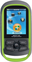
 The eXplorist GC uses a 4-direction ‘nipple’ for navigation, which also doubles up as a ‘select’ button. Four other hardware buttons are present too for ‘back’, ‘menu’, ‘zoom out’ and ‘zoom in’. It is easy to use although with gloves or cold hands it can be tricky to control the nipple. The eXplorist GC uses a 4-direction ‘nipple’ for navigation, which also doubles up as a ‘select’ button. Four other hardware buttons are present too for ‘back’, ‘menu’, ‘zoom out’ and ‘zoom in’. It is easy to use although with gloves or cold hands it can be tricky to control the nipple.
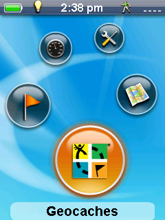
The main menu is straightforward with Geocaches, Waypoints, Dashboard, Tools and Map.
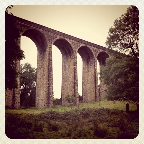
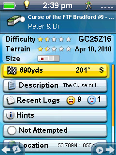
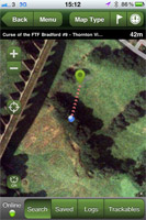
On a windy, cold and wet day over Summer I fired up the eXplorist GC and clicked the Geocaching icon on the main menu. On the main menu I selected Geocaches and a list of installed caches were shown in alphabetical order, along with little icons for the size of the cache - similar to those shown on the main website. Scrolling down long lists is quite simple; once you hold the nipple downwards for a few seconds it starts to scroll through the list at a much faster speed and you can estimate where you are with the marker on the right side of the screen - much like you would with a long web page. You can also filter and reorder the list for example to show only certain types of cache, certain difficulties or size etc and even sort alphabetically, by date or type. We decided to head for one near the wonderful Thornton Viaduct (Geocaching ID: GC25Z16) that we’ve passed many times but never got around to finding it!
We parked up and I added a new waypoint at the car so I could find it again afterwards. On the map screen simply press Menu then select Add Waypoint - you can also add details, choose an icon and then save it. Entering a name for the waypoint is quite tricky and time consuming - the on-screen keyboard has all the numbers and a qwerty keyboard as well as loads of punctuation. It is not a touch screen device so selecting letters requires you to use the nipple and more than often you accidentally press it in instead of pushing it to the side to move to a different letter. You then have the same issue when trying to get to the delete button to remove the erroneous letter. It is actually quite frustrating! We then set off walking towards the public footpath that was mentioned in the details of the cache.
It was here that I met my first issue. The installed maps are road maps - no terrain, rivers, streams or footpaths are shown on the device. So for off-road caches, which are the vast majority in my experience, you may as well be looking at a blank screen that just says “go that way”. It’s not very helpful when the screen you are looking at shows no ‘markers’ for you to work out the best way to go. We took a wild stab at the bottom of the initial steep incline which actually took us onto a golf course - we got a few funny looks but carried on anyway, it was a public footpath after all! As we walked on alongside a large, barbed-wired fence that ran parallel to a fairly large stream it became clear that we were on the wrong route. Had the water been shown on the maps we would have taken a different route as we could have seen that this would be in the way of us reaching the cache. So we back-tracked and went to the other side of the stream.
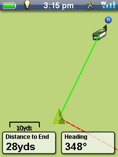 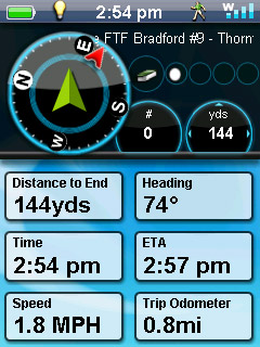
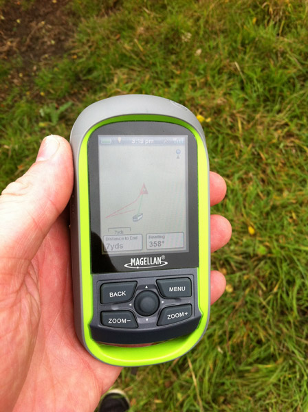
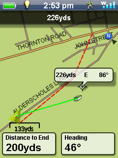
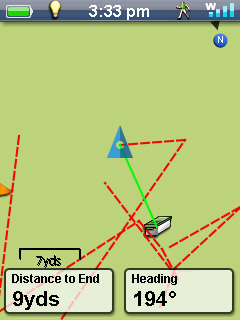
While you are hunting for a cache you can go to the Dashboard option on the main menu for various stats about your trip. This shows your speed, a compass, the cache name, distance to the cache, heading and ETA. Pressing Menu while in the dashboard also allows you to customise which fields are shown here too.
When you are on the map screen you can press Menu to get to various other options and settings. You can choose to overlay a compass over the map screen which can be helpful and also start/stop the trip tracking. You can add waypoints, view the nearest caches and choose which data fields are shown on the map - distance, elevation, ETA, heading etc.
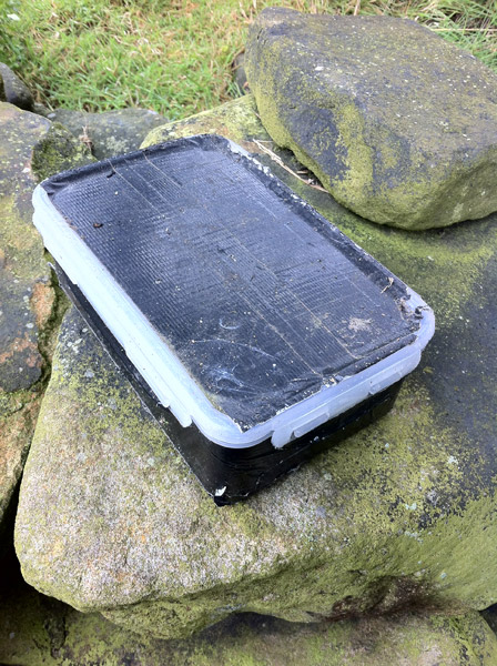
 We were finally on the right track, although the large bull watching us was a little bit unnerving... As we got closer to the cache the eXplorist GC gave an audible beep so we knew we were pretty much on top of the cache. It was here that the second snag became even more apparent - the eXplorist GC has no digital compass. In a car SatNav a digital compass isn’t really required - at normal driving speeds, and even as slow as a few miles per hour, the device can pretty accurately calculate your heading. The average walking speed is around 3mph and, when walking, the eXplorist GC calculates your heading quite accurately; but when you’re hunting for a Geocache you tend not to be moving around that much. The eXplorist GC is marketed as a Geocaching specific device, so the lack of a digital compass seems to be quite an oversight on Magellan’s part. Part of me even wonders if they even tested the device with a real cache where they didn’t know exactly where to look. Without the digital compass it was pretty much impossible to use the eXplorist GC to locate the cache - I knew I was close but unless I started walking at quite a pace for about 5-10 meters (for the heading to be updated) I didn’t know which direction to be looking at for the cache. After 30 minutes overturning practically every stone from an old wall and dodging an awful lot of cow poop I almost gave in... I was about to mark it on the device as a ‘did not find’ but then decided to cheat. I pulled out my iPhone and launched the Geocaching app - the app uses the phone’s digital compass and this made such a difference! I found the cache within a few minutes as I could actually work out where I was in relation. However, the eXplorist GC has onboard maps so in areas of poor data connection or when you are abroad the iPhone app wouldn’t be much use as the maps wouldn’t load! We were finally on the right track, although the large bull watching us was a little bit unnerving... As we got closer to the cache the eXplorist GC gave an audible beep so we knew we were pretty much on top of the cache. It was here that the second snag became even more apparent - the eXplorist GC has no digital compass. In a car SatNav a digital compass isn’t really required - at normal driving speeds, and even as slow as a few miles per hour, the device can pretty accurately calculate your heading. The average walking speed is around 3mph and, when walking, the eXplorist GC calculates your heading quite accurately; but when you’re hunting for a Geocache you tend not to be moving around that much. The eXplorist GC is marketed as a Geocaching specific device, so the lack of a digital compass seems to be quite an oversight on Magellan’s part. Part of me even wonders if they even tested the device with a real cache where they didn’t know exactly where to look. Without the digital compass it was pretty much impossible to use the eXplorist GC to locate the cache - I knew I was close but unless I started walking at quite a pace for about 5-10 meters (for the heading to be updated) I didn’t know which direction to be looking at for the cache. After 30 minutes overturning practically every stone from an old wall and dodging an awful lot of cow poop I almost gave in... I was about to mark it on the device as a ‘did not find’ but then decided to cheat. I pulled out my iPhone and launched the Geocaching app - the app uses the phone’s digital compass and this made such a difference! I found the cache within a few minutes as I could actually work out where I was in relation. However, the eXplorist GC has onboard maps so in areas of poor data connection or when you are abroad the iPhone app wouldn’t be much use as the maps wouldn’t load!
 Once found I used the eXplorist GC to mark it as such and added my field note. Well, I tried to add my field note... It’s hard to enter anything meaningful using the nipple/keyboard method. In the end, again, I cheated and added the field note on my iPhone. If you are planning on using this device I would certainly recommend having a backup notebook and pencil then adding your field notes on the website manually. You can, actually, upload the field notes directly from the device to the website. However, again, the manual makes no mention of this capability. Once found I used the eXplorist GC to mark it as such and added my field note. Well, I tried to add my field note... It’s hard to enter anything meaningful using the nipple/keyboard method. In the end, again, I cheated and added the field note on my iPhone. If you are planning on using this device I would certainly recommend having a backup notebook and pencil then adding your field notes on the website manually. You can, actually, upload the field notes directly from the device to the website. However, again, the manual makes no mention of this capability.
The eXplorist GC uses a SIRF-Star 3 chipset and claims an accuracy of 3m - it does seem very accurate too. There are plenty of options and settings too to personalise the device to your specific needs. Things such as which POIs to display on the map and whether to show the name of the caches on the map are nice touches. You can also choose heading up or north up on the map, choose whether or not to log your route and show the track on the map. There are 14 coordinate systems to choose from including standard forms of lat/lon (decimal degrees, degrees minutes seconds etc) as well as OSGB, German grid, Irish grid, a couple of different Swedish grids and more...! Quite a selection. I also lost count of the number of Map Datum options available - there are around 60 or so and the default is WGS84. You can also choose magnetic north or true north.
Now, I like a challenge and if I see a claim I will aim to prove (or disprove) it. The Magellan eXplorist says it is IPX7 waterproof. IPX7 means that “Ingress of water in harmful quantity shall not be possible when the enclosure is immersed in water under defined conditions of pressure and time (up to 1 m of submersion)”. The test carried out for this is to immerse the product in water of a depth of up to 1m for 30 minutes. So, I set up my lab... OK, I filled up the washing up bowl and chucked the eXplorist GC into it for half an hour. I left it turned on too so I could make sure it was all working and go through the menu options etc.
After 15 minutes in 15cm depth of water the device went off and wouldn’t turn back on again... I initially panicked and opened up the back battery cover to see that the batteries were, in fact, bone dry. The USB port was, however, filled with water. I blew the water out and then the device came back to life again shortly after. However, an hour or so later the eXplorist GC would only work on external power through the USB lead and seemed to be ignoring the fact that there was a pair of batteries installed. And yes, I did check they weren’t flat!
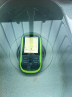
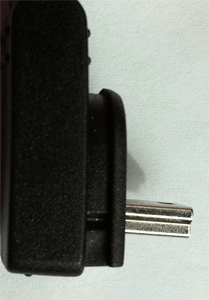
I can also see moisture building up behind the screen so clearly it is not waterproof to IPX7 standards. A shame really, as being waterproof and rugged is great for outdoor types - I wouldn’t be too happy hanging it around my neck in the rain either as that would leave the USB cover facing the rain.
Perhaps a new model could put the USB port behind the battery cover as it uses a more secure locking mechanism coupled with a rubber seal and no water got through that.
In conclusion, the eXplorist GC is a very capable device. Beginners will have no trouble using it and the more advanced users will enjoy digging deep into the options and fiddling away. The poor design of the USB cover is a massive let down as the waterproofing is one of the devices main selling points. It can be fiddly at times to enter text but often a simple ‘found it’ or ‘did not find’ marker is enough and comments can be added easily on the website anyway. The screen is nice and clear even in sunlight and battery life does appear to live up to the claimed 17 hours from 2 standard AA batteries. While the manual could do with some improvements, the community in the Geocaching.com forums are quick to help should you need anything.
All in all it is a good device at a good price and recommended for those who require long battery life and something suitable for using outdoors in all weather (just don’t give it a bath...).
|