 Review by Dave Burrows Review by Dave Burrows
Introduction
InfoMap Navigator is a program developed by Directions Ltd who are a UK based Navigation Company. InfoMap Navigator is a cheap alternative to PDA based systems where you are looking to pay at least £100 for a map of the UK for instance, InfoMap Navigator comes in at a lot less than this and provides just as much detail and features as a PDA Navigation system, if not more so. The downside is that PC's and Laptops still aren't small enough to use in-car, especially when you have a full car of passengers, but many do choose to use PC based systems like InfoMap Navigator, partly due to the price, secondly because they already have the hardware technology needed (except for a GPS USB Mouse) which can be picked up at £100 and more importantly it gives them exactly what they want without having to shell out a hefty £500-600 on a complete new system.
Directions Ltd currently offer two versions of InfoMap Navigator. The first is a UK map version that comes installed at 648mb on one CD, and the second is a complete European Navigation product that comes on 5 CD's. In this review we will be mainly reviewing the UK version, but will touch upon the European version in the review.
InfoMap Navigator Features
InfoMap Navigator has a wealth of features which make it one of the better PC/Laptop based Navigation products on the market today.
 Voice Guidance Voice Guidance
- Step by step voice guided navigation as you drive
- Map rotation (north - up or driving direction)
- Layers
- every street in Britain (over 420,000 Km of roads)
- searchable index of 700,000 streets
- 30,000 place names
- 2500 rail and commuter stations
- administrative boundaries - county, district
- hospitals, universities, airports
- parks, woodlands
- golf courses and sports centres
- lakes, rivers and canals
- places of interest
- Postcode Locator
- 1.7 million postcodes can be located on the map (now includes Northern Ireland Postcodes)
- improved accuracy
- validate postal addresses
 Route Planner Route Planner
- detailed routing using every street in Britain
- one way streets and other driving restrictions
- select a waypoint from the map, Postcode Locator or any other database
- choose stops along the route
- display the shortest/quickest route on a detailed map and print it in colour
- print a full itinerary
- calculate fuel consumption, mileage and journey cost
- GPS - Satellite Navigation
- monitor your position on the map
- map is adjusted automatically
- record and replay a journey
Installing InfoMap Navigator
 Installing InfoMap Navigator is pretty easy. Just follow the on-screen wizards, and you'll be completed in a short while it takes to copy the maps to your hard drive. Installing InfoMap Navigator is pretty easy. Just follow the on-screen wizards, and you'll be completed in a short while it takes to copy the maps to your hard drive.
Installing the UK maps takes up 684mb of disk space.
Installing the European maps take considerably more considering that there are 16 countries! Expect for 16 European countries to a whopping 5.5 Gigabyte's worth of space!
You can see the various map sizes from the two Navigator Map install screens on the right hand side.
Once you start installing the maps, that's it. No configuration to do on install. 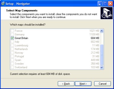 Once the maps have completed copying to your hard drive, you can eject the CD and not have to worry about using the CD's again, as everything you need is now installed to your hard drive. This is unusual because most applications will require you to have the CD continually inserted into the CD Drive on your Laptop when using maps and navigation, so being able to install all the maps is really a breath of fresh air, especially seeing that most laptops now come with 30-40Gb of disk space. Once the maps have completed copying to your hard drive, you can eject the CD and not have to worry about using the CD's again, as everything you need is now installed to your hard drive. This is unusual because most applications will require you to have the CD continually inserted into the CD Drive on your Laptop when using maps and navigation, so being able to install all the maps is really a breath of fresh air, especially seeing that most laptops now come with 30-40Gb of disk space.
Additional Requirements
One thing you need to make sure is because you are going to use your laptop in-car, you need a suitable mount for your laptop that will also cushion bumps so you don't do damage to the laptop or hard drive, but also you will need a power charger. Most laptops will only last for a couple of hours use on battery, and this really isn't enough in most navigation environments to get you to your destination. Laptop charger cables can be rather expensive, most come in at around £50-60, the other alternative is that you could use a mains charger system in-car which basically is a larger battery that gets charged in-house, or whilst your driving, and gives you a 3-pin plug support so you don't have to worry about purchasing an in-car charger. These again are not cheap, and do require more space in-car, so you can quickly find that your front passenger seat is unavailable when you have this sort of system installed. Fine for most if you don't mind passengers being in the rear of the car, but if you want something a little smaller, then perhaps you need to look at a PDA based system, or an integrated dashboard system.
 Configuring Configuring
Configuring InfoMap Navigator is quite easy. Directions Ltd have chosen most of the defaults for you, so really all you need to do is tweak InfoMap Navigator a little to your needs.
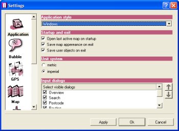
In the Applications screen to the right you will see that you can change the way the application looks in the Application Style. you can also choose the Startup and Exit features like the saving of map appearance and user objects. You can also specify whether you want to use a metric based system or imperial. Most of UK Roads still use imperial, so although Metric is default you may want to change this to imperial to give things like Yards rather than meters. Sometimes I think that's strange, that although we changed to metrics many years ago, we still use Yards on our roads today. Quite strange, and probably even stranger for foreign visitors to the UK.
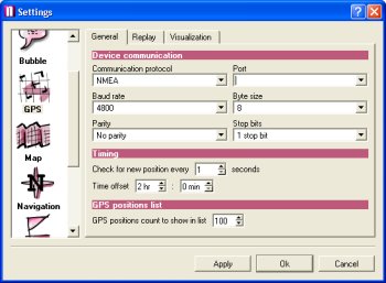
The next icon GPS, allows you to configure all aspects of the GPS Receiver. You can only choose NMEA for the protocol. Unfortunately there is no SiRF support here. You can also change the baud rate from 110 baud right the way up to 256,000 baud, which should cater for all GPS Receivers on the market today.
You can set the COM port which the GPS Mouse is using, the Byte Size, Parity and Stop Bits which usually don't need any tweaking. Another great feature is you can change the new position update down to 1 second which means you will always be accurate on-screen.
Under the GPS screen, you will also see a REPLAY tab which allows to replay a journey/trip, and also the Visualisation tab which allows you to see things like coordinates, satellite  count, altitude, speed, time, course etc. You can also set a GPS Trail (like a breadcrumb trail) in InfoMap Navigator and limit it to X positions. The current default for this is 100 which should be enough for small journeys and can be changed. count, altitude, speed, time, course etc. You can also set a GPS Trail (like a breadcrumb trail) in InfoMap Navigator and limit it to X positions. The current default for this is 100 which should be enough for small journeys and can be changed.
The next icon is Map which allows you to set the panning area of the map, maximum zoom levels, mouse sensitivity, scale adjuster and size of map icons. The Panning Area basically allows you to set the percentage of screen that panning will occur in.
The Zoom limit allows you to change the amount of pixels per meter which appear in the most detailed zoom, the default for this is 3 pixels per meter.
Mouse Sensitivity allows you to change the sensitivity in the smallest zoom rectangle size, selection and bounding box for elliptic selection.
Scale adjuster basically allows you to change the distance to make it more of a real world measurement. Current default is set to 20mm. Lastly the icon size is for Points Of Interest etc.
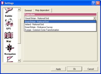
The Map icon also has another tab called Map Dependent which allows you to select the datum to be used. You can configure the following datum's:-
- Great Britain - National Grid
- Ireland - National Grid
- Great Britain - Ordnance Survey
- Europe - Common Cone Transformation
The next icon Navigation includes the ability to set Voice Navigation. Under here you can set Voice Notification to 1km before a maneuver, Voice Notification 500 meters before a maneuver, Voice Notification 100 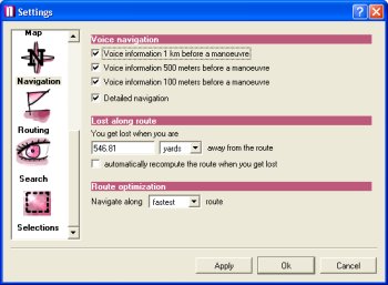 meters before a maneuver and also for Detailed Navigation. meters before a maneuver and also for Detailed Navigation.
Under the Navigation icon you also have the ability to set the Lost Along Route settings. This is a good feature and you can say that you get lost 546 yards from the last turn. You also have the ability to automatically re compute the route when you get lost.
Route optimisation is also another feature that allows you to navigate along the route by choosing:-
- Shortest Route
- Fastest Route
- Cheapest Route
The default for this is fastest route 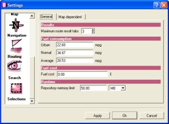 selected on install. selected on install.
The Routing icon allows you to change the cost of routing allowing you to customise how you want InfoMap Navigator to route you. In hear you can set the cost as follows:-
- Urban mpg (default=22.60 mpg)
- Normal mpg (default=34.87 mpg)
- Average mpg (default=28.53 mpg)
- Fuel Cost
- Running Time (Repository Memory limit in Megabytes)
Under the Map Dependent tab, you can also change the road speeds to fully customise how you will be routed. Some people prefer being routed solely along motorways, some A roads, some B roads, some a mixture of all three, and some really don't  mind, so here's the chance of customising how you would prefer to be routed. mind, so here's the chance of customising how you would prefer to be routed.
Directions Ltd have thought of everything here, allowing you to customise the speeds of the following roads:-
- Motorway
- Major Road
- Other Major Road
- Secondary Road
- Local Connecting Roads
- Local Road of High Importance
- Local Road
- Local Road of Minor Importance
- Boat Ferry
- Train Ferry
Directions Ltd have also thought about keeping the system working as fast as possible when performing complex database searches for  addresses and postcodes and allow you to customise whether you want InfoMap Navigator to run faster or slower and give you more detail. Obviously the more search results you bring back, the slower it will take to search. addresses and postcodes and allow you to customise whether you want InfoMap Navigator to run faster or slower and give you more detail. Obviously the more search results you bring back, the slower it will take to search.
In hear you can configure the Database Search features to:-
- Maximum search results (default=3)
- Maximum records found (per category) (default=100)
- Maximum distance form a street when searching along route (default=1km)
The final configuration screen (phew), gives selection ability. When you plot a route and navigate a route, certain roads will change colour depending on the route you have calculated, and you have the full ability in this 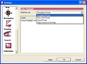 screen to configure how you want these roads seen. screen to configure how you want these roads seen.
You have the ability to set:-
- Navigation Route
- Part of the Route
- Found Route
- Object found on the Map
With each option you can change the colour that you would see using a standard pop-up colour palette.
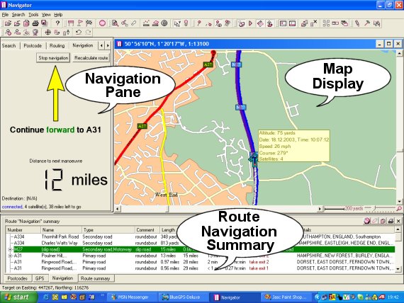
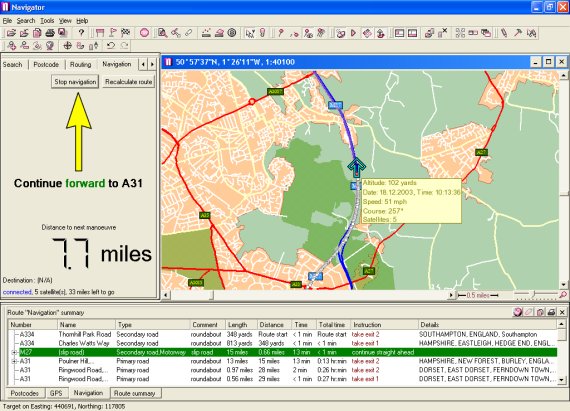
Navigation Panes
InfoMap Navigator has three window panes that make up the screen. The first being the Navigation Pane, the second being the Map Pane, and the third being the Route Navigation Summary Pane. When you are not in Navigation mode, the Navigation Pane gives you the ability to plan and input your routes using the Search facility, Postcode, Routing and Navigation tabs.
Maps
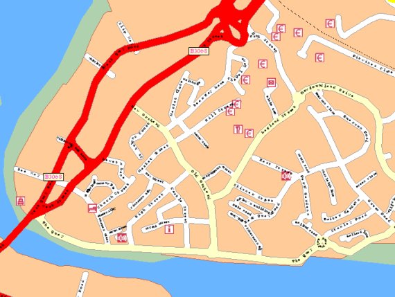
The maps are provided courtesy of TeleAtlas, which are usually considered cheaper than that of NavTech maps, but tend to offer more features and bang for buck, and keeps the product price down. Other companies that use TeleAtlas maps are TomTom, TeleType and soon to be Navman. The version of InfoMap Navigator that we are reviewing is version 1.3.2 Build Date July 9 2003 and built on Qt version 3.1.2 libraries. TeleAtlas's maps are always very clean, and you can see on a close zoom here various road names etc.

Map Direction
With InfoMap Navigator like many GPS Navigation packages on the PDA front, you have the ability to change the view. You can either have North as Up, which means you may see yourself traveling East or West on the map, but the map orientation always stays constant, or you have the ability of changing it so that the direction you are driving is always up the screen, which sometimes makes it a little easier on navigating for when you have to look at the map, you don't have to start thinking about where you are in relation to what you see outside of the car.
Points Of Interest
The Points Of Interest that InfoMap Navigator has is extensive, but there are still lots of POI's missing. This isn't just a quirk with InfoMap Navigator, but a problem more with the data provided by TeleAtlas. Most town centres you will only see around a dozen POI's which really isn't enough and I'm sure will be extended over time.
One thing you can do is right click a particular position on the map and select Find Nearest, and this will start searching for nearby Points Of Interest and display these in the bottom window. Simply Right Clicking on these, you can then select Routing, Set Navigation Destination, and this will allow you to route to that particular Point Of Interest. This I found worked well, but there was no way of searching for a particular Point Of Interest, like Burger King, or Travel Inn to see where the nearest one may be.

Full Screen Mode
InfoMap Navigator allows you to experience the best of both worlds. First of all you can have all the information you want on screen including the navigation pane, journey directions and the map, or if you want, you can just go to map view in full screen mode.
Postcode Routing
InfoMap Navigator gives full support for up to 1.7 million UK postcodes. Entering an address by means of postcode alone in InfoMap Navigator really is easy, just go to the Postcode tab in the Navigation pane, and it will take you to the segment of houses/buildings where the FULL postcode you entered resides on the map. Entering a postcode of BH15 brought up all of the following locations.

 Voice Navigation Voice Navigation
InfoMap not only gives you support for maps, creating routes, and directing you to your destination, but it is one of the first PC applications to give you Voice Navigation support with a female voice saying "roundabout, in 500 meters, take the first exit". You can see how it sounds by clicking on the sound icon to the right to launch a WAV file from InfoMap Navigator.
Routing Quality
InfoMap Navigator has what I must go on record to say one of the best routing algorithms that I have seen so far in applications I have reviewed. I always like to drive the quickest routes and InfoMap Navigator matched the roads like for like that I traveled on which made InfoMap Navigator a superb application for me.
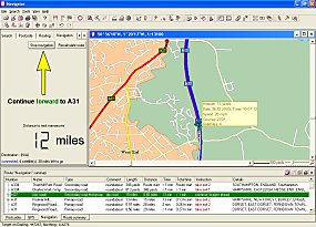
Re-Routing and Auto Re-Routing
InfoMap Navigator has a Re-Route facility like most Satellite Navigation systems. With Re-Route set as default, a pop-up dialog box will appear and say "I think you are lost, would you like to re-route ?". If you click OK, then it will compute a new route for you. If you select the Automatic Re-Route option, then InfoMap Navigator will Re-Route you when it thinks you are lost (or off course). However the Re-Routing detection is a little slow on InfoMap Navigator. You will see by the map below. I started my journey on the bottom roundabout (the white track is where I drove) and the yellow track is where InfoMap Navigator wanted me to drive. As you can see, I drove quite a way up the wrong road (over another large junction before I was asked to re-route. Time wise, this was a couple of minutes worth of driving which equated to about three quarters of a mile off route.
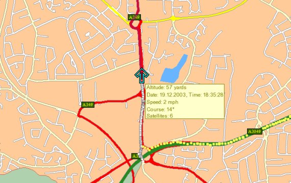
This isn't a major problem though as you do have the facility to change this, and the default was set at 546 yards. You may want to see how quickly InfoMap Navigator re-routes you and adjust this option accordingly to suit your driving skill more.

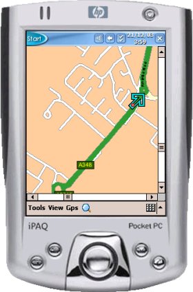
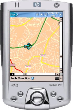
PDA Version The current version of InfoMap Navigator (v1.3.2) provides PDA Support. This allows you to export a highlighted area of the map that you see on the PC to a Pocket PC and to load the Pocket PC version of InfoMap Navigator. I was a little disappointed in the Pocket PC version. Although it claims GPS support, all you can really do is load the map, zoom in and zoom out and see your GPS position on the map. You cannot plot a route on the Pocket PC which was disappointing as I thought this might be a fully fledged Pocket PC Navigation package bundled in with the PC version, but I guess the price is a little low for that.
Problems Experienced and Dislikes
- The first problem I have is that there doesn't appear to be any way of changing the font that's used for the road names. The default font I found on my laptop was far too small and left me having to click on a road to be able to read the road name. For many you may find the road names large enough, but I prefer to have a nice load of roads in view at any one point in time, so having the map zoomed out to 200 yards, I found it impossible to read road names. When set to 100 yards, road names were readable, but still not as large as I would have hoped. I think most of the problem I saw was around small roads, industrial and housing estates. The last thing you really want to do is to start leaning over in the car and grabbing the touch pad on the laptop, or even a mouse or trackball taking your hands off the steering wheel and eyes off the road, which can easily be defined as careless and reckless driving in the UK and driving with undue care and attention, and is liable to a fine and points on your license.
- There is no 3D view, which although isn't essential, it can help in seeing where you are on the road and makes navigation much more easier with other products.
- No POI Search facility to find where the nearest brand of hotel is.
- No support for Road Avoidance, Toll Road Avoidance, or Congestion Zone Avoidance
- Route Re-Calculation option never seemed to re-route me to a new route when I wanted it to, it always seemed to choose the best route and not deviate from this.
- One problem with built-in laptop speakers is that they don't usually have a good amplifier, so you may find with general road noise that plugging in an external speaker will give you better audio.
Price and Availability
InfoMap Navigator can be purchased direct from Directions Ltd or from many GPS Retailers. Now for the prices. If you want the standard versions without the ability to import external databases and implement mapping within your own application then the UK version (including Great Britain and Ireland comes in at £34.99. The Standard European version including 16 countries will cost £49.99. If you want the ability to import databases and implement mapping within your own application then the UK version will cost £99 and the Western Europe version comes in at £129.99. For most, the standard version is more than adequate, and for this £49.99 to include 16 European Countries really is a steal when you compare it to most PDA based systems that cost well over £100 for the software.
Summary
InfoMap Navigator is by far the best PC application we have tested as of the date of this review. It's a very well rounded product, many have chosen to use AutoRoute in the past, but AutoRoute 2002 and 2003 did have problems with how many seconds it would take before your position was updated on-screen and also didn't support proper routing or voice navigation. Looking at InfoMap Navigator and using it in anger, I have found that for the PC, InfoMap Navigator really should be the choice for most. It not only gives you the maps and navigation program at a very affordable price, but it also gives you Navigation, Voice Navigation, Re-Routing, and everything you would expect from a full blown Navigation Product. The only downside with using a laptop in-car is the vibration, and you really need to look at a sturdy laptop mounting system. This will probably mean that your front passenger seat cannot be occupied unless you can find one that brings the laptop across the center console.
|


