|
|
 |
 |
 |
 |
|
Anywhere Map for the Pocket PC |
22nd August 2002
|
|
|

http://www.anywheremap.com
Price
$289.00
|
|
Fly with
tomorrow’s glass cockpit TODAY
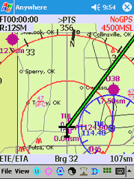
The Anywhere Map™ is a totally unique tool
for today’s pilot, quite unlike anything most pilots have ever used.
Designed and refined by experienced pilots, it combines the important
features of an advanced color moving map, terrain avoidance and flight
management system, flight planner, airport guidebook, flight calculator,
clearance recorder, and copilot, into an amazingly compact and easy to use
package that literally fits into your shirt-pocket. And it
actually costs less than old-fashioned portable color moving maps it
obsoletes. Are you ready for extreme situational awareness?
|
|
|
Compare
these powerful features with systems costing ten times as much:
-
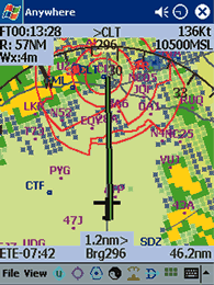
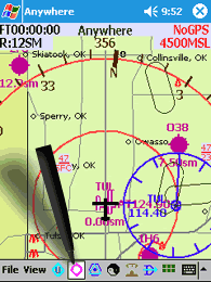
Terrain
elevation and avoidance
-
Obstacle
warnings and avoidance
-
Exclusive
“Cones of Safety” glide prediction system
-
Special
use airspace boundaries, updated daily online
-
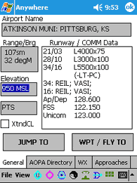
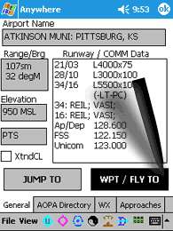
AOPA
airport directory information
-
Published
holding patterns
-
28
day database upgrades with internet convenience.
-
More
than 4000 Instrument approach procedures
-
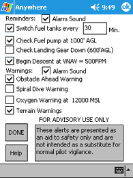
Personal
Digital CoPilot reminders and alerts
-
Nearest
airport, VOR, ATIS, AWOS, FSS and ATC frequencies
-
Vertical
Navigation
-
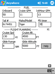
Weight
and balance; Checklists; and flight calculations
-
Optional
in flight weather overlay
"Anywhere
Map is unique in that ALL of these features reside in one beautifully sunlight
readable yoke mountable system. We challenge you to name a single system
that offers all of these features for any price! And you can use the
system outside of the airplane for all sorts of non-aviation uses as well. "
"Our open architecture approach insures that the system will continue to grow,
gaining features and enhancements over time – and our customer friendly
business practices will ensure that no one is ever penalized for buying the
system too soon."
|
Leveling the playing field
When connected to a data-link device such as a satellite phone or an AirCell™
phone, the upgraded AnywhereWX system can deliver NEXRAD weather to the cockpit
-- in flight, in seconds, and even overlay this information on the color moving
map for the ultimate in weather avoidance technology. Now the pilot
of ANY aircraft can have even better awareness of convective activity than most
pilots of sophisticated “glass cockpit” business jets enjoy – all for much
less than rudimentary lightning detection equipment. |
|
|
 |
What are you waiting for?
"Discover what thousands of other pilots already know… Anywhere Map is the most
powerful handheld flight aid ever – the extreme situational awareness it
provides can make you a safer and better pilot. Why not join the
revolution today?"
“The
system is not tested or approved by the FAA or any governmental agency and
should not be used as a primary flight instrument. However, by bringing
together information available from disparate sources, it can increase your
awareness of the “big picture”.
|
|
The FAA calls this “situational
awareness”, but you will call it confidence building, and stress reducing.
Anywhere Map distills position, airspace, terrain, obstacle, and even
weather information down into one easy to interpret display.” |
|
|
 |
 |
 |
 |
|
|