|
|
 |
 |
 |
 |
|
Aeroplane
GPS Navigation |
18th November
2002 |
|
|
Article by Peter Bailey for Pocket GPS
For me,
one of the most fascinating parts of private flying is the process of planning a
route, allowing for wind etc and then actually arriving on time.
VFR
(Visual Flying Rules)
flying, when you can see around you, involves the use of compass and map and
allows the use of navigation aids, beacons etc to verify position and distance.
GPS is
not part of a PPL (Private Pilots License) programme, and in plane GPS equipment is rare in the older club/ hire
aircraft and specialist aviation GPS equipment expensive.
|
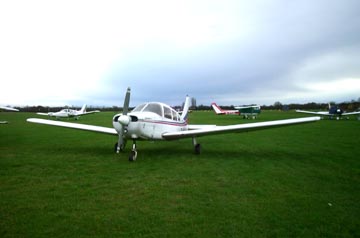
Piper Warrior
|
|
Maps
The
normal procedure would be use a 1/500,000 scale CAA map to plot a course,
measuring distance and direction, and to adjust the various legs according to
wind strength and direction, normally using a so called flight computer. A
destination airport detailed plan is necessary to establish runway directions,
radio frequencies etc and appropriate radio beacons are shown on the CAA maps,
with frequencies.
|
|
Flying with a Pocket PC and GPS
As far
as I am concerned all this has changed considerably since I tried out my Navman
/iPAQ 3850 combination with Memory-Map software and OS and UK road maps. On a
day when VFR flying became practically impossible, due to low cloud cover
increasing, the system gave us added confidence in our conventional instruments
and we managed to return home safely.
Since
then I have been determined to develop a more practical and specialised Airnav
system for our fly aways.
Website
research revealed specialist names such as Navtech, Navsoft, Maptech and
Jeppersen, with programmes and maps specifically for aviators. However,
Memory-Map have just released a set of
UK CAA maps in both 1/250,000 and
1/500,000 scale and include most airport diagrams. I decided to stay with
the devil I knew.
|
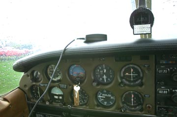
Leadtek GPS Mouse
sitting on the dashboard of the plane
|
|
Very Basic PDA Mount, but it works!
|
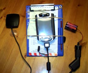
Hardware
The
Navman sleeve does not really allow for a good combination of satellite reception and
screen position so I have opted for an external GPS mouse which can be positioned
on the aircraft windscreen.
Many
light aircraft do not have a cigarette or accessory socket so I have rigged one up
with a simple battery pack. This then allows for an in-car type
setup using a Y lead to connect and power up both the receiver and Pocket PC. It seems
to work well.
Many
pilots use a knee pad strapped to their upper leg to hold check lists,
stopwatch, notes and pencil. I have simply attached 2 strong rubber bands to
this which conveniently keeps the Pocket PC safe and in a good in-flight viewing
position.
|
|
Software
The 1/500,000 CAA maps from
Memory-Map are likely to be most useful and
I have found it of benefit to load smaller scale road maps and airport
plans on the same CF card. With Memory-Map you can simply zoom or
change scales, depending on what you want to do.
For the pre-flight plan, simply use the stylus on a
zoomed out map to mark in the various proposed flight legs. You can
then read off direction and distance in NM.
Get whatever coms and nav data you need from the
map and destination airport plan and make notes. The track / plot
will stay on the map until deleted.
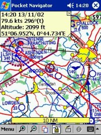
Set up the kit on board, connect the battery, and in a
few seconds the present position will appear as a red circle on the
map. Adjust the zoom level for personal preference, set for moving
map, and you are ready to go.
Once airborne the actual plot and direction is shown as
well as the planned line. This can actually allow you to steer without
looking at the giro compass.
In addition, by getting GPS details a confirmation of
time, direction, speed and height is presented. All of which are
very comforting!
|
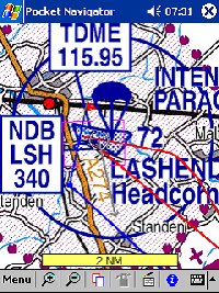
Memory-Map Pocket Navigator
|
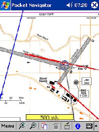
Memory-Map Pocket Navigator
|
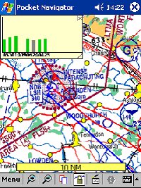
Memory-Map Pocket Navigator
|
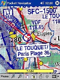
Memory-Map Pocket Navigator
|
|
Battery Source
Due to
most of the older airplanes not having anyway that you can easily
power a Pocket PC or GPS Receiver due to no accessory style socket,
this posed a problem and one that needed to be overcome, so I
firstly created a small battery setup which consisted of a
cigarette/accessory socket, and small stretch of cable connecting
to a battery similar to one out of an alarm box. Connecting the
positive terminal on the battery to the centre of the accessory
socket. The battery itself is a lead acid leak proof battery
which shouldn't give any problems when tossed side to side and
outputs 12v DC which is what a typical car battery will output.
This gives an idea solution if you are either in-car, out on a boat,
or in a plane or helicopter giving you a small and light power
source.
The second
power source I created was using the same accessory style
socket, with a small flex of cable and a 4-way battery socket which
can be purchased from Maplin. This enables 4 NiMh rechargeable
AA Cells which actually makes the setup lighter and better for
flying. |
 |
|
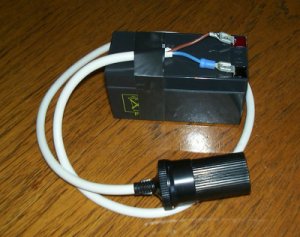
First Power Source Setup Created
|
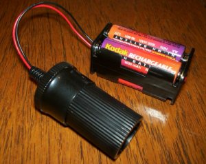
Second Power Source Setup Created
|
|
Conclusion
Whilst not attempting to emulate the so called professional
equipment it is now very possible, at a relatively low cost, to use
your versatile PDA for air navigation. What’s more, it’s lots
of fun!
|
|
|
 |
 |
 |
 |
|
|


