|
|
 |
 |
 |
 |
Tourists follow GPS and end up in the sea
Article by: Darren Griffin
Date: 16 Mar 2012
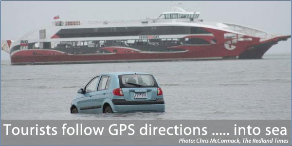
Yet another case of 'engage brain before engaging drive'. This one took place in Queensland, Australia.
Three hapless Japanese tourists decided to drive to North Stradbroke Island. But, rather than take the ferry, they chose to rely on their satnav which guided them out into the sea.
Low tide may have convinced them that there was a drivable route but after 500m they became bogged down in the tidal mud flats and, all too late, realised their error.
They were able to make it back to shore on foot but the car, a rental, was lost. Insurance covered the car but a $1500 excess may make them think before putting so much trust in a satnav instead of their eyes in future.
Source: The Redland Times
| | |  |
| Comments
|
 Posted by matthewj on Fri Mar 16, 2012 10:15 am Posted by matthewj on Fri Mar 16, 2012 10:15 am |
 |
The route seems sensible to me...
http://g.co/maps/tk96a
What's that blue stuff again?
|
|
| Posted by M8TJT on Fri Mar 16, 2012 10:47 am |
|
Shame their sat nav didn't tell them to 'Board the ferry'
|
|
| Posted by spook51 on Fri Mar 16, 2012 1:08 pm |
|
It probably did but omitted to tell them to wait until it berths.
|
|
| Posted by PedroStephano on Fri Mar 16, 2012 9:27 pm |
|
SatNav: "Turn around when possible"
Driver: "I'm trying as hard as I can. It just won't respond. Where's the Alt-F4 keys?"
iOS rokcs (but my typing - well....)
@PedroStephano |
|
| Posted by The Rudd on Sat Mar 17, 2012 6:39 am |
|
Perhaps they were driving to hurry up and catch the ferry ahead in the hope that they could drive on and sail for the rest of the way?
|
|
| Posted by nunga on Tue Mar 27, 2012 2:50 am |
|
This was a crack up for the locals, but truly, if you load brisbane to point lookout (on stradbroke island) into tomtom, it takes you to the ferry terminal at cleavland, plots the ferry course across the bay, and then to the desired destination. Where they launched from was a boat ramp about a km south of the ferry. If that route looked normal to them, what are some of there roads like I alsk ? 
|
|
|
|
 |
|
|
 |
 |
 |
 |
|
|


