|
|
 |
 |
 |
 |
Nokia announce FREE OVI Maps for all
Article by: Mike Barrett
Date: 21 Jan 2010
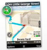 Following on from the announcement at CES Nokia has now formally announced world wide free mapping for both pedestrian and driving modes. This means that from March OVI Maps will be provided pre-installed on the Nokia Navigation phones, and can be downloaded from the Ovi store for existing or other models. Following on from the announcement at CES Nokia has now formally announced world wide free mapping for both pedestrian and driving modes. This means that from March OVI Maps will be provided pre-installed on the Nokia Navigation phones, and can be downloaded from the Ovi store for existing or other models.
The new version of Ovi Maps includes high-end car and pedestrian navigation features, such as turn-by-turn voice guidance for 74 countries, in 46 languages, and traffic information for more than 10 countries, as well as detailed maps for more than 180 countries.
I hear a lot of people cheering and punching the air. This announcement along with Google's free mapping announcements really shakes up the existing navigation market. My first thought was great too, but then I sat down and thought about it:
In today's World nothing comes for free. There is always a catch of one sort or another. I suspect that initially it will be good, it will get a lot more people interested in and using GPS and location aware applications. My concerns are more for the long term of the GPS industry as a whole and us as customers in particular.
Existing business models rely on the navigation company providing a product for a price. Part of this is fed back into product development to add new features or make it more stable. Part of the price goes to 3rd part suppliers to provide up to date maps. Part goes to provide POI datasets etc.
Now if we work on the premise that the application costs nothing then what happens to the companies further down the product supply chain? Well they will probably be forced to cut costs, maybe they will go out of business. Nokia own Navteq, and despite being a separate business unit figures can be adjusted so that the mapping unit still makes 'paper money'. Alternatively the services are paid for by another income stream, but with no income from the navigation business unit the whole business model then becomes a loss leader for another product, or for up-selling premium products.
Ovi maps include traffic so there is little scope there for additional premium products. In this case another revenue stream must be found. This will probably start off with advertising, but mobile advertising has not been very successful to date.
The end result is likely that our Navigation industry becomes a non-profit making side product of a few major global corporations. Current navigation specialist companies will go out of business or be taken over by large corporations. The mapping companies will be run on tighter and tighter budgets, there will probably be cut-backs in services provided, the services may become less accurate, updates could happen with less regularity, etc.
It is clear that this business model is not sustainable. At some point in the future when the corporation (whoever it is) is considering cut-backs the first thing to go is the products that don't make a profit. In this scenario it would be mapping and navigation.
This may all seem like doom and gloom, and I certainly hope it does not materialise, but it is certainly one possible outcome.
Companies like TomTom, Navigon, Magellan and Garmin will find it difficult if not impossible to survive in a world of FREE navigation. Unless they have other product lines like Magellan and Garmin then it is very possible that they will fall by the wayside leaving Nokia, Microsoft and Google dominating, with the future of GPS and Navigation surviving by corporate whim.
So from the euphoric cheers for free navigation applications I am now convinced that GPS/LBS/Navigation should remain something we pay for. Consolidation of our GPS systems into the big corporations I suppose is inevitable, but they should remain profit making business units which will allow them to prosper.
| Comments
|
 Posted by MikeB on Thu Jan 21, 2010 11:01 pm Posted by MikeB on Thu Jan 21, 2010 11:01 pm |
 |
The following is the official Nokia Press Release:
Nokia makes walk and drive navigation free on its smartphones, doubling size of mobile navigation market
January 21, 2010
Espoo, Finland - Nokia has today announced plans to release a new version of Ovi Maps for its smartphones that includes high-end walk and drive navigation at no extra cost, available for download at www.nokia.com/maps. This move has the potential to nearly double the size of the current mobile navigation market.The new version of Ovi Maps includes high-end car and pedestrian navigation features, such as turn-by-turn voice guidance for 74 countries, in 46 languages, and traffic information for more than 10 countries, as well as detailed maps for more than 180 countries.
"Why have multiple devices that work that work in only one country or region? Put it all together, make it free, make it global and you almost double the potential size of the mobile navigation market ," explained Anssi Vanjoki, Executive Vice President, Nokia. "Nokia is the only company with a mobile navigation service for both drivers and pedestrians that works across the world. Unlike the legacy car navigation manufacturers, we don't make you buy maps for different countries or regions even if you're only visiting for a few days. We offer both navigation and maps free of charge, with all the high-end functionality and features that people now expect."
"The large-scale availability of free-of-charge mobile phone navigation offerings using high-quality map data will be a game changer for the navigation industry," said Thilo Koslowski, Vice President Automotive and Vehicle ICT at Gartner. "Such offerings will accelerate mass market adoption for navigation solutions and shift innovation focus to location-based services that go beyond traditional routing benefits."
For Nokia, removing the costs associated with navigation for drivers and pedestrians allows the company to quickly activate a massive user base to which it can offer new location features, content and services. This is part of Nokia's strategy to lead the market in mobile maps, navigation and location-based services. The move is also in line with Nokia's vision that the next wave of growth will be centered onthe location-aware, social internet -- as the 'where' people are doing things becomes as important as the 'what' they are doing.
According to research firm Canalys, the number of people worldwide using GPS navigation on their mobile phones was approximately 27 million at the end of 2009. With this announcement Nokia potentially grows the size of this installed user base to about 50 million by enabling smartphone owners, with compatible devices and devices that will be made compatible shortly to activate free drive and walk navigationthrough a simple download of the new Ovi Maps. Nokia will further grow this base as it quickly adds more smartphones to the compatible devices list. Canalys also estimated in 2009 that the installed base of smartphones with integrated GPS was 163 million units worldwide, of which Nokia accounted for more than half (51%) having shipped cumulatively 83 million GPS devices.
"This is a game changing move. By leveraging our NAVTEQ acquisition, and our context sensitive service offering, we can now put a complete navigation system in the palm of your hand, wherever in the world you are, whenever you need it - and at no extra cost," continued Anssi Vanjoki. "By adding cameras at no extra cost to our phones we quickly became the biggest camera manufacturer in the world. The aim of the new Ovi Maps is to enable us to do the same for navigation."
By removing the added costs for consumers Nokia expects to fuel the take-up of mobile maps and navigation providing its ecosystem of partners with clear business opportunities:
- For operators:
Nokia believes it will enable them to offer their customers a complete car and personal navigation package as well as encourage the take-up of data plans. An additional benefit for operators is that Ovi Maps uses a unique hybrid technology that is optimized for use on a mobile network. By using advanced vector graphics, plus an intelligent combination of pre-loaded and online maps, the new version of Ovi Maps uses a fraction of the bandwidth of the bulky bitmap technology used by most mobile map providers.
- For 3rd party application developers:
Making navigation on a mobile as familiar as sending a text or taking a picture presents a huge opportunity as the customer base for additional location-based applications expands. Via the Ovi for Developers Beta Program, Nokia has given selected developers and publishers a preview of the Ovi APIs and SDK - Beta (software development kit) which will allow them to build such applications. These will then be made available through Ovi Store by Nokia.
Ovi Maps is immediately available for download for 10 Nokia handsets, including the popular Nokia N97 mini, Nokia 5800 XpressMusic and Nokia E72, with more Nokia smartphones expected to be added in the coming weeks. In the meantime, current owners of Nokia smartphones that are compatible with the new Ovi Maps can download it free of charge from www.nokia.com/maps.
From March 2010, new Nokia GPS-enabled smartphones will include the new version of Ovi Maps, pre-loaded with local country map data, with high-end walk and drive navigation and access to Lonely Planet and Michelin travel guides at no extra cost.
Ovi Maps covers more than 180 countries with car and pedestrian navigation for 74 countries in 46 languages and 6000 3D landmarks for 200 cities around the world. Lonely Planet and Michelin guides have information on more than 1,000 destinations globally.
Mike Barrett |
|
| Posted by vicz on Fri Jan 22, 2010 8:46 am |
|
Unfortunately I suspect that "shift innovation focus to location-based services that go beyond traditional routing benefits" will be mainly targeted advertising, journey monitoring, speed control, and other government-driven repressive features.
Nuvi 360T, GTM12 |
|
| Posted by Simon1 on Fri Jan 22, 2010 9:00 am |
|
Do you know if this Nokia system also allows full UK postcode searches?
|
|
| Posted by golf747 on Fri Jan 22, 2010 9:33 am |
|
Tried updating phones software but would only update to 30.0.011.......nokia syas you need version 31 or above, so how to get that version? Any ideas?
|
|
| Posted by stefanoza on Fri Jan 22, 2010 11:46 am |
|
The maps may be free but you have use the service to download them - this is not free! and I'm guessing that maps will be frequently updated in the background to give the phone folk a nice little stream of income.
I have a Nokia N97 with Ovi maps and it sort of works but the user interface is really crap, it does do address search and navigation but I can't be bothered to spend the time trying to figure it out, it doesn't help that there is no manual....
|
|
| Posted by CryHavok on Fri Jan 22, 2010 1:04 pm |
|
stefanoza, I don't know where you get your information from but downloading the maps is only not free in regards to data charges, if you don't simply hook the phone up to a computer and download them over your Internet connection. Unless your phone is your only Internet connection there's no reason for map updates not to be free.
|
|
| Posted by pcaouolte on Fri Jan 22, 2010 1:10 pm |
|
Does the PGPSWorld speed camera database work with Nokia OVI maps?
Paul |
|
| Posted by ala_fred on Fri Jan 22, 2010 1:49 pm |
|
| Simon1 Wrote: | | Do you know if this Nokia system also allows full UK postcode searches? |
yes it will work with full uk post code

edited to clarify PaulB2005
|
|
| Posted by flyingfuzz on Fri Jan 22, 2010 2:22 pm |
|
Whatever we think about navigating on a mobile phone it is the way the market will shift.
We have seen this with PDA’s, MP3’s, cameras and to an extent pagers. The marketing always was “why carry several items when you can carry one” The smart phone will become the only item carried by the majority of people. Sure there will be people who want a stand alone product like a camera. But just go and see how many teenagers carry a camera today, most use their phone.
The majority of satnav users only want to go from point A to point B and are not interested in the “other” bells and whistles. so a simple product on a phone is ideal.
With the smart phone market trying to entice users away from the IPhone free satnav is a good marketing ploy.
TT520 running App 8.351 & map UK&I v845.26345
Using Traffic TMC (round pin) & PGPS speed cameras. |
|
| Posted by PedroStephano on Fri Jan 22, 2010 4:39 pm |
|
I for one will be applying regular does of TLC to my TomTom Go300 to make it last for ever. My iPhone on Google maps provides good journey overview, traffic and maps, including the more-interesting aerial view; but TomTom traffic is much better for A-roads, and if you get a phonecall the map goes off! Thereby rendering the device useless until the call is over - a nightmare in London for example. I work on the road (and being a bloke can easily multi-task), so refer to the TomTom (voiceless mode) for SatNav whilst iPhone does the calls - or music - or DAB radio - or whatever. Even the integrated SatNav on my new Audi A4 turns off when a phonecall comes in.
For some of the market - myself included - a separate PND is the ultimate solution.
iOS rokcs (but my typing - well....)
@PedroStephano |
|
| Posted by Madcaravanner on Fri Jan 22, 2010 5:22 pm |
|
So everyone is going on about Nokia Maps
Has ANYONE else tried using them outside of European mainland ????
Malta is Rubbish
Cyprus is Rubbish
Egypt is rubbish
I will be happy when they get the coverage sorted down to decent street level not just major major roads
Regards
Gray
the Madcaravanner
gray@madcaravanner.co.uk
http://www.madcaravanner.co.uk |
|
|
| Click here to view more comments... |
|
 |
|
|
 |
 |
 |
 |
|
|


