Hi! We see you’re using an ad-blocker. We’re fine with that and won’t stop you visiting the site.
But as we’re losing ad-revenue from this then why not make a donation towards website running costs?. Or you could disable your ad-blocker for this site. We think you’ll find our adverts are not overbearing!
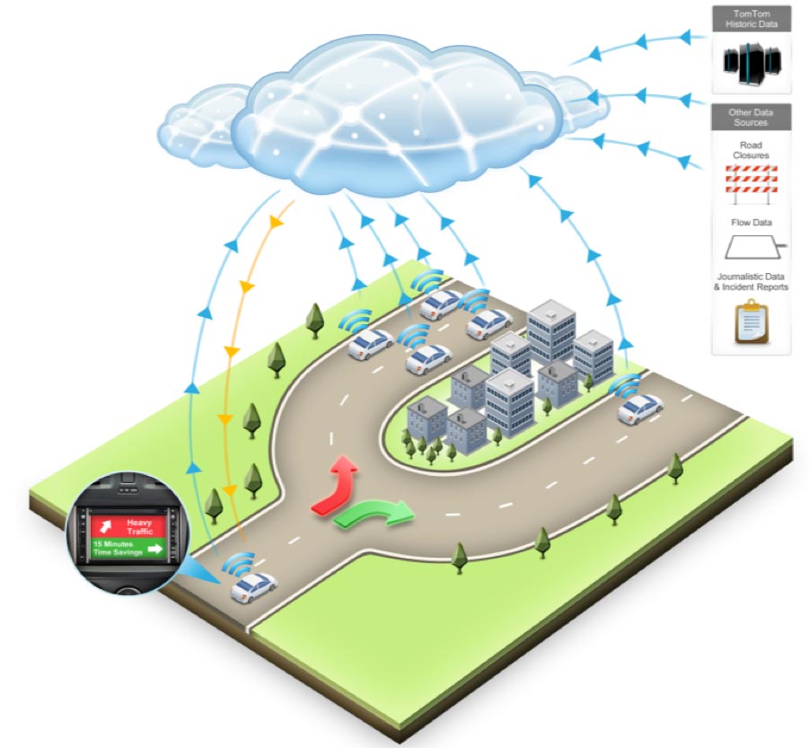
The final piece of the puzzle in the making of TomTom's maps is the dynamic attributes assigned to each road segment. By this I mean the real-time traffic information. Back in 2008 TomTom announced the then all new GO 940 Live SatNav. This had their latest innovation real-time live traffic known as HD Traffic. This fourth article in the series of How TomTom Make Digital Maps looks at how this traffic information is collected and distributed to the SatNav devices.
In the previous articles we have seen how the geometry of the map is created, then the attributes for each road segment have been added. With IQ Routes each road segment was assigned a 'real speed' based on historic average speeds in 5 minute intervals. Now with HD Traffic we can see how these IQ Route average speeds can be dynamically updated in near real time with actual current road speeds.
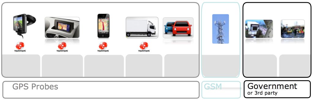
Winding back to 2008 TomTom wanted to introduce a more accurate method to collect and transmit traffic information. At the time the only traffic was collected by a few agencies that used either traffic sensors on the major road networks or what are known as 'probes' which were mainly devices in commercial vehicles reporting the road speeds. This information was combined with editorial data and transmitted to the SatNav alongside the radio signals using a technology called RDS-TMC. Editorial data is information from a traffic centre where incidents are reported and recorded. Typically in the UK this would be the Highways Agency. These are the normally the messages that you would see on the roadside signs.
For the early days this was great, assuming that the signal was strong enough and the data could be received. However it was not long before the users demanded (or at least expected) better and more accurate traffic information indicating the impact on their journeys. This was not possible to achieve with the existing infrastructure so TomTom decided to look at using more community input.
Now for real time traffic information that is reliable it is not really possible to ask users to report incidents, or assess road conditions. Apart from the obvious fact that users, no matter how conscientious, would get it wrong. It would be highly likely that issues would not get reported in the first place, nor cleared when the traffic flow is back to normal. The only way to tell how traffic is moving is with live probe data, also known as floating car data.
This of course generates a chicken and egg situation. You cannot get floating car data without devices that can provide the data, but nobody is going to buy a device that provides this data if they don't get any benefit. So the TomTom boffins put their thinking caps on and thought about online devices that could be monitored to determine what speed they were travelling at. The answer was mobile phones.
Mobile phones cannot be traced when they are not making active calls, but when users are making calls they can be located by cell towers, in particular when passing calls between cell towers. It was also determined that whenever there was a traffic incident people would be more likely to call to let someone know that they would be late. This technology seemed to be the ideal solution to the traffic data collection issue. TomTom entered into an arrangement with Vodafone to provide anonymous information on the movement of phones. This provided the backbone of the HD Traffic service.
Our video shows Carlo van de Weijer explaining the concepts of HD Traffic giving some live examples of HD Traffic routing during the Paris rush hour.
Knowing how mobile phones are moving is not quite the same as knowing how the traffic is flowing and there are a number of instances where this technology just will not work. Consider a busy city centre. There will be lots of people walking around whilst talking on their phones. This would look like the traffic is flowing at about 2 MPH with the occasional one or two moving at 20 MPH. Another issue was quite a head scratcher for the boffins at TomTom. On a busy road with traffic flow at 30 MPH all of a sudden the flow increased to 80 MPH, faster than the speed limit, then slowed down again. It turned out that there was a train track with the road running alongsidethe tracks and every the a train went through they registered the people talking on phones on the train.
Having overcome some of the anomalies TomTom now had the core of the improved traffic data and were able to introduce this into the mix for the information they provide to the SatNav users. This when consolidated with the other traffic information sources the data feed is sent to the SatNav as HD Traffic. This then provided the platform for TomTom to launch the first GO LIVE product, the TomTom GO 940 LIVE, towards the end of 2008.
The GO LIVE introduced a SatNav which had a built in SIM card to transfer data between the device and TomTom's servers in real time. The navigation app was already very closely linked to the then Tele Atlas maps, and likewise TomTom's MapShare, and IQ Route technologies so it was not a big leap for the SatNav to start sending speed information related to the road segments in real time. TomTom were now able to build their own network of live probes providing direct feedback to the central servers to be distributed over the entire TomTom live device network.
Having built and populated the infrastructure for HD Traffic TomTom now started to build up the number of LIVE devices that they have in the field. Each device acts as a data probe sending back precise information over the entire road network, not just the major routes. More and more LIVE devices were added to the range meaning more and more data probes were out on the roads providing live feedback about traffic conditions. Today the TomTom range consists of six core hardware devices, a third of which are LIVE devices. TomTom HD Traffic is available on the iPhone App as well meaning that each user of the App is now part of the community of floating car probes extending TomTom's coverage of the road network.
As the number of users of LIVE devices built up so did the resolution of the traffic information that was fed back to TomTom. This resulted in a change of emphasis over the years away from the mobile phone data towards the TomTom LIVE device data as the primary source for the traffic information. The information is so accurate that it can determine to a minute how long the delays are on your trip.
Of course knowing the delay in your arrival time is good, but the information is far more useful than that. As I mentioned earlier each road segment has a 'real speed' associated with it using IQ Routes. With the traffic information these real speeds are replaced with the actual speed on the road now. This means that when calculating the route the routing engine no longer relies on statistical averages, but uses actual speeds. This intelligence allows your TomTom to either avoid traffic altogether or to provide you with an accurate arrival time.
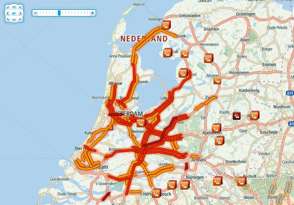
This really came to the fore in February this year when Amsterdam was hit be a freak snow storm that really only affected Amsterdam and not the rest of Holland. The TomTom HD Traffic accurately recorded the events and showed all the traffic jams in and around the city, all the way down to the narrow streets which showed no traffic as they would normally be very slow anyway. Most of the locations that were showing slow traffic on the TomTom HD Traffic displays were only available to TomTom HD Traffic clients as no other agency had the ability to collect traffic data to this granuality.
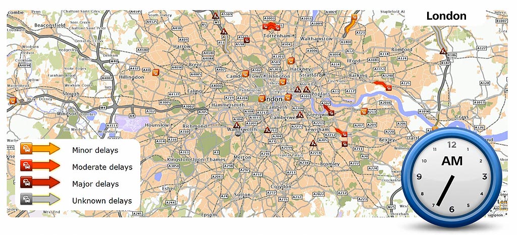
This traffic data is available to view free of charge on TomTom's website at http://www.tomtom.com/livetraffic/. Here you can see the live state of the road networks according to the TomTom HD Traffic service.
This all sounds great, but things are not quite as simple as that, they never are are they? If you are planning a long trip say of a three hour duration then the further away from the current location you travel the less relevant the actual sped of the road isto you now. For instance if I set off from home in Essex at 15:00 heading up the M1 to the Lake District the actual speed of the M6 around Birmingham could be 60MPH. However as Birmingham is about 100 miles away I will not get there until after 17:00 at which time the traffic speed is likely to be 25MPH so a live speed of 60MPH is meaningless.
This effect is known as the Traffic Horizon. TomTom have determined that on average major delays are cleared within 40 minutes and have thus set the traffic horizon to that distance. A recent change from a higher value sparked a flurry of complaints from users as this moved the traffic horizon across a critical boundary for some trips. What this means in reality is that a major incident on the M25 may not be included in the routing calculations and you could be blissfully ignorant of problems until you have committed to the route. If the Traffic Horizon had been further out the incident would register and the routing could have taken you the other way round the motorway.
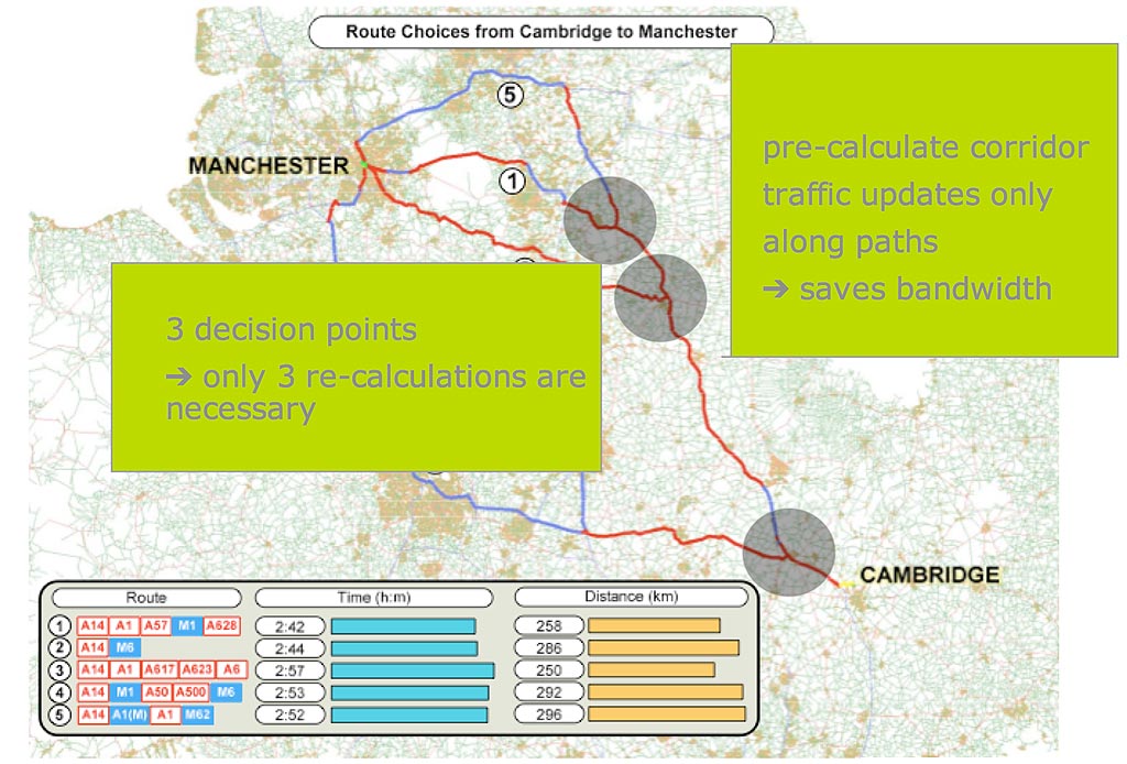
As TomTom now know the current speeds of the road network the system constantly scans the possible routes looking for a faster way to get to your destination. This is known as dynamic routing. Dynamic routing doesn't examine the complete routing options as a route calculation would, but it does look at a number of alternative routing corridors between your current location and your destination. If the traffic conditions change then the Dynamic Routing will re-calculate your arrival time, and also try and find a faster route to your destination.
We have now seen how all the components come together to make the maps and then add value to them to make them more useful to us when driving. Our next and final article in the series looks at how TomTom make changes to the maps using a practical example.
Posted by dorsetwurzel on Thu Aug 23, 2012 4:41 pm
Very interesting article. Looking forward to the next one.
Posted by jonrome on Fri Aug 24, 2012 8:21 am
It would be great if someone could produce a way to convert present day maps to th run on the thousands of Alpine systems installed by Jaguar up to the the late 2000s. Absolutely no support.
A disgraceful state of affairs for a company like Jaguar who appear to be proud of their heritage but really only want to sell you a new car.
Posted by Surfing_spider on Fri Aug 24, 2012 9:35 am
Great Article. I really like getting to know the details of exactly how these systems work.
What I really want to know is why the junction priorities are wrong so often. i.e. when you are driving along a road and it tells you to take a left turn but this is just a natural continuation of the road. There does not seam to be a part of mapshare that allows you to correct this. I am eager to help fix these issues but can't.
Posted by Daggers on Fri Aug 24, 2012 9:52 am
Surfing_spider Wrote:
What I really want to know is why the junction priorities are wrong so often. i.e. when you are driving along a road and it tells you to take a left turn but this is just a natural continuation of the road. There does not seam to be a part of mapshare that allows you to correct this. I am eager to help fix these issues but can't.
I'm with you on this one - you can just about work it out if it tells you to turn left when the only obvious straight-on route takes you up a farm track, but if you're in a built up area and told "in 400 yards, take the 3rd left" it gets a whole lot more confusing.
Garmin DriveSmart 50 LMT-D
Posted by cbrown7 on Fri Aug 24, 2012 2:05 pm
I'm with Surfing_spider and Daggers on this one. Plus, why on UK back (B) roads do Tom Tom's often not alert you at all to cross roads you have to give way at? I know it is up to the driver to interpret the road and drive to the conditions etc. but you do tend to get lulled into a false sense of security if you have no warnings of impending actions.
I can't believe this is down to priority changes as most of these roads have been there for years, with little traffic, so why would they change?
Great article by the way.
Posted by pillboxman on Fri Aug 24, 2012 2:52 pm
Great article. Thanks.
My guess would be that the 8/10 meter 'spots' on the roads is the reason that the on screen mapping is so much better on a TT than a Garmin.
As well as speed cameras I use my TT to help me drive more economically. I can see the road ahead and slow down or speed up depending on the bends in the road. This saves tire wear, fuel and brake pads!
Oh, and it's great at navigating as well.
Posted by MikeB on Fri Aug 24, 2012 4:44 pm
pillboxman Wrote:
... My guess would be that the 8/10 meter 'spots' on the roads is the reason that the on screen mapping is so much better on a TT than a Garmin. ...
The 8 or 10 metre bits only refer to the imaging so a picture is taken and geo-referenced at those intervals.
Typically there will be far less points in the map as they are simply not required. A road is normally pretty straight for long distances so additional points are only required at junctions.
Mike Barrett
Posted by Stormtracker on Fri Aug 24, 2012 5:58 pm
If TomTom go out-and-about in their "car derived van" doing some of the mapping, then surely they can create a section in the menu for vehicle types: Such as-
Are you driving a Car, Large Goods Vehicle etc. So it can route narrow or wide roads only.
Because I am sick and tired of approaching an "Unnamed Road", or "B" road slowing down and thinking, yes this is wide enough for me and another vehicle to pass without problems. To get half way down this road, to find that it narrows alot and that my Large Goods Vehicle is actually wider than the road and I am stuck facing an oncoming vehicle - obviously using a TomTom too.
and another thing - "Turn-a-round when possible". lmao, you try turning round a 7.5tonne flatbed truck on an urban road.
Sometimes, I just want to put my "TT820go live" under the front wheels and say Route This.
Excellent article by the way. However, if TomTom use all this technology, why are their maps still upto 1 year out of date?
Posted by pillboxman on Fri Aug 24, 2012 6:26 pm
Stormtracker Wrote:
If TomTom go out-and-about in their "car derived van" doing some of the mapping, then surely they can create a section in the menu for vehicle types: Such as-
Are you driving a Car, Large Goods Vehicle etc. So it can route narrow or wide roads only.
Because I am sick and tired of approaching an "Unnamed Road", or "B" road slowing down and thinking, yes this is wide enough for me and another vehicle to pass without problems. To get half way down this road, to find that it narrows alot and that my Large Goods Vehicle is actually wider than the road and I am stuck facing an oncoming vehicle - obviously using a TomTom too.
and another thing - "Turn-a-round when possible". lmao, you try turning round a 7.5tonne flatbed truck on an urban road.
Sometimes, I just want to put my "TT820go live" under the front wheels and say Route This.
Excellent article by the way. However, if TomTom use all this technology, why are their maps still upto 1 year out of date?
Have you considered purchasing one of the HGV PNV's? You can put it against your tax.
Posted by DennisN on Fri Aug 24, 2012 9:51 pm
cbrown7 Wrote:
I'm with Surfing_spider and Daggers on this one.
[snip]
I can't believe this is down to priority changes as most of these roads have been there for years, with little traffic, so why would they change?
Great article by the way.
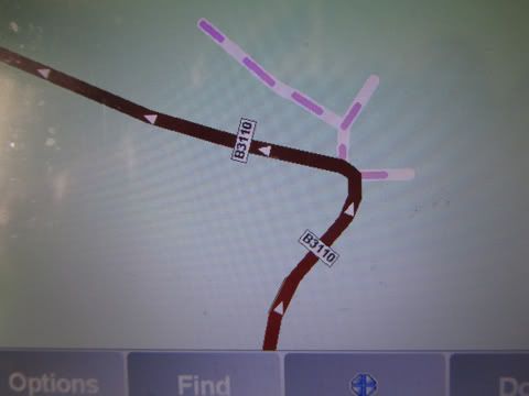
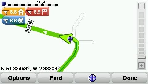
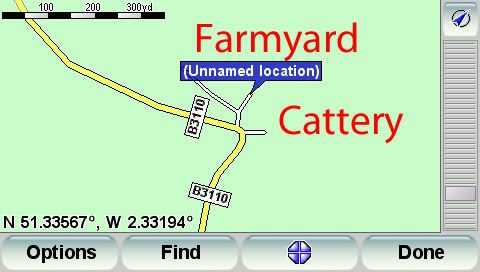
The reason for all these funny instructions is TomTom have reduced the details on some "roads", presumably for space constraints on mapping. Compare these two screendumps taken from two devices, running side by side, but with different map versions - the first one is an older map, second a more recent one.
Now for side roads.. Here are two views of the same spot. The first picture is from my ancient map (2006-ish?), the second and third are from the current map which instructs me to turn left or right at this corner. Notice that in the older map, the offshoot "roads" used to have the purple dots which denote non-navigable roads. I regularly get exactly the same from laybys - instructed to keep right (and not go into the layby). No doubt the savings allow TomTom to add value, like facebook and twitter links! And avoid the need to increase the size of the device's internal storage. A few months ago, in North Devon, I was instructed to turn right when the straight ahead alternative was over a stile and along a green lane filled with weeds four feet high!
Dennis
If it tastes good - it's fattening.
Two of them are obesiting!!
Posted by Stormtracker on Fri Aug 24, 2012 11:37 pm
[quote=“pillboxman”]Have you considered purchasing one of the HGV PNV's? You can put it against your tax.[/quote]
Hi Pillboxman,
I only bought this TT820 back in April this year, as I was using it mainly for my car and occasional driving when one of the drivers was on-leave/off-sick at work but in the past couple of months, I am now one of the permanent drivers and I have found how useful my TT really is. TT's PNV's are only good for Car Navigation and (expletive) for Truck use.
Yes, I have been looking at a Snooper Truckmate and I may have to purchase one of these before I lose my insanity or drive over my TT - which ever comes first .
Hi! We see you’re using an ad-blocker. We’re fine with that and won’t stop you visiting the site.
But as we’re losing ad-revenue from this then why not make a donation towards website running costs?. Or you could disable your ad-blocker for this site. We think you’ll find our adverts are not overbearing!