| View previous topic :: View next topic |
| Author |
Message |
mikealder
Pocket GPS Moderator


Joined: Jan 14, 2005
Posts: 19638
Location: Blackpool , Lancs
|
 Posted: Mon Apr 09, 2007 7:18 pm Post subject: GPS Position with Artemis Camera Posted: Mon Apr 09, 2007 7:18 pm Post subject: GPS Position with Artemis Camera |
 |
|
HTC are not renowned for the quality of the cameras fitted to their devices, the Artemis is no exception to this. What is useful though is to embed the GPS Lat/ Long into the picture. Here is how to achieve this, the Geo tagging of a photo is actually built in to the Artemis and its derivatives. The T-Mobile Compact III and the O2 XDA Orbit can all achieve this functionality with a simple tweak, it is one of the features the manufacturers disabled!
Please read through all of the instructions before deciding this is worth trying!
First of all you will need a registry editor program, I use PHM Reg Edit and/ or Kilmist Reg Edit but any will suffice.
Start the Reg Edit program and go to :-
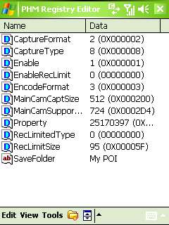
My Device/ HKEY_LOCAL_MACHINE/ SOFTWARE/ HTC/ Camera/ P9 and your screen will look like:

Tap the Enable line and change the value from 0 to 1
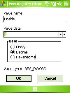
then click OK
Exit the registry edit program then press and hold the Power On/ Off switch, when prompted Do you want to continue answer yes, this saves the data.
Using the reset switch is unreliable and doesnt always save the modified settings. Switch on the unit and allow it to boot up.
Select the camera function, then change the mode with the selector top right, you are looking for this screen:

Note you will need to be outside as the camera needs a GPS fix in order to function when using this mode.
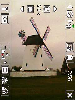
(Note the new icon showing GPS fix in green upper right). With a GPS fix the camera functions as normal, so go and take some pictures with the device in GPS mode.
Once you have done the above your GPS tagged pictures can be found in the My Device/ StorageCard/ MyDocuments/ MyPOI folder.
Viewing the additional information
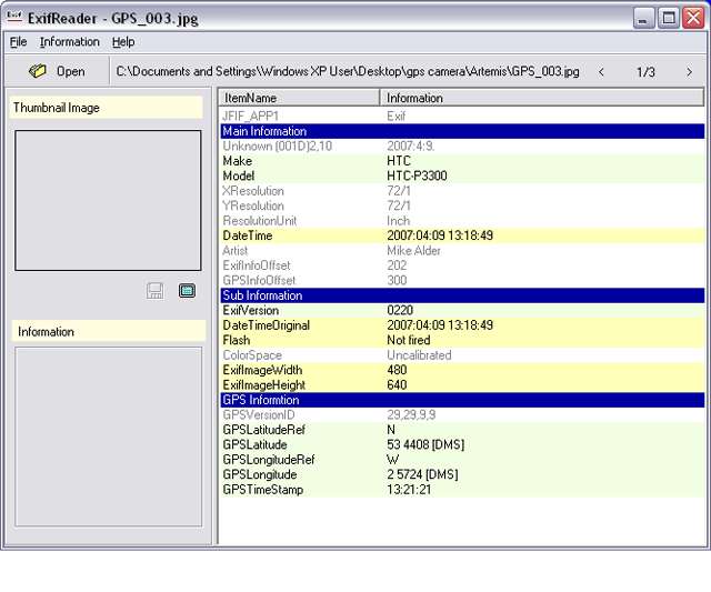
If all you want is to extract the Lat/ Long you can use a reader to view the embedded information. Exif is one of many programs designed to do this, and its free. When you open a picture you can either display the image or view the information
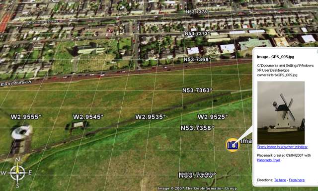
Another (and better method) is to use Panorado Flyer which interfaces with Google Earth, once installed use Windows Explorer to locate your photo files on the PC, right click a picture and select Pandorado Flyer/ Show location in Google earth from the pop-up. This action automatically launches Google Earth and displays the picture on the satellite photograph where it was taken.
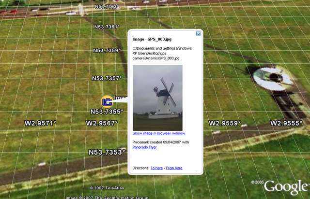
Now for the bad news, the above works fine with the HTC Artemis P3300 but when I tried it on the T-Mobile C-III the lat/ long seconds value were the same, this results in a positional error. In the Lytham Windmill photo the error was 305 Meters.
MikeB reported similar findings earlier with the XDA-Orbit, why the Artemis works and the others dont is a mystery at the moment, unless anyone has any suggestions?
WARNING MESSING AROUND WITH THE REGISTRY CAN CAUSE YOUR DEVICE TO BECOME UNSTABLE, PLEASE DONT BE TEMPTED TO PLAY UNLESS YOU ARE CONFIDENT OF WHAT YOU ARE DOING. |
|
| Back to top |
|
 |
tchart
Regular Visitor

Joined: Apr 06, 2005
Posts: 121
Location: Wellington, New Zealand
|
| Posted: Wed Apr 11, 2007 9:56 pm Post subject: |
|
|
Hey Mike,
Nice write up! I like the csreen shot of GPS Speed Sentry in action 
I really like the fact that you can create geo-tagged images with the camera.
In terms of professional GIS software ESRI's ArcMap and ArcPad applications can read images with location tags (they call them photo layers).
Its interesting that this is catching on in the consumer arena, up until recently I was only aware of a few high end GPS devices that would do this or some digital cameras that have GPS modules (eg Canon).
Regards
Trevor
_________________
Tchart Development
www.tchartdev.com |
|
| Back to top |
|
|
weelogic
Regular Visitor

Joined: Oct 18, 2004
Posts: 111
Location: South of Glasgow, West of Scotland
|
| Posted: Sat Sep 29, 2007 9:43 am Post subject: |
|
|
| I just thought I would let you know that, after running the official O2 update to Windows Mobile 6, the accuracy of the geotagging function on the XDA Orbit is vastly improved. I have tried a couple of test shots and it is correct within 10 metres, which for most situations is enough. Maybe a geotagged photo should accompany camera submissions... :-) |
|
| Back to top |
|
|
FrequentFlyer
Lifetime Member

Joined: Jun 12, 2006
Posts: 962
Location: London
|
| Posted: Wed Nov 07, 2007 8:58 pm Post subject: |
|
|
| Mike. I thought that I have been happily taking photo's, but when I come to look in My Documents/My POI....zero ! Any ideas please ? |
|
| Back to top |
|
|
mikealder
Pocket GPS Moderator
Joined: Jan 14, 2005
Posts: 19638
Location: Blackpool , Lancs
|
| Posted: Wed Nov 07, 2007 9:07 pm Post subject: |
|
|
| Have a look on the storage card and see if its put the pictures on that instead, what settings for storage have you got set when you start the camera application on the phone, and which model/ OS are you using - Mike |
|
| Back to top |
|
|
FrequentFlyer
Lifetime Member
Joined: Jun 12, 2006
Posts: 962
Location: London
|
| Posted: Wed Nov 14, 2007 9:44 am Post subject: |
|
|
| It's the new Vario 111 .... found a couple of pictures under POI as you stated, (having taken them again.) The GPS green light was definately 'on' when I took them, but, and another daft one perhaps, but where do I see/find the lat/long of each picture ? |
|
| Back to top |
|
|
mikealder
Pocket GPS Moderator
Joined: Jan 14, 2005
Posts: 19638
Location: Blackpool , Lancs
|
| Posted: Wed Nov 14, 2007 6:30 pm Post subject: |
|
|
| Follow the links in the guide above to find Exif and/ or the Pandoro Flyer application which can display the additional GPS information or in the case of the latter software it will put your picture on the Google Earth map on the PC (assuming you have Google Earth installled) - Mike |
|
| Back to top |
|
|
weekub
Occasional Visitor
Joined: Nov 29, 2007
Posts: 1
|
| Posted: Thu Nov 29, 2007 10:55 am Post subject: |
|
|
| Is it possible to use with External GPS device. Cos, I'm using HTC Touch (Elf). Thanks |
|
| Back to top |
|
|
mikealder
Pocket GPS Moderator
Joined: Jan 14, 2005
Posts: 19638
Location: Blackpool , Lancs
|
| Posted: Sat Dec 01, 2007 10:05 am Post subject: |
|
|
| As this method starts up the internal GPS and uses that by default, I doubt it would be possible to use an external GPS to supply the positional data. You could always try it, but I very much doubt this will work on the hardware you are using - Mike |
|
| Back to top |
|
|
Sterndl
Occasional Visitor
Joined: Jun 28, 2008
Posts: 4
|
| Posted: Sat Jun 28, 2008 8:39 pm Post subject: It doesn't work |
|
|
Hello Mike,
I found your tip and it looked great!!!
I tried it out on my T-Mobile compact III.
It stores the coordinates in the picture, but the problem is, it doesn't initialize the internal GPS, so the coordinates are 0,00000/0,00000
So I tried it with a running navigation-application, but nother.
Hav you any idea??
thx for help
 Sterndl Sterndl |
|
| Back to top |
|
|
mikealder
Pocket GPS Moderator
Joined: Jan 14, 2005
Posts: 19638
Location: Blackpool , Lancs
|
| Posted: Sat Jun 28, 2008 8:42 pm Post subject: |
|
|
| I have used this method on the Artemis and the Compact III and it works (to a certain extent), if, however you are running WM6 on the unit then it doesn't work - perhaps this is the issue? - Mike |
|
| Back to top |
|
|
Sterndl
Occasional Visitor
Joined: Jun 28, 2008
Posts: 4
|
| Posted: Sat Jun 28, 2008 8:51 pm Post subject: |
|
|
That's right, I'm using WM6 on my unit.
Are there any ways to get this feature on my phone with WM6?
Or do you know a third party applikation, that writes the GPS infos into the picture?
on symbian I have an application named "location tagger" that runs in the background and tags the picture after it is taken. |
|
| Back to top |
|
|
mikealder
Pocket GPS Moderator
Joined: Jan 14, 2005
Posts: 19638
Location: Blackpool , Lancs
|
| Posted: Sat Jun 28, 2008 9:54 pm Post subject: |
|
|
My O2 Orbit II can be made to use the GPS Photo mode and that is running WM6 but the reg edit that was required was a little more than the one used for this.
Since I got the Orbit - II working I have never tried the same reg edit on the C-III or Artemis with WM6 installed, I will dig out the information and try it (it is posted on this site somewhere IIRC), whether it works or not on the C-III I will reply with some information on this idea in the morning - Mike |
|
| Back to top |
|
|
Sterndl
Occasional Visitor
Joined: Jun 28, 2008
Posts: 4
|
| Posted: Sat Jun 28, 2008 10:31 pm Post subject: |
|
|
You're GREAT, thx!
I've tried out a little bit more.
Now I think it could be a problem with the com port.
Because the Navi and tracking SW I use can set the right com port (COM4) in the options. and anything works fine.
Now I tried the free SW "locr" and there is the same problem that it could not connect to gps. in this sw you can not set the port of the gps, it says always "waiting for the first fix" and nothing more happens.
with navi and tracker I have a fix in a few seconds.
otherwise the camera application is no third party app and so I think it should know on wich com port the gps is running.
maybe this could be a hint.
Sterndl
 |
|
| Back to top |
|
|
mikealder
Pocket GPS Moderator
Joined: Jan 14, 2005
Posts: 19638
Location: Blackpool , Lancs
|
| Posted: Sun Jun 29, 2008 12:23 pm Post subject: |
|
|
Having had a good mess around with this I have got no where other than having to hard reset the C-III which is no problem as there was nothing on it that cannot be put back.
The nearest I have got is when selecting GPS Photo mode it pops a warning up "Cannot initialize the GPS service" when you press "Done" it reverts back to the standard camera mode.
It will only display this message if you start the camera application with it selected to internal memory, if you start the application in Storage card mode it does indeed take pictures with the lat/ long set to zero and the GPS hardware is not being started by the application.
I cannot see any other reg settings that could get this working, perhaps it is the Camera application software that has disabled this mode - Mike |
|
| Back to top |
|
|
|
![]() Posted: Today Post subject: Pocket GPS Advertising Posted: Today Post subject: Pocket GPS Advertising |
|
|
We see you’re using an ad-blocker. We’re fine with that and won’t stop you visiting the site.
Have you considered making a donation towards website running costs?. Or you could disable your ad-blocker for this site. We think you’ll find our adverts are not overbearing!
|
|
| Back to top |
|
|
|


