|
Article by
Dave Burrows
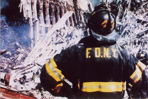
What happened a little over a
year ago created a big wake up call not only for American citizens, but to
citizens the world over. The attacks that were carried out were atrocious,
the attackers were cowards, and the loss of life and privacy is just utterly
sad. People are still mourning their loved ones a year on, and for many it
has come at a great expense.
GPS has played a big role in aiding to clear
ground zero. The Department of Design and Construction in New York
employed GPS technology in the latter part of the 12 months since the attack. There was
just short of 2 million tons of debris to clear from Ground Zero in the last 12 months,
which created a mammoth task for workers to achieve. Not forgetting that
Ground Zero was a crime scene also, and every piece of material, or object needed to
be documented, and what better way to do this with a GPS units so all of this
data can be collated and documented on computers to map out where the objects
may have come from within the twin towers.
After massive calls for help around the world
the DDC commenced using GPS technology and led the clean up process of
the once proud standing twin towers. All evidence had to be accounted for,
no matter how small or how large, whether it was human remains, or personal
effects, the need was there to document everything!
The DDC conducted a large review of technologies
and providers with help and assistance from many logistical, consulting and law
enforcement agencies and came to a decision to create a Broadband communications
network with time lapsed camera monitoring, GPS based vehicle tracking systems,
internet services to access related data and on-site staff to install, operate,
monitor and manage these systems.
The portable GPS units that were installed into
recovery vehicles worked from vehicle batteries, providing an AVL (Automatic
Vehicle Location) and could also be plugged into cigarette/accessory sockets
giving portability.

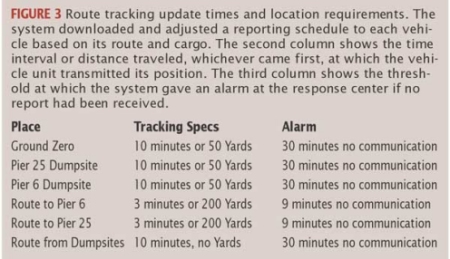
GPS requirements included to be able to track
recovery vehicles within an accuracy of 20 meters and did so in challenging
circumstances, not forgetting that anything that puts a block between the GPS
receiver and the GPS Satellite Network will cause problems with plotting, and
with Manhattans tall buildings and narrow streets and also considering the
amount of debris and sulphur in the air around Ground Zero, it was amazing that
GPS could still function through this thick cloud of foreign objects.
There were times where multipath induced errors would appear, accuracy was
generally considered to be at around 10 meters in unobstructed situations, which
then enabled people working at ground level to be able to "eye ball" the
recovery vehicles.
The GPS systems used were very similar in design
to the units we are all using on a daily basis with 1 second update intervals,
and enabled them to track the co-ordinates of vehicles at which time throughout
the day and could be configured to change the update frequency depending on the
material it was transporting.
This does bring down to earth how GPS can really help in
disaster situations like what happened on September 11th 2001, and the need for more
satellites, and even a European Space Agency run network of satellites.
For a full in-depth article on how this was
achieved, please check out the
GPS World article.
|


