|
Review by
Dave Burrows
Vito are well known in the Pocket PC arena for
small applications that help you get around the day to day usage of your Pocket
PC and enhancing the overall experience, but Vito have also created several good
utilities for GPS use. Vito have two specific products, SmartMap which is
a moving map product, and Navigator which is more of a compass and GPS extras
utility both of which we're reviewing in this review.
Introduction
Vito currently now have two versions of SmartMap.
One is a freeware version, and the full version costs $30. The major
difference between the two versions is you are restricted in the freeware
version to:-
-
track mapping of limitation of 500 waypoints
-
no positioning without track mapping
-
number of pushpins is limited to 10
Other than that, the two versions are identical in
features. SmartMap as we said earlier is a moving map product, and comes
with the following features available:-
-
fast rendering of Vector and Raster Maps
-
automatic detection of GPS Receivers
-
Support for Vector and Raster Maps
-
Exporting of recorded tracks to an ESRI Shape File
-
Pushpin Support
 Vito
Maps Vito
Maps
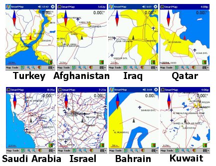
Vito are currently offering a whole selection of
maps on their website ranging from Europe, Middle East, Asia Pacific and Africa.
These map bundles are broken down into country sets and offer anything up to 15
maps per Country and are on sale for a standard flat rate fee of $4.
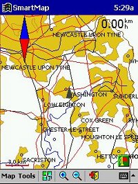
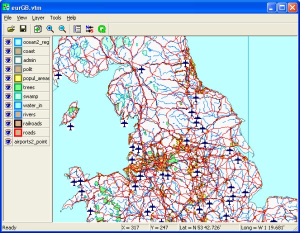
Taking a look at the UK map to the right, the UK is segmented up into 14 smaller
map territories which are aimed more for intercity travel. These maps come
calibrated (more on this later), and include various layers including:-
-
Settlements
-
Airports
-
Roads
-
Railroads
-
Rivers
-
Inland Water inlets
-
International borders
-
Trees
The map scale is set to 1:1 million.
I think that one thing Vito have to be commended
for is the availability of their maps. One question we get asked quite a
lot is for maps of far out foreign countries, many of which are in the middle
east, but there are very few GPS systems with pre-calibrated maps that will
cover these areas of the world, but Vito have managed this. You may not
have a 1:25000 scale map, but the maps are still very useful if you're
travelling to these countries, especially if you're backpacking or offering
relief work, and need to know where you are within the country.
 Calibration Calibration
The advantage of purchasing the maps direct from
Vito's website is that all the calibration has already been completed.
Normally when using moving map software, you can scan your own paper maps in, or
download maps from the internet or even draw your own maps, but the one thing
you then have to do is look at the map and either visit 3 or more points on the
map (corners of the map), and calibrate the map by entering the co-ordinates of
each position on the map, or you have to compare it with another mapping product
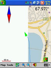
to gain the GPS co-ordinates like Microsoft AutoRoute. Calibrating maps
sometimes isn't for the faint hearted. You can calibrate the maps fine,
but when you start to use them, you suddenly find out how far out you really
were. This is the same for all moving map software, and calibration really
is a fine art. If you're not experienced, or you're rounding up or down
co-ordinates, or you mistakenly enter the wrong co-ordinates, then you could see
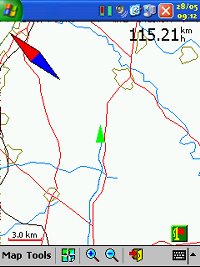
a problem like the screenshot on the right hand side. Although I had a 6
satellite fix and a 3D fix, the map I calibrated initially was around a couple
of hundred feet out. You'll see my journey actually going across
water, where in fact I was following the road to the right of the track.
The white edge designates the far left hand side of the map and I hadn't
envisaged this being shown as I thought I had the calibration spot on.
Obviously not! So this is why sometimes it's easier going for
pre-calibrated maps. Once you've had experience in calibration, then
you'll get better at this, the beauty of moving map software is that you can
scan your own maps in and calibrate, and use any map scale. Stitching maps
together on-screen once you've done this a few times gets quite easy.
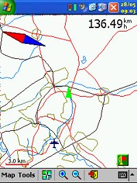
The first map below was generated by screen
dumping a well known mapping program, and cropping the screen and calibrating
it. The second and third maps are Vito's own maps, which are of the detail
level you can expect.

Map
Manager
Vito offer for free a third program which is PC
based. This is called Map Manager. Map Manager allows you to make a
digital map from various file types like ESRI, scanned maps or screenshots in
JPG format and also the tracks recorded by SmartMap. Once you've scan and
prepared colour vector electronic maps, you can download these to the Pocket PC
for use in SmartMap. MapManager imports maps in the ESRI Shape file
format, and converts them to VTM format, which is specifically developed by VITO
Technology.
Calibrating maps are fairly straight forward.
All you need to do is open up Map Manager, select LAYER, ADD LAYERS and point to
a JPG file that you've created as your scanned/downloaded map. This then
imports the map like in the screenshot below. Once imported, you can tap
on any area of the map and the SET POINT dialog box will appear. This is
for calibrating the map, and will ask for the full Latitude and Longitude for
the point you clicked on. You need to be as precise as possible here,
because if you are out on any of your cabliration marks, your position on the
map will be inaccurate. Ideally you really need to look at 4 or more
calibration points, a good start is to set the calibration points to the outside
corners of the map.
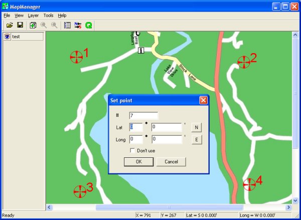
Once you've calibrated a point you'll see it
appear as a cross hair on the map above, and you'll also see the calibration
point number set against each one. Once you've created enough calibration
points, click TOOLS, SNAP and then the co-ordinates will be snapped to the map.
All you need to do now is to save the new map in the Vito VTM format and copy
this to your Pocket PC, and you're all set to use in SmartMap!
Digital Scanning of Maps and Downloading of
Digital Maps Disclaimer
All maps do hold a copyright notice to prohibit the copying of the maps. Please
check the terms and conditions of the copyright and your rights before digitally
scanning any paper maps or downloading of any digital maps from websites. Most
mapping companies will grant you a license to make at least one copy of the map
for personal use only, however please check first and if requested to do so,
request permission from the copyright holder first before scanning or
downloading the digital maps.
Ordnance Survey Copyright Restrictions
Permission to scan an Ordnance Survey paper map (which is less than 50 years
old) for retention on a retrieval system must be requested in writing stating
the purpose of scanning Ordnance Survey maps, scale of mapping to be used and
total area to be scanned in cm squared at original scale. Permission will not be
given if the customer can be supplied with an equivalent digital mapping product
from Ordnance Survey. A one off data royalty charge will also be applied,
calculated using the number of mapping units scanned, and the customer must hold
a Digital Licence with Ordnance Survey. |


