Overview
The digital mapping companies come in for a lot of criticism from the GPS user community. In particular there have been a lot of issues with missing roads, roads with the wrong names, bad junctions, and turn restrictions etc etc. There was a lot of concern in the forums with the currency of the latest TomTom maps released with version 5 software.
We wanted to put these issues to Tele Atlas and get some answers from them. At the same time we also wanted to discover the process that Tele Atlas (and it's customers) use to create digital maps, and then how they end up in SatNav products such as TomTom Navigator, or NavMan SmartST Pro. We also wanted to see what happens when mapping errors are reported and how they get incorporated into the map data.
Of course this was also a great opportunity to discuss specific issues with Tele Atlas that you , the users, wanted answering.
Well I spent 6 hours with senior management and product managers discussing all these items. |
 |
Tele Atlas Roadmap
Tele Atlas was formed in Holland back in 1984, became a public company in 2000 and last year acquired GDT in the United States.
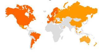
Working with various partners the Tele Atlas digital mapping products now are (or soon will be) available in varying levels of detail for a significant amount of the globe. There is still a lot of work to bring the maps in various parts of the world up to the standard of the US/Western European products, but there is a plan in place to achieve this.
|
|
Coverage
This brings us nicely onto coverage. There are 2 figures quoted for coverage in the Tele Atlas terminology: FA and BA. BA is Basic Attribution this data allows network routing and allows basic routing to be calculated, but will not be able to give detailed turn instructions. FA is Full Attribution which includes all the data required to provide the detailed turn instructions of the high level SatNav applications.
So what does this mean to us in plain English? Well most of the Western European countries have full coverage 100% BA and 100% FA. This includes:
- Austria
- Belgium
- Denmark
- France
- Germany
- Luxemburg
- Netherlands
- Norway
- Switzerland
- United Kingdom
Other Western Europe Countries are gaining in coverage over the next 2-3 years with full coverage predicted for all countries with the exception of Eire and Northern Ireland early in 2008. See below for more details.
Tele Atlas are also moving into what they call "New Markets". These include countries like Czech Republic, Greece, Poland, Hungary, Slovakia, Russia, and Turkey. For 2007 this will also include the following countries: Croatia, Estonia, Latvia, Lithuania, and slovenia. Here the mapping is also broken down into the connecting roads and major roads, as well as the FA and BA categories.
The Czech Republic, Poland and Hungary already have full connector and major road coverage, with other countries having 7% to 35% in place. This will improve over time. It is a different picture with the BA and FA categories for these countries but again over the next couple of years this state will improve as well.
In the USA Tele Atlas bought GDT and is currently working on merging their map dataset with the GDT one improving the quality and coverage of mainland USA. In North America (USA and Canada) 85% of the population live in less than 25% of the area. Tele Atlas are focusing their effort in proportion to improve the digital mapping in these areas. In South America there is already a certain amount of coverage in Mexico, Brazil and Argentina. This coverage will be expanded according to market demand. Market demand is normally driven by the auto industry, a car manufacturer installing SatNav generates the market for digital mapping.
Moving further afield through partnerships Tele Atlas is expanding it's product offerings to cover Russia, Singapore, Hong Kong, Malaysia, Australia, and a unique partnership will cover China. China is interesting as it is illegal to export the maps. This means that a data processing centre has had to be constructed in China, and any maps that are produced must stay within the country. Therefore if you take your SatNav to China then you must return the map data prior to leaving the country.
In addition to all this Tele Atlas will also continue to update and improve existing maps.
|
New Features
We talked about the addition of new features to add value to the data already in the database. There were no firm dates for this to be available for integration into navigation applications.
Tele Atlas will be adding value to the data already in the database. This will include better classification of road types, and adding speed limits. The addition of speed limits will include both actual speed limit and average speed. The actual speed will be dependant on the road class and the classification of the locality. Therefore a UK 'B' class road within town limits will be 30MPH.
Addresses will be enhanced to contain full postal codes where available. (Already implemented in TomTom version 5). This will then be further enhanced to include individual address points, these will be able to uniquely identify a single house.
The database will be enhanced to include extended signposting (turn information), lane information will be added for multilane roads, ad there be Enhanced Turn View pictures based on both lane data and signposts.
Tele Atlas will also be producing a "Truck Specific" prototype.
There will be a library of phonemes which will allow the phonetic input and output of information. These will apply to both street names and signposts. The phonemes are recorded by neutral native speakers of the various supported languages, making the data as natural as possible. This is available now for the Western Europe countries and in 2006-7 for the new countries. They will also be adding phonemes to POIs.
In February this year Tele Atlas created an alliance with MI International to provide POI Date in 16 European Countries. This will transform the current POI database of 1.2 million into a database of 25 million. This should then start to be seen in navigation applications.
Tele Atlas have a product called City Maps (not to be confused with any other product with a similar name). City Maps contain 2D footprints of all the buildings in a city. By the end of 2005 there will be 50 European cities covered and 20 US cities.
Tele Atlas will also be including a digital elevation model (DEM) which will have 30 metre contours. This will enable navigation applications to render a 3D representation of the road in a similar manner to that of Memory-Map, or Anquet.
In 2006 3D building Landmarks will be introduced. Initially there will be around about 1000 which will be implemented in 3D jpg format. Typically these will include things like the Brandenburg gate, Nelson's Column, The Tower of London, the Eiffel Tower etc.
Also in 2006 the 3D City Maps will be introduced. Initially these will be available for about 35 cities. Initially this will just be building height information allowing a reasonable representation of the street in 3D. This will be enhanced at a later point to include roof types and facades, allowing a "real world" 3D view of your journey.
My initial impression of the 3D demo was WOW, but after the WOW factor had worn off I started to question the practicality of it. It does look good, and would impress new users, but does it really add value to the driving experience. Time will tell...
|
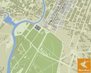
Tele Atlas demo 2d map

Tele Atlas demo 3D Landmark

Tele Atlas demo of simple 3D Map

Tele Atlas demo of full 3D Maps |
Making Digital Maps
Now to the part you have been waiting for: making the maps.
Interestingly the map data that Tele Atlas produces contains far more information than just roads. There are the basic attributes such as the road layout. Then there are the advanced attributes needed to generate routes, and then the turn features for advanced route guidance as used in the current SatNav products. But it doesn't end there. There are lots of additional value added components in the map data. These include addressing details. POI information, "signpost" data, speed information, turn restrictions, etc. You can see that a digital map contains far more information than a traditional paper one.
So how do Tele Atlas create the maps? Well they start with a number of data providers which they merge into a single consolidated database. Tele Atlas have over 50,000 data providers worldwide.
I will use the UK as an example here, but the process is the same no matter where you are. Actually I take that back. I will use Great Britain as an example. (I will explain later!)
The core of the Tele Atlas map comes from the Ordnance Survey. Although not the only supplier the OS provides the major input for the database, TeleAtlas also have their Field Survey vans and staff, high resolution Aerial Photos and paper maps also provide input for the database.
All of this data is consolidated into the "TA Map Workplace" this also includes any updates that are introduced as a result of the Map Error process (detailed below). The processing for the data is done in India, though due to the restrictions imposed by China a second data centre will be opened in China. If anomalies are found then these are escalated for investigation in a field survey.
|

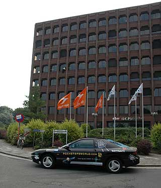
The Tele Atlas field survey van outside TomTom's offices
|
This provides the core of the Tele Atlas database. This is then enhanced with georeferenced data such as POIs and then 3D Landmarks, the phonemes etc. The fully consolidated database is then published 4 times a year as a Tele Atlas Mapping Product in a format known as MultiNet.
Now there is a certain amount of time required after the last updates have been entered into the database and checked before the data is released. This allows the data to be tested prior to sending out to the application providers. By now the map data, although being the latest available can be considerably out of date and it has not got to the application builders like TomTom or NavMan yet. The OS data will have been of a certain age prior to being delivered to TomTom, and the aging process gets longer with each stage.
Finally the MultiNet data is delivered to the navigation application builders. They then have to process the map data and tweak it and compress it and then test it and finally fit it into the next available release or update of their products. In some cases the conversion and compression process can take a month or two.
So with this in mind tracking back from the release date of a product we can see when the "latest" changes can reach the database. I will use TomTom as an example as they normally release annually in May. This means that the Tele Atlas map release from Q1 is missed because it does not fit into the timeframe. The Q4 map release is the baseline for the release, this was released from TeleAtlas in November. Now assume that it takes Tele Atlas 1 month to finalise and productise the map release, we now have maps that cannot be later than October, but it doesn't end there. Tele Atlas will not have received and integrated the OS data on the last day they will probably get it at the start of the quarter, so the core OS is possibly the latest available in August. Now I don't know what the OS release schedule is but I would be surprised if this will coincide. You can see how this all builds up resulting in the "Latest Available" maps being possibly a year old before they hit the shelves of your local GPS dealer.
Tele Atlas are aware of this latency in getting the most up to date data to market and are working to try and cut down the amount of time from update to release.
I haven't covered the work put in by the Field Survey Teams here. We will be visiting Tele Atlas in the UK in the next few weeks and will be covering the process of Field Surveying and how it improves the Tele Atlas data.
So that should give you an indication as to the process followed to create the mapping data for navigation applications. But "What about Northern Ireland?" I hear you ask. If you go back to the start of this section you will see that the core data comes from the Ordnance Survey. The OS provide very good and detailed mapping for England Scotland and Wales. They do not maintain the maps for Northern Ireland, this is done by Ordnance Survey of Northern Ireland and they do not provide the core data in the same detail as for England, Scotland and Wales. The same is true for all of the countries with poor coverage such as Eire, Portugal, and parts of Spain. |
Map Errors Process
When we visited TomTom recently I asked about the error reporting and correction process and how they prioritised error corrections against map development. At the time I didn't get an answer that I would consider publishing. I wasn't too bothered as I knew we would be meeting Tele Atlas and I would have a better chance to question them about this process then.
So what happens when you submit an error to Tele Atlas?
First and foremost I am assured that every single report is reviewed. Tele Atlas work to a standards based methodology for process improvement. What that means is that they must have a defined way of processing not only new data, but also handling errors and omissions. So how does this work and is this just a lot of red tape?
Firstly some figures: In 2003 there were 12,000 errors reported of which 10,000 were reported through Tele Atlas partners, and 2,000 from users. In 2004 this rose to 30,000 with 10,000 reported through partners and 20,000 by users, and the predictions for 2005 are 50,000 with 12,000 reported by partners and 38,000 by users. This dramatic increase has caused a few issues in Tele Atlas which they are addressing, including feedback to the users reporting errors.
Users of popular SatNav systems contribute the majority of error reports in the system. Unfortunately around 30% do not contain enough detail to be actioned. A report such as "Roundabouts have been taken out and replaced with junctions. Street name: Bath centre (Bath, UK)" does not provide any specific data that can be corrected. Whereas "This is a one-way street from South to North not shown on my TomTom Go. Street Name: Wray Lane (reigate Surrey, UK)" is much more exact and can be entered into the system.
When a fault is entered onto the system around 50% are found to have already been fixed, either by new data having been entered into the database, surveys, or as a result of an earlier fault report. The rest of the reports enter the change control process. My understanding of this is that if a substantial number of people report the same error then Tele Atlas will prioritise this and fix it. If on the other hand only 1 or 2 people report a map fault then this will wait in the system until sufficient reports have been made to raise it's priority.
When an error is fixed it will be incorporated into the next release of the database to the application builders. These fixes will then start to appear in the next release of the Navigation Application. You can see from this and the previous description of map creation that it can take over a year for any reported errors that are not automatically corrected to be fixed, but only if enough people report them.
Whilst I understand this system I don't totally agree with it. I am far more likely to report that my street name is not correct than someone who cannot find it, but I am likely to be the only one who will report it. Tele Atlas may be passing up a good opportunity to improve the overall quality of the maps by missing the one off reports.
Interestingly my road which only contains 15 houses numbered up to 24 (more houses on the even side of the road) on the Tele Atlas map data only recognised house numbers 50-50. Now I could never be bothered to report this. I wonder how many others faced with the same error don't report them. I am pleased to say that in the latest data this has been fixed, but NavTeq still shows 50-50 in Destinator 3.
I was also informed that all the major roads of Europe are subject to an annual field survey, but that they would not divert a van to investigate an error report even if it is only a few hundred yards off the major road, possibly another missed opportunity.
|
| PocketGPSWorld.com Questions |
|
| Do they only supply the latest data or can the likes of TomTom etc. obtain older compilation at a reduced cost. |
Tele Atlas only provide a single product and it is always the latest available on their system. |
|
| Why does it take so long to correct errors? I have errors which I reported over a year ago which are still not actioned. |
See Making Digital Maps above |
|
Do they make up street names? Many names in the Stratford/West Ham area of London arecompletely wrong! Can anyone really, for instance, confuse Field Head with Gay Road? I know that there are other areas which suffer the same problem.
|
No these are obtained from the Data Partners, either Ordnance Survey or Local Planning Depts. Bear in mind that the data will be converted by the Navigation application company and errors can creep in here. |
|
| How do they prioritise which updates to include in a new release? |
Priority is given to core data providers then reported errors as described above. |
|
| Do they actually look at the error reports sent in via the form on their website? |
See Error Reporting above. There will soon be feedback available for error reports on the Tele Atlas site. |
|
| Why are end users not allowed to modify the map data, even to correct mistakes? |
Which data would you modify? The base Tele Atlas data is not on your navigation system. The software you are using has complex encoding and compression applied which makes this impractical. |
|
| Is there any chance they would merge with NavTech to collate resources and stop redundancy? |
Mikes Comment "I would hope that they don't. Collating resources and creating a monopoly is not a good idea in my mind. competition keeps them honest and striving to be best". They said no as well. |
|
| When we get maps from Baltic countries? |
From the Road Map the Tele Atlas Baltic Coverage will start in 2007. |
|
I would really like to know whether road width is a differentiator as far as road quality is concerned. The TT routing algtrithm is dangerous when using a large vehicle and most of the problems are down to its use of 'inappropriate roads' - many of which are simply too narrow for larger vehicles.
How do TeleAtlas identify those roads to TT? Are they the same as any other B road or are they catgorised separately? If so is it the TT coding that doesn't take notice of such things or is it a weakness in the maps purchased by TT?
|
There are about 9 different categories of road that Tele Atlas maintain. These range for major motorways to single lane tracks, each of these are represented individually in the database sent to Application Builders.
I assume you are talking about truck routing, and possibly RVs and caravans. This is an issue to raise with TomTom.
Teleatlas are to trial a truck data set the results of which will determine if it will be productised. |
|
| Plaese ask them why they are providing sub-standard maps to UK customrs using TomTom. |
They provide the same data to all clients. |
|
Why does it take so long to correct their existing UK maps to reflect road changes?
I agree with previous posters about data entry errors. I guess if my anti-virus, anti-spyware, anti-whatever can update data almost on a daily basis then maps should be updated on a daily/regular basis too. |
See Making Digital Maps above
You are talking about something completely different AV, AS etc are standalone and isolated. The map data is provided in a fixed format to all Application Builders, each application builder then creates their own proprietary file structure. This is NOT a database as the systems simply do not have the processing power to run a relational database system and do the routing, tracking etc. This means that the Hardware architecture will not support this type of update system. |
|
| Not only does it seem good practice there is also (IMHO) a health and safety aspect attached to it also. |
We don't understand this comment. The Driver is the sole person responsible for the safety of the vehicle. |
|
| I'd also like to see software/hardware provision reflect present usage patterns in the sense that I guess most people with a PDA (Windows based or Palm) will sync with a laptop, PC or both. It would be fine and dandy for software to interact between PDA. PC and laptop and allow workflow along the lines of plan routes from PC/Laptop then send them down the wire to PDA possibly with a view to returning the actual routes taken up the wire from PDA to PC. |
Yes but most users of Tele Atlas data are not PDA users. |
|
| lets hope the car makes it |
It did easily, despite the weather! |
|
| I think I'd be interested in a comparison of their roads data update policy against standard printed road atlases, e.g. the excellent Philips Navigator 1½ miles to the inch Atlas, updated yearly and costing around £20 a time (before discount)... |
There is no comparison. How do you know if the Phillips is up to date? How would you recognise any error in it?
At this scale Phillips provide a tiny fraction of detail compared to Tele Atlas full street level mapping.
Phillips have no Routing capabilities, etc etc etc. Now you pay £20 for the paper and £33 for full maps, new application and routing etc. (TT5 Upgrade) I know which I would choose. |
|
| It would be interesting to find out how much of TeleAtlas' 'business' TomTom represents. This could be hard to ascertain as they might not want ot say, but it would be interesting to judge the apparent problems we as users of tomtom are having against the level of business that we represent. In other words, they dont have to give a s**t as they couldn't really care less whether or not we are happy |
Well Tele Atlas estimate that they have 63% of the Personal Navigation Market in Europe and that TomTom represent 35% of that market.
I can assure you though that Tele Atlas do care about the quality and coverage of their data. |
|
| Will you admit it if you get lost? |
Em Do I have to answer this one? In honesty I can say that I pretty much didn't have a clue where I was going, my GO700 got me there. I did of course ignore one important instruction and went on a very interesting detour around Amsterdam. Getting out of Amsterdam was also a little interesting as I had been in an underground car park and the GO didn't get a strong fix for quite a while. But lost no I was never lost. |
|
In past Pocket GPS World interviews they have not sounded very interested in Ireland mapping.
Why are they at least two years behind NavTeq who have a full time team here in Ireland and will have the country fully mapped by the end of 2005? I always get the impression that they were caught on the hop with NavTeq's initiative. For what it is worth: I ditched Navman after they went to TeleAtlas because their maps fell way behind NavTeq's. |
Tele Atlas are interested in Ireland (and Portugal and Spain) it is just that they need to improve their data sources.
I suggested that if they diverted all their Field Survey vans to Ireland they could cover most of it in a few months. Although for the company this would not make sense.
They agreed that it is possible to get most of the core data this way, but then it would need to be processed in India, and would still take a long time to get to a marketable product, at the expense of all other Field Survey projects.
The most important Field Survey project to Tele Atlas is the major interconnecting roads throughout Europe, these they survey once a year.
Tele Atlas are estimating 80-90% coverage of Ireland in 2006. |
|
| Ask them "So, now TomTom have decided to use Navteq for the Rider, do you think that TeleAtlas will wake up, smell the coffee and start discussing their options for TTN6, which seems that TomTom will allow customers to choose which maps they want and help resolve some of the map errors customers are reporting? |
I am not sure what you are basing the assumption that TomTom will be using NavTeq in anything other than Rider from. To the best of my knowledge only the Rider will have NavTeq map data. |
|
| I wonder when they will separate out the application from the maps, a bit like Mapopolis. Why not make the application with some very basic maps free, or available at a low cost and then charge for up-to-date content. |
As far as Tele Atlas is concerned there is no connection between the maps and the application.
For TomTom this would be a commercial decision that they would have to make. |
|
| Couldn't agree more. Can you ask them why it takes so much longer to update electronic maps which SURELY must take longer to release than old-fashioned paper!!!!!! |
Updating maps is an extended process due to the fact that there are no standards within the industry. Tele Atlas provides map data 4 times a year to the Application builders. Due to the hardware restrictions these have to be encoded and compressed in a proprietary by each application builder.
It is a commercial decision on the part of the Application Builder (TomTom, NavMan, etc) as to how often they provide map updates. |
|
| What about a subscription service where updates are sent to the user the same way as anti-virus updates are distributed???? |
With the current architecture of the applications and the restrictions imposed by the hardware it is impossible to provide incremental map updates. Therefore each time map data is changed the entire map would need to be re released. In the case of the GO700 this would mean a download of over 1Gb for each change. |
|
| What about including SmartSTv3 as an option to those of us who have bothered to report mapping errors to TeleAtlas??? At the moment on the TA website, you HAVE to choose your software as part of their reporting process and there is nothing past v2 and no iCN510 on there either!!!!! |
I pointed this out to Tele Atlas and they were going to investigate. |
|
would it be impossible to teleatlas to come together with TomTom to create a better mapping system.
For example, tomtom buys the maps (no doubt for a fortune) and teleatlas updates them. But they find out about changes the hard way but retracing the routes and contacting road authorities for details. Many roads are either missing or are named incorrectly because of this and amendments like new roundabouts etc take ages to collect. The TomTom program could accept changes to the maps at the clients end. Basic stuff only. Then when synchronised the data can be fed back. Say i come across a road without a name on TomTom but i know the name, i can enter the details, this can be stored as a text entry with a location guide and this could be sent back to TomTom. TomTom could then either sell this information back to TeleAtlas (which in time would pass a saving to the customer) or rather trade the information for map updates.
This could function the same was the speed camera POI system works by accepting new data from the clients. |
Tele Atlas would love this, but it is not likely. for a start TomTom although a large customer of Tele Atlas is not the only one.
Secondly (and no disrespect to anyone here) why should they believe a user more than the planning or mapping authority that provided the original data?
I did actually propose that it would be possible to have a select group of clients who had the ability to record tracks and send the tracks back to Tele Atlas for map verification. But what happens when you drive over a field?
The analogy with the speed cameras doesn't really work. If a cam is in the wrong place it will not really matter. If a road or a roundabout has changed then these will need to be surveyed either by Tele Atlas or the source of the original data, so it will still have a long lead time.
Tele Atlas are however looking at trying to minimise the delays in getting mapping changes to market. |
|
Im not certain but at the minute i would guess there isnt a system for updating just a section of a map, this NEEDS to be introduced! When can we expect it?
are their any thoughts as to a customer vs map production company contract. I would be willing to pay more if i knew that the maps we have already paid for were to be updated within a minimum time scale. For example, if i spot a new roundabout and inform TeleAtlas about it, i would expect a update available to amend my maps by say 3 months. Does teleatlas have any future ideas that would follow this idea? |
Not technically possible with current hardware architectures. The systems simply don't have enough power to run the sort of database systems that would support this sort of functionality. |
|
I've just tried to move my poi's from Navigon (navteq) to TOMTOM (Tele Atlas). It's amazing how much better quality the Navteq data is.
The accuracy of the road names and the availability of the POI's in Tele Atlas is very poor compared to Navteq.
What are they going to do to improve this?
1. In Navteq the Orient Car park (Trafford Center) is listed. In Teleatlas just the Trafford Center is listed - no detail on parking.
2. Blue Planet Aquarium is listed in Navteq - not in Teleatlas even though the road to it is there.
3. Cannon Hall Mueseum & Gardens present in Navteq - missing in Teleatlas.
4. Central Retail Park (Great Ancoates st - Manchester) present in Navteq - missing in Teleatlas. Even though the road system within the park itself is present. |
What you are talking about is not the quality of the maps per se, but more the POI data supplied. Currently Tele Atlas have 1,200,000 POIs whereas NavTeq have 1,800,000. This will be changing in the near future as Tele Atlas have signed a deal with MI giving them access to 25,000,000 POIs.
It remains to be seen what quality these POIs will be, but they will certainly have more data than NavTeq. This doesn't meant that an Application Builder will include them all in their products though. |
|
| Do they supply their map data to any car manufacturers for the built in systems, and if so how often do they update the map data for them. |
Yes. The map updates are available to all application builders (Car Manufacturers as well) four times a year. |
|
| A mate's TomTom 5, when set to the shortest route sometimes takes him off at a motorway junction, only to take him straight back on (it cuts the corner) which is obviously a stupid thing to do. Is this a Tom Tom problem, or a problem with the maps themselves? |
This could be for a number of reasons, map data error, conversion and compression error, speed profile errors, etc. Take it up with TomTom in the first instance, and be specific about the route. |
|
| Please ask them why the latest TOM TOM map update is so inaccurate, major road changes of 12 months ago are still not included. |
See above |
|
Why if you have purchased the recent upgrade can you not get updates to rectify the obvious errors within this last update.
I am very disapointed with the accuracy of the maps.
I'm the same, I was so disappointed to find I had paid good money for my upgrade to TT5 only to see that none of the newish roads in my area had been added. To make things worse TT expect me to pay a monthly subscription to get any future map updates! Considering how slow TeleAtlas are this sounds like a complete waste of money. Even if they do get their act together I think anyone who has bought TT5 should get at least 1 free map update after they've fixed the data. |
Due to the timescales involved it will probably take 24 months for errors that are not fixed automatically to get through to the consumer.
It may be the case that none of the newish roads in your area were included, but they certainly were in other areas.
This has been one of my major campaigns with mapping companies over the last 3 years. This is not a problem specific to TeleAtlas, all mapping companies have these issues. |
|
There is such a significant disparity between the price of the same TeleAtlas maps (data) provided via GPS software providers like TomTom who buy maps from TeleAtlas, and the map CDs supplied directly by TeleAtlas.
I have a Ford Focus which has a built-in radio/GPS, and map CDs from TeleAtlas for that cost approx. €150 for each country whereas I can get an upgrade from TomTom for all Western European countries for just €59.
They don't do upgrades/subscriptions for existing customers (for map CDs for cars) but force you to purchase a full "licence" each time you "upgrade" your map CD as an existing customer. |
Tele Atlas sell products from it's partner companies on their site. The pricing is a commercial decision on the part of the partner company. |
|
ok, it looks like one question its about Portugal Map. tks.
U can't imagine what is just 43% of coverage in my country.
I have a long way till i start to complain about just one or 2 street's with a wrong name. A dream so far. |
We were in a similar situation in the UK just over 3 years ago. This has improved dramatically since then, though sometimes you wouldn't think so.
Having said that if Portugal get 100% coverage I wont have any excuses for not being able to find my in-laws house will I? |


 Article by Mike Barrett


