 Review by Darren Griffin Review by Darren Griffin
Introduction
Rarely has a new device been so eagerly anticipated as has Satmap's Active 10. Combining all the features of a traditional handheld outdoor GPS with full colour mapping from Ordnance Survey, the Active 10 is waterproof and hailed by Satmap as 'the ultimate sports GPS'.
We first made mention of Satmap's Active 10 back in March 2007 having seen it on display at the NEC Outdoors Show. Shortly afterwards we had another opportunity to see it when Satmap attended our GPS Expo at Sandown Park in April. Even though the halls were filled with GPS users all used to seeing all manner of devices it still caused many ooh's and ah's when shown. The device was still at an early stage in its conception and the software was far from complete but it was clear even then that Satmap were onto a winner.
 |
So has it been worth the wait? The Active 10 went on sale late last year and such was the demand, Satmap had problems fulfilling orders let alone supplying units to press for review. However our turn finally came and PocketGPSWorld have had a review unit for a few months now. I think it only fair to let you in on a little secret, it's a bit of a gem! It's not without problems but despite the odd niggles it offers functionality never before available in a single water tight package and what it does is done well.
We'll try to cover every facet of this device in our review and we may even add sections if we discover areas that we have missed or that deserve closer scrutiny. This is a warts and all review and so we will mention any failings so that you are in possession of all the facts. |
Early prototype |
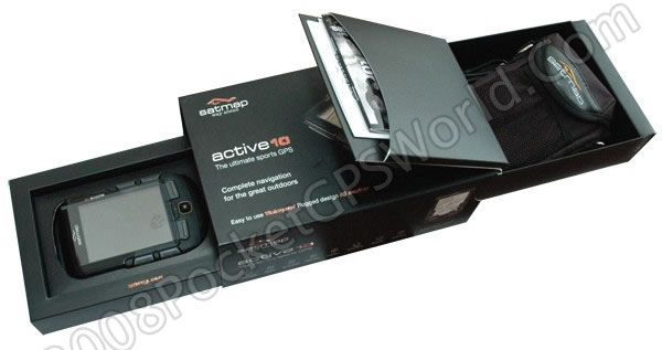
In the Box
We have always made a big thing of the packaging and perhaps in this carbon conscious climate we ought not to do so. But I make mention of the packaging for one simple reason. Well designed and thought out packaging demonstrates a pride and commitment to the product contained within.
Satmap are clearly very proud of their device and the packaging reflects that. It has clearly been given a lot of thought. Not only is the box it comes in made from re-cycled card (no blister pack plastic in sight here) but it presents the device and accompanying accessories in a pair of drawers that concertina out from either end of the box.
In one drawer you will find the Active 10 unit itself whilst in the other under a lid (that contains the quick-start guide, warranty card, end user licence agreement and map catalogue brochure) is a case, lanyard and USB-mini-USB cable.
All that needs to be done before proceeding is to insert the supplied disposable batteries (these are the Energizer Lithium cells which are the most powerful AA battery available to date) and switch on. The unit has been designed such that it requires no interaction with a PC at all. As supplied, the Active 10 comes with three types of pre-loaded base maps. A whole of Great Britain map at 1:1,000,000, a large scale UK road map at a scale of 1:250k and a vector based detailed street map that contains minor roads, railways,
waterways, rivers and coastlines in a standard map colour scheme.
To get the most out of its intended purpose you will need to purchase an Ordnance Survey map card containing the area(s) and scales you need and we will cover this in more detail later.
However, all the functionality of the unit is present whether a detailed Ordnance Survey map card is present or not. Because of the pre-installed map and the fact that additional maps are supplied ready to go on SD memory cards you can simply insert them and get going, no need to mess about installing maps from a PC, for some that will be music to their ears, even for a seasoned computer geek I don't relish all the messing about that such a process often entails!
Design
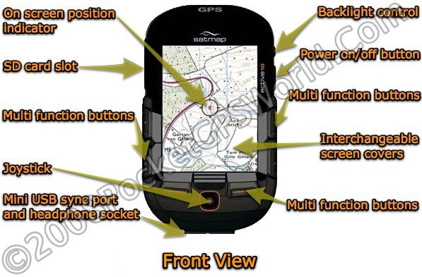
The Active 10 has a familiar design similar to many PDAs with a portrait format screen and a size that sits well in the hand. It has a tough ABS shell and a rubberised coating on many of its panels which aid in gripping the unit. Rubber covers are present over the SD card slot and mini-USB port.
However, unlike the vast majority of PDAs available, the Active 10 does not have a touch screen. Instead a number of multi-function buttons surround the screen, two at each side and two at the bottom accompanied by a small thumb operated joystick.
This may at first glance appear to be an odd decision but once out in the field you quickly understand why this design makes the ultimate sense. All the features of the unit can be operated using gloved hands with no stylus required or there to be inevitably lost. It also means no delicate touch screen is required and instead a user replaceable polycarbonate screen cover is present that can be replaced quickly and easily if it becomes damaged.
The battery cover at the rear is protected by a gasket around its circumference. The cover is opened by turning the small metal 'D' buckle which unlatches and releases the cover.
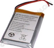
As supplied, the Active 10 comes with the alkaline battery tray installed. If you purchase the Lithium Polymer rechargeable battery option this tray has to be unclipped and the small plug connecting it to the unit disconnected to make room for the larger battery.
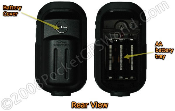
The all important GPS side of the device is the ubiquitous SiRFStarIII with a built-in angled antenna at the top of the case. In the hand the device fits very comfortably with your fingers curving around the indents in the battery cover and the angle of the GPS antenna resting atop them. The joystick and 4 of the 6 buttons fall easily in reach of the thumb with the two on the opposite side requiring your other hand to use.
In Use
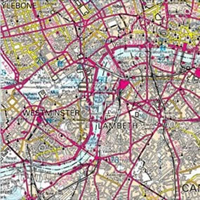
For the review I received the Southern GB Landranger map at 1:50k. Pressing the power button reveals the Satmap splash screen shortly followed by a brief flash of arrow cursor hinting at the Windows CE operating system that runs underneath before the GPS Status screen is displayed. Our units was running v1.15 which was the latest at the time we received the unit, current units will now be running v1.16. Although currently, firmware updates can only be carried out using an SD card supplied by Satmap it is planned to make such updated available on Satmap's web site in future.
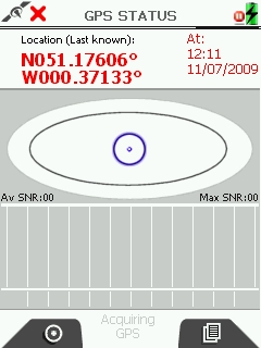 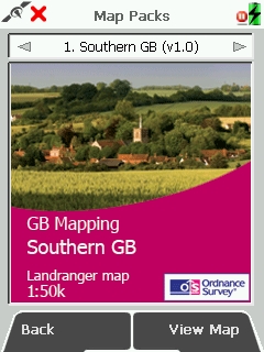
GPS Status and Map Pack Screens
I'm going to try and cover the power aspects of this device in some detail as, being a device intended to be used far away from any external power sources, this is a critical area. Out of the box the Active 10 comes supplied with an AA battery carrier and 3 x AA batteries. An optional LiPo (Lithium Polymer) rechargeable battery pack is available at extra cost.
If you are using AA type batteries the results you get will vary vastly depending on the type and quality of the battery you use.We have in testing had usage times that vary wildly from as little as 18 minutes with cheap AA Alkaline batteries to over 14 hours on Lithium cells.
 We would consequently always recommend that if you insist on using AA cells you stick to the type as supplied by Satmap, namely Energizer Lithium cells. These are the most powerful AA batteries available to date and will give you the best run time albeit at a cost, at time of writing this was approximately £5 per set of 4 although we have also seen them at £7 for two! We would consequently always recommend that if you insist on using AA cells you stick to the type as supplied by Satmap, namely Energizer Lithium cells. These are the most powerful AA batteries available to date and will give you the best run time albeit at a cost, at time of writing this was approximately £5 per set of 4 although we have also seen them at £7 for two!
Clearly at those prices you would quickly repay an investment in the optional LiPo (Lithium Polymer) rechargeable battery pack option and I would strongly recommend that this is a 'must have' option. Whilst a set of AA's and the AA battery carrier is advised as a back-up, for frequent use the LiPo battery pack is in my opinion essential.
Even with the screen left on constantly and at full brightness I have had run times of 9+hrs with the LiPo. With careful management of power, normal settings for screen brightness (70%) and power save configured to blank the screen after 15 seconds you can easily achieve 24 hrs from a single charge. I should add as a caveat that usage times will vary considerably dependent on how you use the device but between 9 and 24 hrs are reasonable figures for the LiPo battery.
Power and Back Light Control
This does assume that your usage patterns allow the option to recharge the battery every 24hrs of course! If they don't and you will be away from mains power for an extended period then your options are either a healthy stock of AA batteries or perhaps a solar charger or better still, a solar rucksack such as this which could be used to constantly top up the LiPo battery.
One issue I have observed is the time required for the initial fix on the Active 10. Although it is equipped with the ever popular and sensitive SiRFStarIII GPS chip-set, it takes a great deal longer than other similarly equipped receivers in acquiring its first fix from a cold start.
The chart below is an average of the Time To First Fix (TTFF) times recorded over four weeks of testing. All devices use the SirFStarIII chip-set although the Holux has the later LP (Low Power) variant. It clearly shows that the Active 10 is slower than the other devices in acquiring the initial cold start fix.
However, once that fix has been calculated it proved very sensitive and was able to hold on to a signal and calculate position under marginal conditions such as heavy tree cover or where other physical obstructions reduced signal quality.
The chart also shows that once the first fix had been achieved, subsequent warm starts were calculated within the time that would be expected and indeed the figures reveal it to be very fast in this regard.
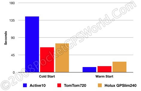
Time To First Fix Chart - Average times calculated over 5 weeks usage
Initially I was concerned about the length of time required for the first fix. As the Active 10 proved to be very sensitive once this had been calculated it became much less of a concern and I quickly got into the habit of allowing it the time it required to calculate its initial position whilst I prepped for the walk.
There is currently no provision for an owner to record their details in the unit which given its cost is an omission I hope Satmap rectify in a future update. Something as simple as an Owner Screen, displayed on every start-up would suffice with the data being secured by a PIN number perhaps?
Route Planning
If you have ever tried to plot a route using some mapping GPS handheld's you'll know how painful this key process can be. Planning a route on the Active 10 is remarkably straightforward.
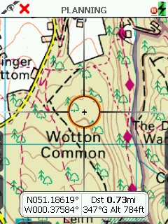
To create a new route from scratch call up the Routes Menu, select Create New Route and then using the Zoom In/Zoom Out controls and the joystick locate your start point.
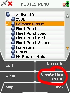
Routes Menu
Once you have the cursor centred on your start position click the Joystick to set it as the Start Point. This is marked with a green 'blob'. Then you locate the next way point and click to record in the same fashion. As each way point is added they are joined to the preceding one by a Yellow line to clearly indicate the chosen route. Simply repeat this process for each way point and when finished, click the Done soft key to save the route.
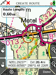
Creating a route, the yellow line is the plotted route
Ordnance Survey mapping © Crown copyright. Media AM70/08
The route will be auto named e.g. My Route 1 and you can easily rename this to something more memorable by selecting the Edit soft key and then choosing Edit Title. Everything is straightforward and immediately obvious.
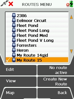
New route created My Route 10
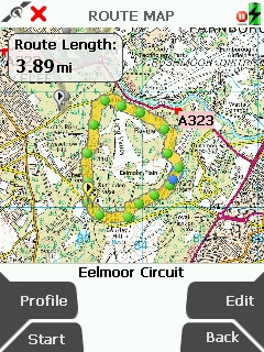
You can also enter way points using the OSGB Grid reference. For all the routes stored on your device you can select a preview of the route and see route profile and route card pages:
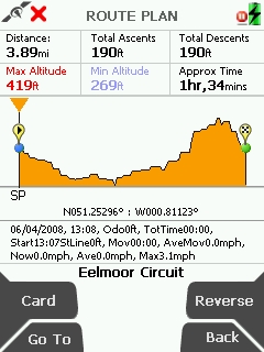 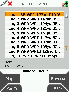
Route plane with elevation data and Route Card with Way point Information
On The Trail
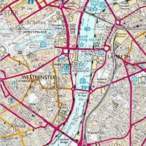
With your route planned all you need to do is select it and press "Start". Once you have a satellite fix you can press the centre location button and you will then be presented with the OS map and the cursor set at your start point.
There are a number of on-screen text boxes you can have overlaying the map. The information these contain is user configurable from a vast list of options such as Trip Distance, Heading, GoTo Bearing, Bearing to Next Way Point, Distance to End etc and there is a choice of a box with two fields of information or four, all of which can be enabled or hidden with the click of a single button.
Map showing 2 Data Box layout
Ordnance Survey mapping © Crown copyright. Media AM70/08
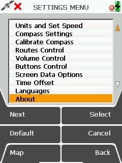
The compass is worthy of mention at this point, it is an electronic compass rather than simply a pseudo GPS compass and so will function when stationary. Before use it needs to be calibrated which is done by placing it on a level surface or holding it level and then rotating it in two full circles.
Once calibrated it operates as you would expect with a standard compass rose and an information box that shows the heading. The heading data is derived from the electronic compass below a speed that can be configured in 'Settings' and from GPS derived data above that speed. If you have an active route it can also be switched to a Pointer mode which gives you a bearing and distance to the next active way point.
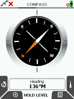 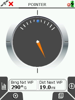
Compass and Pointer Log Screens
As your journey continues the trip is logged and you can see on screen your actual route as compared to the planned one. A trip log screen is available which contains a wealth of information. This can be left to operate as a cumulative trip record of all your travels or you can zero it each time you set out.
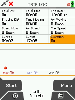
Trip Log and Main Settings Menu
When you have completed the trip you can convert your track into a route if you wish. This is an easy way of correcting errors you may have found in a pre-planned route.
I found the back light excellent when being used in bright sunlight. Set at the default 70% setting I was able to read the screen easily in most lighting but on the few occasions where it was too bright to do so easily all you need do is press the back light button. This temporarily boosts the back light to 100% and this made the screen clearly readable in even the brightest sun light.
It is waterproof and we did get very wet testing it!
One issue that could be described as mildly irritating is that when in navigation mode, should you accidentally knock the joystick this switches the unit into planning mode. This happened to me on a number of occasions and I know from feedback that it is an issue that could do with being addressed.
Another that affected me a couple of times was the back light button. It is located adjacent to the power button and on two occasions I switched the unit off when I had intended to boost the screen brightness, very annoying!
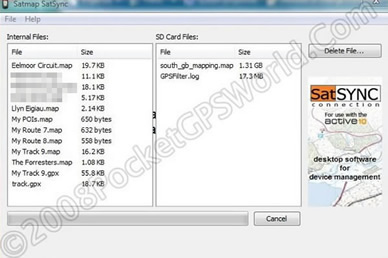
SatSYNC
 SatSYNC is Satmap's PC software for the importing and exporting of routes. It is Windows only software (come on Satmap, Mac users have been around for a long time now, there really is no excuse for not providing Mac compatible software) and allows you to: SatSYNC is Satmap's PC software for the importing and exporting of routes. It is Windows only software (come on Satmap, Mac users have been around for a long time now, there really is no excuse for not providing Mac compatible software) and allows you to:
- Export and store routes on your PC
- Import routes from your PC to your Active 10
- Manage the SD card and internal memory of your Active 10
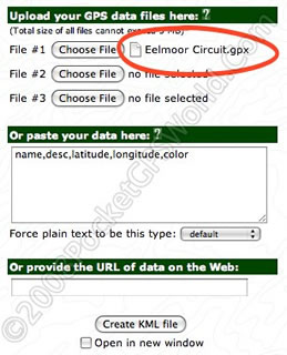
The Active 10 uses .gpx (GPS eXchange Format) files. This is a common format and many sites already have walks and other routes in .gpx format. If you have a route in another format there are many utilities available that will convert from and to .gpx including GPS Babel and GPS Utility.
SatSYNC Desktop Software
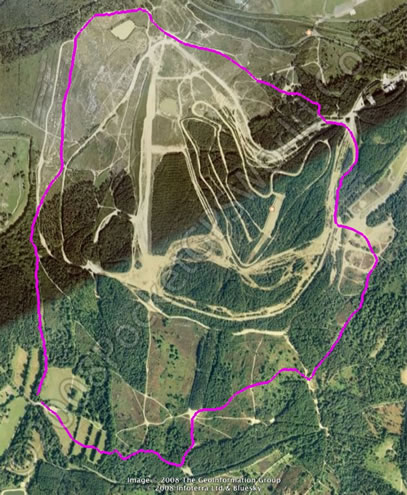
Routes created on the Active 10 or converted to routes from actual track logs can be exported to the PC using SatSYNC and then viewed in Google Earth via utilities such as GPSVisualizer.
Ordnance Survey mapping © Crown copyright. Media AM70/08
So the route file on the left is exported to the PC and then using GPS Visualizer's web upload form (above right) is exported. The resulting .kml file is visible in Google Earth as seen below:
Plug and Play Ordnance Survey Map Cards
All the maps available for the Active 10 are supplied pre-installed on SD map cards. There is no installation as such, simply plug the card into the Active 10 and you're done. Maps cards can be installed and removed whilst the unit is switched on and this worked very well. Technically you could even swap map cards between friends as the licence is attached to the card itself.
  There are currently over 150 maps available covering the whole of Great Britain at 1:25,000 and 1:50,000 scales with more titles being added. To make choosing your map simpler they have divided the country up into regions so you do not need to know the number of the map area you need. There are currently over 150 maps available covering the whole of Great Britain at 1:25,000 and 1:50,000 scales with more titles being added. To make choosing your map simpler they have divided the country up into regions so you do not need to know the number of the map area you need.
- National Parks (1:25k and 1:50k)
- National Trails (1:25k and 1:50k)
- Regions (1:25k and 1:50k)
- Counties (1:50k)
If the map area you require is not covered on one card Satmap have a custom service which allows you to create your own custom map region (available in 30 to 90km tiles).
Examples of the map coverage available:
| |
National Parks
- Ben Nevis/Glencoe
- Dartmoor & Exmoor
- Lake District
|
National Trails
- Hadrian's Wall Path
- Offa's Dyke
- Ridgeway
|
|
| |
Counties
- Bedfordshire
- Cumbria
- Powys
|
Regions
|
|
| |
Compilations
|
Site Centred
|
|
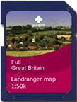
Below are two small sample tiles which indicate the difference in detail available between 1:50k and 1:25k maps:
1:50k on the left, 1:25k on the right
Ordnance Survey mapping © Crown copyright. Media AM70/08
Accessories
A range of accessories is already available for the Active 10. These include a bike mount that allows your device to be securely mounted to the handlebars or handlebar stem of your bike, a set of three spare screen covers, cases, lanyards and the power bundle.
The power bundle is worthy of coverage in its own right. It includes a 2700mAh rechargeable LiPo (Lithium Polymer) battery pack, a multi-region mains charger, a USB lead to connect the Active 10 to the charger and a 12v cigarette lighter charger.
The LiPo battery makes a huge difference to the operation of the Active 10. So much so that I really believe this should be supplied as standard. Once charged it will allow operation of the Active 10 for 10hrs+.
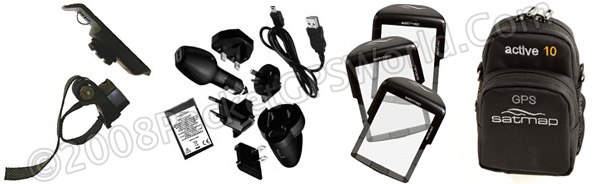
Accessories including bike mounts, a lithium polymer battery and charger set, spare screen covers and cases are available.
Technical Specification
| CPU: |
ARM 9 |
| Screen: |
3.5" LCD TFT |
| Built-In Memory: |
128MB RAM |
| SD Card Reader: |
Expandable up to 4GB |
| Memory Card: |
SD Slot, no memory card supplied |
| GPS Receiver: |
Integrated SiRFStarIII Receiver |
| Compass: |
Built-in 2 Axis electronic compass |
| Sound: |
High Quality Speaker |
| Power Supply : |
3 x AA Alkaline batteries
3.7v 2700mAh lithium Polymer 'smart' battery
240v/120v mains supply
12v DC vehicle cigarette lighter |
| Weight: |
250g (inc 3 x AA's) |
| PC Connection: |
Via mini-USB cable (supplied) |
Conclusion
When initially launched, Satmap's Active 10 had many bugs, some very irritating. It is testament to Satmap that the majority of the bugs that were present have now been resolved and better still, features that were suggested by the early adopters and modifications to the user interface have been implemented.
Nothing else on the market offers the experience that you get from the Active 10. The nearest you would get is a PocketPC running Memory-Map but you would need to add a bulky waterproof case and additional batteries and even then it would not be operable whilst gloved nor would it be as easy to use.
There are a few issues still present in the software but in the short time it has been available Satmap have worked very hard to resolve them and it is already a much better and more stable device than it once was. I would like to see an on screen heading vector, one that clearly shows your current direction overlaid on the map, many other topographical packages offer this and it is the one feature I did miss on the Active 10 but it's a small omission that could easily be rectified in software.
If you are in the market for a rugged outdoor GPS that also has the huge benefit of full colour digital OS mapping then this has to be the only option worthy of consideration.
Pros
- PC free design.
- Robust construction.
- Bright screen, easily visible in strong sunlight.
- Very easy to use.
- Excellent logging options.
- Electronic compass.
|
|
Cons
- LiPo battery should be standard.
- Joystick movement disables GPS mode, reverting to Planning mode.
- Sometimes slow to acquire first fix.
- Mac compatible SatSYNC software not yet available.
- No anti-theft measures.
|

|