|
|
 |
 |
 |
 |
| Route66 Mobile Britain 2005 for Nokia Series 60 phones review |
15th October 2004 |
|
Review by Mike Barrett
Way back in January I reviewed the first full navigation system for mobile phones Wayfinder. At the time I wrote:
"All in all I think that 2004 will be the year of mobile technologies. Wayfinder
is the first of a new breed which will broaden the use and functionality of
portable navigation systems."
I think I have been proven to be correct. A whole raft of GPS enabled applications is hitting the market now. With the mobile phone market being much larger than the PDA market there is a massive opportunity for the company that gets it right.
Route 66 is a well known producer of navigational products, first on the PC, then on PDAs and now it is the first company to offer a complete on-board mobile phone navigation system.
Known as Mobile Britain 2005 this was first launched in the UK with maps of UK and Ireland, and later a second product Mobile Athens was released to coincide with the Olympic Games. |

|
| Overview |
The Route 66 Mobile Britain is
a complete navigation package for a Symbian mobile phone.
This comes as a pre-installed MMC storage card for your phone
and a Bluetooth GPS receiver. All you do is insert the card,
switch on and prepare to navigate.
The Route 66 Mobile Britain is a fully featured navigation
system incorporating voice navigation, routing and guidance
to your selected destination, automatic re-routing and TMC
traffic data.
To help you select your destination the package includes
many thousands of points of interest ranging from petrol
stations to tourist attractions.
Route 66 Mobile Britain is an on-board navigation system.
That means that the entire maps and application etc are all
on the mobile phone. The system will work even when you do
not have a phone signal.
|
 |
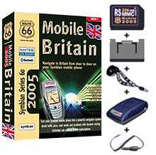
| What's in the box |
Route 66 Mobile Britain 2005
comes in a large box, fortunately most of which is empty.
The box contains:
- A 256Mb RS MMC card containing the application and map
data. (RS stands for Reduced Size)
- An adapter to convert the RS MMC to a full sized MMC
card.
- A RoyalTek RBT-1000 Bluetooth GPS receiver.
- A neck lanyard for the GPS receiver.
- A cigar lighter power supply adapter.
|
 |
| Manufacturers Specifications |
- Navigate in Britain from door
to door on your Symbian mobile phone
- The first onboard navigation solution for Symbian mobile
phone
- Complete navigation kit for Symbian mobile phone
- Turn-by-turn voice instructions and on-screen directions
- Language(s) of user interface and voice instructions: British-English,
French, German, Italian, Spanish and Dutch
- Address search engine with SMS-like text input
- Direct dialling to points-of-interest
- Professional geographic data from leading in-car navigation
manufacturers
- Geographic coverage: Great Britain
- More than 250,000 miles of road
- More than 14,500,000 house numbers
- More than 70,000 points-of-interest
- Add your personal contacts as waypoints to your route
- Avoid traffic jams, road works and accidents with dynamic
routing via GPRS in Great Britain
- Fly like a bird over your route
- Keep a clear view on the road at night with night colours
- Unlimited use without further subscriptions
- Plug & Play installation
|
| Compatibility |
The software package is designed
to work with any phone that is based on the Nokia Series
60 platform which has Bluetooth connectivity. This is currently:
- Nokia 6600 (the phone used in this review)
- Nokia N-Gage
- Nokia 6260
- Nokia 6620
- Nokia 6630
- Nokia 7610
- Sendo X
- Siemens SX1
This list was supplied by Route 66.
|
 |
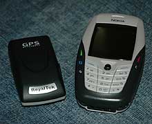
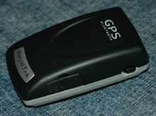
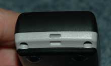
| RoyalTek Bluetooth GPS Receiver |
The hardware supplied with the
Route 66 Mobile Britain bundle is the RoyalTek RBT-1000.
This is the latest Bluetooth GPS receiver from RoyalTek and
is one of the smallest GPS devices that I have seen.
The GPS features a secure On/Off switch, which is a real
benefit as it is virtually impossible to switch it on accidentally.
There is a MCX socket to allow the connection of an external
GPS antenna. Finally there is a slot to attach the neck lanyard
to.
As with most GPS devices today the RoyalTek RBT-1000 has
increased positional accuracy using SBAS. This can be either
WAAS or Egnos.
According to RoyalTek the GPS receiver also has the latest
SiRF Xtrac 2.0 software installed. I did notice that the
receiver was quite sensitive, but I never noticed any lag
or running on that has been associated with previous versions
of Xtrac.
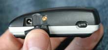
The socket for the power connector is hidden under a rubber
flap, and is of the same size and type as those commonly
found on PDAs, but is not compatible with your mobile phone
charger. This is a bit of a shame as it means the the GPS
can only be charged in the car.
The GPS has an inbuilt battery, which can be replaced
by the user. The battery life of the GPS tested to be over 7
hours from a full charge. Of course whilst driving the GPS
can be powered using the cigar lighter adapter extending
the usability period.
The GPS will far outlast
the mobile phone if neither units are being powered externally,
so battery life should not be an issue. It would have been
useful for the bundle to include a mains power supply to
enable the GPS to be charged at home or in the office as
opposed to having to rely on charging whilst travelling
in your car. |
|
| Mapping Data |
The mapping data supplied with
the software is provided by NAVTEQ. Having recently visited
the UK NAVTEQ office and seeing how their data is compiled
I am impressed with it's accuracy.
As far as the currency is concerned the maps provided are
from the Q1 2004 NAVTEQ release. This includes the M6 toll road
which is missing on some products. It also includes the lower
section of the A130 between the A129 and the A127. This is
the second mass market product to contain the lower section,
both have been released in the last couple of months.
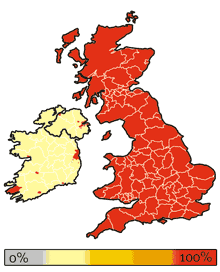
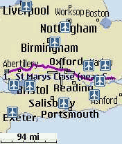
The maps provided include both UK and Ireland. The image
to the right shows the coverage provided by the maps. The
UK has full coverage, but Ireland is less fortunate. Dublin
and Belfast have full street level coverage, so has parts
of Kerry and a couple of other towns, but the bulk of Ireland
only has major roads in the data. The Channel Islands are
also included as are the Scilly Isles. So this really is
good coverage of the UK.
The accuracy of the NAVTEQ data is very good and they tell
us that only include roads that they have physically driven.
They only use 3rd party data to plan where they need to survey.
This means that all the roads in the maps are genuine and
driveable.
|
 |
| The Route 66 Mobile 2005 Software |
Ok so the previous sections have described
the components of the bundle and the quality of the map data
supplied but what is the application like to use?
Route 66 Mobile Britain is a full featured, on-board navigation
system. All the maps for the UK and Ireland are provided
together with the application on a 256 MMC card. It is a
simple plug and play system.
The software is actually supplied on a RS MMC card which
is half the size of a normal card. A number of mobile phones
are being produced now that take memory in this form factor.
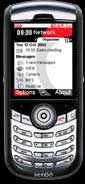
I was using a Nokia 6600 which uses a full sized MMC card.
This is not a problem as the bundle includes an adapter to
convert the card. It should be noted that the Nokia 6600
only uses MMC cards, you physically cannot insert an SD card
into the phone. Believe me I tried and tried and tried. I
just doesn't fit.
|
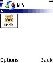 |
The GPS software really is Plug and Play. You
simply insert the card and the application is installed. Select
the Route 66 icon from the program menu and the Mobile Britain
splash screen is displayed whilst the application loads.
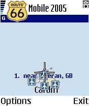
You are then presented with a fully zoomed out map of the
UK and Ireland as shown to the right.
The application
will then start looking for GPS devices. As this is the first
time you have started Route 66 you will be asked to select
a Bluetooth GPS receiver from a list of discovered devices.
Having selected one you will be asked if you want it to be
the default for next time, if you accept it will connect
automatically next time.
The software is not tied to any specific receiver and has
worked with a number of GPS receivers that I have tried. |
 |
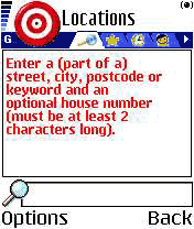
So now you are ready to choose a destination.
Pressing the left button will display the menu. Select start
then you will be shown the screen to the right.
Destination selection provides you with a number of choices:
- Searchable
- Favourites
- Points of Interest
- Recent searches
- Contacts
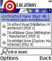
One nice feature of the search is that you can put as much
of an address in as you need. I initially took this to mean
the road name and the town, but this is not the case. Searching
through the points of interest I put in "Stra Man" and Mobile
Britain managed to find "The Stratford Manor Hotel".
|
 |
You only need to provide enough letters for
the search engine to make a reasonable match. This is a great
feature for me as I have terrible trouble inputting text on
phones, I am definitely not a "text" person.
Having found the correct destination you select
the Navigate to option and this calculates a route from
the GPS position to your journeys end.
As you start to drive the route the map is updated constantly
to show your precise position. If you deviate from the planned
route then it will recalculate the route to ensure you arrive
at your selected destination.
Once your destination has been set it is almost impossible
to go wrong (he says with a smile  ). ).
|
 |
| TMC Traffic Information |
As all the maps are stored on the memory card
on the phone there are no additional costs or overheads for
normal navigation. Having said that there are the value added
services of traffic information, which connects to the internet
via GPRS to download information about road conditions.
The traffic condition data for the UK is TMC data provided over a GPRS connection and is provided
by ITIS in the UK, and other providers for other countries (not covered here).
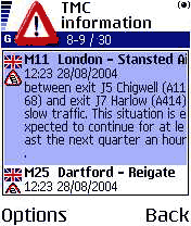
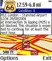
In this particular example shown on the right there are
some incidents shown as UK traffic jams, one on the M11 near
the M25 junction and the other on the M25 after the Dartford
Tunnel.
You can select the incident and then display it on a detailed
map. |
 |
On the detailed map an icon is displayed depicting the type
of incident. In this case the exit slip road is blocked. The
map clearly shows the problem with an associated description.
So knowing that the motorway is blocked is good, but not of
much use on it's own. Route 66 has the intelligence built in
to route around these blockages and delays.
The usefulness of this facility is very dependant on the quality
of the traffic data. This accuracy has been questioned by users
of other applications using the same traffic data. The jury is
out at the moment until we have more information, but any
data is better than none at all.
Some of the re-routing has been interesting to say the least.
I was once taken off a motorway, sent 1 mile down the road,
performed a u-turn and re-joined the motorway at exactly the
same point I had left it.
|
 |
| The Route 66 Mobile Britain
Screen Displays |
Now one area of controversy in
the mobile navigation industry is the display of map data
and safety screens, and navigation instructions. This is
discussed in the forums, and amongst suppliers and safety
specialists.
One argument is that
you should not need to touch or even look at a screen whilst
driving. The voice guidance should be sufficient to determine
where you should make your manoeuvres.
The other camp suggests that you should not blindly follow
the instructions, but you should be able to look at a screen
that has clear visibility of where you are and where you
want to get to which can back up the audible instructions.
On a PDA that can often be a challenge, but on a mobile
phone with a display area of 35mm by 45mm that can be virtually
impossible.
The 3 images below show three of the different views available
taken from the same position. From left to right:
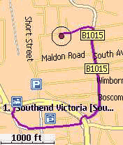
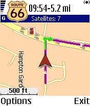
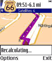
- Normal 2 dimensional map view. Here you can clearly see
the route highlighted in purple, the next turn shown in
green and your current position shown as a red arrowhead.
Above the map is an information area showing the strength
of the satellite fix, and the estimated driving time and
distance to go.
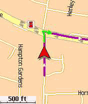
- The second image is a full screen image. All of the information
at the top has been lost as have the prompts for options
and exit.
- The last screen shows a 3D representation of the map.
This includes the same information items as the 2D display.
There is also a full screen version of this display.
|
   |
In addition to the above displays
there are also the following (again from left to right):
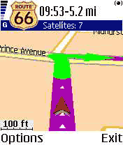
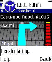
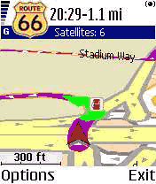
- A "next turn" display. This features a bar down the right
hand side giving an indication of the distance to the turn.
When it is yellow you are some distance away, as you get
closer the bar turns red, until you make the turn. In this
instance I was using my local knowledge and ignored the
turn instruction knowing that I would be quicker. Mobile
Britain recalculated and took my preferred route.
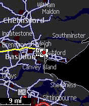
- An overall map of a journey planned from Essex to Wales.
- The night screen. Some people like to have a screen with
a different, less bright, colour scheme when driving at
night. This reduces glare and can improve night vision.
|
   |
| Detailed Software Features |
|
The previous sections provided an overview of
the Route 66 Mobile Britain software these sections look at
the features in a bit more detail.
Starting with the controls there are two main buttons: the
options menu button and the joystick button. Both of these
buttons initiate a different set of functions.
When you have
a menu selection available you can navigate through it
either by using the joystick and the joystick button, or
in most cases by keying the number associated with the option.
Some of the options described below will only be available
within context. For instance you will only get GPS related
functions when you have a GPS Fix.
|
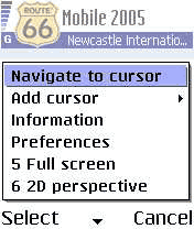
Joystick Button
The Joystick button controls functions associated with the cursor. The joystick moves the cursor around the display whilst the "action button" pops up a context sensitive menu.
From the menu you can:
- Navigate to the cursor position
- Add the position to either the route as a waypoint, or to your favourites.
- Show information
- Change your preferences
- Switch between normal and full screen modes
- Switch between 2D and 3D modes.
Navigate to Cursor position.
This option creates a route from your current GPS position to the cursor position. If you do not have a current fix then the route will be calculated when a fix is obtained.
Add Cursor Position to Waypoints
When you use this option the cursor position is added to the route that you are planning. The position is added to the end of the list. This makes it possible to plan a route for multiple drop-offs.
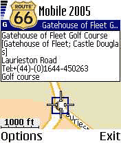
Show Information
This option allows you to see additional information related to a POI, road or other item on the map. This pops up a small panel containing the data. If you have selected a POI then additional information is supplied, including a phone number if applicable.
Change Preferences
This option allows you to change the way the application works. These options are described below.
Select Full screen
This option allows you to select between full screen and normal screen.
Switch between 2D and 3D
This allows you to select the way the map is displayed on the screen. Self explanatory.
|
|
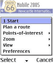
The Options menu button.
The options menu button on the Nokia 6600 is situated to the left of the joystick. This provides access to the functionality described below:
- Start
- Plan a route
- Points of Interest
- Zoom
- View
- Preferences
Start
The start option provides a method to navigate from the GPS position directly to an end point. This can be either an entered location, a favourite, a recently visited location or a person in your contacts database.
Plan a Route
When you select Plan a Route you are presented with an empty list. You can then add waypoints based on entered location, favourite, recent location, or contact. This builds up your trip itinerary. You can then navigate the selected route.
As mentioned above the search is very powerful, enabling a location to be found with a minimum of entered data. The image to the right shows how I found the Stratford Manor hotel.
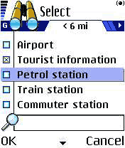
Points of Interest
The POI option allows you to find POIs either around the cursor location or your current GPS position or your destination.
You can select POIs from a list of POI categories. They can then be further refined by selecting within a radius of the location. This makes it easy to find all petrol stations within a radius of 6 miles, etc.
Zoom
With zoom you can select to zoom to: the GPS position, the entire map, in (short cut '*') or out (short cut '#'). Zoom to route, and zoom to destination are only available when you have a route set.
View
You can use view to select the primary display on the screen the options available are: Turn Arrows; GPS information; TMC information; the map legend and the about screen.
|
|
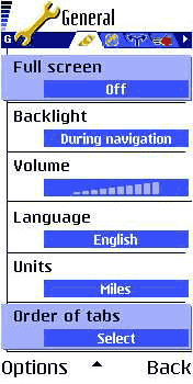
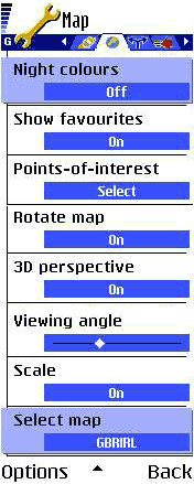
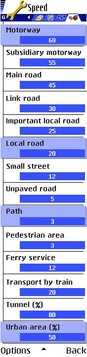
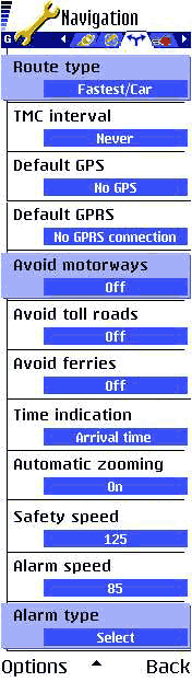
Preferences
When it comes to preferences Route 66 is second to none. It even beats most PDA and PC navigation packages for configurability.
The preferences come in lists grouped in four categories: General, Map, Speed and Navigation. Most of the options are self explanatory so I will just list them here.
General
Full Screen, Backlight, Volume, Language, Units
Map
Night colours, Show Favourites, Show POIs, Rotate Map, 3D on/off, 3D viewing angle, scale, select map
Navigation
Type (fastest car/shortest car/fastest lorry/shortest lorry/pedestrian), TMC Interval (never/10/20/30 mins), Default GPS, Default GPRS, Avoid Motorways, Avoid tolls, Avoid ferries, Time indication (arrival/travel), Auto zooming (on/off), safety speed, alarm speed, alarm type (audible/visual)
Speed
road class speeds, ferry, train, tunnel %, urban %
|
 |
   |
Route66 Mobile Britain in use
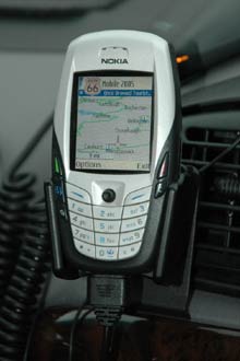 The first thing to consider is where to position the phone and GPS. The GPS is not an issue as it is Bluetooth it can be placed just about anywhere in the car where it can see the sky. This is good for cars with coated windscreens as it means that the GPS can be placed on the rear parcel shelf and still work. The first thing to consider is where to position the phone and GPS. The GPS is not an issue as it is Bluetooth it can be placed just about anywhere in the car where it can see the sky. This is good for cars with coated windscreens as it means that the GPS can be placed on the rear parcel shelf and still work.
The main problem is what to do with the phone. I used a Brodit mount for mine which I have attached to my all purpose mounting system using the Brodit Move Clips, a clever little system that uses double sided tape to attach securely to a flat surface.
The picture to the right shows my setup in the car. As you can see the phone will be at arms length from my eyes, meaning the map detail will be pretty small. This means that you have to rely on the voice instructions and the turn indicators.
Now the Nokia 6600 is a good little phone, but the output from it's speaker is somewhat limited. There is also an issue with battery life. I got round both these problems by using a hands free car kit. The one I use is a Mr Handsfree Carkit Pro, this is functional in use it is a bit fiddly, and the power connection is less than reliable. That said it does the job, and of course, operates as a hands free car phone as well.
Before getting into the application I will answer the question that everyone asks: "What happens when the phone rings?". Route66 is suspended and the phone is activated. You can have a normal handsfree conversation on the phone and then when you hang up Route66 comes back into action again. Whilst Route66 is suspended and you are in the phone conversation all voice prompts are suppressed so you could "come a cropper" if you get a call whilst making a series of intricate turns.
It took me a little while to get used to the user interface. That is not a criticism of the interface, probably more of my ability to use the phone. I am not one of the people who send text messages at the speed of light. I have only just mastered a computer keyboard!
The selection of a destination and the ability to input waypoints was really good. Most PDA navigation systems do not allow for route planning with multiple stops. The routes selected seemed under most circumstances to be good and accurate. In all cases they sent me to the correct destination, not always by the route I would have chosen, but then the software doesn't have my local knowledge. This is one thing that you must always allow for with a navigation product: the calculated routes will get you there, but not always in the way you would route.
If you deviated from the planned route then Route66 detected the change of direction and after a short period recalculated a new route. Taking you back on track to your destination. My perception was that the routing and re-routing took quite a time, but this was compared to PDA times. When more Mobile Phone systems are available we will do a comparative test of both functionality and speed.
|
| Issues and Problems |
Whilst I was testing the software a few issues arose, the worst of which has been fixed in the latest version of the software.
The early version of software I used had some random crashes causing the software to die completely. This was great fun as I had to tell my wife how to set the route up again from memory, and she doesn't know how to operate the phone. The latest version of the Route66 Mobile Britain has cleared this problem up.
I also experienced a number of routing issues. The images to the right highlight a couple of the problems encountered.
The picture at the top shows a route created between Southend Airport and the Bell Pub on the A127. The route created tried to take me off the main road,down a service road and then back onto the main road again. This is actually consistent with other mapping products.
The lower picture shows an even stranger routing where I am heading up the A129 between Rayleigh and Hadleigh. The route created takes me off the A129 through a shopping centre then back onto the A129, shortly after it takes me off the A129 and through a series of residential roads. This seemed to be trying to avoid the A129 for some reason.
There was a problem with either the alarm speed or the safety speed. This resulted in the screen being blanked and no voice instructions issued until I dropped below the safety speed. This is not very effective as directions were not given when exiting the Motorway.
|
|
|
| Conclusions |
|
The pedigree of Route 66 certainly shows in this product. The user interface and operation far surpasses that of the PDA version and is much easier to use.
This is an amazing product for such a small package. The GPS is small and compact perfectly complementing the dimensions of the phone.
The mapping detail is some of the best coverage I have seen in any application, and is also very up to date (in my area). It is easy to find an address or location using some smart search technology.
All in all for the first "on-board" mobile phone navigation system this is a big thumbs up. |
Pros
- Plug and Play installation
- Map Coverage
- Currency of maps
- Configuration options
- Integrated traffic information
- Compact GPS receiver
|
Cons
- Routing seemed a bit "interesting" at times
- The Safety speed / alarm speed did not work as expected
- Phone has a limited battery life
- Screen is too small to read maps whilst navigating.
|
|
|
|
 |
 |
 |
 |
|
|


