|
http://www.oziexplorer.com
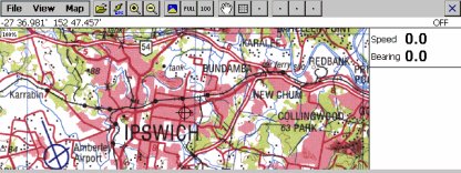
OziExplorerCE is moving map software for
Window CE devices, it uses raster map images which are either scanned or
purchased in digital format.
OziExplorerCE is
not automatic route planning software,
you cannot request the best way to get from point A to point B, if you
require this type of software then OziExplorerCE is not for you.
OziExplorerCE will not be available for Palm Pilots or any other operating
system.
The design philosophy is you plan your trip
using the full PC OziExplorer on you PC and then transfer your waypoints
and other data to your CE device for use by OziExplorerCE.
OziExplorerCE runs on a Windows CE device but it relies on map
calibrations etc to be provided by the full PC version of OziExplorer, in
the respect OziExplorerCE can be considered an add-on to the full
Oziexplorer software, you also need the full OziExplorer to calibrate
maps, plan trips by adding waypoints etc.
System Requirements
These are the types of devices supported.
-
Handheld - HPC (CE version 2) , HPC Pro
(CE Versions 2.11,2.12) and HPC 2000 (CE version 3.0+)
-
Palm sized - PPC (CE version 2.0 and
versions 2.11,2.12)
-
PocketPC - PC2000 (CE version 3.0+) ,
PC2002 (CE version 3.0+)
ARM , MIPS , SH3
and SH4 cpu's are supported for all platforms where applicable.
Gps Requirements
-
For real time
navigation almost any GPS receiver with NMEA 0183 output of the GPRMC or
GGA or GLL sentence.
-
For
upload/download of data (when available) selected models of Garmin
Lowrance/Eagle or Magellan's.
-
A cable to
connect the standard CE device serial cable to the standard GPS serial
cable is required. A diagram of how to wire this cable is in the help
document.
Map Requirements
-
Maps of your
particular area of the world which you can scan or purchased digital
maps in the correct format.
-
All maps must be
converted to the ozf or ozf2 format, a
conversion utility will be supplied. The ozf / ozf2
format is a special format developed for use in OziExplorerCE (details
are in the help document). The format allows paging of the image from
disk and therefore requires little memory for image display.
-
Note - No
useable maps are provided with this package only example maps.
Features
-
Moving map
navigation using any GPS providing NMEA output in one of the supported
sentences.
-
Automatic
loading of the next map.
-
Automatic Route
prompting (voice and symbol).
-
Create Route on
screen.
-
Check for more
detailed map at 30s intervals.
-
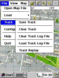
Logging of Track
points to file.
-
Display of track
on screen
-
Replay of stored
tracks
-
Create Waypoint
at current position
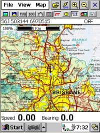
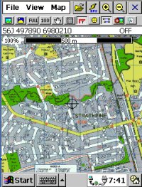
-
Many Map Zoom
levels
-
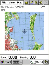
Various Position
display formats
-
On screen
display of Speed and Bearing
-
Speed Monitor
(plays sounds (wav files) when set speeds exceeded).
-
Display
Waypoints on the map
-
Find Maps at
cursor position
-
Uses and writes
files in the same formats as the full PC based OziExplorer
-
Name Search
-
Satellite View
-
Map View
Vector Maps
OziExplorerCE does
not support vector maps and most likely never will.
|