|
Article by
Scott Krotz for Pocket GPS
The Navman GPS 3420
package comes with the Navman sleeve, a suction cup mount, an auto power
adaptor, and the SmartST Professional navigation software on 2 CDs.
It only includes a couple page getting started guide in terms of hardcopy
documentation. The auto adaptor doesn't include the connector, you need to
hook it up to the iPAQ, strangely enough. Not a huge deal, but it seemed
odd to me.
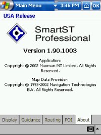
The CD's are split up into western and eastern US. The CD contains
the SmartST Professional software installer, map installation software, an
iPAQ 3600 series ROM upgrade (I think), a quick start guide, the user
manual, and a link to Navman for software updates. The map data is from
Navtech, and seems pretty complete and
recent.
I first installed the software to my storage card, which was a bad idea,
because it didn't work. It gave me an error about not being
able to find the speech sound files. I re-installed to main memory, and it
worked. I checked, but I couldn't find anything in any of the
manuals that said it couldn't be installed to storage card. I then
installed the map data, which is split up into large "zones," about 24 for
the entire US, and they average approx 30 megabytes per zone. Some are
smaller, some larger, depending on the area. I installed zone 11
(northern California and northern Nevada) and zone 12 (southern California
and the southern tip of Nevada). It took a long time to install the
maps, as for some reason it writes them very slowly. It tells you
the rate of install after it finishes, and I averaged 40k/sec! Strange.
This was to install to a 128meg SD card.
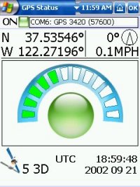
I started up the software, and it comes up to basically a blank screen
telling you its looking for a GPS signal. The cold start took so
long that at first the iPAQ turned itself off because it was on battery.
Kind of annoying. I set the iPAQ to not turn off when on battery
power, and restarted the software. After a few minutes it found a
signal and showed me my position. The software evidently has a lock
to road feature, because it jumped from my actual position where my
apartment is to the nearest road. To control the software you use a
combination of the touch screen and the directional pad. Pressing
left goes to the main menu, where it turns out you can bring up a GPS
info screen instead of looking at the blank "waiting for gps" screen.
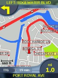
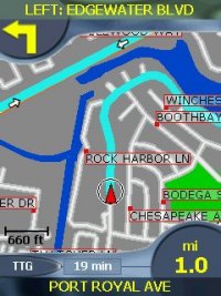
Pressing up zooms the map in, pressing down zooms out, and
pressing right toggles between the map screen and a text direction
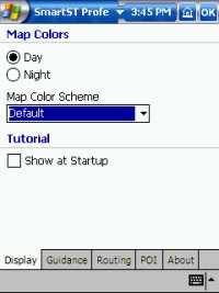
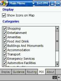
screen. There are a few selectable map drawing schemes, and there is
also a day and night mode, but you have to manually select it, it doesn't
do it automatically based on the current time like a Streetpilot III does.
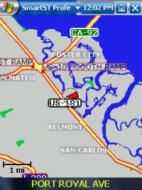
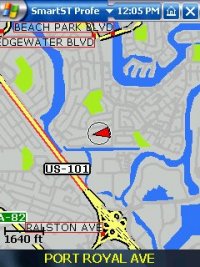
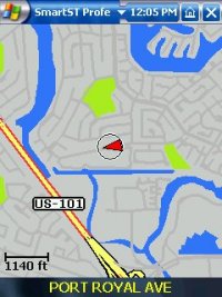
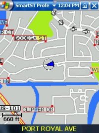
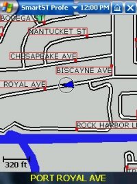
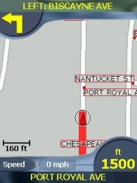
The map rendering seems very good, possibly the best of any Pocket PC
software I have seen. The maps are crisp and detailed, even
including showing roads that are separated by dividers, arrows indicating
one way streets, and attractive labels and symbols for roads and POI's.
You can move the map around by "sliding" it similar to
Mapopolis. It redraws very
quickly after being moved, even if zoomed out quite a bit.
Identifying the name of a street is a little tricky because of the way it
shows them, but once I got used to it it isn't too bad. To show your
position on the map it uses a little arrow with a circle around it
indicating your heading and the current accuracy in exactly the same way
the Garmin Streetpilot III does.
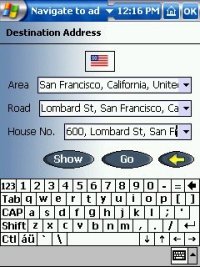
To find a destination, you can enter it in by address, intersection, point
of interest, favourites, or recent destinations. When entering
information in, you can enter in partial info and after a second or so it
will show you a list of potential matches that you can select from. This
didn't work until I clicked on the little US flag that was at the top of
all the destination screens. I think to select my country.
Presumably European versions would have flags for all the countries you
have map data loaded for. Once selected, the country stayed selected so I
haven't had to click it since. It also a little confusing in that
when it says "area" it seems to really mean "city" in the destination
selection screens.
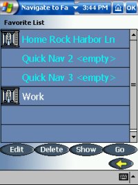
You can save several destinations in your favourites, I'm not sure of the
maximum. Three of your favourites can be designated as "quick nav"
points, which are accessible from the quick nav tab in the main menu.
Its a little tricky changing a favourite into a quick nav point, I had to
look in the manual to figure it out. Its also a little strange
setting favourite destinations, in that there is no way to directly enter
in an address and save it as a favourite, but you can do it easily enough.
Once you select a destination, it calculates the route. It shows the
progress of the route calculation, which takes a few seconds for a short
route, up to several seconds more for a longer route. It wasn't
blazingly fast, but it wasn't tragically slow either. There doesn't
seem to be any issues about loading zones, as I was able to route
between zones and jump between map positions in different zones with
ease. It seems to stitch zones together in the same way the
Streetpilot III does into one big zone.
The zones are very large
in any case. There doesn't seem to be an underlying "base map," so
you can't route to anywhere that you haven't loaded contiguous map data
for, it seems. I'm guessing that cross country routes are possible,
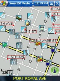
but you'd need to load a lot of map data. The available POI's are
decent, but not to the level of the Streetpilot III.
The POI's don't show up on
the map unless you are fairly zoomed in, except for certain things like
airports. Annoyingly, sometimes the icons seem to "stack up" on each
other, so you don't know that a POI is present because it is "underneath"
another POI.
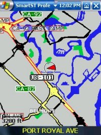
Once you have a route calculated you can press right to toggle
between the following screens:
-
a map view
-
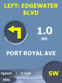
a map view with some text about your next
turn/speed/distance to next turn and the road you are on, as well as an
arrow indicating the next manuever (no map at all on this screen)
-
- a screen with text indicating the next
turn, distance to next turn, the road you are on, the current time, your
current speed, and your current ETA, as well as an arrow indicating the
next manuever.
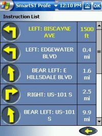
You can also go to the
main menu and bring up a list of text directions, an "instruction list."
Some of the items on the various screens can be changed into other info,
such as the total distance to go, the total time to go, and your current
heading. Its actually quite nice. The layout of the screens is nice and
the graphics are clean and crisp, the best I have seen I would say.
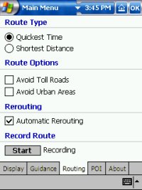
You can select a few routing options in the setup screen including
quickest time, shortest distance, avoid toll roads, and avoid urban areas.
You can also switch on/off the automatic rerouting. There is an option to
record a route as well. I did some test routes and they seemed good,
no bizarre routes or illegal turns.
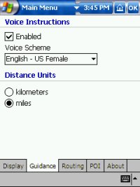
The voice commands are a little fuzzy, but seem quite understandable and
are well spoken. You can select between a male and female voice.
You can select a volume level that will override your current volume
settings, and this is saved so that every time you run the program the
volume gets set to that level. It doesn't remember to un-set it when
you leave the program, though.
The voice commands are
pre-recorded, not synthesized so it doesn't say street names.
Touching the arrow symbol on any of the various screens makes it re-say
the current directions, which is handy.
Overall the interface is nice, but not completely intuitive. Most
things seemed designed to be easy to use with a finger instead of a
stylus, which is nice. Only data entry really requires a stylus, and
even that could be done with a finger if you set the keyboard to large
keys, as they recommend in the manual.
The software overall seems pretty good, although it looks like a beta
copy. Its a bug fix revision or two away from being truly solid, but
hopefully Navman will continue to update the software. With some bug
fixes and a few minor features, it could potentially be among the best
Pocket PC GPS Navigation Software. |
Navigation Screen
Turn by Turn Navigation
Screen
Map and Navigation
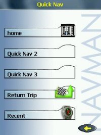
Quick Nav Menu
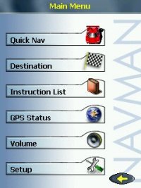
Main Menu
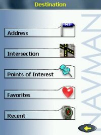
Destination Menu
|