MikeB
Frequent Visitor

Joined: 20/08/2002 11:51:57
Posts: 3859
Location: Essex, UK
|
 Posted: Mon Apr 13, 2009 7:13 pm Post subject: Garmin Oregon 500 leaked on resellers sites Posted: Mon Apr 13, 2009 7:13 pm Post subject: Garmin Oregon 500 leaked on resellers sites |
 |
|
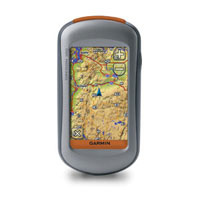 Today has seen a flood of speculation about a new Garmin Oregon 500 which seems to have originated in a reseller's printed pricelist, but has since appeared on the Handtec website. Today has seen a flood of speculation about a new Garmin Oregon 500 which seems to have originated in a reseller's printed pricelist, but has since appeared on the Handtec website.
Looking at the specifications published (see below) this seems to be basically similar to the current Oregon range with the exception of a digital camera, though the specifications of the camera are not included in the listing and indeed the listing looks like the Oregon 400 with appropriate name changes. So it remains to be seen how accurate they are.
They are advertising 2 models a 500 and a 500t the difference being that the 500 comes with a basemap and the 500t comes with topographcial maps. Pricing is £354 for the 500 and £402 for the 500t.
The following is an extract from the Handtec website product page:
The Garmin Oregon adds in a digital camera that for automatic picture geotagging.
Get in touch with your wild side with Oregon 550t. This next-generation handheld features a rugged, touchscreen along with preloaded topographic maps, 3D map view, a high-sensitivity receiver, barometric altimeter, electronic compass, microSD card slot, picture viewer and more. Even exchange tracks, waypoints, routes and geocaches wirelessly between similar units.
Touch and Go
Garmin Oregon 550t leads the way with a tough, 3-inch diagonal, sunlight-readable, colour, touchscreen display. Its easy-to-use interface means youll spend more time enjoying the outdoors and less time searching for information. Both durable and waterproof, Oregon 550t is built to withstand the elements. Bumps, dust, dirt, humidity and water are no match for this rugged navigator.
Explore Backcountry in 3-D
Garmin Oregon 550t's preloaded European topographic map*, 3D map view and a built-in worldwide basemap with shaded relief give you all the tools for serious climbing or hiking. Map detail is simple and easy to read, and includes terrain contours at 100m intervals, land use information, rivers, lakes and street-level detail for 29 countries across Europe**. And, just in case youre wondering how steep that hill really is, Oregons 3D map view helps you visualise your surroundings giving you a better perspective of the elevation.
Share Wirelessly
With Oregon 550t, you can share your waypoints, tracks, routes and geocaches wirelessly with other Oregon and Colorado users. Now you can send your favourite hike to your friend to enjoy or the location of a cache to find. Sharing data is easy. Just touch send to transfer your information to similar units.
Find Fun
Oregon 550t supports Geocaching.com GPX files for downloading geocaches and details straight to your unit. No more manually entering coordinates and paper print-outs! Simply upload the GPX file to your unit and start hunting for caches. Show off photos of your excursions with Oregons picture viewer. Slim and lightweight, Oregon is the perfect companion for all your outdoor pursuits.
Keep Your Fix
With its high-sensitivity, WAAS-enabled GPS receiver and HotFix satellite prediction, Oregon 550t locates your position quickly and precisely and maintains its GPS location even in heavy cover and deep canyons. The advantage is clear whether youre in deep woods or near tall buildings and trees, you can count on Oregon to help you find your way when you need it the most.
Get Your Bearings
Garmin Oregon 550t has a built-in electronic compass that provides bearing information even while you're standing still, and its barometric altimeter tracks changes in pressure to pinpoint your precise altitude. You can even use the altimeter to plot barometric pressure over time, which can help you keep an eye on changing weather conditions.
Add Maps
Conveniently plug in optional preloaded microSD cards for all your outdoor activities on land or water (see maps tab for compatible maps). Just insert a MapSource® card with detailed street maps, and Oregon provides turn-by-turn directions to your destination. Add detailed trail information by purchasing optional TOPO maps for national parks and more. With BlueChart® g2 Vision, youll get everything you need for a great day on the water including depth contours, navaids and harbours. The card slot is located inside the waterproof battery compartment, so you don't have to worry about getting it wet.
Garmin Oregon 550t: Touch the great outdoors.
Specification:
Physical & Performance:
Unit dimensions, WxHxD:2.3" x 4.5" x 1.4" (5.8 x 11.4 x 3.5 cm)
Display size, WxH:1.53"W x 2.55"H (3.8 x 6.3 cm); 3" diag (7.6 cm)
Display resolution, WxH:240 x 400 pixels
Display type:Transflective color TFT touchscreen
Weight:6.8 oz (192.7 g) with batteries
Battery:2 AA batteries (not included); NiMH or Lithium recommended
Battery life:16 hours
Waterproof:yes (IPX7)
Floats:no
High-sensitivity receiver:yes
PC interface:USB
RoHS version available:yes
Maps & Memory:
Basemap:yes
Preloaded maps:yes (topographic)
Ability to add maps:yes
Built-in memory:yes
Accepts data cards:microSD card (not included)
Waypoints/favorites/locations:1000
Routes:50
Track log:10,000 points, 20 saved tracks
Features:
Automatic routing (turn by turn routing on roads):yes (with optional mapping for detailed roads)
Electronic compass:yes
Barometric altimeter:yes
Geocaching mode:yes (paperless)
Outdoor GPS games:yes
Hunt/fish calendar:yes
Sun and moon information:yes
Tide tables:yes
Area calculation:yes
Custom POIs (ability to add additional points of interest):yes
Unit-to-unit transfer (shares data wirelessly with similar units):yes
Picture viewer:yes
Additional:
Touchscreen: yes
What's in the Box:
Garmin Oregon 550t
Carabiner clip
USB cable
Owner's manual
Quick start guide
_________________
Mike Barrett |
|


