| View previous topic :: View next topic |
| Author |
Message |
Colonelgrey
Occasional Visitor

Joined: May 15, 2006
Posts: 8
|
 Posted: Thu May 22, 2008 8:24 pm Post subject: Heathrow Airport??? Posted: Thu May 22, 2008 8:24 pm Post subject: Heathrow Airport??? |
 |
|
I've just bought & installed the latest version UK & Ireland map for my original TT500. Everything has gone as planned, my warnings are fine etc etc! However, one problem persists. When I plan a route, the software ALWAYS avoids entering the airport. For example, if I plan a route from one side of the airport to the other, the shortest route calculated is always the long way around when it plainly is not. I have planned using the fastest route option, the shortest and the rest but the results are always the same. Can anyone explain why? Thanks in advance!!!
PS: - Is there a POI download that states the names of tube stations and railway stations instead of just an icon? Ta! |
|
| Back to top |
|
 |
DennisN
Tired Old Man


Joined: Feb 27, 2006
Posts: 14892
Location: Keynsham
|
| Posted: Thu May 22, 2008 8:44 pm Post subject: |
|
|
Are the roads which you would like to travel along marked with coloured dashes? That means they are non public access (or maybe non through route) roads. As a test, navigate to Point on Map and select a point in the middle of the airport on one of the roads you think you should be able to navigate along and the 500 WILL navigate to it. Another test is again to try to navigate across, but after you get the long way round version, tap Find Alternative, select Travel Via and Point on Map and select a mid airport point.
I don't think you'll get a POI download for tubes/station which displays the name instead of just an icon. However, if you Browse Map to one of them and select it, you will find that it shows both name and telephone number on screen.
_________________
Dennis
If it tastes good - it's fattening.
Two of them are obesiting!! |
|
| Back to top |
|
|
Darren
Frequent Visitor

Joined: 11/07/2002 14:36:40
Posts: 23848
Location: Hampshire, UK
|
| Posted: Thu May 22, 2008 8:49 pm Post subject: |
|
|
Can you give us an example of a start/stop for a test?
_________________
Darren Griffin |
|
| Back to top |
|
|
Colonelgrey
Occasional Visitor
Joined: May 15, 2006
Posts: 8
|
| Posted: Thu May 22, 2008 8:54 pm Post subject: |
|
|
| Thanks for your prompt reply Dennis! The roads within Heathrow's perimeter are indeed managed by BAA and therefore private, but they are 'the way'. I've followed your advice and you are indeed correct. What more can I say, apart from, thanks. |
|
| Back to top |
|
|
Colonelgrey
Occasional Visitor
Joined: May 15, 2006
Posts: 8
|
| Posted: Thu May 22, 2008 9:09 pm Post subject: |
|
|
| Darren, try Hatton Cross tube, which is in the airport, to central Harmondsworth. You will see the airport roads are ignored, but are by far the shortest route. |
|
| Back to top |
|
|
Darren
Frequent Visitor
Joined: 11/07/2002 14:36:40
Posts: 23848
Location: Hampshire, UK
|
| Posted: Thu May 22, 2008 9:28 pm Post subject: |
|
|
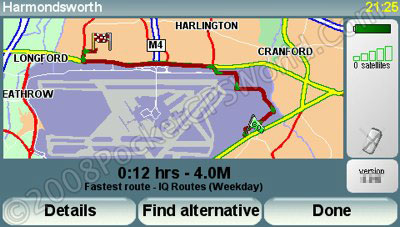
This route looks reasonable to me?
_________________
Darren Griffin |
|
| Back to top |
|
|
emjaiuk
Frequent Visitor
![]()
Joined: Dec 06, 2003
Posts: 335
Location: North Surrey (TW17) UK
|
| Posted: Thu May 22, 2008 9:55 pm Post subject: |
|
|
The latest version of TT maps hyave changed the status of a lot of roads at LHR, from public to private. Why TT/Teleatlas have chosen to make the change is anyones guess. I use LHR a lot, and it is only a minor irritation, but there must be hundreds of drivers , both commercial and private who find it a real pain. The problem also occurs if you are visiting somebody who lives on a private estate, or unadopted roads. I've also found it at places like National Trust places
_________________
Go740L App 9.510 Europe 985.8155
RDS_TMC mount
Home 2.8.3.2499 Win10 Home |
|
| Back to top |
|
|
Andy_P
Pocket GPS Moderator

Joined: Jun 04, 2005
Posts: 19991
Location: West and Southwest London
|
| Posted: Thu May 22, 2008 10:39 pm Post subject: |
|
|
Well this IS something that you can change immediately on your own map with Mapshare.
The only way the TomTom can mark "Private" roads is to block them in both directions. Using Map Corrections in the menu, simply select each access road and unblock it.
It's up to you whether you agree to share this info with others, but I suggest you DO. If enough peole do this maybe it will make TomTom/Tele Atlas re-think this daft policy.
(They have done the same thing with lots of Motorway Service Stations, and if you can't drive onto those, what on Earth are they there for!!!  ) ) |
|
| Back to top |
|
|
philpugh
Lifetime Member

Joined: Dec 28, 2005
Posts: 2003
Location: Antrobus, Cheshire
|
| Posted: Fri May 23, 2008 1:52 pm Post subject: |
|
|
| Andy_P2002 wrote: |
(They have done the same thing with lots of Motorway Service Stations, and if you can't drive onto those, what on Earth are they there for!!! ) |
Are they making a distinction between publicly owned roads and privately owned roads? If indeed the LHR internal roads are privately owned by BAA this may be the case. It also has implications on car insurance - I believe there is a clause in most that allows them (the ins. company) to get out of paying you if you are on a private road whne you have an accident. There used to be a road near where I live that was owned by ICI. I know of one person that had a major issue with his insurance company with what what a very minor bump. The road has now been closed to all traffic by barriers.
It would then seem sensible to avoid routing people through them. Can you set a destination within the area and get a routing to it?
I haven't used TT since Nav6 and maps 660 so can't comment on the latest mapping.
_________________
Phil |
|
| Back to top |
|
|
Andy_P
Pocket GPS Moderator
Joined: Jun 04, 2005
Posts: 19991
Location: West and Southwest London
|
| Posted: Fri May 23, 2008 2:55 pm Post subject: |
|
|
| philpugh wrote: |
It would then seem sensible to avoid routing people through them. |
I can understand that for a single private road, but surely not for things like airports and service stations.
| philpugh wrote: | | Can you set a destination within the area and get a routing to it? |
It varies, often not.
Which can make navigating to a petrol station off the Motorway a classic daft example. |
|
| Back to top |
|
|
|
![]() Posted: Today Post subject: Pocket GPS Advertising Posted: Today Post subject: Pocket GPS Advertising |
|
|
We see you’re using an ad-blocker. We’re fine with that and won’t stop you visiting the site.
Have you considered making a donation towards website running costs?. Or you could disable your ad-blocker for this site. We think you’ll find our adverts are not overbearing!
|
|
| Back to top |
|
|
|


