|
|
 |
 |
 |
 |
| PocketGPSWorld.com Event Article |
|
 |
 |
 |
 |
|
|
|
|
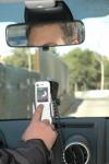
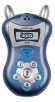
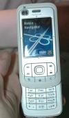
Nokia 6110 Navigator in action
Yesterday I had the chance to talk one to one with the Navigation team from Nokia. In an hour long session I was taken out in the Nokia car around the streets of Barcelona for a demonstration of the new 6110 Navigator. I had seen the device at a distance in the press conference on Monday, but I was now to be one of the first people to get my hands on a device to see it in action.
Unlike the N95 which also has built in GPS functionality this phone is targeted at the mass market, but not only that Nokia insiders suggest that most of the series 60 phones that will be released this year will also have built in GPS technology. Although they stopped short when I asked the number of new phones and if all of them would be GPS enabled the future looks good for connected GPS devices.
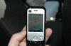
The demonstration of the 6110 Navigator was as would be expected very successful. Although Barcelona does not have the urban canyons that are experienced in New York there are still plenty of high rise buildings and narrow streets, the Navigator performed faultlessly drawing in a strong signal even in the depths of the rear seat of the car. The Nokia 6610 Navigator has a dedicated button to launch the navigator showing the thought put in to the design of the device. One of the issues with navigation applications is the performance of the device's power supply with GPS running as well as the GSM and screen. The team estimate a battery life of 3-4 hours for in-car applications the phone can be powered from the cigar lighter adapter.
The 6610 works straight out of the box. the navigation application is pre-installed with the maps of your country/region, and additional maps are provided on a DVD. These additional maps do require payment and activation, but at least you do get them and dont have to find a retailer to get additional data.
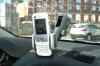
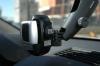
Options available include a car mount and power adapter enabling it to be used in the car. Interestingly although the name emblazoned on the mount is Nokia, the mount is actually made by Herbert Richter in Germany. This means that if the windscreen mount is not your preferred method of locating the device in the car you can choose from a range of mounting solutions from HR.
One surprise was the selection of Route66 as the navigation application on the device, particularly as Nokia have their own navigation application. I was informed that the 6110 Navigator had been in development and production before the purchase of Gate5.
One of the first questions that we always ask when looking at a GPS device is: "What chipset are you using?". When I put this question to Nokia I met with a stone wall... We are not telling you they said. I pointed out that I may be tempted to take my review sample to pieces and find out myself, but that still didnt get a reply. Anyway asking about a bit it turns out that they are using the Texas Instruments chipset. I feel a trip to the TI stand coming on today...
The Nokia 6110 Navigator is probably the highlight of the 3GSM week for me. Not specifically for what is is, but more for the message that it sends out for the future. Nokia have taken a view of the potential market, and invested in a navigation company last year. This year they introduce the n95 a high end smartphone (sorry we have to call these multimedia computers now) with integrated GPS. Now with the launch of a mass market device with navigation the real start of GPS as a core technology and navigation as a must-have lifestyle enhancement is here. The explosion of SatNav PNDs (installed base in the low millions) will pale into insignificance over the next year or two when GPS smartphones go SuperNova (Nokia talk about 100 million units a year!!!)
Article by Mike Barrett on Wednesday, February 14 @ 09:33:31 UTC
|
|
|
|
|
|
|
|
|
|
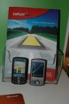
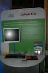
ALK launch CoPilot for the Blackberry
Today ALK increased the number of devices it runs on by launching CoPilot 7 on the Blackberry Smartphones. This application includes:
Full featured voice-guided GPS navigation with clear colourful mapping for BlackBerry® devices
Detailed NAVTEQ maps with over 1 million Points of Interest and full UK postcodes
Easy destination entry via house number, street or BlackBerry® address book contact
Plus of course all the other features of the CoPilot 7 system announced on Monday.
The following is the ALK Press release:
ALK Technologies announces CoPilot Live GPS navigation for BlackBerry
Full-featured GPS navigation with integrated fleet management and tracking for the latest BlackBerry® smartphones, including the BlackBerry® Pearl and the new GPS-ready BlackBerry® 8800.
Full featured voice-guided GPS navigation with clear colourful mapping for BlackBerry® devices.
Server-based navigation. Latest maps and Points of Interest are downloaded rapidly over the mobile data network each trip.
Integrated Safety Camera alerts and traffic warnings.
Detailed NAVTEQ maps with over 1 million Points of Interest and full UK postcodes.
Individual real-time Internet location tracking as standard. Optional FleetCenter multivehicle tracking and management.
Easy destination entry via house number, street or BlackBerry® address book contact
February 13th 2007, 3GSM World Congress, Barcelona. ALK Technologies today announced CoPilot® Live GPS navigation software for the latest BlackBerry® devices, supporting both the BlackBerry® Pearl and the new GPS-ready BlackBerry® 8800. CoPilot® Live BlackBerry Edition is the first server-based "off-board" CoPilot navigation system from ALK, and reflects the company's ambition of making premium, full-featured GPS navigation available for the widest possible range of phones and devices.
CoPilot Live transforms a BlackBerry® into a powerful satellite navigation system, complete with clear voice guidance, detailed street mapping and powerful route calculation. Maps are downloaded automatically to the phone during a journey via the mobile internet and complete door to door trips are calculated in seconds
on the device.
Entering destinations is made simple with a choice of full UK postcode, house number, street or a BlackBerry address book contact. Home and work locations can be saved for easy one-touch navigation to the most commonly visited places.
As with all CoPilot navigation systems, CoPilot Live BlackBerry Edition's driver safety mode is designed to avoid distraction when out on the road by only displaying a map on the approach to a turn, at which point a colourful auto-zoom map shows the way ahead. If a turn is missed during the journey CoPilot works out the best new route in seconds, while an instant detour button can find an immediate route around unexpected congestion.
Out on the road does not mean out of touch. CoPilot Live BlackBerry Edition incorporates location-specific Live services that provide useful information to drivers and enabling safe interaction with others. Traffic information is delivered directly into CoPilot Live via the mobile internet, offering the choice to avoid or ignore reported incidents. Real-time location tracking is included as standard, allowing colleagues, friends
or family to view your location in real-time, send messages and even new destinations directly to CoPilot Live via a secure web site.
For a small monthly subscription, BlackBerry® devices with CoPilot Live navigation can be connected seamlessly to ALK's LBS Challenge award-winning fleet management service FleetCenter for multivehicle tracking, messaging, job despatch and reporting a simple web interface. Businesses of all sizes can gain real-time visibility and management of mobile assets easily and cost-effectively using mobile
phones.
A safety camera warning system is included as standard, with camera locations updated monthly. On-screen and spoken alerts provide warnings on the approach to each camera, encouraging safer driving and reducing the risk of license loss.
Michael Kornhauser, Vice President, Managing Director of ALK Technologies said "now BlackBerry users can experience high quality, feature-packed satellite navigation without needing to invest in additional hardware or a dedicated navigation system. The launch of this off-board version of CoPilot Live is another important milestone in our quest to provide customers with a great navigation experience on the widest range of mobile phones."
CoPilot Live 7 will be initially available for the BlackBerry® Pearl and the new BlackBerry® 8800 with in-built GPS receiver.
Article by Mike Barrett on Tuesday, February 13 @ 19:52:17 UTC
|
|
|
|
|
|
|
|
|
|
Garmin launch two new Bluetooth Enabled Mobile navigation solutions
We saw the Garmin Mobile 10 and 20 solutions in Las Vegas at CES. These add navigation to your mobile device in one of two ways. The Mobile 10 uses a Bluetooth GPS receiver, whilst the Mobile 20 implements a Bluetooth Cradle and is suited for a car.
I will be visiting the Garmin stand shortly for more details in the mean time here is the Garmin Press Release:
Get sat nav on your smartphone with Garmin
Garmin has today launched a solution to turn Bluetooth wireless technology enabled smartphones, PDAs, BlackBerry® devices and laptops into navigators. The new products will be on show in Europe for the first time at the mobile communications show 3GSM, in Barcelona. The Garmin stand number is number is 7F42 in Hall 7.
Garmin Mobile 10 gives you voice-prompted, turn-by-turn directions while showing a moving map on your handsets display. You also have the ability to access real-time information such as traffic alerts and weather reports. It can be used either in a car or while out and about on foot.
Garmin Mobile 20 has similar features to the Garmin Mobile 10 and is designed to be a simple way to turn your phone into an in-car satellite navigation system. It works by placing your handset into a cradle which can then be mounted onto your dashboard.
Both solutions work with a wide range of handsets. See http:// HYPERLINK "http://www.garmin.com/mobilephones" www.garmin.com/mobilephones
Garmin Mobile 10
Garmin Mobile 10 works by receiving positional data via GPS (Global Positioning System) and communicates this information to mobile devices via Bluetooth wireless technology. To enable this to happen the Garmin Mobile 10 package includes a GPS10x which is a small yet highly sensitive GPS receiver. This comes with a removable clip to make it easy to wear on your belt or use in a car and can be used with smartphones, PDAs, BlackBerry devices and laptops.
Also included is a DVD with Garmin Mobile XT software which provides the menu system to navigate and find points of interest. The City Navigator® NT mapping of North America, Europe or a selected region provides you with the ability to navigate to your selected destination using voice guidance and a 3D map on the phones display. These simply have to be downloaded onto a memory card and inserted into your handset.
Alternatively you can choose a package that includes a handset-specific memory card that has pre-programmed mapping and navigation software. This enables the user to simply slot the card in place and navigate straight away.
For those who want to use their Bluetooth enabled laptop as a satellite navigation device, the nRoute navigation software (which comes with the Garmin Mobile 10 package) makes this possible.
Garmin Mobile 20
Garmin Mobile 20 is specifically designed for use in a car or other vehicle. It works by inserting your handset into a specially designed cradle called the GPS 20SM. In addition to having a built-in high sensitivity GPS receiver, the GPS 20SM smart mount also serves as a Bluetooth hands-free calling kit, phone charger and phone cradle. It is easily mounted to a dashboard or windscreen.
As part of the package different charging cables are provided for a variety of handsets, an automotive mount to attach the Garmin mount to your dashboard and a memory card containing Garmin Mobile XT software and City Navigator NT maps. These are preloaded so all you have to do is slot the card into your handset to get the familiar Garmin menu systems by which to navigate your way around as well as mapping for North America, Europe or your selected region.
The result
Garmin Mobile 10 and Garmin Mobile 20 give owners the same high-quality map and navigation features found on other Garmin automotive GPS devices. You can search for a destination using a full postcode search and choose the shortest or fastest route for your journey. There are voice-prompted, turn-by-turn directions with a 3D moving map displayed on your phone. The device also automatically recalculates a route if the driver misses a turn, and it will also notify drivers of their estimated time of arrival.
Both options allow the user to look up millions of points of interest such as restaurants, hotels and petrol stations. There is the capability for you to access real-time traffic information, weather reports, safety camera alerts and more. It is also possible to select a Pedestrian or Car mode in order to get the most appropriate route for your method of travel.
The choice is yours. The Garmin Mobile 10 is ideal if you want to navigate on the go, whether in the car or on foot. If you want a plug and play solution for your car without the extra expense of an additional system, the Garmin Mobile 20 provides the perfect solution.
Article by Mike Barrett on Monday, February 12 @ 17:15:51 UTC
|
|
|
|
|
|
|
|
|
|
Judging is complete in the Navteq 2007 LBS Challenge Competition
Today, Sunday 11th February, saw the cumulation of the judging of the Navteq 2007 European LBS Challenge. Along with a number of other judges from the Mobile and Navigation sectors the finalists of the competition presented their LBS applications. The competition was organised in three categories representing Social Networking, Business Applications, and Navigation.
In the Social Networking there were 3 very different applications covering photo blogging, geo gaming, and tourism.
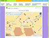
AtlasCT showed an application which captures a GPS track (from either an integrated GPS or external BT GPS receiver) and also allowed you to take pictures, or notes which were geo-referenced. This data is then transferred to a server where the route is displayed along with the placeholders for the images and notes. Additional images can be added using a conventional camera these will then be inserted into the photo blog based on the timestamp of the image and the time on the GPS track. The back end allows users to send the blogs to friends and family and also export in a different format such as Google Earth. Images can be taken anywhere in the world and displayed in this system. The detail of the map shown will depend on the country the image was taken in. If it is in one of the countries covered by Navteq Mapping then you will get street level detail.
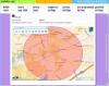
TikGames won the Social Networking category last year, and were back again with another more advanced Geo Game: Interpol: Stolen Artifacts. Basically this is an organised geocache adventure. There are a number of connected stages in the treasure trail, each gives a clue to the location of the next clue, culminating in the winning of the prize... The game is a good example of the integration of mapping, GPS and geo tasks. You can see where you are on a Navteq map downloaded from a central server, navigate to the destination (not turn by turn) and then when you have solved the puzzle you enter the solution. Now here is a clever bit... To stop people cheating the game will only accept the answer to the stage if your GPS location is within a certain tolerance. This has all sorts of interesting applications in the real world, particularly from sponsors, and maybe rewarded city guides and hi-tech educational games.
8Motions presented a mobile tourist application that allows users to contribute to a community city guide project. Rather than provide a formal point to point itinerary 8Motions allows users to create their own content and together with geo-coded images build and share the data with friends and the rest of the community. Also included are buddy functions allowing you to share your location data with your friends in the local vicinity.
In the Business applications section we had entries from Senda, Smarter Agent, and UbiEast. These companies provided some examples of interaction between local communities integrating technology and localisation.
Senda showcased a realtime delivery information service. As a proof of concept the system aggregates data from a number of sources and provides them to the user overlaying Navteq maps. The software looks at next generation data collection and dissemination to the community. Particular examples given were the use of "fluid car monitoring" to provide feedback and enhance the traffic data supplied by official sources. For instance it can determine if you drive through an area at normal speeds when the traffic system is showing delays and reset the traffic system info to actual road conditions. It also provides anonymous feedback about the general flow of traffic. Another application shown was to take information for the car park operators and display availability, allowing you to make an informed decision about where to park when arriving at your destination.
SmarterAgent combines location data with a database of property allowing users to efficiently search for a new home. Essentially in certain areas in Europe and across the USA you can drive to a neighborhood that you would like to live in and start the application. Once loaded it will do a search of its database and display all the properties for sale or rent in the area. The results are displayed in a manner that the properties can be selected and visited externally without the need to involve the agent in charge of the property. This has a number of potential uses as not only does it access current properties available on the market, but historical data too allowing you to make an informed decision about your potential new home.
UbiEast demonstrated an off-board (server based) navigation system. The server based solution allows you to have a thin client on the navigation device with all the processing and decision making taking place on the server. This means that new mapping data can be added at any time ensuring that you always have the latest maps. New and improved system modules can be added at any time without the user needing to install new software etc. UbiNav is a flexible product which has inbuilt friend/buddy features, and amusing computer simulation help system, and the ability to have fleet management in the backend (internet) system.
In the navigation final we had entries from Jentro, Navman, and Sharpmind. All three presented very different and innovative approaches to adding new functionality or features to mobile phones.
Jentro displayed activepilot, an off-board navigation system, capable of being deployed on any java enabled platform. Not only does it have a very light client, but it is also advanced enough to offer text to speech navigation instructions as well. The navigation displays Navteq maps in either 2D or 3D views with a relatively small footprint allowing for quick and small sized maps to be downloaded. Jentro also have a feedback module which passes traffic information back to the server generating dynamic traffic flow data from the community.
Navman are well known to the PocketGPSWorld.com community, but here they were demonstrating some of the lesser known features of the mobile product Mobile Travel Assist as well as the popular NavPix. This uses aggregated data sources to provide not only city guides, but also pertinent travel related information such as finding and displaying flight information for the nearest airports between two locations, this includes identifying not only possible primary airports for the journey, but also possible alternate ones as well.
The last finalist is SharpMind who showed us QuickFinder: "making the most of here and now". The emphasis with QuickFinder is on the now. The application is connected through to a database which has time related information. This means that for a user doing a search for pharmacies can select to show only those that are open. The application has the intelligence to determine which is the closest and what the opening times are. Based on this it can display the nearest open pharmacy. A second example showed the nearest metro station, you could then drill down into the data and show the timetable for that particular station. This application is not based on GPS location, but on Cell Id. Although not as accurate as GPS it is good enough to provide a location and it removes the reliance on additional GPS hardware.
So who has won? Your guess is as good as mine. There was a lot of good applications competing this year, and it was difficult for me to separate some of the entries. I know which one I think could be the winner, we will have to wait to see if the other judges concur. As happened last year the winner will be announced at the LBS Challenge Award ceremony on Tuesday... Of course I will report back as soon as I know the outcome.
Article by Mike Barrett on Sunday, February 11 @ 22:17:09 UTC
|
|
|
|
|
|
|
|