| View previous topic :: View next topic |
| Author |
Message |
MikeB
Frequent Visitor

Joined: 20/08/2002 11:51:57
Posts: 3859
Location: Essex, UK
|
 Posted: Thu May 31, 2007 8:30 pm Post subject: ViewRanger's new software supports Nokia's N95 GPS phone Posted: Thu May 31, 2007 8:30 pm Post subject: ViewRanger's new software supports Nokia's N95 GPS phone |
 |
|
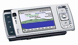 ViewRanger is an innovative piece of software displaying the UK Ordnance Survey mapping products on mobile phones. Developed Nokia S60 phones and being accredited with the Symbian Signed status the software takes full advantage of the new GPS enabled phones released by Nokia. ViewRanger is an innovative piece of software displaying the UK Ordnance Survey mapping products on mobile phones. Developed Nokia S60 phones and being accredited with the Symbian Signed status the software takes full advantage of the new GPS enabled phones released by Nokia.
Apart from the "normal" OS map display ViewRanger also has a unique panoramic view, and also has a "Buddy Locator" to transmit your position to friends and family either via other ViewRanger enabled devices, or over the Internet.
The full ViewRanger press release:
| ViewRanger Press Release wrote: |
Cambridge, UK 30th May 2007 Augmentra, a leading innovator in gps-enabled navigation software for smartphones, today announced the latest version of its award-winning ViewRanger off-road mapping, navigation and information software, and announced support for the Nokia N95 with integrated GPS.
ViewRanger is specifically designed for the off-road user, whether hill-walker, mountain biker, geo-cacher, birdwatcher, or rural tourist. It offers a unique combination of 2D and 3D mapping, GPS navigation, sports performance analysis, content sharing, and buddy tracking.
Running ViewRanger on the Nokia N95 with integrated GPS removes the need for a separate GPS receiver.
The N95s high-resolution, bright and crisp screen is perfect for displaying the fine detail of 1:50,000 and 1:25,000 topographic maps. The 5 megapixel camera allows the sharpest images to be captured, marked on the map, and shared over-the-air via the ViewRanger Information Exchange. All of England (or Scotland) at 1:50,000 scale can be held on the Nokia N95 via a single microSD memory card.
Whether a frequent outdoor sports participant, or just an occasional visitor to the countryside, ViewRanger and the Nokia N95 deliver capabilities and convenience that cannot be found elsewhere.
This latest version of ViewRanger includes many features that allow outdoor enthusiasts to locate, identify, navigate and connect:
High quality multi-scale mapping licensed from Ordnance Survey
Unique 3D Panoramic Viewpoint display that identifies features in the landscape
GPS trail navigation and tracklog recording, with support to import/export waypoints, tracks and routes to many PC applications including Google Earth
TripView sports computer to monitor data during a journey and analyse performance
Buddy Beacon to transmit location to friends and family; see the location on your ViewRanger handset or through the web
Exchange notes and photos to share experiences of the landscape via ViewRangers over-the-air Information Exchange
Having achieved Symbian Signed status, we are delighted that ViewRanger is one of the first third-party mapping and navigation applications to support the Nokia N95 and its integrated GPS, said Mike Brocklehurst, CTO, Augmentra Ltd. ViewRanger and the N95 set a new benchmark for functionality, ease-of-use and convenience in outdoor GPS.
ViewRanger runs on the Symbian S60 smartphone platform, and transforms a Nokia or other S60 handset into a full-featured trail navigation system. ViewRanger is available to use internationally with no base-maps, and with Ordnance Survey mapping of Great Britain. Further international coverage will be announced shortly.
ViewRanger is available from www.viewranger.com and selected retailers.
For a complete list of supported handsets and ViewRanger resellers please visit ViewRanger at www.viewranger.com
|
_________________
Mike Barrett |
|
| Back to top |
|
 |
diggerhole
Occasional Visitor

Joined: Apr 04, 2006
Posts: 6
|
| Posted: Sun Jun 03, 2007 8:34 pm Post subject: Viewranger |
|
|
have used veiwranger since my 6680 a excellent piece tool, use it extensivly when hiking, at £20 odd for a custom map selection of a good chunk of the uk well worth the money
Home it keeps developing |
|
| Back to top |
|
|
SvenP
Lifetime Member
Joined: Jan 28, 2006
Posts: 33
Location: Nottinghamshire, UK
|
| Posted: Tue Oct 30, 2007 7:43 pm Post subject: |
|
|
| I have to say that I think ViewRanger is superb. I have just had a chance to test it out for real; I forgot to pack my map and compass during a recent walk in the Lakes. I found out my mistake after having climbed St Sunday crag. Fortunately I had ViewRanger v2.4.3 (beta) installed on my N95 so I was OK. |
|
| Back to top |
|
|
AndrewPage
Occasional Visitor
Joined: Apr 04, 2006
Posts: 3
|
| Posted: Thu Jan 10, 2008 6:05 pm Post subject: N95 and OS maps |
|
|
I have a fairly new N95. Does this software use the N95's built in GPS receiver?
I am looking for software to use with OS maps and the N95 as a back up to maps for walking etc. |
|
| Back to top |
|
|
Darren
Frequent Visitor

Joined: 11/07/2002 14:36:40
Posts: 23848
Location: Hampshire, UK
|
| Posted: Thu Jan 10, 2008 6:14 pm Post subject: Re: N95 and OS maps |
|
|
| AndrewPage wrote: | | Does this software use the N95's built in GPS receiver? |
Taken from the full ViewRanger press release in the first post:
| ViewRanger Press Release wrote: |
Running ViewRanger on the Nokia N95 with integrated GPS removes the need for a separate GPS receiver.
|
_________________
Darren Griffin |
|
| Back to top |
|
|
AndrewPage
Occasional Visitor
Joined: Apr 04, 2006
Posts: 3
|
| Posted: Thu Jan 10, 2008 6:48 pm Post subject: OS Maps |
|
|
OK I've read the info now and it does use the built in GPS. Fantastic.
As I already have some electronic OS maps can I use them on it or are they a specific file type? |
|
| Back to top |
|
|
SvenP
Lifetime Member
Joined: Jan 28, 2006
Posts: 33
Location: Nottinghamshire, UK
|
| Posted: Thu Jan 10, 2008 7:29 pm Post subject: |
|
|
The Viewranger maps seem to be in a custom format. For each Viewranger map you have there are three files that have to be on your phone. *.VRC, *.VRH and *.VRM. I had hoped that these would be similar to the Memory Map files, namely *.QCT, *.QED and *.MMI. Unfortunately, just renaming the Memory Map files and trying to use them with Viewranger doesn't work for me.
If you work out a way of doing this it would save me a lot of money, as I am currently looking to buy the Viewranger 25k map of the Lake District although I already own the Memory Map one. |
|
| Back to top |
|
|
Darren
Frequent Visitor
Joined: 11/07/2002 14:36:40
Posts: 23848
Location: Hampshire, UK
|
| Posted: Thu Jan 10, 2008 8:06 pm Post subject: |
|
|
The maps are in a proprietary format and cannot be converted.
_________________
Darren Griffin |
|
| Back to top |
|
|
SvenP
Lifetime Member
Joined: Jan 28, 2006
Posts: 33
Location: Nottinghamshire, UK
|
| Posted: Thu Jan 10, 2008 9:10 pm Post subject: |
|
|
| Similar topic to the discussion last November with you, Darren on uk.rec.gps. Is it fair that as end users we have to pay twice for the same data? |
|
| Back to top |
|
|
Darren
Frequent Visitor
Joined: 11/07/2002 14:36:40
Posts: 23848
Location: Hampshire, UK
|
| Posted: Thu Jan 10, 2008 9:16 pm Post subject: |
|
|
It's a huge issue and I understand the grievances but that's how it currently is and isn't just confined to OS mapping. You could argue the same about mapping for TomTom not being compatible or transferable to another manufacturers device.
_________________
Darren Griffin |
|
| Back to top |
|
|
SvenP
Lifetime Member
Joined: Jan 28, 2006
Posts: 33
Location: Nottinghamshire, UK
|
| Posted: Thu Jan 10, 2008 9:39 pm Post subject: |
|
|
Unfortunately, I doubt that by grousing about these issues we will achieve any change in policy, unfortunately.
I can understand how people feeling ripped off by OSGB could be tempted to go down the various Usenet and P2P routes to get the mapping data without paying for it. This sort of illegal stuff is all over the net and far too easy to come by. But who is cheating who, I wonder? |
|
| Back to top |
|
|
AndrewPage
Occasional Visitor
Joined: Apr 04, 2006
Posts: 3
|
| Posted: Thu Jan 10, 2008 9:54 pm Post subject: Maps |
|
|
Thanks for all the info.
Have downloaded the trial version and the UK map and Snowdon.
N95 found me on the UK trial map by holding the phone to the window.
It looks like you can get quite a lot of map for your money at 1:50,000 so probably worth it compared to the price of paper maps.
Thanks again |
|
| Back to top |
|
|
|
![]() Posted: Today Post subject: Pocket GPS Advertising Posted: Today Post subject: Pocket GPS Advertising |
|
|
We see you’re using an ad-blocker. We’re fine with that and won’t stop you visiting the site.
Have you considered making a donation towards website running costs?. Or you could disable your ad-blocker for this site. We think you’ll find our adverts are not overbearing!
|
|
| Back to top |
|
|
|


