| View previous topic :: View next topic |
| Author |
Message |
RobBrady
Frequent Visitor

Joined: Jul 21, 2004
Posts: 2718
Location: Chelmsford, UK
|
 Posted: Thu Jan 24, 2008 2:46 pm Post subject: A to Z Maps announce partnership with PocketGPSWorld.com Posted: Thu Jan 24, 2008 2:46 pm Post subject: A to Z Maps announce partnership with PocketGPSWorld.com |
 |
|
 Despite the recent massive growth in satnav use, there is still a very healthy market for paper based road atlases. Despite the recent massive growth in satnav use, there is still a very healthy market for paper based road atlases.
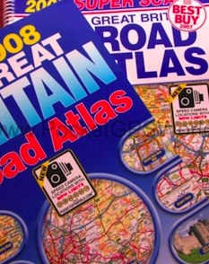
A to Z have joined the fast growing ranks of well-known online and offline brands who have partnered with PocketGPSWorld.com to make use of our highly accurate safety camera information. They will be introducing our speed camera locations to a number of their printed publications over the coming year.
Already crowned an Auto Express Best Buy, the first of many partnership publications to launch this year is the 2008 Super Scale Road Atlas which is available at www.a-zmaps.co.uk. This spiral bound road atlas of Great Britain features safety camera locations on the road mapping and main route mapping with the maximum speed limit at each of these locations also displayed.
More than 4000 fixed camera locations are shown, including Gatso, Truvelo, SPECS and Monitron camera types. Selected truckstop locations in England and Scotland are also included on the road mapping.
A to Z advocate the responsible use of safety camera information. They say, "It is the drivers absolute responsibility to be aware of, and to adhere to, speed limits at all times. Safety Cameras are sited at locations with a known history of serious or fatal accidents and where speeding is also a regular or contributory problem. By showing this safety camera information it is the intention of Geographers' A-Z Map Company Ltd., to encourage safe driving and greater awareness of speed limits and vehicle speed."
Later this year, A to Z's new London publications will be printed which will also include our safety camera information.
From A to Z:
"2008 Super Scale Road Atlas: This 232 page atlas is known for its superb scale and clarity, achieved by careful use of colour, type-face and road widths down to the finest detail at motorway junctions. Road map information includes motorways open with full junction detail, motorways under construction and proposed, motorway service areas, primary routes and destinations, A & B roads, gradients 1:5 and steeper, tolls, mileages, national and county boundaries, together with spot heights and contour colouring.
A wide range of tourist and ancillary information is featured on the mapping. Also included in the atlas is a route planning section, main route maps covering London, Birmingham and Manchester, a mileage chart, a Channel Tunnel Map, details of motorway junctions with limited interchange and a section with information about the Safety Cameras. There are 70 city and town centre plans and 16 Port and Airport plans. The comprehensive index lists over 31,000 town, village, hamlet and locality names including selected places of interest."
_________________
Robert Brady |
|
| Back to top |
|
 |
GPS_fan
Pocket GPS Moderator


Joined: Jan 04, 2007
Posts: 2789
Location: Hampshire, UK
|
| Posted: Thu Jan 24, 2008 3:52 pm Post subject: |
|
|
Congratulations to the team
Perhaps this is a foot in the door to getting the PGPSW 'brand' more widely recognised by the general public.
_________________
Andy
PocketGPSWorld.com supports Help for Heroes - Read here |
|
| Back to top |
|
|
Darren
Frequent Visitor

Joined: 11/07/2002 14:36:40
Posts: 23848
Location: Hampshire, UK
|
| Posted: Thu Jan 24, 2008 4:01 pm Post subject: |
|
|
We do have deals with a number of printed mapping providers, this however is the first where we have secured 'star billing'.
Next time you see a road map with cameras in WH Smiths, take a peek inside the front cover and look at the credits.
We will be working hard to get the brand much more widely known in coming months so keep your eyes peeled in the motoring press etc 
_________________
Darren Griffin |
|
| Back to top |
|
|
Skippy
Pocket GPS Verifier


Joined: 24/06/2003 00:22:12
Posts: 2946
Location: Escaped to the Antipodies! 36.83°S 174.75°E
|
| Posted: Thu Jan 24, 2008 8:56 pm Post subject: |
|
|
Good work lads, that is an excellent result! 
_________________
Gone fishing! |
|
| Back to top |
|
|
MaFt
Pocket GPS Staff


Joined: Aug 31, 2005
Posts: 15388
Location: Bradford, West Yorkshire
|
| Posted: Thu Jan 24, 2008 9:03 pm Post subject: |
|
|
how about an atoz map as a runners up prize in the next competition? - "didn't win a sat nav? ah well, here's a paper map instead" 
MaFt |
|
| Back to top |
|
|
GPS_fan
Pocket GPS Moderator
Joined: Jan 04, 2007
Posts: 2789
Location: Hampshire, UK
|
| Posted: Thu Jan 24, 2008 10:42 pm Post subject: |
|
|
| MaFt wrote: | how about an atoz map as a runners up prize in the next competition? - "didn't win a sat nav? ah well, here's a paper map instead"
MaFt |
At least there are no batteries to go flat or software to fail...I don't know what happens if you hold it the wrong way up though - map reading is a skill that shouldn't be lost 
How's this clip for geography? Here
_________________
Andy
PocketGPSWorld.com supports Help for Heroes - Read here |
|
| Back to top |
|
|
telematicsman
Occasional Visitor

Joined: Jul 31, 2006
Posts: 19
Location: Andover Hampshire UK
|
| Posted: Mon Feb 04, 2008 11:16 pm Post subject: How about including loads and height restrictions |
|
|
A few years ago the AA published an atlas with width, axle loading and height restrictions aimed at the haulage industry. The FTA was also involved. How about acquiring this information in the same way Pocketgps gets the speed camera info?
It would also be possible to include tracks vs. metalled roads and other problem navigation issues. The Haulage industry could certainly use it as could the bus industry. In my town we have had three re-enactments of the bus chase from 'Live and Let Die' due to drivers of double deckers being unaware of an 11 foot bridge. The schoolkids on the third bus were very lucky indeed.
It could be argued that some of these things are a case of preparation before using the Satnav but often the trouble starts when a driver is forced onto unfamiliar roads by congestion, road closure and the need to keep to schedule.
The resulting information would be a product of value to truckers, Atlas and satnav producers alike. Somebody needs to do this so why not PocketGPS? |
|
| Back to top |
|
|
Darren
Frequent Visitor
Joined: 11/07/2002 14:36:40
Posts: 23848
Location: Hampshire, UK
|
| Posted: Tue Feb 05, 2008 8:30 am Post subject: |
|
|
it's a good idea but one that is too late for us sadly. Both TeleAtlas and Navteq have announced such data will be available this year in mapping.
_________________
Darren Griffin |
|
| Back to top |
|
|
M8TJT
The Other Tired Old Man

Joined: Apr 04, 2006
Posts: 10118
Location: Bexhill, South Sussex, UK
|
| Posted: Tue Feb 05, 2008 8:40 am Post subject: |
|
|
| Darren wrote: | | it's a good idea but one that is too late for us sadly. Both TeleAtlas and Navteq have announced such data will be available this year in mapping. |
And we all know how accurate and up to date their data is, don't we  |
|
| Back to top |
|
|
Darren
Frequent Visitor
Joined: 11/07/2002 14:36:40
Posts: 23848
Location: Hampshire, UK
|
| Posted: Tue Feb 05, 2008 8:44 am Post subject: |
|
|
True, I'll put the suggestion to my colleagues and see what the consensus is 
_________________
Darren Griffin |
|
| Back to top |
|
|
MaFt
Pocket GPS Staff
Joined: Aug 31, 2005
Posts: 15388
Location: Bradford, West Yorkshire
|
| Posted: Tue Feb 05, 2008 10:18 am Post subject: |
|
|
| Darren wrote: | | True, I'll put the suggestion to my colleagues and see what the consensus is |
how many devices are able to 'avoid' poi's? i know garmin can't and i don't think i've seen it on many others...
even if the pois are available then the driver would still need to manually go through the router on the device to see if there were any low bridges etc that ould hinder their route then what? make a note on a sheet of paper where to turn off to avoid it then go back on to the original route? and what if that detour tkes you past another low bridge etc?
unless you're lucky enough to have multiple waypoints then that's the only option. in which case it's probably easier to just plan the route by hand anyway, isn't it?
unless the data is within the maps in a format the device can use such as the list of avoid options (avoid toll roads, avoid traffic, avoid ferries etc) then there' till a ot of manual work involved. the only difference would be more up to date data but not less work...
that's my opinion anyway!
MaFt |
|
| Back to top |
|
|
Oldboy
Pocket GPS Moderator

Joined: Dec 08, 2004
Posts: 10644
Location: Suffolk, UK
|
| Posted: Tue Feb 05, 2008 12:07 pm Post subject: |
|
|
| MaFt wrote: | | how many devices are able to 'avoid' poi's? i know garmin can't and i don't think i've seen it on many others... |
TomToms can't.
_________________
Richard
TT 910 V7.903: Europe Map v1045
TT Via 135 App 12.075: Europe Map v1145 |
|
| Back to top |
|
|
telematicsman
Occasional Visitor
Joined: Jul 31, 2006
Posts: 19
Location: Andover Hampshire UK
|
| Posted: Tue Feb 05, 2008 12:07 pm Post subject: |
|
|
| MaFt wrote: | | Darren wrote: | | True, I'll put the suggestion to my colleagues and see what the consensus is |
how many devices are able to 'avoid' poi's? i know garmin can't and i don't think i've seen it on many others...
even if the pois are available then the driver would still need to manually go through the router on the device to see if there were any low bridges etc that ould hinder their route then what? make a note on a sheet of paper where to turn off to avoid it then go back on to the original route? and what if that detour tkes you past another low bridge etc?
unless you're lucky enough to have multiple waypoints then that's the only option. in which case it's probably easier to just plan the route by hand anyway, isn't it?
unless the data is within the maps in a format the device can use such as the list of avoid options (avoid toll roads, avoid traffic, avoid ferries etc) then there' till a ot of manual work involved. the only difference would be more up to date data but not less work...
that's my opinion anyway!
MaFt |
True at present but it is a chicken and egg situation. Until the data is available they won't modify their software. However if a suitable database is available then it becomes worth doing this. I am still able to get software updates for my TomTom 700 though it is a few years old. Luckily it won't do the pointless stuff like MP3 playing or running movies...
The cataloguing of all this sort of data for the UK alone is a huge task and the PGPS model of volunteers and and extra logging function in their satnavs is probably the only economic way to compile this information.
The end result would be valuable to Mapmakers, satnav producers and routing software companies as well as helping prevent trucks going through narrow lanes, small villages etc.
Once the database is available ways will be found to use it- Including new model satnavs, software updates and incorporating it into printed maps.
Having seen the results of a bus hitting a low bridge there is certainly a need for better information. |
|
| Back to top |
|
|
|
![]() Posted: Today Post subject: Pocket GPS Advertising Posted: Today Post subject: Pocket GPS Advertising |
|
|
We see you’re using an ad-blocker. We’re fine with that and won’t stop you visiting the site.
Have you considered making a donation towards website running costs?. Or you could disable your ad-blocker for this site. We think you’ll find our adverts are not overbearing!
|
|
| Back to top |
|
|
|


