|
|
 |
 |
 |
 |
| Memory-Map National Parks 1:50,000 mapping review |
24th
April 2006 |
|
Review by Mike Barrett
Sitting on a plane at 40,000 feet what better time than to look at one of the latest mapping products from Memory-Map? Well my wife was sleeping and Rob was away having a massage so I had plenty of time to look at the Memory-Map software and start writing this review...
As most of the review features images from the PC screen I have created small images that are clickable to pop up full sized graphics.
|
|
Overview
Memory-Map have produced a special combination, of selected Ordnance Survey digital maps, the Memory-Map 5 software, and a number of predefined walking routes from Country Walking and Trail magazines. These are all packaged onto a single CD priced at £24.95 and are suitable for outdoor enthusiasts of all skills and capabilities.
These predefined routes consist of 2 icons linked to further information. There is an "I" icon and a "R" icon. The I icons are linked to pdf files which are the magazine route cards. The R icons are linked to memory-map routes. These routes can of course be downloaded to your GPS or PDA and printed as normal.
|


|
Whats in the Box?
In the box is a CD, short instruction leaflet, and a license key. The CD contains not only the 1:50,000 maps, but also has the latest version 5 Memory-Map software on it.
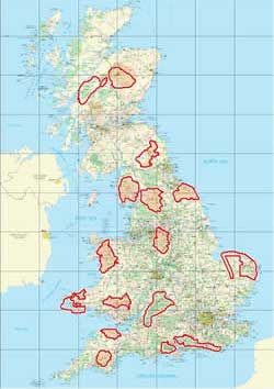
The maps supplied are:
- Glencoe
- Ben Nevis
- Cairngorms
- Norfolk Broads
- Northumberland
- Pembrokeshire Coast National Park
- Lake District
- North York Moors
- Yorkshire Dales
- Snowdonia
- Peak District
- Brecon Beacons
- Exmoor
- Cotswolds
- Dartmoor
- South Downs
- New Forest
- Plus a number of sample maps and charts.
|
 |
Specifications and Compatibility
The following is an extract from the Memory-Map site:
This exclusive product includes OS Landranger 1:50,000 maps of all of Britain's National Parks and other key outdoor leisure areas on a single CD.
Features 150 routes from Trail and Country Walking Magazines
If you need some ideas on where to go, we've teamed up with Trail and Country Walking to include 150 of their best walks as featured in their magazines. Routes are available for different abilities and include easy to follow instructions for a great day out. You can also print your own route map and route card and add your own additional notes or download the route directly from Memory-Map into a GPS.
Memory-Map is already used to create the routes and provide the maps printed in both magazines. You can also add to your Memory-Map route collection with downloads from the magazines websites - www.countrywalking.co.uk and www.trailroutes.com
|
The Memory-Map software requires a PC with DirectX for the 3D capabilities. A range of GPS devices can be programmed using Memory-Map including Garmin, Magellan, Suunto, and Silva. I have used it with my Garmin Geko 301, Etrex, GPSMap 60Cx, Edge 305 and Forerunner 301. I have also used it with a range of MS Windows Mobile pocket PCs.
|
The Memory-Map Ordnance Survey Britain's National Parks mapping review
One of my 'problems' with the Ordnance Survey mapping data for me was that I had to effectively buy the whole country just for the areas that I might visit in a year. Typically these places would be the popular outdoor locations: The Lake District, the New Forest, Snowdonia, and the Brecon Beacons.
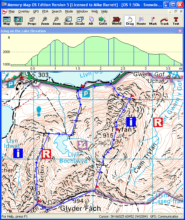
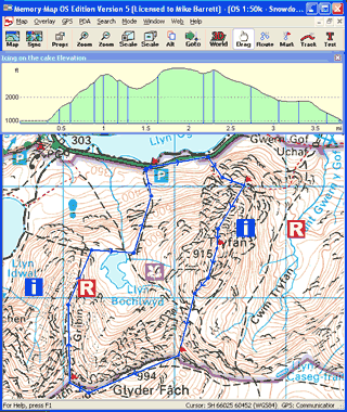
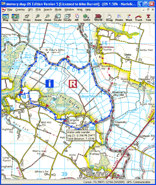
Well Memory-Map have solved most of my problems with the release of the OS Britain's National Parks map disk. But not only does this cover a wide range of popular outdoor maps, but it also includes a large number of walking routes with both electronic routes, such as the one shown to the right, and route cards in PDF format for printing and taking with you on your walk...
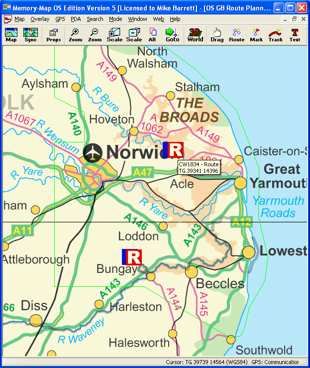
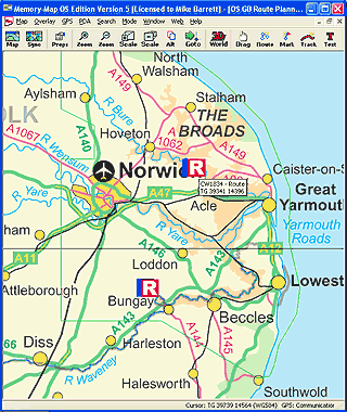
The maps are selected extracts from the 1:50,000 scale series of raster products. Also included is a 1:1,000,000 "route planning" map of Britain. This provides an overview of the areas covered by the more detailed maps. |
|
Shown to the right is an extract from the 1:1,000,000 route planning map. This shows the area around Norwich in Norfolk, which of course includes the Norfolk Broads.
It is a little difficult to pick out on this map, but the outline of the more detailed 1:50,000 map can bee seen. This is indicated by a green line. You can see it running round the coast and then down through the "a" in Aylsham and round Norwich joining the coast at Southwold.
This is actually a bit of a pity as a place I often visit is Minsmere and Dunwich just a few miles to the south, but not part of the Broads... Still I suppose you can't have everything can you?
If you have a PDA you can send either the entire Route Planning map to the device or just the section viewed in the window. This provides a useful overview for locating your position without too much detail on the map. |
 |
The Trails and Walking Routes
When you start Memory-Map you will find you have a file called cw_tr.mmo which you can import from the Overlay/import... menu. This contains a number of icons which are linked to additional data files.
When you have loaded this overlay file you will see two new icons for each of the hundred and fifty routes.
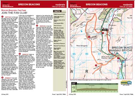
The "i" icon is linked to information about the route as a route card. This is a PDF file which contains descriptions of the features of the route, along with a map and elevation profile. A sample is shown below.
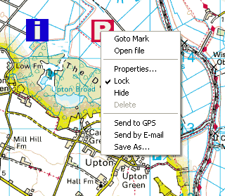
The 'R' icon is linked to a route file. If you right-click on the icon and click "Open file" this will then load the associated route into the Memory-Map application. |
 |
 |
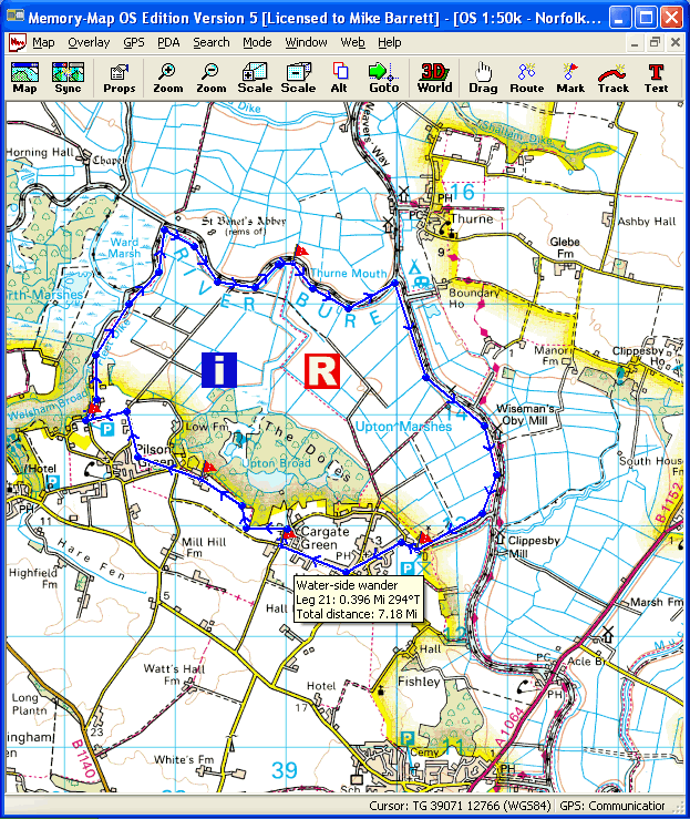
Having opened the route you can now see the route on the screen, this will have loaded the route into the application and will be available now to download to the GPS or PDA or of course further analysis in Memory-Map.
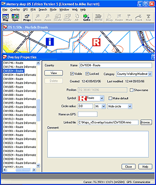
This is a good way to present data in the system as only the "index" information is loaded into the application and this does not clutter up the maps with additional information that you will not use. When you want to look at route simply right click on the route icon and select open file. The route can of course subsequently be hidden at a later point in time simply by unticking it in the properties box.
If you can hide the route why not load it in the first place and have it hidden? Well the simple answer to that is that a route contains not just the route definition, but also a series of waypoints in the route. So for each of the routes we could be looking at the route plus 30 waypoints so about 31 items. Not much on their own, but multiply that by 150 then add in all you existing routes, tracks and waypoints and suddenly you have thousands of data items which slow the Memory-Map system down.
Only loading the required routes optimises the system performance. |
 |
Whilst on the subject of properties the supplied routes make full use of the categorisation of overlays within Memory-Map 5. Initially they have the categories Country Walking and Trail. These are then broken down into Challenging, Moderate and Easy for Country Walking, whereas the Trail ones are Easy, Moderate, and Hard.
When you open the attached routes these will be located in the same categories as the original "R" icons. The routes are all named such as "Water side wander", "Top of the World" etc.
Another thoughtful feature is that all the supplied items are locked. This is excellent for me as I tend to accidentally drag waypoints and items around. Having them all locked means that I have to consciously think before changing them. |
 |
| Conclusions
In conclusion the Memory-Map Britain's National Parks software ticks most of the boxes for me. I suppose the one thing I might want to add would be 1:25,000 scale mapping, but this is only beneficial if you are doing the analysis on a PC, or have a PDA with a VGA resolution screen.
Memory-Map have certainly addressed one of my main concerns about obtaining detailed mapping for popular outdoor pursuits areas with this package.
|
|
|
|
 |
 |
 |
 |
|
|