|
|
 |
 |
 |
 |
|
Magellan
Meridian Marine Review |
12th May 2003 |
|
|
Review by
Dave Burrows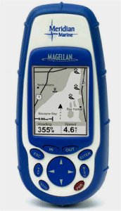
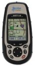
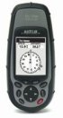
The Meridian Marine is one of
Magellan's newer range of handheld GPS Receivers. The Meridian range
are very rugged, built to last and are for the serious navigators in mind.
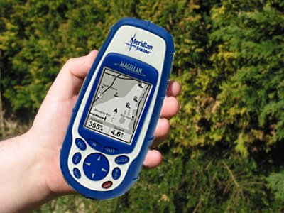
I have large fingers, and one thing I find with the Garmin receivers is that sometimes my
fingers are a little too large, the Meridian Marine, not only from a size
proportion, but it's buttons are better laid out and easier to press.
The Meridian Marine comes
standard with 16mb ram which includes a base map. The North America base map
includes US Cities, Interstate highways, political boundaries, major waterways
and airports.
The European version contains the same information except
the UK edition base map has UK Towns/Cities and major roads and motorways.
Like with Garmin, Magellan also offer an extra installable map CD called MapSend.
This allows you to upload and store these maps to the
Meridian with greater map detail than provided in the base maps. The Meridian
range comes standard with an SD slot allowing you to
use an 8mb, 16mb, 32mb or 64mb SD card. In fact, the only thing limiting
the storage capability is the size of the storage card that can be purchased.
Currently 512mb SD cards are available which could be used, giving you more than
enough storage space! The SD slot is located inside the battery
compartment, and you do need to remove the batteries to get to the SD card slot.
The SD memory card is optional and can be purchased from any computer store, or
direct from Magellan or a Magellan authorised reseller although the Magellan
store currently only ships up to 64mb cards.
The Meridian looks and
feels rugged, and reminds me of a dingy. Magellan do say the Meridian is
waterproof, I can see it certainly being splash proof, but there seems to be a
little bit of play on the back battery compartment when closed and locked, so I
wouldn't really want to submerse this unless I had to. It's sides are
rounded and rubberised and easy to grip, it has a large backlit keypad and a very large backlit
display which caters for large fonts.
|
|
 |
The Technology
Like many other handheld GPS
receivers, the Meridian Marine can track up to 12 satellites at any one time
out of the current constellation, and fully supports WAAS (Wide Area
Augmentation System) in the US and EGNOS in Europe. With current GPS accuracy, the
Meridian will be accurate within 3 meters or better depending on line
of sight to the satellites and the amount of strong satellite signals
the receiver has.
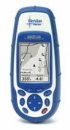
The Meridian GSP comes with 8 rich screens and 7 of which are fully customisable
which show satellite constellation, maps, compass,
Bearing/Heading screen, GPS Co-ordinate screen, Track screen,
Track details screen, and speedometer. |
|
The Bearing/Heading screens and Track
Screens give information like Bearing, speed, direction and ETA
options. The Meridian comes standard with support for up to 20
routes, 500 waypoints and up to 2000 track points which should be
enough for the average walker and supports 12 built-in co-ordinate
systems and 76 datums.
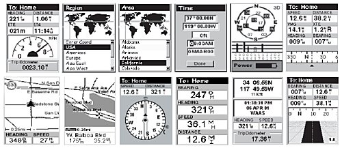
Screenshots from the Meridian GPS
If you're looking to use the Meridian
Marine for walks and hikes, you will certainly like the Track back
feature which is more accurate than Garmin's equivalent
system allowing you to accurately track back to each waypoint, which
makes it easy if you get lost and need to re-trace your steps.
Like many other GPS Receivers, the
Meridian also has compass support with Northfinder technology showing
you which direction is north no matter where you stand on the earth,
it also contains sun rise and sun set times and moon phase for any
date/location in the world. |
|
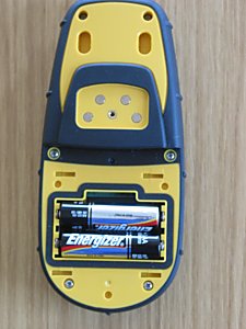
Back Cover
The back cover is locked into position
with two slider bars. Locked to the right and open to the left.
Once removed you'll find the battery
compartment which contains 2xAA batteries which are included in the
box. Remove both of the batteries and the small indent you see
above the top battery, contains the SD card slot. Once batteries
are removed you can insert or eject the SD card.
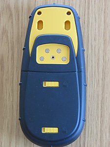
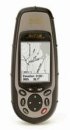
The PC/Pocket PC connection support on
the back I don't particularly like. You have 4 metal contact
plates and a screw |
 |
|
thread. You then have to match the
cable up exactly, and turn the screw head about a dozen times before
it fully locks into position. Although this does give a firm
connection, I much prefer Garmin's cable connections over Magellan's. You shouldn't have to keep screwing or unscrewing the
cable, but when you do it takes a while, where as Garmin's like many
plug/sockets are keyed and push straight on giving a tight connection.
The Meridian Marine will run for approx 15
hours of use on a set of 2xAA Batteries. |
|
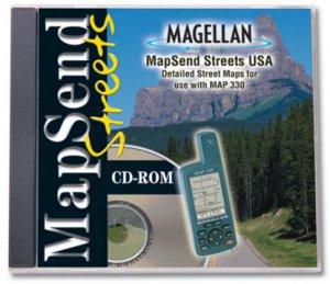 |
MapSend & DataSend Maps
MapSend
offers detailed street-level maps of the U.S. available in regional
files allowing you to download just the maps you need, saving memory
while making GPS navigation even easier.
The MapSend® Streets in the US CD-ROM contains highly-detailed maps
that can be easily downloaded from your PC to your handheld GPS
receiver for a fun and simple way to navigate.
Map details include streets, lakes, rivers, coastlines, parks,
hunting and fishing, railways and points of interest for the entire
United States. You choose the regions and level of detail to
download for maximum memory efficiency.
The data can then be updated or overwritten with new map regions.
|
|
Create your own waypoints and routes on your PC, edit and download
them to your GPS receiver for use on your adventure. Save thousands
of routes on your PC for recording your every journey. Plotting
your current position in relation to surrounding landmarks is fun
and easy, and your GPS search function will find street addresses
and points of interest, quickly and safely guiding you to those
locations.
MapSend is
currently available seven different flavours:-
-
MapSend
BlueNav Charts
-
MapSend
Streets & Destinations Canada
-
MapSend
Streets & Destinations in the US
-
MapSend
Streets Europe
-
MapSend
Streets in the US
-
MapSend
Topo in the US
-
MapSend
WorldWide Basemap
Magellan
also offer DataSend and DataSend Europe which allow you to create
your own personal charts. The unique DataSendTM Europe
software allows you to download your routes and waypoints from your
GPS receiver to your PC, to easily record your journeys and edited
them for future use on a new adventure. For use with your Magellan
SporTrak, GPS 315, GPS 320 or SP24 receiver. |
|
Comparing Handhelds
Pitting the Magellan Meridian GPS
against the Magellan SporTrak Map and the Garmin GPSMap76S, on a
windowsill which really doesn't pick up much of a signal at all, it's
good to see the antenna included within the Meridian is powerful
enough to match it equally amongst all three receivers. In-fact,
on several occasions I've received a stronger signal by 1-2 sats more
than the SporTrak Map!
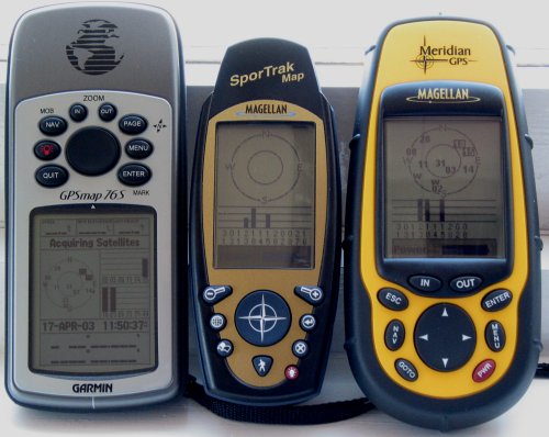
Garmin GPSMap76S, Magellan SporTrak Map
and Magellan Meridian GPS
One thing that makes the Meridian GPS
stand out is how rugged it is. It looks large here, but it
really does fit in the hand nicely and contains rubber armour, impact
resistant plastic allowing you to take the Meridian on any outing and
not having to worry about it being damaged and is waterproof sealed to
IEC-529 IPX7 specifications. The Meridian is also kitted out for
most European countries including language support for English,
French, German, Swedish, Finnish, Spanish, Italian, Portuguese and
Dutch.
All the Meridian's seem alike, what
are the major differences between them ?
|
|
|
 |
 |
 |
 |
 |
|
|
Magellan
Meridian GPS
|
Magellan
Meridian Colour |
Magellan
Meridian Gold |
Magellan
Meridian Marine |
Magellan
Meridian Platinum |
|
Basemap |
2mb cities/highways |
16mb cities/highways |
16mb cities/highways |
16mb cities/highways |
16mb cities/highways |
|
Colour Display ? |
Grayscale |
Colour |
Grayscale |
Grayscale |
Grayscale |
|
Barometric Altimeter |
No |
No |
No |
No |
Yes |
|
The main
differences between the Magellan range of GPS Receivers are shown
above. If you would like to see full comparisons, please take a
look at our Handheld Comparison
Review. |
|
GPS
Hardware TTFF (Time To First Fix)
| |
Cold
Test 1 |
Cold
Test 2 |
Cold
Test 3 |
Cold
Test 4 |
Cold
Test 5 |
Cold
Test
Average |
Warm
Test |
Hot
Test |
| CoPilot CF |
1m 22s |
1m 8s |
56s |
1m 17s |
54s |
1m 07s |
52s |
16s |
| Emtac
Sleeve/CoPilot |
40s |
37s |
42s |
37s |
46s |
40.4s |
10s |
9s |
| Emtac/Socket BT
GPS |
47s |
53s |
42s |
36s |
38s |
43.2s |
10s |
17s |
| Garmin
eTrex |
39s |
44s |
40s |
41s |
43s |
41.4s |
8s |
N/A |
| Garmin
eTrex Summit |
38s |
41s |
45s |
39s |
42s |
41.0s |
8s |
N/A |
| Garmin eTrex Vista |
37s |
57s |
32s |
35s |
38s |
39.8s |
17s |
N/A |
| Garmin GPSMap76 |
42s |
34s |
23s |
56s |
32s |
37.4s |
12s |
N/A |
| Garmin GPSMap76S |
32s |
53s |
32s |
39s |
36s |
38.4s |
11s |
N/A |
| Garmin
Geko 101 |
1m 37s |
45s |
38s |
44s |
41s |
53s |
15s |
13 |
| Garmin
Geko 201 |
34s |
45s |
38s |
43s |
40s |
40s |
19s |
10 |
| HaiCom 302 CF |
50s |
33s |
1m 25s |
36s |
1m 25s |
57.8s |
23s |
10s |
| HaiCom 303 MMF |
42s |
1m 05 s |
41s |
1m 02 s |
1m 18s |
57.6s |
36s |
3s |
| Holux GM-210 |
42s |
38s |
35s |
37s |
42s |
38.8s |
30s |
4s |
| Holux GM-270 |
54s |
1m 07 s |
1m 03s |
50s |
1m 12s |
61.2s |
39s |
4s |
| Holux GM-270U |
46s |
49s |
42s |
1m 01 s |
49s |
49.4s |
35s |
3s |
| Holux GR-230 |
1m 02s |
55s |
50s |
49s |
52s |
53.6s |
39s |
5s |
| LeadTek 9531
/ 9532 |
29s |
37s |
39s |
41s |
43s |
37.8s |
9s |
5s |
|
Magellan Meridian Range of GPS |
38s |
53s |
43s |
33s |
35s |
40.4s |
18s |
15s |
| Magellan SporTrak
Range of GPS |
37s |
47s |
46s |
41s |
41s |
42.4s |
19s |
16s |
| Navman 3000
(ROM 2.0.0) |
49s |
52s |
1m 33s |
3m 23s |
8m 5s |
2m 56s |
20s |
11s |
| Navman 3400/3420
(ROM 2.1.2) |
1m 33s |
2m 30s |
1m 32s |
52s |
1m 17s |
1m 32.8s |
20s |
12s |
| Navman 3450
(ROM 2.1.2) |
57s |
50s |
1m 09s |
48s |
1m 0s |
56.8s |
20s |
11s |
| Navman
4400 |
53s |
1m 03s |
1m 19s |
54s |
53s |
1m 00.4s |
0s |
0s |
| Pretec Compact CF |
1m 28s |
2m 47s |
57s |
45s |
1m 2s |
1m 23s |
1m 16s |
12s |
| Pretec Compact LP
CF |
3m 48s |
5m 32s |
4m 59s |
1m 53s |
4m 02s |
4m 04s |
52s |
33s |
| Rikaline X5 |
41s |
41s |
34s |
41s |
42s |
39.5s |
39s |
0s |
| Rikaline X6 |
34s |
60s |
44s |
48s |
57s |
48.6s |
38s |
0s |
|
RoyalTek Onyx |
1m 28s |
1m 39s |
2m 23s |
1m 38s |
1m 35s |
1m 46s |
1m 24s |
17s |
|
RoyalTek Sapphire RGM |
1m 02s |
1m 0s |
56s |
41s |
55s |
54.8s |
37s |
10s |
| RoyalTek RBT-3000 |
57s |
46s |
43s |
41s |
55s |
48.4s |
30s |
9s |
|
RoyalTek RGM-2000 |
48s |
52s |
40s |
45s |
39s |
44.8s |
33s |
7s |
| SysOnChip BT GPS |
48s |
77s |
66s |
67s |
51s |
61.8s |
37s |
4s |
| SysOnChip CF Plus (SIRFXTrac) |
40s |
30s |
33s |
38s |
39s |
36s |
30s |
0s |
| TFAC
MG30 Mouse |
1m17s |
1m 26s |
1m 38s |
1m 36s |
2m 11s |
1m 37s |
34s |
4s |
| TomTom
Bluetooth GPS |
48s |
52s |
46s |
59s |
51s |
51.2s |
37s |
3s |
| |
Fastest
TTFF
Cold
Tests |
Slowest
TTFF
Cold
Tests |
Manufacturer
Stated
Times
|
Warm
TTFF
Tests |
Manufacturer
Stated
Times |
Hot
TTFF
Tests |
Manufacturer
Stated
Times |
| CoPilot CF |
54s |
1m 22s |
Not Stated |
52s |
N/A |
16s |
N/A |
| Emtac Sleeve/CoPilot |
37s |
46s |
Not Stated |
10s |
N/A |
9s |
N/A |
| Emtac/Socket BlueTooth
GPS |
36s |
53s |
1m 20s |
10s |
45s |
6s |
10s |
| Garmin eTrex |
39s |
44s |
45s |
8s |
15s |
N/A |
N/A |
| Garmin eTrex
Summit |
38s |
45s |
45s |
8s |
15s |
N/A |
N/A |
| Garmin eTrex Vista |
32s |
57s |
45s |
12s |
15s |
N/A |
N/A |
| Garmin GPSMap76 |
32s |
56s |
45s |
12s |
15s |
N/A |
N/A |
| Garmin GPSMap76S |
32s |
53s |
45s |
12s |
15s |
N/A |
N/A |
| Garmin Geko 101 |
38s |
1m 37s |
45s |
15s |
15s |
13s |
N/A |
| Garmin Geko 201 |
34s |
45s |
45s |
19s |
15s |
10s |
N/A |
| HaiCom 302 CF |
33s |
1m 25s |
48s |
23s |
38s |
10s |
8s |
| HaiCom 303 MMF |
41s |
1m 18s |
48s |
36s |
38s |
3s |
8s |
| Holux GM-210 |
35s |
42s |
45s |
30s |
38s |
4s |
8s |
| Holux GM-270 |
50\s |
1m 12s |
45s |
39s |
38s |
4s |
8s |
| Holux GM-270U |
42s |
1m 01s |
45s |
35s |
38s |
3s |
8s |
| Holux GR-230 |
39s |
1m 02s |
45s |
39s |
38s |
5s |
8s |
| LeadTek 9531 /
9532 |
29s |
43s |
48s |
9s |
38s |
5s |
8s |
| Magellan Meridian
Range of GPS |
33s |
53s |
<2m |
18s |
<1m |
15s |
<15s |
| Magellan SporTrak
Range of GPS |
37s |
47s |
<5m |
19s |
<1m |
16s |
<15s |
| Navman 3000 |
49s |
8m 05s |
2m 0s |
20s |
48s |
11s |
18s |
| Navman 3400/3420
(ROM 2.1.2) |
52s |
2m 30s |
2m 0s |
20s |
48s |
12s |
18s |
| Navman 3450 (ROM
2.1.2) |
48s |
1m 09s |
2m 0s |
20s |
48s |
11s |
18s |
| Navman 4400 |
53s |
1m 19s |
n/a |
0s |
n/a |
0s |
n/a |
| Pretec Compact CF |
45s |
2m 47s |
1m 0s |
1m 16s |
45s |
12s |
8s |
| Pretec Compact LP
CF |
1m 53s |
5m 32s |
2m 10s |
52s |
45s |
33s |
20s |
| Rikaline X5 |
34s |
42s |
45s |
39s |
38s |
0s |
8s |
| Rikaline X6 |
34s |
1m 00 s |
45s |
38s |
38s |
0s |
8s |
| RoyalTek Onyx |
1m 28s |
2m 23s |
45s |
3m 0s |
45s |
17s |
20s |
| RoyalTek Sapphire
|
41s |
1m 02s |
45s |
37s |
38s |
10s |
45s |
| RoyalTek RBT-3000 |
41s |
57s |
45s |
30s |
38s |
9s |
8 |
| RoyalTek RGM-2000 |
39s |
52s |
45s |
33s |
38s |
17s |
45s |
| SysOnChip BT GPS |
37s |
77s |
45s |
37s |
38s |
4s |
8s |
| SysOnChip CF Plus (SIRFXTrac) |
30s |
40s |
45s |
30s |
38s |
0s |
8s |
| TFAC MG30 |
1m 17s |
2m 11s |
45s |
34s |
8s |
4s |
0.1s |
| TomTom Bluetooth
GPS |
48s |
59s |
45s |
37s |
38s |
3s |
8s |
|
|
Connecting the Magellan to a PC or Pocket PC
Magellan ship a PC data cable in all
their GPS Receiver boxes so you can connect the Magellan GPS Receiver
to a PC which has a DB9 (9 pin Serial) connector. These are
pretty much standard on all computers, except some newer computers
tend to favour USB or Firewire over Serial.
You can also connect a Magellan GPS
Receiver to a PDA like a Pocket PC or Palm PDA. You can do this
by purchasing a cable set from
PC-Mobile. The
cable should comprise of two parts, the first part is the cable that
screws onto the back of the Magellan like the one below.
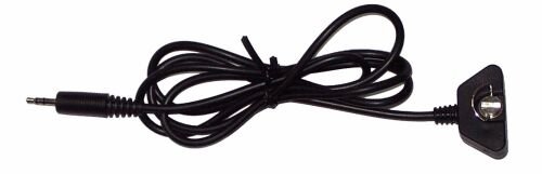
The second part of the cable will have a
3.5mm socket on one end which will connect with the 3.5mm plug (left)
and the other end of the cable will have a PDA connector. This
then allows you to use your favourite GPS Receiver on your favourite
PDA and utilise a whole host of other mapping products anything from
Topographical products like Fugawi, OziExplorer, Memory-Map to Street
Routing software like TomTom Navigator, PowerLOC Destinator and you
don't then need to purchase a second GPS Receiver if you're primary
use going forward will be on the Pocket PC! |
|
Summary
The Magellan
Meridian Marine is a great GPS Receiver, and one I'm having trouble
putting down. The receiver has all the standard features that
you'd want in a handheld GPS Receiver, it fits into the hand neatly
and you just feel at home with it.
|
|
|
 |
 |
 |
 |
|
|


