Home PageFacebookRSS News Feed
PocketGPS
Web
SatNav,GPS,Navigation

The GiSTEQ PhotoTrackr image tagging system review

Date 7th December 2007

The GiSTEQ PhotoTrackr system allows digital pictures to have the location that the image was taken embedded in the image file. This is a complete package which includes a GPS datalogger and the software to match the date and time an image was taken to the recorded trip log. This process is known as geotagging or georeferencing.


This year I have reviewed a number of digital image geotagging systems all of which have been very much focused on the hardware with the supporting software an (often poor) afterthought. Not so with the GiSTEQ PhotoTrackr. This is a software package that just happens to use a GPS datalogger. This is very apparent when you install the software and look at the workflow.


The system is priced at around £50 or $99 and is available through Amazon and Expansys.


As this is a software centric system we will start with the software and work our way round to the hardware. Installing the system is simple: just pop in the CD and let the installer run. When you first run the application you need to obtain an API Key for Google Maps. This takes you off to Google to get the code, but don't worry it is really easy to do. As with most software you will also have to activate it.


Unfortunately GiSTEQ only offer a Windows version of the software leaving us poor Mac users having to run it in a virtual machine. I use Parallels on my MacBook Pro, but I haven't been able to connect to the GPS.


Essentially the software looks like the developers have created the system from a multi-user data recording point of view. The system comes with a default database pre-installed, this contains some default users. I deleted these and added my own name as a user. If you have a lot of users you can add lots of different data such as phone numbers and addresses.


Article by Mike Barrett


The GiSTEQ PhotoTrackr image geotagging system review

Once you have the user configured you can then register the GPS to a specific user. This is where the business aspect of the system comes to the fore. It would be ideal for use in a real estate business. Each of the staff could have their own GPS and then when visiting new properties the images will be associated with that particular agent. These would all be managed on a single computer in the office.


The GiSTEQ PhotoTrackr image geotagging system review

OK with the software all ready the only thing that remains to be done is to synchronise the camera's time settings to those of the GPS. This can be quite fiddly to attempt to do manually, but don't worry help is to hand.


GiSTEQ have provided a wizard to guide you through the process. First of all you need to go outside and switch on the GPS, waiting until you have a good "Fix". Then bring the GPS indoors to the computer and follow the rest of the wizard's instructions. This will show you the time to set on the camera.


The GiSTEQ PhotoTrackr image geotagging system review

Now that the system and camera have been set up you are ready to go out and have some fun capturing your favourite scenes, people, or whatever takes your fancy. All you need to do is to make sure that your GPS is fixed (red light flashing) for at least 1 minute before you capture that perfect image...


I tend to get to a location for shooting and then switch the GPS on. By the time I have set up the tripod and set my camera up the GPS is normally fixed. I recommend ensuring that you have had a fix for at least a minute to make sure that any minor differences in time setting between GPS and camera are eliminated.


If you are out for a whole day of sightseeing then just switch the GPS on and leave it with a clear view of the sky. I normally have mine attached to the camera bag which is always close to where I shoot the picture.


The GiSTEQ PhotoTrackr image geotagging system review

So you have been out for the day and have taken dozens of pictures... What do you do now?


The first thing is to get the GPS Datalog into the computer. This is really simple, you just connect the GPS datalogger to the computer, hit the trip records button and select the Download Trip Record option. This displays the dialog to the right, allowing you to re-assign the track to a different user, and download the data into the PC.


By default the tracks are stored in the LogFiles directory in the GiSTEQ PhotoTrackr program file directory.


The GiSTEQ PhotoTrackr image geotagging system review

Once the track is loaded you can now import the photos.


Make sure that the camera or memory card is connected to the computer, and then hit the "Add Images" button. Navigate to the folder with the images in and then the import will start.


You will be asked if you want to update the images with the GPS position information. You can either do this now or later. Be aware that adding the GPS location will update the image file, and although it is very rare it is possible that something could go wrong when modifying the file and corrupt the image. I would always recommend making a backup of the images before running the PhotoTrackr import.


If your pictures are on a camera or memory card you will also be asked if you want to copy the images to your hard disk. I generally tend to leave mine on the store card. (I also don't take my own advise about taking backups...). This tends to work better for my workflow and does not leave images scattered all over my storage systems. When you get 4 or 5 copies of a 6MP image on the disk it doesn't take long to fill up your available space.


The GiSTEQ PhotoTrackr image geotagging system review

Once you start collecting hundreds (or in my case thousands) of pictures it can start to get a bit difficult to organise them. The PhotoTrackr gives you the opportunity to assign the images to a group. Groups have titles, dates and descriptions associated with them.


Although the group facility is good it is not searchable and after a number of photo trips will start to get a bit cluttered. I think some thought needs to be put into this area if you intend to use PhotoTrackr as your sole method for organising your images.


Having selected the group, date and description you will then start to import the images. It can take some time to import your pictures depending on the number of tracklogs you have saved.


The GiSTEQ PhotoTrackr image geotagging system review

The image date and time stamps are used to determine where on the recorded GPS data track the picture was taken. This is where the importance of synchronising the camera and GPS is of paramount importance and will save time correcting after the images are loaded and tagged.


If you do make a mistake with your timing you can still re-analyse the tracks and reset the location. I managed to be exactly 1 hour out when the daylight savings changed. Initially I thought it was going to be a big problem, I had about 100 pictures all out by one hour. It was interesting to see how far we moved in that time. To correct this all I needed to do was highlight the pictures and then right click and take the "re-analyze Image Location" option. This allows you to set an time offset between the logger and the timestamp on the picture.


It certainly saved my skin, I did a Synch Camera Time after that. So just beware when the transition to daylight savings happens.


The GiSTEQ PhotoTrackr image geotagging system review

Now that the pictures are in the system you can examine each one individually by selecting the group and then selecting an image within the group.


This will link to Google Maps in the lower pane and show you exactly where the picture was taken. Once you have verified one image the rest of the batch should also be correct.


You can now go through each of the images and assign a title and description to them. This will be used later in the workflow when exporting the pictures.


You can close the top pane and then move around the google map browsing thumbnails of the images in a Google popup by clicking on the image placeholder.


The GiSTEQ PhotoTrackr image geotagging system review

Click here for full sized picture

Exporting Pictures

So the pictures have been geo-tagged and saved, but what can you do with them now?


Well obviously you can use the facilities built in to the PhotoTrackr, but this is for your own personal use. It doesn't allow you to easily share your pictures with your family and friends or even the rest of the world.


The guys at GiSTEQ have given this a lot of thought and by clicking on Logger Settings and selecting the Software tab you can select one of the popular Photo sharing community sites. When you supply your user name and password the PhotoTrackr can upload the specified images to the selected community portal.


My current favourite is is Picasa, from Google. It is easy to signup for an account, and then the integration is built into the PhotoTrackr application.


Each picture can have a title and a description. The interface to Picasa only uses the description so don't waste any time editing the title unless you want to.


The export is a really simple operation. All you need to do is highlight the images that you want to transfer, then hit the "Share Online" button. For Picasa this allows the selection of Album to post to (it doesn't allow you to create a new one though) and the security of the images i.e. who is authorised to view them. There is also an opportunity to resize the images as you transfer them.


Once the transfer is complete they are available for authorised people to view. I have posted a small section of my test images to a public Picasa album. Click here to see the capabilities of the Picasa system. I have linked to my favorite view of the album, the map... If you click on an image it displays a thumbnail and moves the map to the location. You can then press play and get a slideshow of the images in the album.


If Picasa is not your choice then the PhotoTrackr software also has export capabilities for Flikr, Locr, and SmugMug. If none of those suit you then you can still export the geo-tagged images as graphic files.


The GiSTEQ PhotoTrackr image geotagging system review

The GiSTEQ PhotoTrackr image geotagging system review

The GiSTEQ PhotoTrackr image geotagging system review

The GiSTEQ GPS Datalogger

Finally we come to the GiSTEQ GPS Datalogger hardware.


The datalogger is based on the Nemerix GPS chipset, and claims 32 hours of operation from a single charge. It has 4Mb internal memory which is capable of storing up to 250,000 trackpoints.


The datalogger also includes intelligent power management with auto on/off. It incorporates a vibration sensor that detects when you start moving and can turn the GPS on. This extends the operational time, with the software allowing images to be tagged with the last known active location.


The datalogger can be used as a GPS mouse with a serial cable, or as a Bluetooth mouse (if you buy the CD110BT model). This allows you to plug into a laptop or PDA and use the GPS data for navigation or any other application requiring NMEA 0183 input.


As can be seen from the picture to the right the GPS has a number of buttons and indicators. The buttons on the left and right adjust the volume, the one in the centre is the manual on/off. These also double up as indicators, with all sorts of flashing colours. At night time whilst driving it is like a mobile disco. I have seen red, blue, green and orange flashes.


I have found that the datalogger is reliable. It is not as sensitive as some of the other chipsets, it takes longer to get a fix, but once it has got a fix it seems to stay fixed well, and not give many false positions. Testing in San Francisco had good accurate GPS fixes throughout even in the downtown area in urban canyons.


The GiSTEQ PhotoTrackr image geotagging system review


The GiSTEQ PhotoTrackr image geotagging system review

In fact while testing a similar device in New York I found that the chipset took a long time to get a fix, and then it retained it well. When the signal was too weak the GPS didn't report a position. One of the competitor chipsets I was testing on the same day was telling me I was over 2 blocks away... I would rather have the accurate position than an bad approximation.


One unique feature of the GPS is that it talks to you. Yep, when you start it up it says: "Satellites positioning". When it gets a fix it says: "Satellites Fixed". this caused a bit of amusement wandering around London in and out of buildings and underground stations when my camera bag started talking to me...


Fitting into my digital workflow.

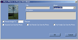
Everyone has their own way of working and has tailored a sequence of tasks to achieve that workflow. I have a Mac and use the Apple Aperture application as my main repository for my digital images. Aperture allows me to make adjustments to the image such as contrast, levels, colour saturation etc, as well as the typical cropping and rotation/alignment tools. The dilemma I face is how to get the images pre-processed before plugging them into PhotoTrackr to geotag them, and upload them to Picasa.


I actually do it the painful way. import the originals into Aperture, do my selection and photo finishing in Aperture/Photoshop, export the finished images, import them into PhotoTrackr this adds the location to the images, I then export the finals to Picasa and re-import them back into Aperture.


The other option I sometimes use is to import the originals into PhotoTrackr, Geotag them, then import the Geo-tagged images into Aperture, do my photo finishing in Aperture, export the finals back into PhotoTrackr, after deleting the originals.


Neither workflow is ideal, but I do end up with properly georeferenced images that I can use in a number of applications.


Issues

While I was testing the application I came across a number of issues/problems, most of these I have already mentioned, but will summarise here. I didn't regard any of these as critical.


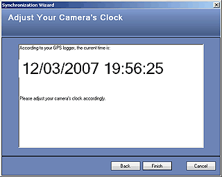
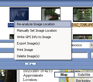
1) Time synch of camera and images. This was my biggest problem, not a problem with the system but more a user error. Somehow my camera was an hour out when the daylight savings time ended. I had over 100 images with the "wrong" time on them. Fortunately I was able to re-analyse them and get the correct time synchronisation.


2) No basic edit features. A lot of my pictures are taken in portrait mode rather than landscape. This results in the image being 90 degrees out. There is no way to correct this other than pre-processing the images so that they are all the correct orientation before importing them into PhotoTrackr.


3) Backup of data. There is one critical file which contains the internal application database for some reason I managed to corrupt this file which meant I lost all my settings. Fortunately I was able to rebuild the important items such as the tracklogs and picture libraries, but it was somewhat inconvenient. GiSTEQ have taken this onboard and are considering a solution.


4) Limited organisation and search capabilities. As your image library builds up it will become increasingly more difficult to manage. I appreciate that PhotoTrackr is not an image library application, but it does mean that you cannot have a single application to manage all your image needs.


5) No Mac support!! I suppose it is not a big surprise that there is no Mac support, but the traditional Mac user has always been seen as "graphical". There is a huge market out here for this sort of Mac enabled application, maybe with direct plugins or integration to Aperture or iPhoto.


Conclusions

It is obvious from the system that this has been developed from a software system point of view rather than a hardware manufacturer adding some functionality with software add-ons. The whole system works very well, and is the best one I have tested to date.


There are a lot of well thought out features which integrate well to provide a very good solution. I would like to see some basic editing functions (especially picture rotation) built in to avoid having to preprocess images.


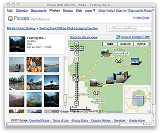
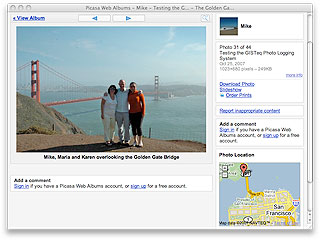
This is an innovative and embryonic application of GPS technology that I believe will develop dramatically over time. The integration into image sharing community sites is possibly one of the best aspects of this software, enabling Georeferenced Photo Blogging to be achieved with a minimum of fuss.

References

Manufacturers Website

www.GiSTEQ.com

www.picasa.com

Pocket GPS Contributor

Mike Barrett

Pocket GPS Contributor Website

www.Pocketgpsworld.com


Comments ?

Have any comments about this review ? Post them here.

CamerAlert Apps


iOS QR Code


Android QR Code


© Terms & Privacy

GPS Shopping