|
Garmin Nuvi 1690 Review |
29th January 2010 |
|
Review by Matthew Morley (MaFt)
Shortcuts: Introduction | Mapping | Construction and Installation | Menu Navigation| nuLink |
Main Menu & Bluetooth | Navigation | Missing Features | Extras | Round Up | Conclusion | Links
Tip: click on any of the images for a larger version!
Introduction
 It's been a long time since I used a Garmin so I thought it would be interesting to see how they've come on since February 2008 when I reviewed their (then) flagship nuvi 710. The nuvi 1690 is Garmin's current top of the range device and is the focus of this review. I also have a nuvi 1490T and nuvi 1240 that will be reviewed in the near future.
So, what do we have with the 1690? The main feature is the addition of the “nuLink Real-time Services”. Put bluntly, this is Garmin's answer to TomTom's Live Services – I will stress, however, that this is a review of the nuvi 1690 rather than a comparison with the TomTom x50 series! Regardless, I don't have a 950 to compare it with anyway! I'll cover nuLink in more detail later on.
Mapping
The 1690 comes with NavTeq's Western and Eastern European mapping which covers 33 countries at street level and an extra 7 with major routes only. The settings pages state it is ©2009 NAVTEQ but there's no specific detail as to which quarter the maps are from. It is also compatible with Garmin's cityXplorer maps but these are available to purchase separately.
Construction and Installation
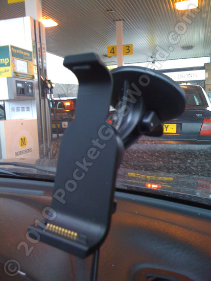
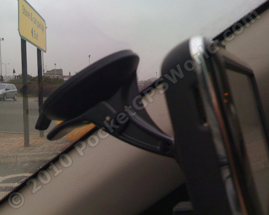
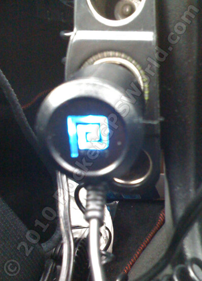 Included in the box is the standard windscreen mount and a rather snazzy power lead. I know it's not much but the addition of a blue LED and a square-spiral does it for me. The device itself has a nice gloss black face along with a silver trim – a couple of nice little design touches. The back of the device is a slightly rubberised plastic which aids in keeping a grip when installing or removing. The power lead is a normal mini-USB connection so is cheap to replace if needed. It also fits directly into the mount which allows for faster removal of the device. Admittedly it also means that it takes longer to remove the mount itself but you could always leave the power lead attached when it goes into the glovebox / bag / house. The windscreen sucker is strong and provides a good, solid base that is free from the wobbling and shaking caused by vibration and potholes.
The touchscreen does not feel overly responsive. Initially I had some trouble pressing buttons near the edges of the screen but after a tip-off in the forums I recalibrated the screen by holding the top left of the screen for 30 seconds while powering up the device. After a game of 'press the target' the screen was recalibrated and the device did a better job of activating buttons where I pressed on the screen! Even after calibration I find the peripheries to be slightly less sensitive (i.e. press harder near the edges for touches to register) and when using the on screen keyboard I often have to resort to using a finger nail in order to get the correct letter.
As with all Garmin devices I have used, the battery life is excellent. You can leave it in a drawer for a week or three and still power it up to check POIs or prepare a route after that. It is perfectly feasible to use it for a relatively long journey (4 hours plus) on a single, full charge.
 Menu Navigation
For a while now Garmin have used 'scrolling' menus whereby you can move between screens either by pressing the up/down buttons or by sliding the screen up with your finger. You need to press the screen quite hard otherwise it will register as pressing a menu item. Perhaps I am used to the smaller, more responsive mobile phone touch screens? Personally I generally use the up/down buttons unless there are a lot of screens to move through.
After selecting a menu item the next screen slides in from the right and when you use the 'back' button it slides back out to the right. It may be rather cheesy but it works well and is actually a nice touch to the user interface without bogging it down.

nuLink
I've already mentioned in passing that the 1690 features Garmin's nuLink services so here is a bit more information about what they actually are.
Hot Traffic
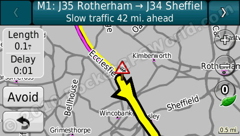
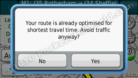
Instant traffic updates which “uses live data from various suppliers across Europe including Traffic Master for the UK”. This seems fairly accurate as far as I can tell and the integration is well handled. You can overlay the current traffic information onto the map while navigating or choose from a list of 'events' to see a close up map along with details. If traffic on your trip is fine you get a green icon but as new traffic incidents are received this status colour can change. For example if it picks up slow traffic it will turn amber and also display the estimated delay. Pressing the icon will then allow you to view the details and also avoid it if you wish. The 1690 will ask you to confirm that you want to avoid the traffic if avoiding it won't make the trip any faster.
Fuel Prices
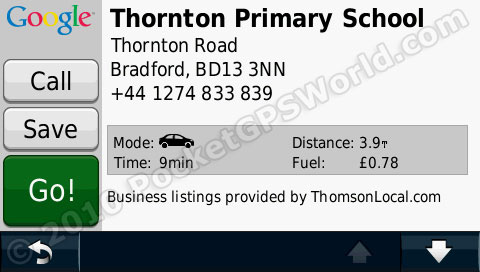
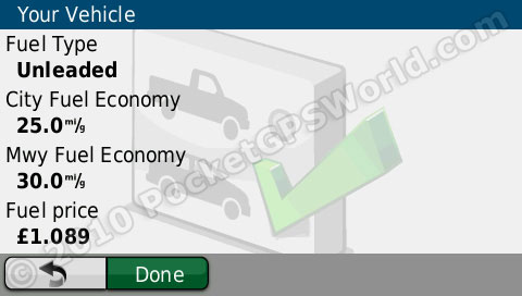
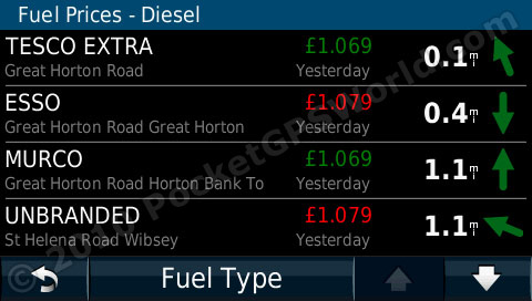 Initially I wondered why the Fuel Prices were found under the 'Where To?' menu but I soon realised why... The assumption is obviously that you only care about fuel prices when you want to go and buy fuel! The prices for my local stations were accurate and it also informs the user of the date the information was last updated. The cheaper prices show in green whereas the more expensive ones are in red. Note that it is not the cheapest shown in green, but the two lowest prices. You can also easily switch fuel types (super unleaded, regular unleaded, super lead replacement, super diesel, diesel and LPG). Fuel prices are not available in Italy, Germany or Belgium.
 Google Search
The Google search works well and you can either filter by a preset category or type in your own search. With the preset options it does make me wonder why the Google results are not simply merged with the inbuilt POIs perhaps with a marker to say it is a Google Search result. At present if you search the inbuilt POIs to no avail you then go back to the Where To? Menu and try a Google search instead – an extra step that could be removed.
Weather Forecast
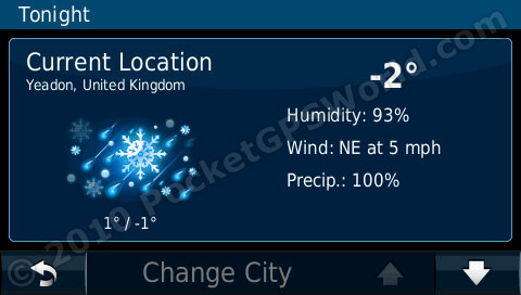 The weather shows you the weather at your
current location and also allows you to 'store' 3 other cities that you can view the weather for. Pressing the forecast then moves you to a 5 day forecast. Unfortunately there does not seem to be a way to set one of the preset cities simply as your 'Destination'. Instead, you would need to manually add your destination city to view the weather.
 Currency Exchange
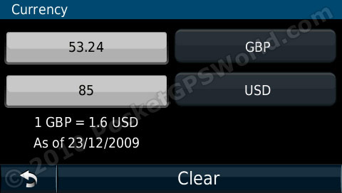
The most recent exchange rates are automatically downloaded to the device and then you simply select your currencies and the amount you wish to convert! This is only let down by there being 33 pages of available currencies and no text search to filter the list down. United Kingdom and USA are on page 32 and pressing the 'down' arrow 32 times isn't fun and, as the 'flick to scroll' isn't as sensitive as it could be, it can get rather frustrating! You can also create a custom exchange rate if needed.
Phonebook
The Phonebook (or White Pages in some countries) allows you to search by last and first name to find an address you can navigate to. The UK data only seems to have initial instead of full first name. Bizarrely for both my name and my Dad's name it only gives the house number and not the street name – the majority do show the street name though! Also, for a phonebook, it seems odd that you cannot phone the number directly. From what I have gathered from reading some American reviews of the 1690, the White Pages allow you to enter a phone number to get a reverse lookup for an address. This does not work on the UK 'Phonebook' version.
 Advanced Speed Cameras
Garmin take advantage of the 1690 being a 'connected device' by auto-updating their speed camera database. However, there is no information on the device to say when they were last updated or even when they are being updated. I won't comment on the quality of the database as last time I did I wasn't very popular with Cyclops, their data provider... You need an active nuLink subscription to keep your database up to date although you can always use the PocketGPSWorld.com database.
Ciao Friend Finder
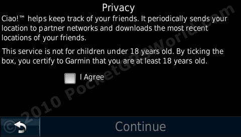 I apologise for the lazyness of this section; here is the PR for the Ciao Friend Finder: “The nüvi 1690 is also Garmin’s first mobile navigation device to transform traditional social networking into location-enabled social networking. Through Ciao!, customers have the option of sharing their whereabouts with friends and family. Ciao! users will see their friends’ location on a map and then be able to navigate to that location. Ciao!, is a patent-pending social network application that links multiple location-centric social networks onto one application, Ciao! currently aggregates information from GyPSii and uLocate’s Buddy Beacon social network services. Ciao! is expandable and additional social network partners are expected in the future.”
I don't use or know anyone who uses GyPSii so I could not test this feature. Sorry!
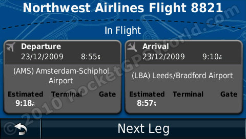
Flight Status
This feature shows your nearby airports (or you can search around a specific area) and allows you to view the current flight status. Simply select the airport and enter a flight number for details. You can also search all arrivals and departures by destination or airport code.

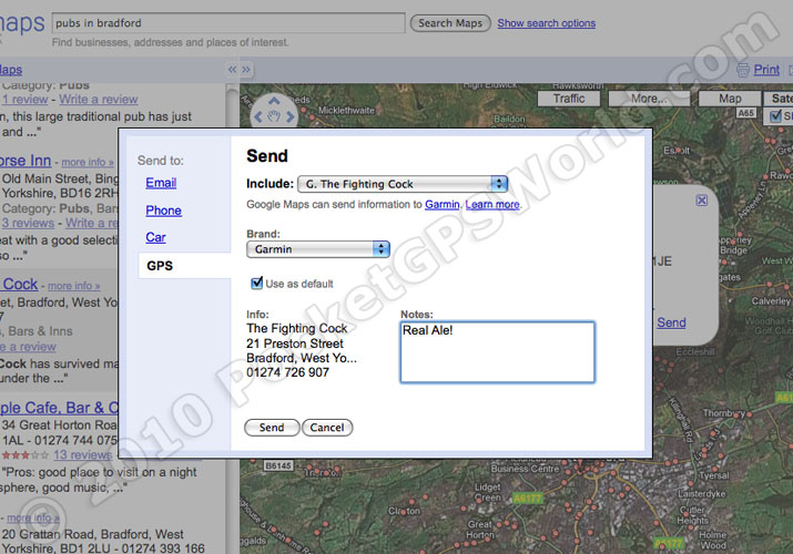
Send to GPS
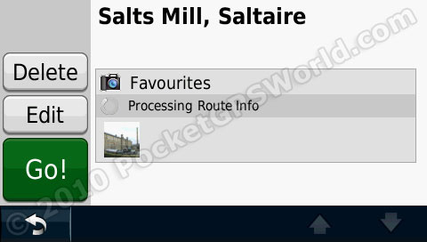
“Send to GPS allows you to search the Google Maps website for any business address then transfer that address wirelessly to your nüvi 1690. The point will be saved as one of your Favorites, and you can navigate to it or view it on a map.” And, what can I say? It works a treat! In Google Maps (and other sites that make use of the Garmin Communicator Plug-In) you can select the 'send to GPS' option which then forwards you to a specific Garmin page where you can add some details if needed. You have a choice of transfer by USB or wirelessly (or via MSN Direct in the USA) – you must have your device registered with Garmin for the wireless transfer but this is a simple process anyway. To be honest, for businesses it's easier to use Google Local Search on the device and then save it as a favourite. You could, however, also use it for friends addresses to add as favourites etc – not just businesses. Sending it over wireless added it to the favourites very quickly although there was no confirmation pop-up screen or message in the myGarmin folder.
Panaramio
If you head over to http://connect.garmin.com/photos you can find geotagged photos from Google's Panaramio feature. You can then select up to 50 per day to download to your device. This will only transfer via USB and not over-the-air as the 'send to maps' feature does. You can then navigate to these photos (usually tourist-type POIs) by finding them in your Favourites folder.

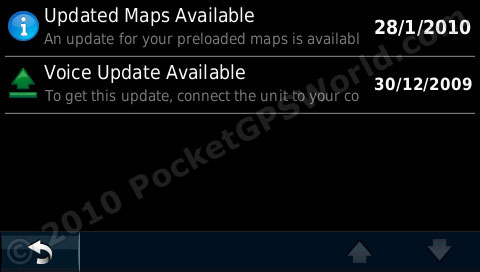 MyGarmin
This 'folder' is an inbox for system messages from Garmin such as when new firmware, maps or voices are available. You can't download the updates over-the-air but it is more convenient than checking every-so-often with the Garmin Updater software.
Traffic, fuel and some other services are available across 15 countries (Austria, Belgium, Denmark, Czech Republic, France, Finland, Italy, Germany, Netherlands, Norway, Poland, Spain, Sweden, Switzerland, United Kingdom) with 2 others, Russia and South Africa, planned in the near future. The 1690 uses Dutch mobile carrier, KPN, to allow the pan-European services.
The device comes with an initial 12 months subscription and after that it costs £69.99 / €79 per year. However, as the safety cameras are updated over the air, once the subscription expires there are no more camera updates (unless you use the PocketGPSWorld.com database). Basically, if you plan on keeping this device for over a year then you should seriously consider how much you will use the nuLink services and whether they are worth the subscription. The device RRP is £349 (realistically you would pick one up for £300) so each year you have 25% of the original purchase price to pay to keep the features. I did receive a cryptic email from Garmin's PR stating that there are “2 free connected services” although I never got a response as to which services do not require an active subscription.
As a side-note, the American version of nuLink also offers the White Pages (which allows reverse lookup so you can enter a phone number to find an address), movie times, local events (concerts, theatre etc) and the device comes with a 2 year subscription (as opposed to the European 1 year offering). However, the American version is Ad-Supported – when you stop, eg at traffic lights or at your destination, then adverts will pop up on the screen and can sometimes include discount vouchers. There are no adverts on the European version.
Main Menu & Bluetooth
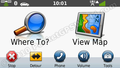
I still like the simplicity of Garmin's now familiar home screen; we first saw this on the nuvi 200 series which were advertised as being “so simple you're gran could use one”. It obviously is and it still works well even in their top of the range device. The screen is made up of two large icons for 'Where To?' and 'View Map' and then a row of smaller buttons along the bottom for the settings: Phone, Volume and Tools. If you get really stuck then the 1690 has on the first page of the tools menu a 'Help' option - this is essentially a simple, on-device, user manual.
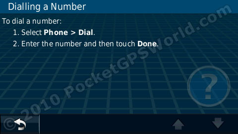
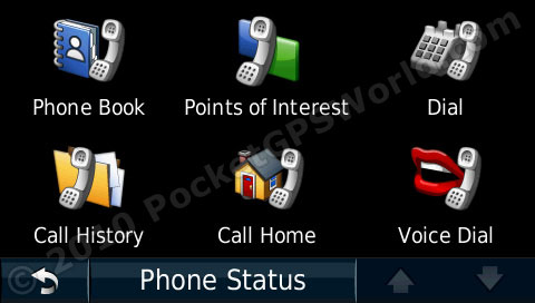 Pairing my mobile was nice and straight forward (Settings / Bluetooth) although I was slightly concerned that it hadn't copied over my phone book. After a moment the Call History was available but it took a good few minutes for it to show my phone numbers. A little pop up would have been nice to 1) say that transfer of the phone numbers had started and 2) to say it had finished. I almost gave it a black mark for not having my numbers available! The 'voice dial' option is available regardless of whether or not the phone is compatible – mine isn't so I'm unable to test it for this review.
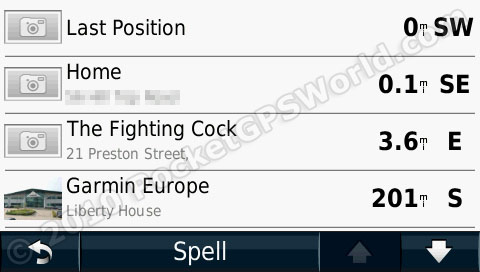
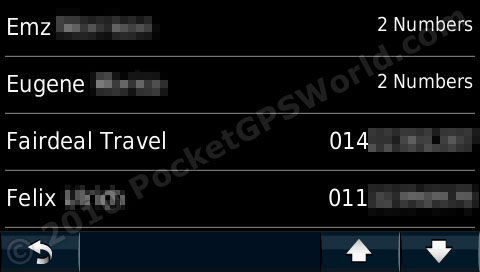 The Phone Book is a big issue for me. The nuvi 710 I reviewed previously had a 'spell' function so you could quickly filter your contacts and speed up the process. The 1690 seems to be a step backwards – Garmin have removed the 'spell' button so you must either press the down/up buttons repeatedly or use the 'flick to scroll' method – which only moves screens at a time. You can, however, press and hold the up/down buttons but with four contacts per page it can take a long time still to get to 'T'. It also gives you a loud 'beep' each time it moves page – this gets very annoying when scrolling such long lists.
Within the settings you can access all the usual: route preference, avoidances, units, time, language, voices, proximity alerts etc. To be perfectly honest there's little really to write about here... You can change a range of settings; that's all you need to know!
Navigation
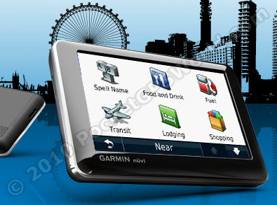
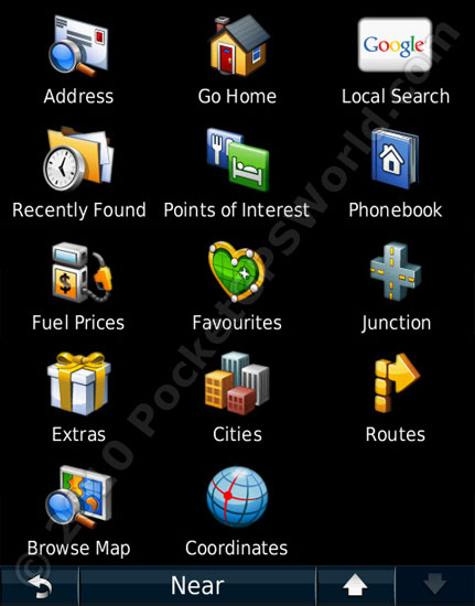 Pressing 'Where To?' takes you to your route set up screen. From here you can search for your destination in the form of: address (including full 7 digit postcode), go home, Google search, recently found, points of interest, phonebook, fuel prices, favourites, junction, extras (such as 3rd party POIs), cities, routes, browse map or coordinates.
The built in POIs are quite extensive but, as with all inbuilt POIs, can vary wildly in accuracy. Luckily, Garmin have their POILoader software and the 1690 is compatible with our POI downloads available from this link. Going to Tools then Where Am I highlights this. Apparently there are no police stations in Bradford... Hospitals and Fuel are accurate around my area though. While I'm on the subject of the 'Where Am I' function it's worth mentioning that the Roadside Assist is quite useless unless you are in the AA. It simply just shows the AA's contact number. A brilliant feature, in my opinion, would to be the facility to add a user-defined company along with contact details and a field for your policy number should you ever need it. The software development team can have that one for free!
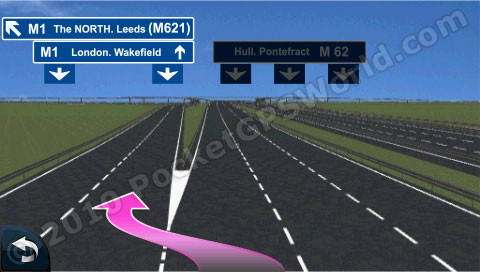
The routes given were sensible and calculated in good time. Instructions are given in a timely manner with enough warning before each one. The 'reality view' on motorway junctions works well and it's easy to see which lane to be in. I had a few issues, mostly at motorway junctions, where the 1690's screen seemed to freeze – the map simply didn't update. Had I not known which turning to take after coming off the motorway I would have been very annoyed. A freeze, at the best of times, is bad; it is particularly worse if it occurs at a busy junction like turning off a motorway. The two occasions when this happened I was turning off a motorway so my assumption is that it does not cope well with auto-zooming in where there are a lot of roads nearby and it also has to give directions. Unfortunately this happened a few times so seems to be a device issue as opposed to a one-off glitch.
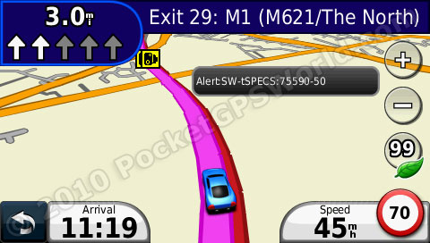
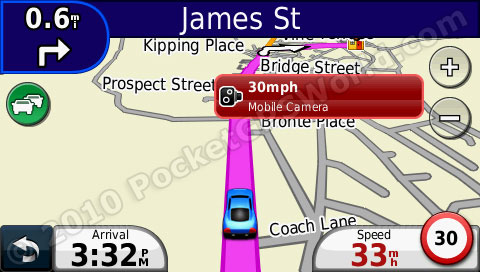
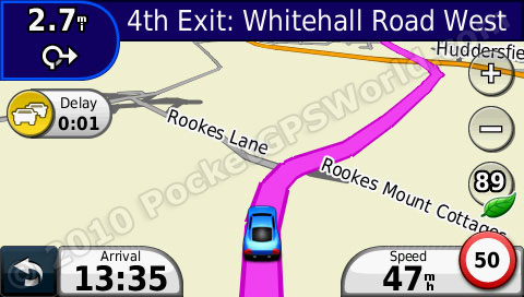
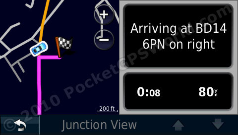 The speed limit is always shown in the bottom right of the screen next to yours. These were very accurate and only a few of the roads I travelled on were missing their speed. If you go over the speed limit then your speed is shown in red although there are no audible warnings for this. Pressing the map at any time takes you to the 2D overhead view where you can save your current position as a favourite. Pressing the 'Next Turn' arrows at the top takes you to 'Junction View'where you can scroll through a list of all the turns to your destination; this is useful for quickly reviewing your trip.
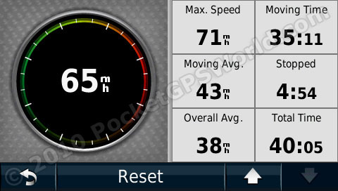 While navigating you can press 'Arrival Time' to bring up an option of what to show in the bottom left of the screen. You can choose from ETA, distance, time to destination, direction of travel, elevation. Also, your next turn is shown in top left and speed always shown - on older devices the speed was hidden while navigating. Pressing your speed to bring up trip computer where you can view your top speed, average speed, fuel usage and cost etc.
The 1690 allows for 'multi-point routing' and it is relatively straight forward to do this. You can either go to your Routes in the settings and add a new route or if you already have a route set then you can use the 'Where To' option and choose to add it to the existing route. You can then manually rearrange the waypoints or set the start and end and use the optimise function. It can be slightly frustrating that you need calculate the route first and then save it in order to then choose to optimise it – having an 'optimise route' option after adding all your points would, in my opinion, speed things up a little. It does work though!
 The traffic alerts seemed to work well although it's one of those things that's practically impossible to test 100%. If I reroute around traffic then how do I know there really was a traffic jam if I didn't drive there? So, I ignored the warning and got stuck in traffic... But then, had I re-routed would it have been any quicker? This isn't a Garmin-specific issue but one that affects all devices with traffic warnings. At an absolute minimum it's nice to be pre-warned that there will be delays on your route!
Missing Features
Now, this section may seem slightly odd – why review something that isn't in the device?! Well, I like my music and I like it at a volume where I can hear it when driving down the motorway in my clapped out Rover 25 (it doesn't have the best sound-proofed interior!); as such I often make use of the headphone socket and mix the voice instructions with my stereo's music or use an inbuilt MP3 player and have music and guidance sent via the FM-transmitter. Now, in the nuvi 710 I could do either of these but the new flagship model removes all three of these – the 1690 has no headphone socket, no MP3 player and no FM Transmitter so you literally only have the built in speaker. On normal roads the volume is adequate but as soon as you factor in the extra noise of motorway driving and music then it can, at times, be hard to hear. It is a rear-facing speaker which I presume, like with other manufacturers, is to allow natural amplification from the window. I do want to just reiterate, though, in most cases the volume is adequate and is, in no way, quiet!
Extras
 The nuvi 1690 also has the now-obligatory photo viewer, unit converter, world clock and calculator – does anyone actually use these?! It also has a micro-SD (transflash) slot for map updates and for use with the photo viewer. Now, forgive me if I am missing the obvious here but practically all digital cameras that use SD cards use full size SD – I've not seen one that takes micro-SD. So in order to view photos on the device you would need to transfer the pictures to a different memory card via a computer anyway; so why not just view them on the computer? A full size SD card slot would allow users to simply move the card from camera to satnav to be able to view them on a bigger screen. Admittedly you could get a full size card adaptor for a micro-SD card but would most users be bothered? As such I feel that the photo viewer on the 1690 is pretty pointless.
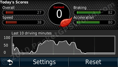
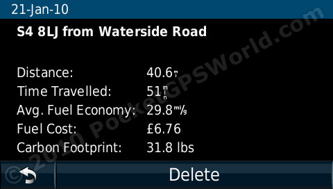
 Garmin's relatively recent Eco-Route can be quite interesting at times. I don't mean 'interesting' in a derogatory way either, it is genuinely interesting. The idea is that you set up a brief profile of your vehicle consisting of the fuel type, fuel efficiency in the city and on the motorway and the price of fuel. It keeps a log of every trip that you do and estimates the fuel economy (from how fast you accelerate and brake etc), fuel use, fuel cost and carbon footprint. When you fill up you enter various details such as fuel used, distance travelled and the updated fuel price and after a while it should become more accurate in calculating fuel consumption etc. You can also show an 'eco challenge' icon on the main screen that changes from red to yellow to green depending on how 'eco' your current driving style is. When you accelerate too fast you burn more fuel so it will go red with a low score; travelling at a sensible speed without speeding up and slowing down too frequently will turn it green with a score in the 90's.
Round Up
Pros
- nuLink works well
- Clear, non-reflective screen
- Pan-European roaming
- Fuel prices accurate
- Good construction and mount
- Simple user interface
Cons
- Screen freeze at busy junctions
- Limited audio options (no headphone socket or / FM)
- Scrolling phonebook is very laborious
- Touchscreen not very sensitive
Conclusion
If you do a lot of driving then it would be worth investing in the nuvi 1690. The fuel costs and traffic both work well and the battery life is very good for those times when you can't find your power lead. The gloss black and silver finish give the 1690 an air of elegance and for a top of the range device it is not overly expensive. Obviously the subscripiton cost needs taking into account which is why I feel this is more for someone who does a lot of driving, otherwise the annual cost would be comparatively high per mile of use.
References & Links:
References |
|
| Manufacturers Web site |
http://garmin.co.uk/1690 |
| Pocket GPS World Contributor |
Matthew Morley (MaFt) |
| Guide Price at time of publication |
£349 |
| |
|
| Comments
|
 Posted by gem on Sat Jan 30, 2010 12:10 am Posted by gem on Sat Jan 30, 2010 12:10 am |
 |
Can I say what is Garmin's silly weakness. It's that bleedin colour scheme!
In America they love pastel coloured roads and maps. But in the UK I want to see a blue road for a motorway and a green one for a major A road and so on.
4 plus years ago and earlier Navman had this spot on and hence I still love the colour scheme on an old unit.
You can't change the Garmin units colours.
(And why are their downloadable position icons stupid old 1970s cars and a few sledges? Who uses a sledge to drive down the M74. I just wanted a red estate car but this is too normal for Garmin to have to download)
|
|
| Posted by mark1968 on Sat Jan 30, 2010 8:17 pm |
|
Excellent and informative review.
Can anyone tell me if it is possible to purchase an additional mount for this unit please?
Please follow me on twitter @mdyson1968 |
|
| Posted by Feek on Sun Jan 31, 2010 8:39 pm |
|
That's a very good review, thank you.
I'm interested in how well the data link to the device works - My 765T has the classic problem of it hardly ever getting any traffic data. My aerial is well sited but it just doesn't seem to get through very well.
How well does the nuLink work? If it's good and gets signals all over the country then I'd be tempted to pick up one of these new units. If it's poor and doesn't work very well then there's no point in me changing.
|
|
| Posted by MaFt on Sun Jan 31, 2010 11:46 pm |
|
i only had one 'outage' of the nuLink stuff. this was for about 2 hours in total and only occurred once since mid december when i received the review units.
it wasn't a loss of signal though, just a loss of service, as the signal strength was still high.
MaFt
|
|
| Posted by thezerocool on Mon Feb 01, 2010 1:15 pm |
|
could anybody please clarifty,
im currently running a 940 with HD Traffic. I was recently told that TomTom now cover 97% of roads and this is based on major and secondary roads, compared to the old days of TMC where the calculation was simply based on major roads.
So, I have looked and looked but cannot see Navteq or Garmin advertising any statistics to compare with this. This give me de ja vous from the xbox vs psx days where the company with something to hide wouldnt release the statistic in the hope that nobody would notice it was less than the competitor. I hope this is not the case because if nobody challenges the spec of their competitors and instead just mimicks the technology then what would promote the competition to improve further?
I would be interested to know the coverage if anybody has the data?
|
|
| Posted by spiro on Fri Feb 05, 2010 11:23 am |
|
I recently came down the M6 and found my updated average speed camera information very poor where the roadworks had moved. I will stick with pocketgpsworld.
|
|
| Posted by MaFt on Fri Feb 05, 2010 11:27 am |
|
| spiro Wrote: | | I recently came down the M6 and found my updated average speed camera information very poor where the roadworks had moved. I will stick with pocketgpsworld. |
a wise choice, sire 
|
|
| Posted by Dodgy on Fri Feb 05, 2010 5:29 pm |
|
It's been a while since I looked at portable SatNavs, my current car has one built in the dash so excuse the basic question.
This reviewed device relies a lot on connectivity to the Internet (I assume) for updates, wireless transfer of POIs etc. Is the connectivity obtained by bluetooth to your mobile, or does it have a built in sim card for cellular?
It's not clear in the review, but again, this is probably more to do with the fact I'm a little out of touch!
|
|
| Posted by Feek on Sat Feb 06, 2010 10:35 am |
|
| Dodgy Wrote: | Is the connectivity obtained by bluetooth to your mobile, or does it have a built in sim card for cellular?
It's not clear in the review, but again, this is probably more to do with the fact I'm a little out of touch! |
That was my concern - How does it actually get connectivity.
I've done some searching and have discovered that it has the cellular connectivity built in. I can't find which network it's using, nor the coverage. The cost of the first years data is included with the price and after that I think it's Ł69/year. You can't just put your own SIM into it.
I generally keep my sat nav units for a year to eighteen months and have already found a buyer for my 765T so I'll be ordering one of these on Monday.
|
|
| Posted by Dodgy on Sat Feb 06, 2010 1:45 pm |
|
Thanks Feek, I wasn't able to find that info anywhere, well not obviously anyway. I checked lots of sites. I reckon it's an important omission that needs to be made more clear - it's actually a benefit imho.
|
|
| Posted by Dodgy on Sat Feb 06, 2010 1:48 pm |
|
When it says you can transfer google map waypoints 'wirelessly', does that mean the unit has to be connected to your home WLAN? Or does it mean that there is some functionality on Google that gets the waypoint/poi to the unit directly?
|
|
|
| Click here to view more comments... |
|


