Home PageFacebookRSS News Feed
PocketGPS
Web
SatNav,GPS,Navigation
MacFixer, the iPhone, iPod, and iPad specialists

Garmin Mobile for Blackberry review

Date 19th July 2008

Introduction

Garmin Mobile for Blackberry is an innovative navigation system for your Cell Phone which works without needing to install any memory cards or mapping data. Instead a small application is downloaded over the air, with the mapping and route calculation being sent from a central server. This is termed as off-board navigation.


How does this work? Read on to find out...


Back in January at CES Joe from BuyGPSNow gave me a copy of Garmin Mobile for Blackberry to review. It has taken a while, but I finally managed to get my experiences published.


Package Contents

The package contains a Garmin GPS 10x receiver, a Car Power Cable for the GPS a purchace certificate with a unique code on it, and 15 page instruction booklet half of which is taken up with warnings and the End User License...


Notable missing items from the package were a cradle for the phone and a power supply for the phone. I had to go to a local electronics store to get a suitable mount for the Blackberry, but fortunately the GPS power supply is the same as the Blackberry one.


As my phone is the BlackBerry 8800 it already has built in GPS so I didnt need the GPS 10x receiver. Garmin have thought about this and offer 2 packages one for internal GPS devices and life time license ($99) and one with bluetooth external GPS and a 1 year license ($149). They also give you a free 7 day trial of the system click here to go to the Garmin site and try it for yourself.


I am not really sure why they have the difference in license other than that the lifetime license is not transferrable between devices so is only good for the life of the phone, typically 18 months to 2 years.


Article by Mike Barrett


Garmin Mobile Review Quick Navigation

Installation

Garmin Mobile in use

Visual Instructions

Text to Speech Instructions

Finding your Destination

Routing Calculations

Other Features: Weather and Traffic

Benefits/Pitfalls of Offboard Navigation

Mapping from Navteq

Conclusion

Resources

Garmin Mobile for Blackberry review

Installation

Garmin Mobile for Blackberry reviewI tried at the time to install it but ran out of time before having to return home to the UK. OK I thought no problem I will install it back home.


When I tried to install it it complainied that my phone number was not correct... To install the application you need a US phone. No problem I thought I had a US Pay As You Go card and would take that next time I returned.


I was in Florida in June so I tried again. This time I found that for some reason the BlackBerry would not recognise the PAYG SIM. I did a bit of research and found that T-Mobile offer a contract less package with unlimited data and some voice minutes for about $70 all included and no need to renew at the end of the month. As I was going to be there for 4 weeks it worked out considerably cheaper than using my UK cell phone.


So now I am all set with my BlackBerry and a US Sim with unlimited data plan so I went home to install the application and get going. OK so I made a slight mistake. The area I was staying in had a marginal signal for T-Mobile. Cingular was strong, but I had selected T-Mobile...


Again this should not have been a big problem. My wife and friend liked shopping. I would have plenty of time to install the application in the Shopping Mall. Here there was a good signal, and off I went. I followed the instructions to go to www.garmin.com/blackberry as I didnt have an account I needed to create one. Here I encountered my next problem: There was a bug in the registration code on the Garmin site that kept on telling me I had not completed all the fields correctly when actually I had. Not a problem I thought I could do this back at home on my computer.


Back at home I finally managed to register and was given an activation code and some time later a link was sent to my phone. Foolishly I tried and failed to download the software outside by the swimming pool where I got the strongest signal, but it kept failing two thirds of the way through... No problem I thought my wife and her friend wanted to go shopping (again!!!) so I would do it then.


Back to the shopping mall and trying to download the application. Yippee it worked first time!! Now to run it.


The first thing that happens is that you are asked to activate the application with the code provided when you registered. I know what you are thinking, but you are wrong... I had written the code down and had even remembered to bring it with me.


On entering the code the BlackBerry coughed and told me it was an invalid code... Please check. Well I did check and it was right. I was starting to get a bit fed up with this now.


Back home I phoned up Garmin Support who were very helpful and sent me a new link and activation code. Yep you guessed it I had to go back to the shopping mall to download and finally activate my system. I did wonder at one point if the girls had bribed Garmin?


After a period of about 5 days I had finally got a working system.


Garmin Mobile for BlackBerry in use

As soon as I had my system operating correctly I tried to set a course for home. Well not actually home, but the place that I was staying at "20 minutes away from Disney". I find it quite amusing that no matter where you stay in Florida you are only "20 Minutes from Disney" according to the holiday brochures. Well strangely we were!!! Anyway the place we stayed at was on a new subdivision and as luck would have it it was not on the Garmin maps. So I did the next best thing I selected the city I was staying in as my destination.


Did I mention I was in a shopping mall? Well the one I was in is a special GPS friendly one with high windows. This allowed me to get a GPS fix (the phone knows where it is) and a route was calculated. Now obviously I was in the centre of the shopping mall not on a road so the Garmin Mobile software calculated my route from the nearest road. When I returned to the parking lot and got in the car I was nearer a different road so my route was re-calculated.


The routing and recalculations took place in seconds with the server making the adjustments and sending them to the BlackBerry as fast as an on-board navigation system.


As I was driving I was given clear instructions regarding my turns both visually and audibly.


The route home was not difficult and I was guided back with ease. When I turned into the road I was staying in I saved my location to make it easy for me to navigate back there next time. This is not obvious to do you have to select: "Where To?" - "My Locations" - "Current Location" then the save option. Once set it is easy to get back there.


The next day we went out again to (surprise, surprise) a shopping mall...


Now remember back at the start I mentioned the signal coverage where I was staying? Well we got in the car and I found that I had no network so I had to drive a mile or so down the road until I found a good signal. I got a bit of flack and teasing from the girls something about "GadgetMan". I wish I had my underpants on over my trousers complete with a mask and cape ready to fly off and leave them at that point...


However I then entered the location we were headed to: 20 Minutes away (no suprise there either). So off we went. A couple of miles onto the I4 heading towards Orlando we suddenly saw a sign saying 35-45 minute delays and the traffic started to slow. Now it was my turn to laugh... GadgetMan to the rescue... I yanked the wheel over and took the exit ramp just before we passed it and started heading up the SR417 within seconds the Garmin Mobile had recaluclated my route and we missed the jam completely. The girls got an extra 40 minutes shopping. Well done Garmin and GadgetMan!!!


Garmin Mobile for Blackberry review


Garmin Mobile for Blackberry review


Garmin Mobile for Blackberry review

Visual Instructions

The main navigation screen is split into 4 panes, the largest of which contains the map and a purple route indicator. Your current position is shown by a black triangle.


At the top of the screen is a textual description of the next turn you will make. To the top right there is a graphic indication of the turn instruction.


The lower right pane shows the Estimated Time of arrival.


Now if you dont want the clutter of a map on the screen, and lets face it the BlackBerry screen is not massive, you can switch to a next turn view. This is done by hitting the roller ball button. The next turn screen gives a large text version of the instruction along with a big graphic and distance to the maneuver.


You can also use this mode to check your route. The roller ball allows you to view each turn instruction in sequence.


When you reach your destination you are shown the checkered flag. I hope you havent been treating this trip as a race!!!


Text to Speech Instructions

One thing that really surprised me was the quality of the voice instructions. Although the Blackberry has a small speaker which distorts at higher volumes the instructions were clear and very understandable even driving at highway speeds.


The Garmin Mobile software not only tells you the turn instruction it also reads out the street name as well. It is very reassuring to hear the name of the street and be able to physically verify it on a roadsign without having to look at the Blackberry screen. This is doubly true if you are driving in a strange city on the "wrong" side of the road...


Another thing that impressed me was the accuracy of the pronunciation. For us Brits a lot of the city and street names in the USA defy pronunciation, but there are some obvious ones which can sometimes be misspronunced. Garmin Mobile had no trouble and was teaching me the way to pronounce some names.


Interestingly a rival system is unable to pronounce names like "Ronald Reagan Parkway" and "International Airport" correctly. Not so with Garmin Mobile. The Garmin Mobile also handled abbreviations correctly. "E" was pronounced "East", "Exit 68A" had an "A" not an "a" as the same competitor.

Finding Destinations

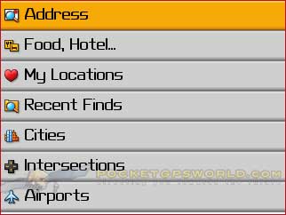
Arguably the most important part of a navigation application is the ability to locate your destination easily. No matter how good the routing and navigation is unless you can locate your destination then the rest is rather a waste of time...


Fortunately Garmin Mobile for Blackberry has one of the best destination finders I have used to date. At first the Garmin Mobile system is a little daunting, but with use it becomes second nature and pretty easy and intuitive to find places.


In the UK navigating to a destination is easy. The postcode alone is sufficient to put you close enough to see your destination.


In the US though a zipcode can cover a huge area. This is totally unsuitable for finding an exact location. Worse than that you cant even use a road name!! The one outside where I was staying was a few hundred miles long and changed its name a few times. In the 20 miles between Davenport and Kissimmee it went through at least 4 cities.


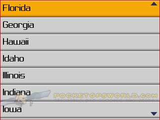
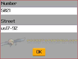
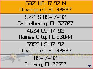
Often you may know the road and house number but not the city. Garmin have catered for this by providing a method of address location using State, House Number and Street Name. This then searches the database and shows all the cities matching that criteria. Of course you then have the problem of which city you should be going too, but most addresses should be pretty obvious.


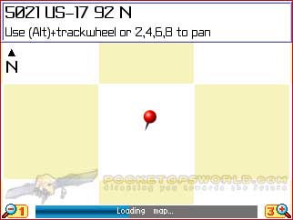
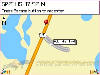
Once you have found your destination there are a number of things you can do other than set it as the point to navigate to. You can then select one of the options and view it on a map. You can also look for Points Of Interest (POIs) nearby.


I find this lookup feature really usefull. Often I want to see what is around a particular location. This is ideal for that sort of search. I must admit that I tend to use POIs much more when I am in the US than anywhere else. I suppose it is a different mode and style of driving.


Dont expect all POIs to be in the database though. I was in Millenia Mall in Florida standing right outside an Apple store and did a search for Apple. The closest result was "Big Apple Transportation" 2.9 miles away, and not a single Apple store was in the listings.


Routing Calculations

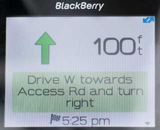
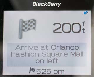
The next most important thing after you have located your destination is to get there... This is where the routing engine calculations com into play. The routing calculations for Garmin Mobile are done over the air on the Garmin Server. When you go off the designated route Garmin Mobile will dynamicaly request a route re-calculation to get you back on track.


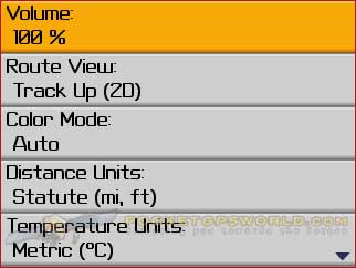
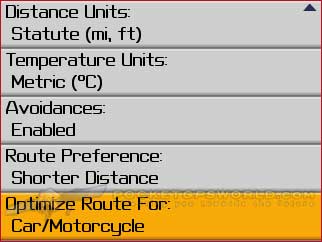
There are a number of settings that can be made to affect the sort of route that will be created:


Avoidances: There are a number of selections that can be made to be considered when calculating the route: Traffic; U-Turns; Highways; Unpaved Roads; Toll Roads and Ferries. Selecting one or more of these will alter the routing calculations


Route Preference: Here you can select either shorter distance or faster time. The time calculation is based on the posted speed of the roads in the route.


Vehicle Type: There are a number of different classes of vehicle that the route can be optimised for. These are mainly due to different access capabilities. For instance a pedestrian can walk on a footpath, but not down a highway, and vice versa for a car. Some roads are only open to public transport etc.


Routing calculations are processed on the Garmin server then the results sent to the BlackBerry. This allows the system to leverage the computational power of the large server releasing the BlackBerry for the display of the returned information.


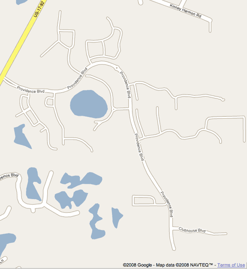
Now the interesting thing about routing is that you can always find a better route than a machine for an area that you know well. You have local knowledge and know when a particular intersection is busy, or that the sequence of a particular set of lights means you may wait 5 minutes or more before turning, but the Routing Server doesnt have that level of detail (yet!). The main question to ask from a route is: Does it get from A to B in a reasonable amount of time? 99% of the time the answer is going to be Yes!


Most of the routes we drove in Florida were pretty obvious ones. There are a system of main highways which when flowing properly will always be faster than taking back roads. Backroads become faster when the highways are blocked or slow. In theory the Garmin Mobile system should take into consideration traffic problems. I suspect that the one I nearly got caught up in had not managed to be transmitted to the server before I hit the tail of the log jam.


Garmin Mobile for Blackberry review


Garmin Mobile for Blackberry review


Garmin Mobile for Blackberry review


Garmin Mobile for Blackberry review

Garmin Mobile for Blackberry review

Garmin Mobile for Blackberry review

Other Features

One of the great features of off-board navigation is that it relies on a server to provide information. This of course is not restricted to the maping and routing.


As your position is known it can integrate all sorts of Location Based Service (LBS) features into the application. Currently the Garmin Mobile software supports Weather and Traffic. The fact that the data and calculations are done on a central server opens up a wealth of opportunity for value added services.


The weather section provides current and forecast information based on either your current position or that of the location you have found. I am not sure why but everyone has this facination with weather. It seems to be one of the most important things in people's lives, and certainly a converstion opener.


Garmin Mobile for Blackberry review

To my mind somewhat more important than weather is live traffic. Surely knowing if there are any delays along the route and either planning for them or plotting a route round them is more important than if it is sunny or raining at your destination. OK I admit it may be useful to know if it is icy or if a hurricane is coming through, but these should be picked up in the traffic information anyway.


Whilst I was on the road testing I only encountered one problem with congestion so to try and find some problems I selected New York and had a little look at the traffic there. Sure enough there were lots of delays and jams. The screenshots to the right show how you can drill down to map level with traffic data.


As I mentioned above the system knows about the road conditions and how long the delays are likely to be. This data is taken into consideration when planning routes (and I assume monitored as you are travelling). This means that if the road ahead is blocked then the Garmin Mobile software can automatically avoid the problem and get you to your destination on time.


The example I selected is one of those no win scenarios. The street is badly congested just after the bridge, but there is no alternative route without taking a long detour. Of course the rest of Manhattan will also be trying to take that detour too... Sounds like a day to turn round and work from home.


As I mentioned above the infrastructure of this system allows for a lot of value added features. With the cost of Gas skyrocketing I wouldnt be surprised to find a Gas Price Checker turning up soon.


Offboard Navigation Benefits/Pitfalls

So now you should have a good idea of the Navigation capabilities of the Garmin Mobile software it is time to look at the benefits and pitfalls in a bit more detail.


The main benefits of offboard navigation are:


1) Central mapping data

2) Centarlised routing

3) "Thin" client application

4) Location Based Services (LBS)

5) Connected Services


The pitfalls are few but serious:

1) Need to be connected to network

2) Cost of data


The whole premise of this application architecture is that it allows latest mapping, and fast changes to applications like adding new features and services. This works great if you have an unlimited data plan and good network coverage. With a "thin" client on the BlackBerry upgrades in the application and service will take a few seconds to apply and there is no need to either install or download lots of data. You only grab the most current data when you need it.


With most networks offering unlimited data at a reasonable price then the cost of data becomes less of an issue, particularly if it is being used for other services such as mail, internet browsing etc. What is the point of having a BlackBerry if you dont use it for data applications?


This leaves the main problem being network coverage. I was unfortunate in the location I was staying at with the poor signal quality, but it was somewhat off the beaten track. It was just really irritating to see a cell phone mast less then 800 yards from my window. What this meant in reality was that untill I had network coverage I couldnt use the system. Unfortunately I was unable to test what happens when you are navigating and go out of coverage as there was just enough signal to keep the connection until I entered the house. My guess is that it will be OK while you are in the area covered by the current map segment until you go off route and need to access the server again. At which point you will be stuck.


Mapping

The map data is supplied by Navteq one of the two main global suppiers of digital map data. This is stored on a central server and supplied to the BlackBerry over the air as needed.


The benefits of this system are that the latest mapping data can be provided to the application without having to distribute memory cards or have huge data downloads. This means that it is easy to manage the devices and cuts costs for both support and distribution.


The best way to discern the currency of the map is to go to a location where there is a lot of construction, preferably over a long period so you can tell when the roads were surveyed. I mentioned the roads where I was staying were not on the maps, but that was not a big surprise as the subdivision was less than 2 years old and often it can take that long to get to a satnav device.


I was most surprised and somewhat disappointed then to be looking at Google Maps (who use the same data provider as Garmin) to find that pretty much the whole subdivision was correctly mapped albeit that some of the roads were not named. The whole concept of off-board navigation systems is that they use the latest data, obviously this is not happening with Garmin Mobile.


Apart from that the maps were of the normal high standard that I have come to expect from Garmin and Navteq.


It should be noted that on my return from the US I fired up the Garmin Mobile application only to find that the mapping coverage did not include Europe.


Conclusions

Garmin are the first of the "big" satnav companies to venture into the off-board navigation market. The BlackBerry is a perfect device to do this on and the whole experience once installed was very good. From my experience I think that the initial installation and signup process is too cumbersome and problematic, but the support department gave excellent service.


For me what let the system down was the currency of the map data. I am normally supportive of companies providing map data that is slightly out of date as there are production and distribution latency delays that are unavoidable. However the offboard architecture makes it inexcusable for the latest mapping not to be available. This is after all what you are buying the product for.


Apart from that I was impressed with the ease of finding places which has always been a problem for me when visiting the USA. The routing and re-routing worked very well. There is a capability for you to save a number of favourite locations, but I couldnt find a way to add custom POI files.


Because the maps and routes are provided from a central server the navigation is totally dependent on adequate network data coverage. This makes Garmin Mobile for Blackberry more appropriate for urban areas than out in the backwoods.


Garmin have created an excellent platform for connected navigation. Time will tell if they can integrate further value added services into that platform as it becomes more mature. As more devices such as the iPhone become available with connected GPS the centralised server based architecture will explode with new Location Aware applications. Garmin have positioned themselves well to meet this upcoming shift towards connected navigation.

References

Review sample provided by www.buygpsnow.com
Manufacturers Website

www.garmin.com

Pocket GPS Contributor

Mike Barrett

Pocket GPS Contributor Website

www.Pocketgpsworld.com


Comments ?

Have any comments about this article ? Post them here.

CamerAlert Apps


iOS QR Code


Android QR Code


© Terms & Privacy

GPS Shopping