|
|
 |
 |
 |
 |
Garmin announce the nuvi 500 Rugged Navigation system
|
Date 13th August 2008
|
Last month at the British Motor Show in London Garmin announced a new "Rugged Navigation" PND: the Nuvi 500. This is a waterproof SatNav system for use by outdoor enthusiasts, drivers and mariners.
Some years ago one of the big names in Marine GPS talked about producing a PND that you could use in the car to get you to a marina, grab the SatNav from the car and put it in your yacht and sail off into the sunset. Well that never saw the light of day, but Garmin have gone one better and produced a waterproof GPS system that has quadruple usage models: Walking/Outdoor; Cycling/Motorbiking; Driving, and Marine GPS Navigation.
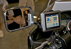
The main device is waterproof to IPX7 standard which means that the GPS case can withstand "accidental" immersion in one meter of water for up to 30 minutes. This makes it suited for use either on a bike, or on a boat.
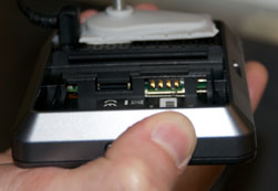
The maps supplied are the Navteq City Navigator NT which are country specific for the Nuvi 500 or full European or North American for the Nuvi 550. The PND is compatible with the Garmin Topo and BlueChart V2 map data. This can be added (at extra cost) via a microSD card which fits inside the battery compartment retaining the waterproofing.
As the PND is targeted at outdoor use one of the issues often encountered is that of battery life. The Nuvi 550 comes with a replaceable lithium-ion cell which is claimed to last for 8 hours. Longer than I can last on a mountain.
It is not clear from the documentation I have seen if the Nuvi 500 supports the import and export of routes, tracks and waypoints in the manner of existing Garmin handhelds like the 60CX or Colorado. It certainly does support user defined POIs.
From a driving point of view the Nuvi 550 supports the normal Garmin SatNav basic functionality of voice guided navigation, with turn by turn instructions. It also has itinerary optimisation and rerouting when going off course. It has RDS-TMC Traffic compatibility, and also supports photo navigation.
This is a basic unit and as such does not support some of the more advanced features such as Bluetooth hands-free operation, speech recognition, and Text to Speech voice prompts.
With a price tag of £299 the Garmin Nuvi 550 should be in the stores in September 2008.
I am hoping to be getting my hands on a review sample very shortly so I will be able to see if this is the ubiquitous device that Garmin are promoting. |
News Article by Mike Barrett
|
|
|
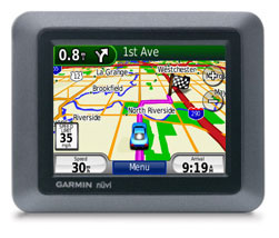
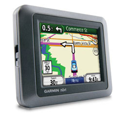
| Garmin nüvi 500 Specifications |
These specifications are from the Garmin Site.
Physical & Performance:
Unit dimensions, WxHxD: 4.21"W x 3.35"H x .9"D (10.7 x 8.5 x 2.3 cm)
Display size, WxH: 2.8"W x 2.1"H (7.2 x 5.4 cm); 3.5" diag (8.9 cm)
Display resolution, WxH: 320 x 240 pixels
Display type: QVGA colour antiglare TFT with white backlight
Weight: 215 g (7.6 ounces)
Battery: user-replaceable, rechargeable lithium-ion
Battery life: up to 8 hours
Waterproof: yes (IPX7)
High-sensitivity receiver: yes
RoHS version available: yes
Maps & Memory:
Basemap: yes (Europe)
Preloaded maps: yes
Ability to add maps: yes
Built-in memory: internal solid state
Accepts data cards: microSD™ card (not included)
Waypoints/favorites/locations: 1000
Routes: 10
Features:
Voice prompts (e.g. "Turn right in 500 ft."): yes (internal speaker)
Speaks street names (e.g. "Turn right ON ELM STREET in 500 ft.") : no
Speech recognition (navigate with voice commands): no
3-D map view: yes
Auto sort multiple destinations (provides most direct route): yes
Auto re-route (fast off-route and detour recalculation): yes
Choice of route setup (faster time, shorter distance, off road): yes
Route avoidance (avoid highways, tolls etc.): yes
Custom POIs (ability to add additional points of interest): yes
Hands-free calling with Bluetooth® wireless technology: no
FM traffic compatible: yes
XM® Navtraffic (includes basic weather) & Radio for U.S. compatible: no
MSN® Direct for U.S. compatible: yes
Multimode (switches modes to drive, hike, bike or boat): yes
Where Am I? (find closest hospitals, police & gas stations, nearest address & intersection): yes
Garmin Locate™ (marks position when removed from windshield mount): no
Photo navigation (navigate to geotagged photos): yes
MP3 player: no
Audio book player: no
Picture viewer: yes
Garmin Garage™ (select car-shaped icons for map navigation): yes
World travel clock, currency & unit converter, calculator: yes
Touchscreen: yes
Qwerty or ABC keyboard (choose keyboard layout): no
Remote control: no
FM transmitter: no
Headphone jack/audio line-out: no
Dead reckoning: no
Garmin Lock™ (anti-theft feature): yes
Motorcycle-friendly: yes
Geocaching-friendly: yes
Additional:
This USB mass storage device is compatible with Windows® 2000 or later and Mac® OS X 10.4 or later.
|
|
|
| Official Garmin Press Release |
Garmin introduces multi use nüvi 500 series for ‘Rugged Navigation’
Garmin the global leader in satellite navigation, today announced its first multi-use nüvi portable navigation device (PND) dedicated to walking, cycling, scootering, driving and boating in one rugged easy-to-use unit. The nüvi 500 series comes equipped with the latest technology from Garmin including NavTeq sophisticated mapping data and the ability to accept different types of mapping including TOPO for outdoor navigation and Blue Chart cartography for marine usage.
Clive Taylor, Garmin’s Director of Product, said, “The nüvi 500 series is a true chameleon in the gadget world, it extends the use of GPS across the range, from walking to cycling to driving to boating. It’s ideal for individuals or families who want to go and explore the great outdoors in every way they can. With the built-in compass and integrated Wherigo™ and Geocaching player the sat-nav’s use is extended beyond just navigating: Users can enjoy the fun of the many family treasure hunts and adventures available online.”
The new waterproof nüvi 500 series combines the latest Garmin navigation technology including Hotfix™, detailed NavTeq mapping, millions of points of interest (POIs) and traffic avoidance compatibility, for the times when sitting in a traffic jam is not an option. In addition, the nüvi 500 series comes standard with Garmin’s popular “Where am I?” safety feature. At any time, with a single tap of the car icon, drivers can display their exact latitude and longitude coordinates, the nearest address and intersection, and the closest hospitals, police stations, fuel stations and recovery service telephone number. In addition, with Garmin Connect Photos, users can choose from millions of geo-located images provided by Google’s Panoramio to photo-navigate on land or water.
With one touch, the nüvi 500 transitions between walking, biking, driving or boating mode;
Walking and outdoor pursuits
Ready for the great outdoors, the nüvi 500 models display shaded digital elevation mapping on the 3.5” water-proof touchscreen. This series comes standard with a compass page, track log and a removable, rechargeable battery for extended outdoor use. The integrated Wherigo™ and Geocaching player means the nüvi 500 series is ideal for getting the family to enjoy the great outdoors with the many downloadable ‘adventures and treasure hunts’ available online. Optional TOPO mapping will give additional detailed maps.
• Wherigo is a toolset for creating and playing GPS-enabled adventures in the real world. Use GPS technology to guide you to physical locations and interact with virtual objects and characters. www.wherigo.com
• Geocaching is an entertaining adventure game where individuals and organizations set up caches all over the world and share the locations of these caches on the internet. GPS users can then use the location coordinates to find the caches. Once found, the visitor may be provided with a wide variety of rewards, all a visitor has to do is ensure that if rewarded, they leave a gift for the next person who finds the cache. www.geocaching.com
Cycling/scootering
Where the nüvi 500 series stands out is in its ability to fit comfortably on a scooter or bicycle. Its user interface is easy to control and, with directions via Bluetooth and a scooter mount as standard in select European markets or optional extra everywhere else, it’s a great fit for getting around the busy town centres of Europe. The nüvi 500 series has a rugged design with UVA/B & fuel resistant material and bright clear screen that can be seen even in strong sunlight. If the weather turns and the rain comes down, its waterproof body ensures that the turn-by-turn directions get you to your destination using the most direct route and in the quickest time.
Driving
The nüvi 500 series’ intuitive interface greets you with two simple questions: "Where To?" and "View Maps." Touch the colour screen to easily look up addresses and services and get voice-prompted turn-by-turn directions to your destination. It comes preloaded with City Navigator® NT map data European region or individual country. It’s packed with millions of POIs and features digital elevation maps that show you shaded terrain contours at higher zoom levels. With the nüvi 500 series, you can also upload custom POIs such as ‘The Good Pub Guide’ and ‘Falk-Marco Polos Travel Guide’ offering thousands of great places to drink, eat and visit.
Boating
When loaded with optional BlueChart® g2 Vision marine cartography, the nüvi 500 series is great on the water, providing detailed chart-specific information, spot soundings, inter tidal zones, wrecks, port plans, restricted areas and more. The nüvi 500 is ideal for the occasional boating enthusiast who wants one navigational device for foot, car, bike or boat.
The nüvi 500 and 550 for Europe come preloaded with either country-specific City Navigator NT Map Data (500) or full European City Navigator NT Map Data (550) with detailed street and topographic mapping.
The nüvi 550 will be available in the UK in September at a RRP of £299 |
|
|
|
| Comments
|
 Posted by philpugh on Wed Aug 13, 2008 4:15 pm Posted by philpugh on Wed Aug 13, 2008 4:15 pm |
 |
You could argue that the Colorado series does this already. It doesn't have the touch screen but you can use City Navigator 2008 / TOPO GB / BlueChart on it and achieve the same navigational functionality.
However it's an interesting device and worth watching where it leads to in the near future. Even though the screen size is bigger than the C300 I suspect it is still too small to be used as your main marine chart plotter device - you just wouldn't see sufficient of your surroundings to be absolutely sure of your safety. Shame they felt necessary to remove the BT phone capability. Hands free on my bike would be quite nice  That seems to be the problem - more capabilities less functionality. That seems to be the problem - more capabilities less functionality.
Phil |
|
| Posted by MikeB on Wed Aug 13, 2008 5:12 pm |
|
I think that there is a market for an all singing, all dancing GPS device, but I dont think it is possible to create one without bending (or breaking) the laws of physics and nature.
For outdoor navigation I would like a small palm sized device that is light and lasts forever on a set of batteries. It must be fully waterproof and float.
For driving I need a slightly bigger device with good clear audio. BT handsfree as well.
As you have noted for Marine navigation you need a larger screen.
These requirements seem to be somewhat contradictory 
I currently think the best convergence device (from Garmin) is currently the Oregon, but from what I have seen of the specs it lacks audio so would not be great for driving. However on the basis that utopia is impossible with these criteria I think I would go for an Oregon 400t as the best compromise solution.
Mike Barrett |
|
| Posted by blackrat62 on Thu Aug 14, 2008 3:27 pm |
|
Shame about the lack of an audio out plug (present on the Zumo) - this is useful for motorcyclists to plug in earphones so they can hear directions. Still it might bring down Zumo costs - I'll be keeping an eye.
|
|
| Posted by ianchapp on Tue Aug 19, 2008 9:50 am |
|
I currently use a Quest 2, following a Quest 1 and Etrex Legend. Probably 80% of my use is on motorcycle. My MP3 player's just bitten the dust, and also I'm starting to get frustrated at my Quest 2's re-calculation speed particularly in cities.
So, if I'd like a built-in MP3, is the Zumo my only real option? I'm a little concerned by it's HDD (that's what's just blown on my MP3 - again!). Speaking to a guy at Garmin, he seemed to suggest I waited for the Nuvi, but I think he erroneously thought it did MP3's. And do we know how the processing spped compares between the two - is the Zumo in fact getting long-in-the-tooth now? And I assume tracklogs are retrievable from the Nuvi by USB2? In fact, I'm not quite clear what advantages the Nuvi 550 will have over the Zumo 550??? I'm not too bothered by BT.
The Zumo does appear to be very good value, with all that's "in the box", I'm just slightly concerned that it's part way through it's life-cycle, has a HDD, and also rather unusually I don't think the fields are customisable?
Thanks.
www.aslc43.dsl.pipex.com
|
|
| Posted by alan_sh on Wed Aug 20, 2008 6:52 pm |
|
The Zumo does not have a hard disk in it - it's all solid state memory.
|
|
| Posted by ianchapp on Thu Aug 21, 2008 11:43 am |
|
Thanks Alan, not sure where I got that from - it did sound strange!
Any ideas why I might prefer the Nuvi to the Zumo?
|
|
| Posted by gsandy on Sun Aug 24, 2008 9:30 am |
|
When I first saw the review of the new Nuvi I thought "damn it, I've just bought a Zumo (to replace my stolen 2720) and Garmin have brought out a new bike system". The only plus that the Nuvi seems to have over the Zumo is price but on the Nuvi you lose the MP3 player, headphone/mic sockets, Bluetooth pairing to both phone and headset, hard wiring to bike comms systems and the more useful than expected ability of the Zumo 550 to speak street names.
Looking at the specification of the Nuvi it seems to be similar to satnavs costing half the price but with the addition of a waterproof case.
I don't think the fact that the Zumo has been around for a while makes much difference. The Zumo hardware is fast enough and I can't see anything on the Nuvi spec. that would suggest it is any better. On the software side Garmin are pretty good at supplying updates so the Nuvi software is unlikely to be any better.
If the main use is on a motorcycle the Zump is a great satnav that is still great when used in a car. The Nuvi seems to be a car satnav that could, at a push, be used on a bike but has little advantage over using a cheap car system with a plastic bag over it..
|
|
| Posted by ianchapp on Mon Aug 25, 2008 6:31 pm |
|
Thanks gsandy, that's pretty much what I thought!
Is the MP3 player good? Somewhere I read that it was a "gimmick"! Not sure why tho.
PS Just realised you're probably "gs andy" rather than "g sandy"? I ride a 1200GSA.
|
|
| Posted by Skippy on Fri Oct 03, 2008 9:13 pm |
|
Ahhh, I remember the good old days when all the Garmins were rugged, waterproof and could navigate on road, water, air and off road.
Then they brought out the dumbed down Nuvi - now it's come full circle, except there's no text-to-speech or bluetooth.
A sat nav designed by engineers then the marketing department dumbed it down. 
Gone fishing! |
|
|
|
 |
|
|
 |
 |
 |
 |
|
|


