Three
geostationary satellites and a complex network of ground stations will carry out
the task. The three satellites will send out a ranging signal similar to those
transmitted by the GPS and GLONASS satellites. However, the signals will be more
than another opportunity for users to fix a position. They will also provide
information about the accuracy of position measurements delivered by GPS and
GLONASS so that a train driver, for example, will be able to assess whether the
position is accurate enough to rely on.
This
information, or integrity data, will be modulated onto the ranging signal. It
will include accurate information on the position of each GPS and GLONASS
satellite, the accuracy of the atomic clocks on board the satellites and
information on disturbances within the ionosphere that might affect the accuracy
of positioning measurements. The EGNOS receiver, which is more sophisticated
than a standard satellite navigation receiver, will de-code the signal to give a
more accurate position than is possible with GPS or GLONASS alone and an
accurate estimate of errors.
The
EGNOS signal will be broadcast by two Inmarsat-3 satellites, one over the
eastern part of the Atlantic, the other over the Indian Ocean, and the ESA
Artemis satellite which will be launched into position above Africa later this
year. Unlike the GPS and GLONASS satellites, these three will not have signal
generators on board. A transponder will transmit signals up-linked to the
satellites from the ground, where all the signal processing will take place. The
sophisticated ground segment will consist of about 30 ranging and integrity
monitoring stations (RIMS), four master control centres and six up-link
stations.
The
RIMS measure the positions of each EGNOS satellite and compare accurate
measurements of the positions of each GPS and GLONASS satellite with
measurements obtained from the satellites’ signals. The RIMS then send this data
to the master control centres, via a purpose built communications network.
The
master control centres determine the accuracy of GPS and GLONASS signals
received at each station and determine position inaccuracies due to disturbances
in the ionosphere. All the deviation data is then incorporated into a signal and
sent via the secure communications link to the up-link stations, which are
widely spread across Europe. The up-link stations send the signal to the three
EGNOS satellites, which then transmit it for reception by GPS and GLONASS users
with an EGNOS receiver.
Considerable redundancy is built into EGNOS so that the service can be
guaranteed at practically all times. At any one time, only one master control
centre will be “the master”, with another on stand-by to take over
instantaneously should the first one fail. There is redundancy in the up-link
stations, too. Only three are needed to operate EGNOS, one for each satellite.
The other three are in reserve in case of failure.
What
kind of satellite does EGNOS require?
EGNOS
relies on the availability of geostationary satellites equipped with navigation
payloads to broadcast a GPS look-alike signal containing integrity and wide-area
differential corrections to users. The operational system uses three satellites
to disseminate this data: Inmarsat III Atlantic Ocean Region–East (AOR-E) at
15.5şW; Inmarsat III Indian Ocean Region (IOR) at 64şE; and ESA ARTEMIS at
21.5şE
Ground Segements
The
EGNOS ground segment is composed of: the Master Control Centres; the Ranging and
Integrity Monitoring Stations; the Navigation Land Earth Stations; the EGNOS
Wide Area Network; and support facilities.

Once the EGNOS system is complete there will be four Master Control Centres (MCC),
each having:
a
central control facility for:
- monitoring and controlling EGNOS G/S
- mission monitoring and archiving ATC I/F
a central processing facility
with a real-time software system developed to high software standards in order
to:
- provide EGNOS WAD corrections
- ensure the integrity of the EGNOS system for
users
- utilise independent RIMS channels to check
corrections
|
|
 |
|
RIMS Location
|
|
Ranging and Integrity Monitoring Stations
The EGNOS system will have 34 Ranging and Integrity Monitoring Stations (RIMS)
Technical data
- a GPS/GLONASS/GEO receiver
- an atomic clock
- the EGNOS RIMS network is based on TCP/IP,
Framerelay and VSAT
Main functions
- perform pseudorange code/phase measurements
towards SVis (GPS L1 and L2 + GEO/GLO L1)
- demodulate SIS messages
- mitigate local multipath and interference
- support the detection of anomalies in
signals from space (e.g. EWF GPS/GEO)
- packet and transmit data to the MCCs via
FEE/EWAN
- provide BITE and M&C capabilities
- provide time offset UTC(k)/ENT (UTC RIMS)
Navigation Land Earth Stations
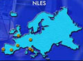
The first stage EGNOS Advanced Operational Capability architecture foresees
seven Navigation Land Earth Stations (NLES), five of which will uplink EGNOS
messages to the Inmarsat III Atlantic Ocean Region – East (AOR-E) and Indian
Ocean Region (IOR) satellites, and two of which will uplink EGNOS messages to
the Artemis satellite.
The
main functions of the NLES will be to:
-
generate a GPS-like signal and transmit this to a GEO transponder
-
synchronise this signal to EGNOS time (ENT) at the output of the GEO L1-band
antenna
-
control the code/carrier coherency
-
transmit the GIC and WAD messages to satellites in geostationary orbit.
EGNOS Wide Area Network
The EGNOS Wide Area Network (EWAN) links all the EGNOS components together.
Support facilities
Support facilities are made up of the Performance Access Check out Facility (PACF)
and the Application Specific Qualification Facility or ASQF.
The
PACF is a single unique centralised facility that provides non-critical
operations support, engineering support and some maintenance and logistics
support capabilities for the EGNOS operations system. ASQF is a set of tools
that provide the technical means through which user-specific applications are
qualified in the domain of operations.
For
more reading on the current GPS setup, check out one of our other articles
How Does GPS Work.