|
 Review by
Lutz Bendlin Review by
Lutz Bendlin
Introduction
Deluo is a relatively
new player in the market of Pocket PC navigation systems. The
product
was available for the American market for a while (developed
by Netropa and coming in a variety of OEM versions), but now
it looks like Routis becomes a serious competitor, especially with the feverishly
awaited addition of Canada maps (all big cities and some areas in
between are covered) and the neat double feature of the application being
available on both a normal PC and on the Pocket PC.
 Deluo
Routis comes in different versions - either as
software only or bundled with a cabled GPS receiver
based on the Evermore chipset (which gives average
performance and power consumption) or a CF card
receiver, but it does also accept any other NMEA
based GPS receiver (which is another positive change
from the previous version where the program seems to
have been tied to the Deluo hardware). Deluo
Routis comes in different versions - either as
software only or bundled with a cabled GPS receiver
based on the Evermore chipset (which gives average
performance and power consumption) or a CF card
receiver, but it does also accept any other NMEA
based GPS receiver (which is another positive change
from the previous version where the program seems to
have been tied to the Deluo hardware).
Application Installation is easy
The
installation
of Routis is pretty straight forward and follows the
Mobile Navigator model. Well, at least partially. Routis comes with
two CD's, one for the eastern part of the US and Canada, and the
other one for the western part. Any of those will get the
application onto your Pocket PC via the standard ActiveSync process.
(I have not seen any description of an application update process -
maybe Deluo will offer that later from their website). Once the
program is on your Pocket PC (or on the laptop, for that matter), you
need to decide how you would like to define the map area to use for
the navigation.
Map selection
- city radius or trip range
This is accomplished with a separate application called Map Loader
and can be done either by specifying a place that is in
the center of your area of interest, and the selecting the
radius of map data to export, or - and this is where
Routis shines - if you plan a trip between two or more US
states or Canada provinces then you can specify the states/provinces where you want
to have detailed maps, and Routis automatically adds the connecting major roads between
those route end points.
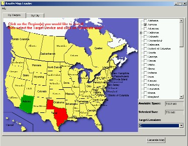
So for
a route from Houston, TX to Phoenix, AZ it is sufficient to load
the maps for Eastern Texas and for Arizona, and Routis will automatically include
the connecting "barbells" (the highways) in West Texas and New Mexico.
One word of caution: Maps tend to get
quite big quite fast with this approach, and you should make sure
that you have plentiful RAM available for Routis to run. Deluo
acknowledge this to be an issue in the current version and have
promised to try and limit the memory hungriness in one of the
next releases. In the meantime you can help yourself by putting
everything possible onto a memory card such as SD or CF - including
the application itself with all its sound files.
Note:You will have to be inventive if your
Pocket PC has a non-English OS - which is likely when you live in
Montreal - because Routis may not find the sound files where it expects
them, and again Deluo have promised to fix this path hard coding
issue.
Map
data can be installed onto the Pocket PC (into main memory or on a storage card), or directly onto one
of the PC's hard disks (which
could be a card reader with your storage card again). The
last option is strongly recommended unless you enjoy torturing ActiveSync
and yourself with the transfer of 100 odd Megabytes of
data.
And
yes, for the ones who need to know all the details - Deluo are
using Navtech maps, so you can expect about the same level of map accuracy
as with Mapopolis - except for the street names and house
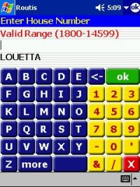
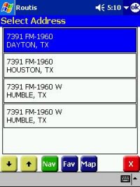
numbers. Here Deluo Routis sometimes just doesn't know the house
number that Mapopolis can easily find and show. Now what about
the street names? Well, Americans love their streets, and they
give them multiple names. Highway 10 is also going as IH10 or I10 or Katy
Freeway or Katy Fwy and so on. Routis does only know one of the street
names, and you will have to know how Routis
is spelling it. This eventually also affects the contact navigation where you have to
specify the contact's address in a way that Routis likes - otherwise it
wouldn't navigate there.
GPS installation -
huh, already done?
This is very
straight forward again.
Routis has an automatic mode that assumes the GPS receiver to be the standard NMEA 4800
on COM1, which is fine for the average user with a serial
GPS. But it also allows for manual setting of COM port and baud rate. Most
of the time you will not waste any thought about the GPS setup
part - it simply works. It is even difficult at times to understand exactly
in what state the GPS reception is - you will have to
carefully check the color used in the satellite display or the color of
that little arrow showing your position (green is ok while red means no fix) and the height
indication (to see if you have a 3D fix or not)
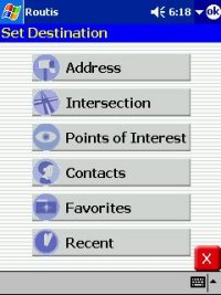
Selecting a route
- quite a few taps, but lots of choices
Fortunately
Routis doesn't require you to select a starting point for your route
- it assumes your
current GPS position is good enough, which is excellent for the average
user. (The route-well-in-advance-planners amongst you can still tap and hold on any
location to bring up the context menu where they can specify the location to be the start or destination
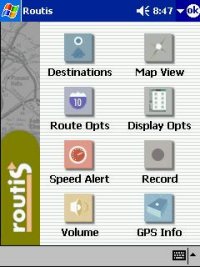
of the route). You start by tapping the Menu button on the main screen and
then tapping on "Destinations".
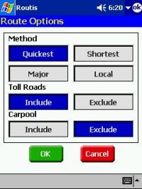 Tuning the Route
calculation Tuning the Route
calculation
You can
influence the
way a route is calculated. "Quickest" and "Shortest" are pretty
much standard, but there are some very nice features that Routis is
offering for the American users with their, um, interesting city
architecture and the permanently congested roads. "Major" helps
to avoid the back roads, which is advisable if you don't know
the area and you feel it is safer to stick to areas where many
people are gathering, "Local" is for the performance geeks that always
expect the navigation program to know the same fancy shortcuts
that they have found over the years. Let me tell
you, Routis has just that for you. When it is rush
hour, all the highways are stuffed, and I really need to get somewhere pretty damn
quick then a tap on "Local" solves most of my problems
reliably.
Toll Roads are
quite common
over here, and they are not cheap. So it is a good thing to be
able to avoid those money-eaters. Now "Carpool" is something funny - these
are roads on top of the major highways that have less exits and
(supposedly) less traffic jams. You can ride them at certain times
(in the morning towards the city, in the afternoon back home), but
only if there are two or more people in the car. (And no,
the inflatable doll doesn't count). So theoretically Carpool lanes should
decrease the travel time considerably. I cannot tell
you if that works because whenever I tried the carpool lane
was closed for maintenance or open in the wrong direction.
Now let's actually do some driving, shall
we?
Once you started your trip Routis is taking care of your
every move. The female voice (some call her "Chatty Cathy") gives you a lot of information
(information, as opposed to data, is something that you would not
have guessed before). One of her special features is that she announces the
next turn not just when you approach it, but also immediately after
you have finished the previous turn. At first I found that
strange, but I got used to that feature pretty quickly, and now I am
missing this pre-announcement feature in the other packages that I
am using. It gives you some time to mentally prepare for what you have
to do next, and you do not have to perform any stunts to move from
the leftmost lane to the rightmost lane because the application just
told you to "turn right in 300 feet". At least you don't have any
more excuse for performing the stunts.
The voice also handles consecutive turns very well, including
phrases like "turn left then immediately turn right" so you will not
miss any important turns that are close to each other. I still have
to see a Pocket PC navigation program that handles the ubiquitous
Texas U-turns as U-turns and not as "turn slight lift then turn
left" but it is really difficult to implement - sometimes the turns
are just far enough apart to be recognized as separate
turns.
If you don't like the way Cathy talks to you you can shut her
off (see the speaker icon on the main screen) or adjust the volume
with the speaker icon on the menu bar. Fortunately Routis used
pre-recorded WAV files for the announcements, so if you are into
audio processing then you can craft your own voice snippets pretty
much like you can do for TomTom. Since I am easily annoyed with
redundancy I have replaced the in.wav and feet.wav files with an
empty wav file (zero length files won't do here) so instead of "In
300 feet turn right" she now says "300 turn right". A bit of a
rallye feeling, isn't it?
One thing worth mentioning is that Routis even
tries to tell you the street numbers. While this works only with the
major highways it adds a nice touch and makes you forget
that you might have wanted to have a true Text-to-speach (TTS) engine this time. Personally
I am not overwhelmed by the currently available TTS
systems.
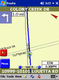
While driving Routis shows you what street you are on,
and what house number range you are currently passing. That's
very nice when you are just curious, or when Routis wasn't accepting
that odd house number of your destination address. The street
display is transparent so you can still see the map through it.
This neatly improves the screen real estate usage.
The top left corner will have a pictogram of your next turn,
and the top right corner shows where North is. If you tap that arrow
the display changes and shows you what direction you are heading.
You can switch map view between Heading Up and North Up by tapping
the "N" symbol in the menu bar.
The Menu and Speaker buttons were already covered.
In the center just above the current street name you see these
tiny little +/- icons. These are supposed to be used to change the scale.
But they are so hard to hit that it nearly doesn't make sense to do
this while driving. Fortunately the rocker pad up/down on your
Pocket PC does about the same thing. Finally, the right bottom corner shows either distance to
destination, ETA, remaining time, or your speed. It doesn't change
like in the above animation - you will have to do that yourself by
tapping that area.
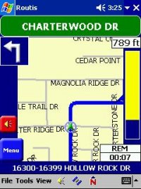
The Guidance Screen
When you approach your next turn a
special guidance screen pops in. It will show you the name of the
street into which to turn (even tries to mimic a street sign - how cute)
as well as the yellow bar on the right that turns more blue the
closer you get to the turning point. You can control the way the
guidance screen works, either automatic or manual (there's a menu item
under "View" for that), but it still left me looking for a "real"
guidance screen. We all know that operating the
navigation application while driving is not recommended (Routis even puts a
big legal disclaimer up that jumps into your face whenever
you start the application), and I would think the Guidance screen
could have made a pretty good driving safety feature if the map display were
replaced by the turn arrow and the street names would appear in bold white font. More on
that later.
Rerouting
If you chose not to follow the advice
that Routis gave, it will nearly instantly recalculate the route.
It does that with a little trick. For the first few
moments Routis tries to get you back onto the original track, which involves
a number of U-turn proposals. Only if you persistently fail to
follow that advice Routis will then recalculate the route based on
your current destination. Nothing to complain about here -
eventually it was your fault, so you cannot blame the application
for trying to get you back on track. Calculation speed is
decent, but it also depends on the amount of map data that needs to
be considered.
Sometimes Routis (as
many other navigation applications) is not really sure what road you
are on. Routis does automatically lock to the nearest road, but that
may not be the right one. There's no way to disable the locking, so
you are always advised to verify the directions against the real
world outside your car window.
Stopover? Can
do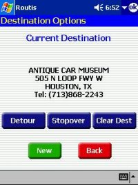
Many navigation programs for the
Pocket PC lack the ability to specify stopover locations - that
is bad if you want to do a round trip and would like to plan
it in one go, or if you have to go via a certain place. While Routis doesn't
allow you to enter a stopover when you plan the route
it does help you after you started your trip and then want to pass
by another place en route to the final destination. Whenever you
enter the "Destinations" selection and a destination had already been
set Routis presents you with the choice to clear the original
destination (which takes you back to the map screen), to select
a new destination or to enter a stopover location. The original
destination will be saved until you have reached the stopover
location, and then Routis asks you if you now want to proceed to the
original destination. At this point you could confirm and then enter
yet another stopover...
Detour - Certainly!
When you see a traffic jam or
another obstacle ahead in your driving path you can try and ask Routis for
a detour. It will give you up to three choices of distances to avoid
(based on the actual map data) and then it recalculates the
route accordingly. This works very well, especially because you don't need
to think about how much of a distance to avoid - Routis will tell you
what it can do for you. Routis does not allow you to
enter permanent avoids (one of the big features in TomTom Navigator). My home street
recently got dug up (side kick at NavTech: that was three years ago!)
, and now there's a water channel between me and the
highway and I always have to go a different way to
get there. And still every time Routis suggests I drive through the water. That's
a bit annoying, to put it mildly.
Ergonomics and
Usability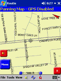
One thing I liked about Routis is how the
application is hiding the complexity of some of the features it
offers from the user's view. Routis may not be as powerful as TomTom
Navigator with their abundance of features and personalization
options, but it certainly equals in ease of use and intuitiveness.
There is a user's guide and a readme file, but I haven't touched
those yet, simply because there was no need for that. The average
user will find that most of the features are where they expect them to be, and
some even show up in a way that makes you think "That's
kind of neat, why didn't I come up with that idea?" Want
an example? You can chose to have Routis control
the switch between day and night display. It calculates the Almanac at
your location, so it knows when the sun is setting at the
place where you are. Shortly after that it switches between the lighter colored day
view and the darker night view. Seamlessly, without any user interaction. It also tells you
all kinds of stuff about the moon, but I didn't really understand what that
has to do with navigation - maybe you shouldn't drive at full
moon? Next thing they may also include a biorhythm calculator.
Don't blink.
Besides that, there is the already mentioned option to replace
the voice files with your own creations, the convenient switch
between English and metric system, and a very pleasant way the
application handles the voice commands in the English systems. It
doesn't try to talk in "three quarters of a mile" but instead says
"point seven miles". At least to me who is used to the metric system
that approach is much easier to cope with. (Unfortunately it doesn't
help with the real life street direction signs - those are still
showing that "3/4 mile" distance. You could probable initiate a
heated argument about which system is better, but eventually I
think the navigation program should help the user to match the
information to the one he/she is getting from the eyes. Which
also reminds me of the differences in street names between
applications and real street signs - but that's another
story)
So about the only thing that is missing is a real safety
screen. There is a safety speed warning, and a "fog driving mode"
which makes the program beep whenever you approach an intersection
(a bit of a scary feature come to think of it - just imagine
everybody using it), but that's not it. I wanted a screen that would
pop in at a certain speed, and would only have the essential data
to show, so I don't get distracted from watching the traffic around
me.
The Good
-
Safety warning splash screen at program start
-
Voice commands come in plenty, they are timely, easy to understand
and unambiguous
- voice files can
be exchanged
- Smart reduction of user accessible features
- Good usage of screen real estate
- mostly tappable UI - no need for a stylus unless you have
really big fingers
- connecting highway maps are loaded with start and
destination state or province
- allows for stopovers and detours
The Not Yet Perfect
- some taps could be saved by combining screens, especially
when selecting destinations
- essential information like ETA, time to destination,
distance to destination cannot be viewed at same time
-
zoom controls are too small - use rocker pad instead
-
no personalization (colour schemes, road type speeds, POIs, permanent
avoids etc)
- memory-loving. Make sure you have plenty
available
Summary
Deluo
Routis is an excellent program for the people among us that want to
have an application that is easy to use and does not overwhelm the
user with functionality. Many of the more complex things that
Routis actually does are nicely hidden from the user's view. I would
place Routis in between Mapopolis and TomTom Navigator. Routis
shares the excellent NavTech map base with Mapopolis and even
manages to add one or two extra map functions (like the display of
the house number range on your current location), but Routis easily
avoids many of the usability quirks of Mapopolis. It is nearly as
powerful as TomTom, even though it doesn't allow for custom color
schemes or custom road type speeds. The ease of use of Routis is
certainly on par with TomTom and - as said before - many users will
be happy that they do not need to acquire a masters degree in TomTom
configuration to get satisfying results from their navigation
system. Well done, Deluo!
A good
introduction to Deluo Routis can also be found on the
Deluo website.
|